Showing 2297 items matching "1885"
-
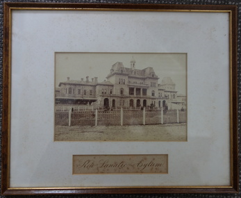
 Orbost & District Historical Society
framed photograph, C1900
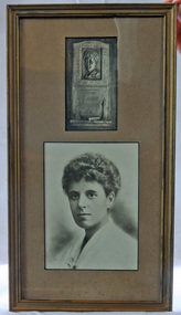
Link to 524. Grace Elizabeth Jennings Carmichael (1867-1904), poet and nurse, was born on 24 February 1867 at Ballarat, Victoria, daughter of Archibald Carmichael, a miner from Perthshire, Scotland, and his wife Margaret Jennings, née Clark, from Cornwall, England. . About 1880 the family moved to Gippsland where Henderson managed a station near Orbost. Grace learned to love the Gippsland forest. She began to express in verse her understanding of the sights, scents and sounds of the bush, often writing in some remote clearing, her manuscripts stored for privacy in a hollow trunk. The Bairnsdale Advertiser published her first story, and the Weekly Times an early poem; then on 28 November 1885 her poem 'The Old Maid' was published in the Australasian under her pen name Jennings Carmichael. Encouraged by its editor, David Watterston, Grace sent nearly all her subsequent verse to that newspaper. (Read more by Lindsay Gardiner in Australian Dictionary of Biography.)This is significant to the Orbost region in that it is associated with a woman who is certainly our foremost female poet.A framed photograph of a plaque above a photograph of head and shoulders of a woman. They are framed in a gold wooden frame and mounted on a light brown buff card.carmichael-jennings-grace poet memorial-plaque memento -
 Warrnambool and District Historical Society Inc.
Bottle, Fletcher Warrnambool
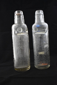
These marble stopper bottles came from the Warrnambool aerated waters factory of John Fletcher. A marble stopper bottle was filled upside down so that as soon as the filling stopped the marble was forced down to seal the bottle against the rubber ring. Pressure inside the bottle would keep the marble pressed against the top of the bottle. To open the bottle the marble was pressed down where it would fall into the neck of the chamber below. The marble would stay inside the chamber when the bottle was tilted up for drinking. As a young boy John Fletcher worked at the cordial factory of John Rowley in Banyan Street, Warrnambool. He then worked in Koroit Street, Warrnambool at the Union Cordial Factory of John Davis. This factory had been established in the 1860s. In 1885 John Fletcher bought the business of John Davis and continued it on until 1930 when it was bought by Ralph Reeves. John Fletcher manufactured lemonade, tonic waters, soda water, sarsaparilla, cordials, ginger ale, hop beer and hop bitters. These bottles are of interest, firstly because they are good examples of the marble stopper bottle type of bottle, no longer in use. They are also important because they are John Fletcher bottles and he was a prominent businessman in Warrnambool for over 40 years.These are two glass bottles. They have a rounded base and body with deep indentations which give a narrowed aperture to the top of the body and the neck. The neck is round and tapering to a moulded opening at the top of the bottle. Both bottles had a round rubber ring inside the bottle, with one lodged in the bottom of the bottle. Both bottles have a green glass marble in the neck of the bottle. The name of the manufacturer of the lemonade is impressed into the body of the bottles. ‘J. Fletcher’s Aerated Waters Koroit Street Warrnambool’ ‘Lemonade’ ‘This bottle is the property of John Fletcher Warrnambool & cannot be legally used by others’ ‘A.G.M.’ john fletcher warrnambool, cordial manufacturers in warrnambool, history of warrnambool -
 Eltham District Historical Society Inc
Photograph, The Art Engraving Company, Memorial Card: Alexander Stewart, 1897
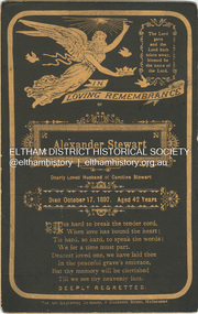
Memorial card given out to family and friends. Alexander Kirk Stewart died October 17, 1897 aged 42 years. Husband of Caroline Fairie (nee Kidd - born 1856 at sea), they marriedin 1885. Caroline died in 1901 at Diamond Creek aged 45 years. Memorial Cards were commonly handed out to those friends and family paying their respects at the loss of a loved one. CABINET 1866-1905 The Cabinet photo was introduced in 1866 in answer to a demand for a larger format photograph which could be mounted for a cabinet or on the wall. They were 4.5 inches by 6.5 inches (11.5 x 16.5 cm), more than twice the size of the cdv. They cost about twice as much as a cdv but eventually displaced them. They were not extensively produced until 1880 and had ceased by 1905. Coloured mounts, especially maroon or green, indicate a date between 1880 and 1890. - Frost, Lenore; Dating Family Photos 1850-1920; Valiant Press Pty. Ltd., Berwick, Victoria 19911897, alexander stewart, cabinet photo, caroline fairlie stewart (nee kidd), marg ball collection, memorial card, shillinglaw family photo album 3, the art engraving company -
 Eltham District Historical Society Inc
Photograph, Yeoman and Co, Mary Shillinglaw, c.1898
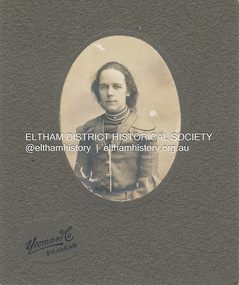
Mary Shillinglaw born November 5, 1880 at Bundoora, Victoria was the sixth child of Phillip Shillinglaw and Sarah Ann (nee Kidd). She commenced school at Eltham State School No. 209 (Register No. 423) in 1885 at age 4 years. Mary did not marry and spent most of her life at Wattle Brae (Shillinglaw Cottage). In his Will, Phillip Shillinglaw provided that any of his unwed sisters would be able to live at Wattle Brae, rent free. When Eltham Shire Council aquired the property in 1963 to build new Shire Offices, both Mary and her sister Lizzie (also unmarried) were still living at the cottage. Council paid for the women to relocate. Mary moved to Elizabeth House, a nursing home in Ivanhoe but found it very hard to adapt to her new surroundings and living consdtions. She died there only a few months after departing Eltham on October 29, 1963 at age 83 years. Lizzie died June 28, 1972 at age 93 years."Mary Shillinglaw"marg ball collection, 1883-1918, 1898, mary ann shillinglaw (1880-1963), yeoman & co photographer prahran -
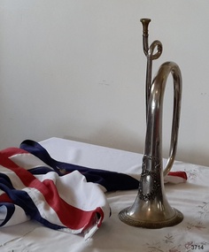 Flagstaff Hill Maritime Museum and Village
Instrument - Bugle, 1861
Bugles have been used for hundreds of years for communicating instructions, particularly in battles, and announcements such as calls to assemble and various other routines of the day, particularly for infantry and military units. This pure silver bugle was presented to the Warrnambool Rifle Volunteers by Lady Helpman, on behalf of the Ladies of the District of Warrnambool, on June 18th, 1861. Lady Helpman's husband, Captain Benjamin Franklin Helpman, was Warrnambool Harbour master. The gift of this silver bugle was presented to the commanding officer of the Warrnambool Volunteer Rifle Corps, Captain Bushe, who then passed it on to the Warrnambool Volunteer Band. On 11th August 2016, during a ceremony at Flagstaff Hill, the Australian Army handed over custodianship of two very significant historical items the 1885 W. Clarke Trophy and the 1861 Warrnambool Ladies Silver Bugle to Warrnambool City Council, for display at Flagstaff Hill Maritime museum, both heritage listed items are strongly connected to the city of Warrnambool and form an integral part in the history of the Warrnambool Garrison.The Silver Bugle is locally significant to the community of Warrnambool for its connection to the Warrnambool Volunteer Rifle Corps., which formed part of the original Warrnambool Garrison to protect the Warrnambool Harbour. The site of the 1888 Warrnambool Garrison and Fortifications is Victorian State Heritage-listed is significant for its intact and operational nature and is one of the best-preserved pieces of Victoria's early colonial heritage. Silver alloy Bugle, with brass mouthpiece, a long tube of metal, narrow at the mouth end and gradually flaring to a wider at the bell shape at the other end. The tube is shaped into 3 bends. The front of the bell has an elaborate design of a ribbon banner attached above an oval floral wreath enclosing an inscription. The outer rim of the bell has an impressed ancient Greek geometric border.On ribbon banner “Armed for the Right”. Within the wreath “TO THE / WARRNAMBOOL / VOLUNTEER RIFLE COMPANY / this tribute of due appreciation / is presented by / THE LADIES / of the District / Warrnambool 18th June / 1861”flagstaff hill, warrnambool, shipwrecked coast, flagstaff hill maritime museum, maritime museum, shipwreck coast, flagstaff hill maritime village, great ocean road, silver bugle 1861, bugle musical instrument, lieutenant benjamin helpman, doctor breton, captain bushe, bugler corrigan, drill instructor bernard, warrnambool volunteer rifle corps 1861, statistics of warrnambool volunteer rifle corps 1861, warrnambool volunteer rifle company, warrnambool rifle volunteers, warrnambool volunteer band, armed for the right, wall’s family hotel warrnambool, warrnambool garrison, volunteer corps -
 Eltham District Historical Society Inc
Negative - Photograph, Eltham, Vic, c.1890
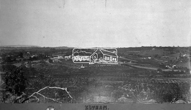
View looking northeast from present day Ely Street (near intersection of present day Cronus Court and Porter Street) across what will become the site of Eltham High School towards Main Road showing the Eltham Courthouse and Police station. View is very similar to the sketch of Eltham published in 'The Illustrated Australasian News', December 26, 1884, p212. Note the large bluestone cell block behind police house and stable. George Knapman's Shoeing Forge next to the courthouse and the concentration of buildings around the Evelyn Hotel and Watson's Eltham Hotel on opposite sides of Main Road at Pitt street. Also note George Stebbing's cottage (c.1860) on Pitt Street behind the courthouse and 'Sunnyside' (home of W.J. Taylor built c.1885) at the top of the hill on Bible Street. In the foreground are orchards running up to the main street, Maria Street and also between Brougham Street and Dalton Street bordered by Bible Street.This photo forms part of a collection of photographs gathered by the Shire of Eltham for their centenary project book,"Pioneers and Painters: 100 years of the Shire of Eltham" by Alan Marshall (1971). The collection of over 500 images is held in partnership between Eltham District Historical Society and Yarra Plenty Regional Library (Eltham Library) and is now formally known as the 'The Shire of Eltham Pioneers Photograph Collection.' It is significant in being the first community sourced collection representing the places and people of the Shire's first one hundred years.Digital image 4 x 5 inch B&W Negshire of eltham pioneers photograph collection, eltham, 1890, bible street, brougham steet, dalton street, eltham courthouse, eltham hotel, evelyn hotel, franklin street, grant house, knapmans forge, main road, maria street, orchards, police residence, police station, pre 1900, stebbing cottage, sunnyside, w.b. andrew corn store, watsons hotel, little eltham -
 Orbost & District Historical Society
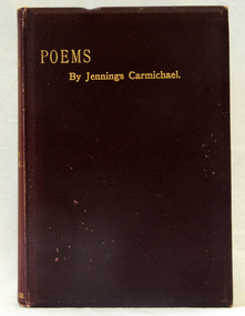
book, Ballantyne, Hanson & Co, Poems, 1895
Grace Elizabeth Jennings Carmichael (1867-1904), poet and nurse, was born on 24 February 1867 at Ballarat, Victoria, daughter of Archibald Carmichael, a miner from Perthshire, Scotland, and his wife Margaret Jennings, née Clark, from Cornwall, England. . About 1880 the family moved to Gippsland where Henderson managed a station near Orbost. Grace learned to love the Gippsland forest. She began to express in verse her understanding of the sights, scents and sounds of the bush, often writing in some remote clearing, her manuscripts stored for privacy in a hollow trunk. The Bairnsdale Advertiser published her first story, and the Weekly Times an early poem; then on 28 November 1885 her poem 'The Old Maid' was published in the Australasian under her pen name Jennings Carmichael. Encouraged by its editor, David Watterston, Grace sent nearly all her subsequent verse to that newspaper. (Read more by Lindsay Gardiner in Australian Dictionary of Biography.) This is a useful collection of the poetry of Jennings Carmichael, a leading Australian poet who spent much of her childhood in Orbost.A 212 pp cloth bound book with a dark purple cover and gold print on the spine and front - "Poems by Jennings Carmichael".Inside cover.carmichael-jennings literature poetry -
 City of Moorabbin Historical Society (Operating the Box Cottage Museum)
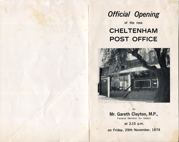
Document - Program Official Opening Cheltenham Post Office, Government Printer, 1974
John Hitchen was the manager of the first Cheltenham Post Office that opened 1/8/1857 in a boot and shoe store. Mail was transported to and from St Kilda to Cheltenham by coach 6 days a week and an additional service twice weekly to Tootgarook via Frankston also by coach. 1868 Post office Savings Bank began operation and the Telegraph office was established at the Railway Station 1885. A new building was built 1891 in Point Nepean Road for the official Cheltenham Post Office and a new manual telephone exchange began 1899 with 24 subscribers. By 1909 100 subscribers, 1951 there were 1700 and in 1974 12,000 subscribers . Hence this new building was designed by Oscar A. T. Gimsey & Assoc. and built by T W Morris & Sons Mordialloc. Mr G Clayton Federal MP Isaacs, opened the Post Office with Moorabbin City Council Mayor C.R McHutchison, Mr WJB Pollock, Director Posts and Telegraphs, and hands the Key of the post Office to Mr L De Longville Postmaster.The Post Office was an integral part to the development and prosperity of the Cheltenham area as the area grew from pioneer settlers in the 1850's to flourishing market gardens c1900 and industrial diversity of 1974.Program for the 'Official Opening of the Cheltenham Post Office' November 29th 1974 with a black and white photo of the building.city of moorabbin, county of bourke, moorabbin roads board, parish of moorabbin, shire of moorabbin, henry dendy's special survey 1841, were j.b., bent thomas, o'shannassy john, king richard, charman s, highett william, ormond francis, maynard dennis, post office, telegraph, st kilda station, tootgarook, frankston, clayton g mhr, mchutchison r.p mayor, pollock w j b mp, market gardens, early settlers, horse coach, de longville l postmaster -
 Sunshine and District Historical Society Incorporated
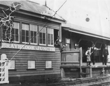
Photograph (1905), BRAYBROOK JUNCTION STATION
The Braybrook Junction railway station was opened on 7th September 1885 at the junction of the railway lines to Ballarat and to Bendigo. In 1904 H. V. McKay purchased the Braybrook Implement Works nearby, and in 1906 he moved his Sunshine Harvester Works agricultural machinery business from Ballarat to Braybrook Junction. In 1907 the station and township were renamed Sunshine after the Sunshine Harvester Works. On 20 April 1908 (Easter Monday), Sunshine station was the scene of the biggest train disaster in Victoria, when 44 people were killed and 400 injured from the 1100 people that were aboard the two trains. A Melbourne bound train from Bendigo collided with the rear of a train from Ballarat. There is a memorial plaque on platform 1 at the present Sunshine station. Sunshine station has recently been undergoing a complete rebuild. On 20 January 2014 the station, although not yet completed, was opened for train use, after being closed for several weeks.This photograph is significant because it is a reminder that the present Sunshine station and the nearby area were once named Braybrook Junction. It also shows what the Station, the Signal Box, and the station personnel looked like in circa 1905.Monochrome photograph showing Braybrook Junction Station and the Signal Box, plus station personnel. One of the personnel is holding a 'Staff' which was actually the authority for the train to proceed to the next Station or Signal Box. Photograph has substantial crazing in the upper left corner, a long diagonal crease, and dog eared corners.BRAYBROOK JUNCTNbraybrook junction station, railway, sunshine, train, transport, 1905, 1907, 1908, 7 september 1885 -
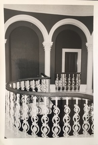
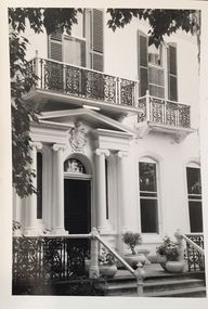
 Kew Historical Society Inc
Photograph - 'Butleigh Wooton', 867 Glenferrie Road, John T Collins, 1979
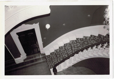
in 1882 Thomas Maidment paid the Society of Jesus £5,750 for nine allotments along Barkly Road (now Glenferrie Road). Maidment, who had arrived in Australia from the Glastonbury district in England in 1858, owned and managed a number of sheep stations in Victoria and subsequently became an '... eminently respectable ...' member of District society. In 1883 the Rate Books list Maidment's land in Barkly Road as the 'Buxton Hill Estate' and it was given an N.A.V. of £90, while in the following year his property attracted an N.A.V. of £160, suggesting that substantial improvements were taking place. Maidment's two-storey mansion, named 'Butleigh Wooton' after his birth-place in England, was completed in 1885 and was given an initial N.A.V. of £420. While Maidrnent is recorded as the owner of the building until at least 1896, Jane Maidment, his wife, continued the family ownership of the twenty-six roomed house with its extensive grounds until at least 1910. (Sanderson P. City of Kew Urban Conservation Study Vol 2)Butleigh Wooton is a substantial two storeyed house built in the Italianate style common in the 1880s. Its walls are rendered and it has limited applied decoration that includes brackets to the eaves line and engaged ionic columns under a broken pediment over the front entrance. The bowed window unit is of particular distinction and is not at all typical of this type of building. This interior by John T Collins is a view of the staircase from the first floor landing. (Sanderson P. City of Kew Urban Conservation Study Vol 2)Reverse: "JOHN COLLINS / 11 Anderson Road / Hawthorn East, 3123 / Film 395 Exposure 27A / Kew / Butleigh Wooton / Looking down on stairs / 8-4-79thomas maidment, butleigh wooton, 867 glenferrie road -- kew (vic.) -
 Kew Historical Society Inc
Photograph - 'Butleigh Wooton', 867 Glenferrie Road, John T Collins, 1979
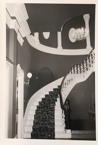
in 1882 Thomas Maidment paid the Society of Jesus £5,750 for nine allotments along Barkly Road (now Glenferrie Road). Maidment, who had arrived in Australia from the Glastonbury district in England in 1858, owned and managed a number of sheep stations in Victoria and subsequently became an '... eminently respectable ...' member of District society. In 1883 the Rate Books list Maidment's land in Barkly Road as the 'Buxton Hill Estate' and it was given an N.A.V. of £90, while in the following year his property attracted an N.A.V. of £160, suggesting that substantial improvements were taking place. Maidment's two-storey mansion, named 'Butleigh Wooton' after his birth-place in England, was completed in 1885 and was given an initial N.A.V. of £420. While Maidrnent is recorded as the owner of the building until at least 1896, Jane Maidment, his wife, continued the family ownership of the twenty-six roomed house with its extensive grounds until at least 1910. (Sanderson P. City of Kew Urban Conservation Study Vol 2)Butleigh Wooton is a substantial two storeyed house built in the Italianate style common in the 1880s. Its walls are rendered and it has limited applied decoration that includes brackets to the eaves line and engaged ionic columns under a broken pediment over the front entrance. The bowed window unit is of particular distinction and is not at all typical of this type of building. This interior by John T Collins is a view of the staircase from the first floor landing. (Sanderson P. City of Kew Urban Conservation Study Vol 2)Reverse: "JOHN COLLINS / 11 Anderson Road / Hawthorn East, 3123 / Film 395 Exposure 21A / Kew / Butleigh Wooton / Staircase / 8-4-79thomas maidment, butleigh wooton, 867 glenferrie road -- kew (vic.), john t collins -
 Kew Historical Society Inc
Photograph - 'Butleigh Wooton', 867 Glenferrie Road, John T Collins, 1979
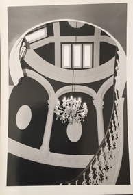
in 1882 Thomas Maidment paid the Society of Jesus £5,750 for nine allotments along Barkly Road (now Glenferrie Road). Maidment, who had arrived in Australia from the Glastonbury district in England in 1858, owned and managed a number of sheep stations in Victoria and subsequently became an '... eminently respectable ...' member of District society. In 1883 the Rate Books list Maidment's land in Barkly Road as the 'Buxton Hill Estate' and it was given an N.A.V. of £90, while in the following year his property attracted an N.A.V. of £160, suggesting that substantial improvements were taking place. Maidment's two-storey mansion, named 'Butleigh Wooton' after his birth-place in England, was completed in 1885 and was given an initial N.A.V. of £420. While Maidrnent is recorded as the owner of the building until at least 1896, Jane Maidment, his wife, continued the family ownership of the twenty-six roomed house with its extensive grounds until at least 1910. (Sanderson P. City of Kew Urban Conservation Study Vol 2)Butleigh Wooton is a substantial two storeyed house built in the Italianate style common in the 1880s. Its walls are rendered and it has limited applied decoration that includes brackets to the eaves line and engaged ionic columns under a broken pediment over the front entrance. The bowed window unit is of particular distinction and is not at all typical of this type of building. This interior by John T Collins is a view of the staircase from the first floor landing. (Sanderson P. City of Kew Urban Conservation Study Vol 2)Reverse: "JOHN COLLINS / 11 Anderson Road / Hawthorn East, 3123 / Film 395 Exposure 21A / Kew / Butleigh Wooton / Staircase looking up to dome / 8-4-79thomas maidment, butleigh wooton, 867 glenferrie road -- kew (vic.), john t collins -
 Kew Historical Society Inc
Photograph - 'Butleigh Wooton', 867 Glenferrie Road, John T Collins, 1979
in 1882 Thomas Maidment paid the Society of Jesus £5,750 for nine allotments along Barkly Road (now Glenferrie Road). Maidment, who had arrived in Australia from the Glastonbury district in England in 1858, owned and managed a number of sheep stations in Victoria and subsequently became an '... eminently respectable ...' member of District society. In 1883 the Rate Books list Maidment's land in Barkly Road as the 'Buxton Hill Estate' and it was given an N.A.V. of £90, while in the following year his property attracted an N.A.V. of £160, suggesting that substantial improvements were taking place. Maidment's two-storey mansion, named 'Butleigh Wooton' after his birth-place in England, was completed in 1885 and was given an initial N.A.V. of £420. While Maidrnent is recorded as the owner of the building until at least 1896, Jane Maidment, his wife, continued the family ownership of the twenty-six roomed house with its extensive grounds until at least 1910. (Sanderson P. City of Kew Urban Conservation Study Vol 2)Butleigh Wooton is a substantial two storeyed house built in the Italianate style common in the 1880s. Its walls are rendered and it has limited applied decoration that includes brackets to the eaves line and engaged ionic columns under a broken pediment over the front entrance. The bowed window unit is of particular distinction and is not at all typical of this type of building. This interior by John T Collins is a view of the staircase from the first floor landing. (Sanderson P. City of Kew Urban Conservation Study Vol 2)Reverse: "JOHN COLLINS / 11 Anderson Road / Hawthorn East, 3123 / Film 395 Exposure 21A / Kew / Butleigh Wooton / Railing at head of stairs / 8-4-79thomas maidment, butleigh wooton, 867 glenferrie road -- kew (vic.), john t collins -
 Kew Historical Society Inc
Photograph - 'Butleigh Wooton', 867 Glenferrie Road, John T Collins, 1979
in 1882 Thomas Maidment paid the Society of Jesus £5,750 for nine allotments along Barkly Road (now Glenferrie Road). Maidment, who had arrived in Australia from the Glastonbury district in England in 1858, owned and managed a number of sheep stations in Victoria and subsequently became an '... eminently respectable ...' member of District society. In 1883 the Rate Books list Maidment's land in Barkly Road as the 'Buxton Hill Estate' and it was given an N.A.V. of £90, while in the following year his property attracted an N.A.V. of £160, suggesting that substantial improvements were taking place. Maidment's two-storey mansion, named 'Butleigh Wooton' after his birth-place in England, was completed in 1885 and was given an initial N.A.V. of £420. While Maidrnent is recorded as the owner of the building until at least 1896, Jane Maidment, his wife, continued the family ownership of the twenty-six roomed house with its extensive grounds until at least 1910. (Sanderson P. City of Kew Urban Conservation Study Vol 2)Butleigh Wooton is a substantial two storeyed house built in the Italianate style common in the 1880s. Its walls are rendered and it has limited applied decoration that includes brackets to the eaves line and engaged ionic columns under a broken pediment over the front entrance. The bowed window unit is of particular distinction and is not at all typical of this type of building. This interior by John T Collins is a view of the staircase from the first floor landing. (Sanderson P. City of Kew Urban Conservation Study Vol 2)Reverse: "JOHN COLLINS / 11 Anderson Road / Hawthorn East, 3123 / Film 395 Exposure 21A / Kew / Butleigh Wooton / Entrance / 8-4-79thomas maidment, butleigh wooton, 867 glenferrie road -- kew (vic.), john t collins -
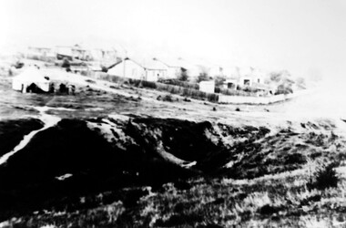
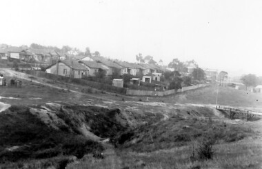 Surrey Hills Historical Society Collection
Photograph, Back Creek (later South Surrey Park), c 1936, 1936
This photo was taken at the opening of the footbridge by Sir Winston Dugan in 1936.South Surrey Park was developed on land which had been the property of the Kleinert family. Their land extended from Union Road to Essex Road. They ran horses, ducks and fowls and Emily Kleinert grew flowers. Alan Holt research: Lot 6 was sold to Martin Klienert by Karl Richter in 1860 together with a portion of another adjacent lot. From 1860-1885 Martin worked it as a market garden leasing some land for grazing when it was not required for gardening. He died in 1898. In a formal document, William declared he was the son of Martin "who purchased land in 1860, died in 1898 and the land has been continually occupied by father and family since. It has been cultivated as a market garden; when not being used for gardening it was let for cultivation and grazing." William died in 1939 and the property passed to his sons Martin and Ernest. The family sold the land to the Camberwell Council in the 1950s.This photo is significant as it shows the transition from rural to urban land use in Surrey Hills.Black and white photo taken in the area later known as South Surrey Park. Back Creek is in the foreground. There is a tent on the LHS and approximately 7 houses which front Verdun Street. Some of their backyards face onto the open space along the creek bed.parks and reserves, creeks, south surrey park, civic occasion, official events, back creek, verdun street, 1936, kleinert family, sir winston dugan, topography -
 Surrey Hills Historical Society Collection
Photograph, Footbridge across Back Creek, 1980, 1980
South Surrey Park was developed on land which had been the property of the Kleinert family. Their land extended from Union Road to Essex Road. They ran horses, ducks and fowls and Emily Kleinert grew flowers. Alan Holt research: Lot 6 was sold to Martin Klienert by Karl Richter in 1860 together with a portion of another adjacent lot. From 1860-1885 Martin worked it as a market garden leasing some land for grazing when it was not required for gardening. He died in 1898. In a formal document, William declared he was the son of Martin "who purchased land in 1860, died in 1898 and the land has been continually occupied by father and family since. It has been cultivated as a market garden; when not being used for gardening it was let for cultivation and grazing." William died in 1939 and the property passed to his sons Martin and Ernest. The family sold the land to the Camberwell Council in the 1950s. The original footbridge was opened by Sir Winston Dugan in 1936.Black and white photo of a wooden footbridge with large trees and shrubs obscuring its surrounds.parks and reserves, creeks, south surrey park, back creek, verdun street, footbridges -
 Wodonga & District Historical Society Inc
Domestic object - Vintage Crumb Scraper Set
This item is from a collection donated by descendants of John Francis Turner of Wodonga. Mr. Turner was born on 6 June 1885. He completed all of his schooling at Scotts Boarding School in Albury, New South Wales. On leaving school, he was employed at Dalgety’s, Albury as an auctioneer. In 1924 John was promoted to Manager of the Wodonga Branch of Dalgety’s. On 15/03/1900 he married Beatrice Neal (born 7/12/1887 and died 7/2/1953) from Collingwood, Victoria. They had 4 daughters – Francis (Nancy), Heather, Jessie and Mary. In 1920, the family moved From Albury to Wodonga, purchasing their family home “Locherbie” at 169 High Street, Wodonga. "Locherbie" still stands in Wodonga in 2022. The collection contains items used by the Turner family during their life in Wodonga. A table scraper or sweeper was used in households and fine dining situations to ensure crumbs and small pieces of food could be easily and quickly removed.This item comes from a collection used by a prominent citizen of Wodonga. It is also an excellent example of domestic items used in the early 20th century.A small tray and scraper designed to sweep stray crumbs and bits of food off tabletops. This set has a kookaburra design on each piece,table crumber, dining items, domestic utensils -
 Surrey Hills Historical Society Collection
Photograph, Holy Trinity Tennis Club, 1941, 1941
Holy Trinity originally held their first organised services during 1885 in the recreation hall in Albany Crescent, Surrey Hills with the Reverend H E Taylor, then Vicar of St Barnabas, Balwyn, conducting the services. Mr E D Dyer donated the land for a church on the corner of Mont Albert Road and St George's Road, Mont Albert with the foundation stone being laid on 17 July 1886. The first church service was held on Sunday, January 30, 1887 with eighty people present. A new site on Union Road, Surrey Hills was acquired (lots 3 & 4) and a wooden church was erected and opened in 1907 on lot 4. It became known as Holy Trinity Surrey Hills. In November 1939 two tennis courts and a pavilion were erected on land acquired by the parish in a lane off Balmoral Crescent. The Holy Trinity Tennis Club had 80 years of distinguished success in match play until it closed in 2014. That land was sold in 2015 and the parish's real estate holdings diversified.Black and white photo of 9 ladies, in tennis dresses and shoes, and 8 men, also in tennis attire. They are posed next to a light coloured building on the right and a paling fence along the back left side. There are 5 men standing at back, 6 ladies and 1 man standing in the next row, 4 ladies sitting in front and 2 men sitting on the ground. Three ladies sitting are holding tennis racquets. There are trees behind the paling fence. Black and white photo mounted on card; photo measures W 11.1 cm x H 6.7 cm.sporting clubs, sports people, tennis, holy trinity anglican church, 1940 - 1949, mrs mary clucas -
 Bacchus Marsh & District Historical Society
Photograph, Stone Villa house 4 Bennett Street Bacchus Marsh 1883
The house depicted in this image was constructed in 1865 for James Young a prominent local businessman and participant in community affairs. James Young left Bacchus Marsh in 1869. In 1870 Stone Villa was purchased by local solicitor Francis Gell. In 1872 it was bought by William Collyer. For a time before 1883 it was used as a school operated by Mr Thomas Kissock and his wife. From 1883 until 1922 it was used as a parsonage by the Church of England. In 1922 it was sold to Frederick Slack as a private residence. Since Slack's ownership there have been other owners. As of April 2024 it remains as a private residence and is listed as a heritage property in the Moorabool Shire planning scheme. The identity of the two women and young girl in the foreground of the image has not been established. One of the women, and the child are possibly the wife and daughter of the Rev A.C. McCausland who was the Church of England Vicar in Bacchus Marsh from 1872 until 1885 and would have resided in this house in 1883 when this picture was produced.An early visual record of one of the most culturally and architecturally significant nineteenth century stone houses in Bacchus Marsh.Small sepia 'carte de visite' style unframed photograph on card with gold border framing photograph. Housed in the album, 'Photographs of Bacchus Marsh and District in 1883 by Stevenson and McNicoll', the Jeremeas Family Album. The photo is of a stone dwelling with an ornate gable above the inset front door which is flanked by two double windows, one of which is a bay window. The gable roof line bears ornate woodwork. A weatherboard extension with verandah has been added to the rear of the house, running north-south. A picket fence lines the block to the side of the dwelling. Two elegantly dressed women, both holding a furled umbrella, stand at the front, one holding the hand of a little girl.Printed On the front: Stevenson & McNicoll. Photo. 108 Elizabeth St. Melbourne. COPIES CAN BE OBTAINED AT ANY TIME. On the back: LIGHT & TRUTH inscribed on a banner surmounted by a representation of the rising sun. Copies of this Portrait can be had at any time by sending the Name and Post Office Money Order or Stamps for the amount of order to STEVENSON & McNICOLL LATE BENSON & STEVENSON, Photographers. 108 Elizabeth Street, MELBOURNE. Hand written on the reverse: 'Stone Villa built by James Young 1860 (sic) as his private residence, later as a school (Mr and Mrs Kissock proprietors) bought by CofE for Vicarage 1883-1922. Courtesy of Mrs J Jeremeas, Photo 1883' james young 1816-1871, houses, stone villa bacchus marsh, clergy residences, bacchus marsh vic. history, schools bacchus marsh, stevenson and mcnicoll 1883 photographs of bacchus marsh and district -
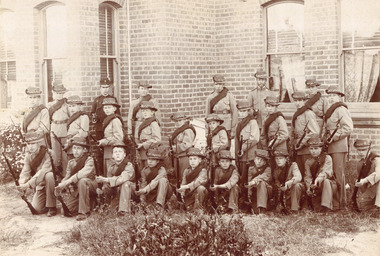 Surrey Hills Historical Society Collection
Photograph - Surrey College Cadet Corps, 1899, 1899
Surrey College was opened in early 1892 by Rev. Dr Frederick Darling who had been the first minister of the Presbyterian Church in Canterbury Road. He resigned this position to open the school which operated until 1908 with additional premises at 12 Vincent Street. The school had 40 boarders as well as day boys. Courses included algebra, euclid, history, typewriting, shorthand and drill. In the 1930s, Nethercourt Private Hospital took over the site. Later it became St Jude's Hospital. land in front of the building was subdivided off in the 1970s. The building is still extant as a private dwelling with York Street, Surrey Hills as the address. This is one of 3 photos donated by Susan Hobbs, whose grandfather Rev. George Edward Downton is thought to have been a student at the college. George E. Downton was born in Avoca in 1885. He was later a missionary in New Guinea and Secretary to the Australian Board of Missions in Adelaide. He died in 1926 or 1927. Sepia photo of 26 men and boys dressed in military uniform, many holding rifles. They are standing in front of a brick building with bay windows with blinds and curtains. There is a clump of foliage and grass in front of boys. "Surrey College - Surrey Hills / Principal: Rev Frdk. A. Darling, Melb. Univ./Cadet Corps, 1899." On the mount below the photo. Inscription on bottom right hand corner of photo: "Prepare for cavalry"schools, 1899, surrey hills, surrey college, rev frederick a darling, george edward downton, susan hobbs, union road, nethercourt hospital, st jude's hospital, 219-223 union road, cadet corps, 1890-1899 -
 Kew Historical Society Inc
Photograph, Charles Nettleton, Kew Lunatic Asylum, c.1886
Following a Royal Commission in 1854, the building of a new Asylum at Kew began in 1864. It was built to replace the Yarra Bend Asylum on the Fairfield side of the Yarra River. Work started in 1864 and was completed in 1872 at a cost of ₤198,334. Operating over a period of 116 years, and often renamed to take account of public sensitivities, the ‘Kew Lunatic Asylum’ was one of the largest asylums built in Australia. ‘Willsmere’ was finally closed in December 1988 and sold by the Government of Victoria in the late 1980s. The photograph is by Charles Nettleton. He arrived in Victoria in 1854. In Melbourne he joined the studio of T. Duryea and Alexander McDonald and specialized in outdoor work. ... Nettleton opened his own studio in 1858. His souvenir albums were the first of the type to be offered to the public. However, when the dry-plate came into general use in 1885 he knew that the new process offered opportunities that were beyond his scope. Five years later his studio was closed (Source: ADB)A rare silver albumen photograph by the Victorian photographer Charles Nettleton.A framed original silver albumen photograph by Charles Nettleton showing the front of the Kew Lunatic Asylum.KEW LUNATIC ASYLUMkew lunatic asylum, studley park, charles nettleton, asylum, willsmere hospital, willsmere mental hospital, lunatic -
 Marysville & District Historical Society
Postcard (item) - Colour postcard, Nicholas John Caire, Brook Scene at Marysville, 1906
An early colour postcard of a brook scene in Marysville. The original photograph was taken by Nicholas John Caire in 1906. This is one of a series of postcards of photographs taken by socialite photographer Nicholas John Caire. N.J. Caire had a great love for the area and in the late 1800's took many photographs of Marysville and its surrounds. N.J. Caire was born in 1837 in Guernsey. He arrived in Adelaide about 1860 along with his parents who encouraged his early interest in photography. He opened a studio in Adelaide in 1867 after traveling extensively throughout the Gippsland taking photographs. After marrying in 1870 he moved to Talbot in Victoria until 1876 when he opened a studio in the Royal Arcade in Melbourne. After 1885 N.J. Caire gave up his city work and made his home in South Yarra and devoted the rest of his life to outdoor photography, specializing in the bush, the gullies and the mountains of south-eastern Victoria. An early colour postcard of a brook scene in Marysville. The original photograph was taken by Nicholas John Caire in 1906.POST CARD This Space may be used for Correspondence. (FOR ADDRESS ONLY) Postmark/ Geelong/ 22/ Rest is illegible Glad to know you/ are keeping better/ & trust you will go/ on so doing accept/ love & best wishes/ for a happy Xmas/ we will be all/ thinking of you/ Yours M.P. Philip Mip Rittocto/ "Hospital"/ Lt Ryrie St/ Geelongmarysville, victoria, nicholas john caire, brook scene, souvenir, postcard -
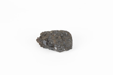 The Beechworth Burke Museum
Geological specimen - Garnet crystals in galena, Unknown
Majority of Galena in Australia is found in hydrothermal deposits emplaced around 1680 million years ago which have been heavily metamorphosed. Galena is the natural mineral form of lead sulfaide. It occurs generally as fine to large crystals due to syntectonic remobilization at low temperatures and moves to a suitable location. The colour is a shining lead and silvery gray with high specific gravity between 7.2 and 7.6 gms/cm3 and contains 86.6 lead sulfaide in its purest form. Its cyrstal system is cubic with perfect cleavages, and contract penetration and lamellar twinning. This particular specimen is from the Broken Hill mine, it is one of the largest lead mines located in Western New South Wales and still has ore reserves amounting to 20.9 million tonnes of ore grading of 7.4% lead, 9.4% zinc, and 61.5 million oz of Silver. Throughout its history, it has produced over 200 million tonnes of ore throughout its 127 years of mining history dating back to 1885. Galena mineral ore found in Australia is considered rare, as it is only currently found in the Broken Hill Mine of Western New South Wales. It represents heritage value through the systematic collecting of the geological surveyers in Victoria and Australia during the early to late 19th Century. The fact that it is only found in one mining area of Australia, shows that this specimen is rare for examples of Australian Galena. This mineral specimen is one part to a larger collection, aquistion, and distribution of Garnet in Galena around Australia and parts of the world and donated to the Burke Museum between 1860-1880. While this specimen was not found by the Victorian Geological Survey, it shows the historical need for mapping geological areas around the Gold Rush region to further identify areas of precious metal and gem aquisition. Additionally, collecting these specimens was an important part of mapping the scientific make up of the earth's surface. Many were sent to institutions for further contribution to research and scientific knowledge of the specimens. A solid coin-sized lead and zinc sulphaide and zinc silicate ore mineral in shades of black and red with shiny black points. GARNET CRYSTALS in / GALENA (lead sulphide), / SPALERITE (zinc sulphide), / WILLEMITE (zinc silicate) ore. / Locality: Broken Hill, NSWburke museum, #beechworth, indigo shire, beechworth museum, geological, geological specimen, mineral, galena, galena quartz, broken hill mine, broken hill, nsw -
Surrey Hills Historical Society Collection
Photograph - Surrey College staff and boarders, 1899, 1899
Surrey College was opened in early 1892 by Rev. Dr Frederick Darling who had been the first minister of the Presbyterian Church in Canterbury Road. He resigned this position to open the school which operated until 1908 with additional premises at 12 Vincent Street. The school had 40 boarders as well as day boys. Courses included algebra, euclid, history, typewriting, shorthand and drill. In the 1930s, Nethercourt Private Hospital took over the site. Later it became St Jude's Hospital. land in front of the building was subdivided off in the 1970s. The building is still extant as a private dwelling with York Street, Surrey Hills as the address. This is one of 3 photos donated by Susan Hobbs, whose grandfather Rev. George Edward Downton is thought to have been a student at the college. George E. Downton was born in Avoca in 1885. He was later a missionary in New Guinea and Secretary to the Australian Board of Missions in Adelaide. He died in 1926 or 1927. Sepia photo of 26 men and boys and one female against a background of a two-storey brick building. This is the rear of the Surrey College. There are 4 additional figures in the background and an additional house can be seen beyond the property boundary. Many of the boys wear or hold caps or boaters. The 2 men in the back row on the right are wearing academic gowns and mortar boards. The gentleman with the beard on the end is Rev. Frederick Darling, the Principal of the college. Sepia photo on cream mount board. Note that the photo is detached from the mount, so the photo is numbered SHP2025.15.1 and the mount as SHP2025.15.2.Front: "Surrey College - Surrey Hills / Principal: Rev. Fredk. A. DARLING, Melb. Univ./STAFF AND BOARDERS, 1899." Back: "York Street, Surrey Hills" in grey lead pencil; possibly Susan John's hand. Back, bottom LH corner: "L. Johnstone" Back, top RH corner: "5621" - this was the registration number used by box Hill historical society Middle back: Purple stamp - "Tennent/Photographer / 110 Johnstone Street / Collingwood" schools, 1899, surrey hills, surrey college, rev frederick a darling, george edward downton, susan hobbs, union road, nethercourt hospital, st jude's hospital, 219-223 union road, 1890-1899, york street -
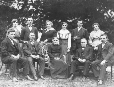 Ringwood and District Historical Society
Photograph, W Blood and Family,1920
Black and white photograph of family group (2 copies)Written on rear of backing sheet: "W. Blood and family, 1920. Back - Evelyn (Mrs. Skead), Stan, Annie (Gerlach), Edie (Sharp), Ern, Alice (Meyland). Front - Arthur, William, Mrs. B., Mr. B., George. Ern, last of family, died visiting Ringwood from Sydney 13th April, 1970. First visit for over 40 years. William Blood, born Adelaide, 1847. Married Emma Ainger at Nunawading 25th September 1872. Children: Annie 1875, William 1876, Frank 1878, Arthur 1880, Herbert 1881, Alice 1884, Ernest 1886, Edith 1889, Evaleen 1891, Stanley 1893. Herbert died Aug. 1885, int. Box Hill." -
 Kew Historical Society Inc
Plan, Melbourne & Metropolitan Board of Works. Borough of Kew Detail Plan No.1579, 1904
The Melbourne and Metropolitan Board of Works (MMBW) plans were produced from the 1890s to the 1950s. They were crucial to the design and development of Melbourne's sewerage and drainage system. The plans, at a scale of 40 feet to 1 inch (1:480), provide a detailed historical record of Melbourne streetscapes and environmental features. Each plan covers one or two street blocks (roughly six streets), showing details of buildings, including garden layouts and ownership boundaries, and features such as laneways, drains, bridges, parks, municipal boundaries and other prominent landmarks as they existed at the time each plan was produced. (Source: State Library of Victoria). This plan forms part of a large group of MMBW plans and maps that was donated to the Society by the Mr Poulter, City Engineer of the City of Kew in 1989. Within this collection, thirty-five hand-coloured plans, backed with linen, are of statewide significance as they include annotations that provide details of construction materials used in buildings in the first decade of the 20th century as well as additional information about land ownership and usage. The copies in the Public Record Office Victoria and the State Library of Victoria are monochrome versions which do not denote building materials so that the maps in this collection are invaluable and unique tools for researchers and heritage consultants. A number of the plans are not held in the collection of the State Library of Victoria so they have the additional attribute of rarity.Original survey plan, issued by the MMBW to a contractor with responsibility for constructing sewers in the area identified on the plan within the Borough of Kew. The plan was at some stage hand-coloured, possibly by the contractor, but more likely by officers working in the Engineering Department of the Borough and later Town, then City of Kew. The hand-coloured sections of buildings on the plan were used to denote masonry or brick constructions (pink), weatherboard constructions (yellow), and public buildings (grey). While MMBW Plan No.1579 does not include many buildings, those that it does show are significant to Kew’s history. These include the ‘Kew [Railway] Station’ in Denmark Street and the ‘Recreation Hall’ and rear courts off Wellington Street. The plan shows the outline of the Recreation Hall, constructed in 1880, at the rear of which is listed a bowling green, two tennis courts, a ‘skittle alley’ and a pavilion. When the Hall was first built, the Kew Cricket Club occupied an adjacent ground, however in 1885 this was acquired by the State Government as the future location of the Kew Railway Station. The Plan also shows a single oval at Xavier College. This oval was completed in 1883. One of the current ovals conforms to this oval’s original shape and position in the school grounds.melbourne and metropolitan board of works, detail plans, maps - borough of kew, mmbw 1579, cartography -
 Kew Historical Society Inc
Plan, Melbourne & Metropolitan Board of Works : Borough of Kew : Detail Plan No.1572, 1905
The Melbourne and Metropolitan Board of Works (MMBW) plans were produced from the 1890s to the 1950s. They were crucial to the design and development of Melbourne's sewerage and drainage system. The plans, at a scale of 40 feet to 1 inch (1:480), provide a detailed historical record of Melbourne streetscapes and environmental features. Each plan covers one or two street blocks (roughly six streets), showing details of buildings, including garden layouts and ownership boundaries, and features such as laneways, drains, bridges, parks, municipal boundaries and other prominent landmarks as they existed at the time each plan was produced. (Source: State Library of Victoria)This plan forms part of a large group of MMBW plans and maps that was donated to the Society by the Mr Poulter, City Engineer of the City of Kew in 1989. Within this collection, thirty-five hand-coloured plans, backed with linen, are of statewide significance as they include annotations that provide details of construction materials used in buildings in the first decade of the 20th century as well as additional information about land ownership and usage. The copies in the Public Record Office Victoria and the State Library of Victoria are monochrome versions which do not denote building materials so that the maps in this collection are invaluable and unique tools for researchers and heritage consultants. A number of the plans are not held in the collection of the State Library of Victoria so they have the additional attribute of rarity.Original survey plan, issued by the MMBW to a contractor with responsibility for constructing sewers in the area identified on the plan within the Borough of Kew. The plan was at some stage hand-coloured, possibly by the contractor, but more likely by officers working in the Engineering Department of the Borough and later Town, then City of Kew. The hand-coloured sections of buildings on the plan were used to denote masonry or brick constructions (pink), weatherboard constructions (yellow), and public buildings (grey). Plan No. 1572 represents the built environment bordered by Barkers Road, Wrixon Street, Edgevale Road and Fitzwilliam Street. Other streets identified on the plan include Stansell Street. Plan 1572 shows that by 1903-05, there was only patchy development in this area of Kew, mainly on Edgevale Road and Fitzwilliam Street. Only two named houses are identified: the quaintly named ‘Tweed Cottage’, and ‘Mendip’. The earliest reference to Treed Cottage in Australian newspapers is to the death of Walter Thompson, aged 74 who was a resident there in 1885. His youngest daughter was to die there in 1908. Mendip to the north of Tweed Cottage was owned by Henry Thompson; he was to die in 1901; his wife in 1932. At this period of time, Malin Street and Clivedon Court did not extend to Barkers Road.melbourne and metropolitan board of works, detail plans, mmbw 1572, cartography -
Clunes Museum
Work on paper - FAMILY HISTORY BENJAMIN WHITE
BENJAMIN AND SARAH WHITE ARE RECORDED IN "SOUTH AUSTRALIANS 1836-1885" BOOK TWO.DESMA FAY NICHOLSON OF 160 FRANCIS ST RICHMOND NSW PROVIDED THE INFORMATION FOR THE BOOK. DESMA IS A DESCENDENT OF JOHN WHITE, FIFTH AND YOUNGEST SON OF BENJAMIN WHITE BENJAMIN WHITE PARENTS BENJAMIN AND JANE (NEE LOWDEN- SHOULD BE SOWDEN) BORN 1819 CAMBORNE, CORNWALL DIED JAN 1874 VICTORIA, BURIED IN CRESWICK ARRIVED SA 29/10/1847 FROM ENGLAND ON DUCHESS OF NORTHUMBERLAND DEPARTED SA C. 1852 FOR VICTORIA OVERLAND OCCUPATION MINER AND SECTON RESIDENCE: KAPUNDA ALLENS CREEK SA RELIGION: WESLEYAN HE MARRIED SARAH (SALLY) BAILEY ON 02/08/1845 IN CAMBORNE ENGLAND, SHE DIED 12/08/1891 IN CRESWICK CHILDREN: SARAH ANNE WILLIAMS 07/09/1845 TO 18/06/1890 ELIZABETH ORRINGE 22/02/1847 TO 16/10/1920 BENJAMIN 22/04/1849 TO 19/02/1889 HARRIET 29/08/1850 TO 15/05/1851 WILLIAM BAILEY 22/10/1851 TO 14/03/1916 JOSEPH 20/11/1853 TO 17/05/1910 THOMAS HENRY 15/05/1855 TO 15/08/1917 JOHN 14/04/1857 TO 27/02/1935 HARRIET 17/01/1860 TO 14/06/1863 DECIMA JANE CHEGWYN 04/01/1862 TO 28/02/1940 EMILY WILSON 07/03/1864 TO 19/08/1937 BENJAMIN WHITE MARRIED SARAH BAILEY IN CORNWALL IN SEPTEMBER 1845, JUST ONE MONTH BEFORE THE BIRTH OF THEIR FIRST CHILD SARAH ANN. SECOND CHILD ELIZABETH WAS BORN IN MARCH 1847 JUST SIX MONTHS BEFORE THE FAMILY SAILED FOR SOUTH AUSTRALIA ON THE NORTHUMBERLAND. THE MANNING INDEX OF SOUTH AUSTRALIAN HISTORY REC9ORDS THAT BENJAMIN WHITE WAS RESPONSIBLE FOR "CREATING" THE ALLEN CREEK VILLAGE 5 KM NORTHWEST OF KAPUNDA C. 1849. CERTAINLY AT ONE STAGE BENJAMIN HAD A CONSIDERABLE LAND HOLDING ADJACENT TO ALLEN'S CREEK VAL LAWRENCE SUGGESTS THAT THE WHITE FAMILY TRAVELLED BY SEA FROM SA TO VICTORIA, NOT OVERLAND AS SUGESTED BY DESMA NICHOLSON IN "SOUTH AUSTRALIANS 1836-1885 ACCORDING TO CRSWICK HOSPITAL RECORDS BENJAMIN WHITE WAS ADMITTED JUNE 27 1873 (AGE 49 MARRIED, GRAVEDIGGER AT CRESWICK, BORN IN ENGLAND, WESLEYAN) AND LEFT HOSPITAL JULY 14 1873. A CHRONICALLY ILL CONDITION WAS RELIEVED. BENJAMIN WHITE DIED DECEMBER 22, 1873. A SPECIAL CHURCH SERMON WAS CARRIED OUT ON SUNDAY JANUARY 43 1874benjamin white, sarah white, sarah bailey -
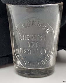 Flagstaff Hill Maritime Museum and Village
Container - Medicine Glass, W T & Co. (Whitall Tatum), late 19th Century to 1916
This medicine glass, or dose cup, was made for Mr. H. London, chemist and dentist, Warrnambool. His premises was at corner of Koroit and Liebig Streets, Warrnambool. The medicine glass has graduations on its side to measure doses of Teaspoon, Dessert Spoon and Tablespoon. It was donated by the family of Dr WR Angus of Warrnambool. The side seams and indented base of the glass, with the embossed lettering, show that it was produced in a three-piece mould, a method used in the late 19th and early 20th century. Mr H London was recorded in local newspaper articles from The Warrnambool Standard between 1885 to 1904. A further record in The Warrnambool Standard mentions Mr London, chemist, formerly of Warrnambool, as currently a chemist in Moore Street, Rochester. He was noted again in the Bendigo Advertiser in 1917. The maker, Whitall Tatum & Co, is clearly marked on the base of the bottle. The company was a well-known maker of prescription bottles. He used the brand "W. T. & Co". from Mid-1870's until the late 1880's, moulded into his glassware.This medicine glass is significant as an example of medical equipment that has a design still used today. It is also significant for its association with H London, a local Warrnambool chemist involved in the community and commerce of early 20th century in Warrnambool.Medicine glass or dose cup, c. 1916. Glass is a conical shape with inward sloping sides and a concave base. there are side seams and a concave base. Embossed inscriptions are on the glass, showing measurements in the imperial scale on one side , the owner's details are on the other side and the maker's details are on the base. Three horizontal lines are etched on the left of the measurements. The glass belonged to H. London, Chemist and Dentist, Warrnambool, and was made by Whitall Tatum & Co., U.S.A. The glass is part of the W R Angus Collection.On sides: "TABLE", "DESSERT", "TEA". "H LONDON / WARRNAMBOOL / CHEMIST AND DENTIST" On base: "W.T. & CO. / A.J. / U.S.A."flagstaff hill, warrnambool, shipwrecked coast, flagstaff hill maritime museum, maritime museum, shipwreck coast, flagstaff hill maritime village, great ocean road, dose cup, medicine glass, chemist, mdeical equipment, medicine, h. london, chemist and dentist, liegig st warrnambool, rochester, whitall tatum & co, w. t. & co., three-piece mould, w.r. angus