Showing 1201 items
matching commercial road
-
 Stawell Historical Society Inc
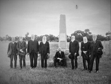
Photograph, "Peace" Memorial on Halls Gap Road built 1919 at site of old Treasury Building Commercial Street Pleasant Creek c1922
Group of Gentlemen beside the Peace Memorial situated on Halls Gap Road built 1919 at site of old Treasury Building Commercial Street Pleasant Creek. C1922stawell -
 Eltham District Historical Society Inc
Photograph - Digital Photograph, Marguerite Marshall, Sutherland Home for Children, Diamond Creek, 27 September 2007
The Sutherland Homes for Children on Yan Yean Road, Diamond Creek cared for thousands of children from when it was opened in 1912. The site closed for this purpose in 1991 and was sold and later developed for commercial and office purposes. Covered under Heritage Overlay, Nillumbik Planning Scheme. Published: Nillumbik Now and Then / Marguerite Marshall 2008; photographs Alan King with Marguerite Marshall.; p107This collection of almost 130 photos about places and people within the Shire of Nillumbik, an urban and rural municipality in Melbourne's north, contributes to an understanding of the history of the Shire. Published in 2008 immediately prior to the Black Saturday bushfires of February 7, 2009, it documents sites that were impacted, and in some cases destroyed by the fires. It includes photographs taken especially for the publication, creating a unique time capsule representing the Shire in the early 21st century. It remains the most recent comprehenesive publication devoted to the Shire's history connecting local residents to the past. nillumbik now and then (marshall-king) collection, diamond creek, sutherland home for children -
 Ararat & District Historical Society (operating the Langi Morgala Museum)
Postcard
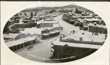
Black and white postcard of Barkly Street, Ararat. The photo is taken from the Town Hall. The Commercial Hotel and its balcony are pictured on the right while the zig zag of the main street looks like a dirt road.Addressed to Mr G. Mitchell, Collins St, Melbourne also a letter written on the back of the postcard -
 Glen Eira Historical Society
Photograph - Hawthorn Road, 342, Caulfield
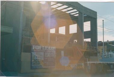
Two items about this address: 1/Two colour photos of a commercial building under construction on Hawthorn Road in September 1987. Building is south of Glenhuntly Road on western side And was being built for Caulfield City Council. 2/Print of comment entered 03/03/2019 on Victorian Collections website for this file from reader Angus giving street number as '342'. Google map photo print done 04/04/2019 confirms this.hawthorn road, caulfield, caulfield city council, commercial buildings, council buildings -
 Glen Eira Historical Society
Article - Hawthorn Road, 449, Caulfield South
One item on this address. An article and ads in PRW of 29/07/2011 about three new developments in Caulfield South. Included is a short history and description of the suburb. The projects are all on Hawthorn Road or Maple Street- Maple on the Park - a mixed use of developments Elle-luxury apartments Central Shule Chabad – new synagogue and community centrehawthorn road, caulfield south, land subdivision, shops, flats, caulfield primary school, towers, japanese school of melbourne, sporting clubs, mccubbin frederick, armadale bowls club, brighton cemetery, boyd arthur merricks, artists, bent sir thomas, premiers, bentleigh, bent street, jewish community, maple on the park, cbg architects, maple apartments, schacter max, property developers, century 21 wilson pride, real estate agents, elle, besser david, rosenwald yoel, amira gaby, harper terry, central shule chabad, synagogues, community centres, halls, beter-zionist youth movement, residential development, commercial development, eckstein joey, fein peter, liebowitz lionel, besser dion, butt rochelle -
Glen Eira Historical Society
Letter - Hawthorn Road, 566, Caulfield
Three paged letter dated 18/08/1980 from Food Plus Stores to City of Caulfield giving support factors re proposed redevelopment for a Food Plus Store corner of Hawthorn Road and North Road, South Caulfield. Current address is 566 Hawthorn Road, Caulfield.hawthorn road, caulfield, food stores plus, city of caulfield, petrol stations, shops, employment, commercial establishments -
Glen Eira Historical Society
Article - Brunning, Leslie Herbert Ashby
An extract about Brunning’s Nurseries, St Kilda, taken from John Butler Cooper’s The History of St Kilda, from its first settlement to a city and after 1840 to 1930, Vol II. The extract is a short history of Brunning’s Nurseries, St Kilda. Includes a handwritten note by Deborah Towns citing the source, dated 08/07/2011.brunning george, brunning george edward, brunning herbert, brunning’s nurseries, g brunning and sons, st kilda, brunning street, brighton road, gardening, st kilda council, agricultural industry, commercial establishment -
Glen Eira Historical Society
Document - GLEN EIRA ACTIVITY CENTRES
This file contains three items pertaining to the draft of the Glen Eira Activity Centre Strategy, each dated 11/2004 and composed by Peter McNabb and Associates Pty Ltd. (Unknown author of handwritten notes by John Campbell, Mayor of Caulfield 1986-87 and long-time observer of the Caulfield Council/Glen Eira Council): 1/A 53-page Overview Report, summarising the research conducted into the existing state of Glen Eira’s Activity Centres for the purposes of devising a Strategy to improve them. The Report constitutes the first of four components of a broader document termed the ‘Position Paper’, of which the remaining three are not present. The Report is divided into ten sections. The first is an executive summary of the entire document. The second is an introduction that explains the reasons why the Glen Eira City Council chose to embark upon this project. The third describes the methodology by which the research was conducted. The fourth describes what an Activity Centre is defined as. The fifth describes pre-existing policies and strategies pertaining to commercial development. The sixth describes the regional context of Glen Eira’s Activity Centres. The seventh describes the factors affecting Glen Eira’s Activity Centres plus the changes resulting from them, and is divided into four subsections pertaining to demographics, economics, decentralisation and housing, respectively. The eighth describes patterns of activity within Glen Eira’s Activity Centres, containing, for example, tables illustrating the number of particular types of businesses within each Centre. The ninth describes the new classification system for Glen Eira’s Activity Centres, the category each of Glen Eira’s Activity Centres belongs to under this system, and the future roles of each of the Centres. The tenth briefly recaps the entire document. Also included are three colour maps of Glen Eira noting the locations of existing Activity Centres. Handwritten notes and queries feature throughout, but the author thereof is unknown. 2/A 37-page Consultant Report issued for public comment, describing the draft of the Strategy to improve Glen Eira’s Activity Centres that has been formulated based on the data outlined in the Position Paper. The report is divided into six sections. The first is an introduction. The second describes the methodology used to develop the Strategy. The third describes the vision of Glen Eira’s Activity Centres plus the objectives necessary to achieve it. The fourth describes the new classification system for Glen Eira’s Activity Centres, the category that each of Glen Eira’s Activity Centres belongs to under this system, and future roles of each of the Centres. The fifth describes the improvements recommended for the Centres, and is divided into six subsections pertaining to land use, building renovations, street renovations, public transport, traffic plus parking, and marketing plus management, respectively. The sixth, finally, describes the amendment that ought to be made to the Glen Eira Planning Scheme on account of the Overview Report. Also included is a black-and-white map of Glen Eira noting the locations of existing Activity Centres. Again, handwritten notes and queries feature throughout, but the author thereof is unknown. 3/A 3-page summary of the draft, briefly outlining what the strategy is, why it has been prepared, what an Activity Centre is defined as, what the major influences of Glen Eira’s Activity Centres are, how the community has been consulted, what the key findings of the research process have been, what the process from here shall be, and how one can comment on the Strategy. Also included are three colour maps of Glen Eira noting the locations of existing Activity Centres.glen eira, city of glen eira, glen eira activity centre strategy, glen eira activity centres strategy, activity centres, peter mcnabb & associates pty. ltd., peter mcnabb and associates pty. ltd., glen eira city council, glen huntly, ormond, mckinnon, gardenvale, caulfield park, caulfield, murrumbeena, beauville estate, murrumbeena road, oakleigh road, carnegie, neerim road, hewitts road, ormond, koornang road, leila road, north road, caulfield park, kooyong road, gardenvale road, elsternwick, patterson, mckinnon road, bentleigh, alma village, phoenix precinct, parnell street, commercial development, commercial strategy, town planning, melbourne 2030, glen eira planning scheme, local planning policy framework, municipal strategy statement (mss), demography, economics -
Glen Eira Historical Society
Letter - Rosstown Railway
This file contains four items: 1/A black and white photocopy of a letter dated either 07/08/1889 or 09/08/1889, from Robert Lundon to an unidentified recipient discussing an agreement reached between the author – on behalf of the recipient – and Soon Hang Hi in regard, in regards to the allotment known as Webber’s. The agreement is outlined in the letter in what appears to be Chinese characters, and includes the marks of Robert Lundon and Soon Hang Hi. File note from Joy Wu states that the calligraphy is not Mandarin or traditional Chinese. 2/Three sheets of hand-written working notes with information taken from the Victorian Government Gazette on THE ROSSTOWN AND MURRUMBEENA LAND COMPANY LIMITED, THE ROSSTOWN JUNCTION RAILWAY AND PROSPERITY COMPANY LIOMITED, and THE ROSSTOWN JUNCTION, ELSTERNWICK, AND OAKLEIGH RAILWAY COMPANY LIMITED, covering dates between 1887 and 1894. The notes concern meetings and creditors claims relevant to the companies, with reference numbers for the information source. Date and author of the notes are not recorded. 3/A black and white photocopy of the a partial map of the Rosstown Railway and surrounding area, undated. The map includes the names of landholders in the areas of Brighton, Garden Vale and Elsternwick, as well as other railway lines present in the region. 4/A fold-out map and guide of the Rosstown Rail Trail, including a brief general history of Caulfield as well as a more extensive biography of William Murray Ross and the Rosstown Railway. The map marks and describes significant sites along the trail, including photographs of some of these sites, provided by DF Jowett.documents, correspondence, webber’s, lundon robert, chinese characters, ethnic communities, signatures, text, settlements, taxes, fraser john grieves, lovell r.h., price davies, meetings, communication activities, soon hang hi, commercial events and activities, the rosstown and murrumbeena land company limited, victorian government gazette, bulmer richard, parry john, osment henry, shareholders, creditors claims, the rosstown junction railway and property company limited, finch and best, lawyers, the rosstown junction elsternwick and oakleigh railway company limited, cameron w.c., phillips p.d., garden vale, elsternwick, elsternwick railway station, rosstown, rosstown railway, thomas street, bay street, kooyong road, melbourne and brighton railway, hawthorn road, bambra road, caulfield and frankston railway, booran road, grange road, koornang road, murrumbeena road, north road, north road railway station, east brighton railway station, south road, railway routes, railway lines, railways, land transport, murphy j., caulfield, hamilton t.f., dane p., holloway, webb, ailee john, payne t.b., brodie chas, dane john, o’neil h., mccombie john, mcmillane a., smyth c.d., cooper, ebden, landholders, jeffrey j.d., gill j., balcombe a.e., cooper h., mcnab j., white j., sutherland j., greeves a.f.a., newton m.c., chamley f.b., fowler j., inglis p., grant t., stooke j., swanson g., cochrane c., adams e.b., mccombie thas, keyes robert, brighton cemetery, burials grounds and graveyards, war-ein road, were j.b., holland j., mcmahon c., winter t.l.m., dendy henry, mitchell w., jackson s., were j.e., wickham francis dawe, bryant jane, east brighton railway station, railway stations, maps, allotments, land titles, roads and streets, rosstown rail trail, city of glen eira, tourism, trains, tourism information bureaus, tours, pamphlets, elsternwick railway park, oakleigh junction, princes park, ee gunn reserve, packer park, sites, jowett d.f., weickhardt i.g., return to rosstown: railways land sales and sugar beet ventures in caulfield, land sales, walking trails, ross william murray, transport objects, locomotion, walking, cycling, driving, sports, country mansions, people, caulfield john, builders, construction and demolition workers, occupations, careers, professionals, topography, geology, landforms, horticulture, market gardens, primary industry workers, city of caulfield, mood kee, pennington harold, annual general meetings, caulfield town hall, glen eira city council, carnegie, carnegie station, rosstown station, people by circumstance, migrants, sugar beet, sugar beet mill, sugar beet industry, mills, factories, sea beach lines, bent thomas, parliamentary representatives, neville street, miller street, lemann’s swamp reserve, koornang park, cane sugar industry, breweries, rabbit processing plants, health establishments, hospitals, food production establishments, abattoirs, thieves, social problems, vagrants, theft, squatting, financial economics, debt, finance industry, insurance companies, company managers, bentleigh, ross leila, the grange, leila road, wild cherry road, financial trouble, mortgages, gisborne street, archibald street, riddell parade, victoria railways, glen huntly road, clarence street, college street, gladstone parade, parrell street, aileen avenue, seaview street, drion estate, land subdivisions, dover street, sussex street, landfill, marara road, booran road, woodville avenue, dorothy avenue, ormond park, royal avenue, ormond railway station, oakleigh road, melten avenue, miller street, munro avenue, lord reserve, neerim road, toolambool road, the rosstown hotel, rosanna street, murrumbeena crescent, commercial establishments, the national bank, rosstown road, kangaroo road, poath road, freda street, hughesdale kindergarten, oakleigh council, hughesdale community centre, civic establishments, galbally reserve, plaques, warrigal road, out and about brochures -
 Glen Eira Historical Society
Letter - Glen Huntly Festivals
This file contains five items: 1/An official programme for the Glenhuntly Traders Association’s Annual Christmas Festivals on 22/11/1986. 2/A handwritten letter from Vice President Kaye Georgiades of the Glenhuntly Traders Association to Mr. Balentine thanking him for photos lent. The letter is undated. 3/A typed letter from the Glenhuntly Traders Association to Mr. R. Ballantyne of the Caulfield Historical Society thanking him for helping and supporting the Festival and Payment Art Competition. Dated 30/10/1986. 4/Two typed letters from the Glenhuntly Traders Association to Mr. Ballantyne of the Caulfield Historical Society regarding planned activities for the 1986 and 1987 Christmas Festivals. 5/A black-and-white photograph of members of the Glenhuntly Traders Association, including Gus Theobold pictured on the left. The photo is undated and was published in the Caulfield Contact newspaper.glenhuntly traders, glenhuntly traders associations, caulfield festival, glenhuntly road, booran road, grange road, caulfield, watsons grove, glenhuntly newsagency, royal avenue, campbell j., farey j. mr., manchester grover, mayors, ryall m., caulfield historical society, glenhuntly bowling club, caulfield grammar band, caulfield baton twirlers, glenhuntly christmas festival, glenhuntly festival, truscott v., balentine mr., ballantyne r. mr., truscott v. mrs., neville street, carnegie, georgiades kaye, ford p., glenhuntly, glen huntly, glenhuntly pavement art festival, truscott vanessa, georgiades k., caulfield contact, theobold gus, glenhuntly shopping centre, local government, local officials and employees, associations, historical societies, bowling clubs, festivals and celebrations, festivities, musical ensembles, educational and research establishments, schools, business people, competitions, art competitions, commercial events and activities, officer workers, shows and exhibitions -
Glen Eira Historical Society
Article - Grand Union Tramway Junction, Balaclava Road and Hawthorn Road
This file contains three items. 1. A three-page Caulfield Conservation Study of the Balaclava Road/Hawthorn Road Tramway Crossing, undertake by Andrew Ward and dated September 1994. Study includes a brief history of the junction and a statement of significance. Study also includes Four black and white photographs of the junction and of architectural details of the tram tracks. 2. A letter from the Conservation Manager of the National Trust of Australia (Victoria) to the manager of the Planning Section for the City of Glen Eira, dated 15/06/2001 and attached to a six-page Classification Report. The letter informs of the Classification of the Grand Union Junction at the intersection of Balaclava and Hawthorn Road by the national trust, signed by Conservation Manager Ian Pausacker. Classification Report includes details such as the date of construction, a statement of significance, history of the junction, physical description of the junction and the condition of the junction at the time of writing. Report also includes a map of the Melbourne Tram Network drafted by Keith Kings and dated 01/005/1956, with illustration of the layout of fifteen tram depots, and updated aerial illustration of the Grand Union Junction, and a further map of Melbourne Tramways developed by North Melbourne Electric Tramways and Lighting Co. and Prahran and Malvern Tramways Trust, drafted by Keith Kings and dated January 1914 with illustrations of three tram depots. 3. Two articles from the Caulfield Leader written by Aaron Langmaid and dated 13/02/2007 and the Melbourne Bayside Weekly dated 21/02/2007 written by Joanne Sim, both concerning the Grand Union Junction. The article from the Caulfield Leader includes a picture of Executive Officer of the council of Tramway Museum of Australia Craig Tooke in front of the intersection. The article from the Bayside Weekly includes a picture of a tram passing through the junction and a brief history of the junction and tram network in Caulfield. The article also refers to twp local tram shelters at the intersection of Dandenong Road and Alma Road and also Orrong Road and Balaclava Road.caulfield, caulfield conservation, study, balaclava road, hawthorn road, grand union junction, ward andrew, tramway crossings, transport, acland street, caulfield racecourse, tram tracks, race events, event, tram routes, thorough fares, melbourne and metropolitan tramways board, prahran and malvern tramway trust, prahran and malvern district tramways, caulfield electric tramways, caulfield city council, architectural detail, city of glen eira, balaclava road and hawthorn road intersection, balaclava road and hawthorn road junction, dandenong road, glenhuntly road, four-way tram junctions, access covers darling road, cast metal access covers, hadfields patent, caulfield park, tram systems, tram networks, heritage, tramway heritage, kings keith, tram depots, glenhuntly depot, maps, glen eira, melbourne electric tramways, north melbourne electric tramways and lighting co., prahran and malvern tramways trust, caulfield leader, bayside weekly, tooke craig, tourist attractions, grand union tramways junction, caulfield junction, cable car tramways, tram shelters, building, sheds, alma road, orrong road, caulfield electric line, balaclava junction, elsternwick railway station, caulfield station, caulfield station loop, tram services, transport establishments, thoroughfares, buildings, structures, establishments, parts of buildings or structures, documents, commercial industry, sites, historic sites, melbourne bayside weekly -
Glen Eira Historical Society
Document - Banks in Caulfield
... Caulfield West Caulfield Hawthorn Road 242 Commercial Establishments ...This file contains two items. 1. A hand written list of branches of the English, Scottish and Australian Bank Limited and its merger the Australia and New Zealand Banking Group Limited, undated and author unknown. The list records the opening dates of branches in Carnegie, Caulfield East, Caulfield South, Elsternwick, Glen Huntly, Murrumbeena, Ormond, Garden Vale, Caulfield and Caulfield West encompassing years from 1886 to 1927, listing also the merger of the two banks as being in 1970 as well as 1852 as being the founding year of the English, Scottish, and Australian Bank Limited. 2. Three identical Elsternwick State Savings Bank withdrawal slips, from the 1910s. All three are blank, and include brief directions for filling in the slip typed at the bottom. Also included on the slip is a decorative illustration.banks, banks mergers, bank deposits, bank withdrawals, documents, banking, pass books, business and finance, annual reports, bank equipment, commercial equipment, bank branches, carnegie, carnegie koornang road 86, caulfield east, caulfield east derby road 9, caulfield south, caulfield south glen huntly road 790, elsternwick, elsternwick glen huntly road 324, elsternwick glen huntly road 426, glen huntly, glen huntly glen huntly road 1173, murrumbeena, murrumbeena murrumbeena road 59, ormond, ormond north road, ormond north road 553, garden vale, caulfield, caulfield west, caulfield hawthorn road 242, commercial establishments, the state savings bank of victoria, the state savings bank of victoria elsternwick branch, the english scottish and australian bank limited, the australian and new zealand bank limited, the australian and new zealand banking group limited -
 Glen Eira Historical Society
Album - Album page, Myoora, 405 Alma Road, Circa 1972
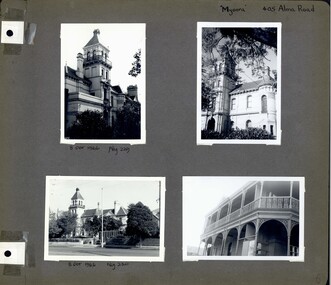
This photograph is part of the Caulfield Historical Album 1972. This album was created in approximately 1972 as part of a project by the Caulfield Historical Society to assist in identifying buildings worthy of preservation. The album is related to a Survey the Caulfield Historical Society developed in collaboration with the National Trust of Australia (Victoria) and Caulfield City Council to identify historic buildings within the City of Caulfield that warranted the protection of a National Trust Classification. Principal photographer thought to be Trevor Hart, member of Caulfield Historical Society. Most photographs were taken between 1966-1972 with a small number of photographs being older and from unknown sources. All photographs are black and white except where stated, with 386 photographs over 198 pages. Myoora - Victorian Heritage Register (VHR) Number H0490 https://vhd.heritagecouncil.vic.gov.au/places/275 Myoora, 405 Alma Road, North Caulfield, was designed by Reed, Henderson & Smart and can be attributed to Anketell Henderson. It was built in 1886 and 1887 for Thomas Christian, who had founded the fabled gold mine, the Day Dawn at Charters Towers. He never occupied the house although his widow lived there for some time. The house was subdivided into three and later six flats. Myoora was one of many large mansions on broad acres with gardens in Caulfield. Perhaps the grandest was Labassa. The mansions date from the 1850s through to the late 1890s. The siting of Myoora on a ridge influenced its planning and composition. A central hall and corridor along the ridge is entered from the centre of the more formal north facade. The entrance is marked by an elaborately detailed tower. A stair turret provides a second accent. The western end of the building is completed by a massively detailed chimney as the service wing. The south facade enjoyed an outlook to port phillip from a two-storey cast iron verandah. Bay windows, chimneys, the tower and the turret and minor details are brought together in a sophisticated asymmetrical composition. This is reflected in the planning. The asymmetry of Myoora pivoting on the tower is the most notable feature of the building. The walls are built of cement rendered brick. The cement render has not been painted. The roof is slate. The balconies and verandah are cast iron. The footings and cellar are bluestone. The architectural firm Reed, Henderson & Smart was very prominent in Victoria in the nineteenth century. Anketell Henderson was an eminent and well respected member of the profession. He worked successfully in London and interstate as well as in Victoria. They were better known for commercial and public buildings. Myoora is an important private commission. The style of Myoora is a combination of details from the Continental and English Renaissance through the boom style and the Queen Anne style. There is also an early influence from the American Romanesque style especially in the stair turret. The latter style was important at the turn of the century and Myoora is a significant precursor. Other buildings of a similar scale survive in Caulfield and elsewhere. Labassa, the most fabulous, is quite different stylistically as are most of the other comparable mansions.Page 6 of Photograph Album including four black and white photographs of the mansion Myoora. Two photographs in the top half of the page are in portrait orientation while the two photographs in the bottom half of the page are in landscape orientation.Handwritten: "Myoora" 405 Alma Rd [top right hand corner] / 8 Oct 1966 Neg 229 [underneath top left photograph] / 8 Oct 1966 Neg 230 [underneath bottom left photograph] / 6 [bottom right]caulfield north, trevor hart, alma road, mansion, myoora, tower, lacework, arched windows, anketell henderson, thomas christian, 1880's, cement rendered brick, slate roof, cast iron verandah, cast iron balconies, bluestone footings, queen anne, american romanesque, bay windows, boom style, continental and english renaissance, cast iron work, reed henderson & smart, flats, gardens, asymmetrical style -
 Glen Eira Historical Society
Album - Album page, Myoora, 405 Alma Road, Circa 1972
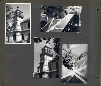
This photograph is part of the Caulfield Historical Album 1972. This album was created in approximately 1972 as part of a project by the Caulfield Historical Society to assist in identifying buildings worthy of preservation. The album is related to a Survey the Caulfield Historical Society developed in collaboration with the National Trust of Australia (Victoria) and Caulfield City Council to identify historic buildings within the City of Caulfield that warranted the protection of a National Trust Classification. Principal photographer thought to be Trevor Hart, member of Caulfield Historical Society. Most photographs were taken between 1966-1972 with a small number of photographs being older and from unknown sources. All photographs are black and white except where stated, with 386 photographs over 198 pages. Myoora - Victorian Heritage Register (VHR) Number H0490 https://vhd.heritagecouncil.vic.gov.au/places/275 Myoora, 405 Alma Road, North Caulfield, was designed by Reed, Henderson & Smart and can be attributed to Anketell Henderson. It was built in 1886 and 1887 for Thomas Christian, who had founded the fabled gold mine, the Day Dawn at Charters Towers. He never occupied the house although his widow lived there for some time. The house was subdivided into three and later six flats. Myoora was one of many large mansions on broad acres with gardens in Caulfield. Perhaps the grandest was Labassa. The mansions date from the 1850s through to the late 1890s. The siting of Myoora on a ridge influenced its planning and composition. A central hall and corridor along the ridge is entered from the centre of the more formal north facade. The entrance is marked by an elaborately detailed tower. A stair turret provides a second accent. The western end of the building is completed by a massively detailed chimney as the service wing. The south facade enjoyed an outlook to port phillip from a two-storey cast iron verandah. Bay windows, chimneys, the tower and the turret and minor details are brought together in a sophisticated asymmetrical composition. This is reflected in the planning. The asymmetry of Myoora pivoting on the tower is the most notable feature of the building. The walls are built of cement rendered brick. The cement render has not been painted. The roof is slate. The balconies and verandah are cast iron. The footings and cellar are bluestone. The architectural firm Reed, Henderson & Smart was very prominent in Victoria in the nineteenth century. Anketell Henderson was an eminent and well respected member of the profession. He worked successfully in London and interstate as well as in Victoria. They were better known for commercial and public buildings. Myoora is an important private commission. The style of Myoora is a combination of details from the Continental and English Renaissance through the boom style and the Queen Anne style. There is also an early influence from the American Romanesque style especially in the stair turret. The latter style was important at the turn of the century and Myoora is a significant precursor. Other buildings of a similar scale survive in Caulfield and elsewhere. Labassa, the most fabulous, is quite different stylistically as are most of the other comparable mansions.Page 7 of Photograph Album including four black and white photographs. Three photos are in a portrait orientation and placed diagonally across the page from the top left hand side to the bottom right hand side. One photograph in a landscape orientation is on the top right hand side of the page. Handwritten: 007 (bottom left hand corner)caulfield north, trevor hart, alma road, mansion, myoora, tower, thomas christian, 1880's, queen anne, cement rendered brick, unpainted, balconies, verandahs, anketell henderson, continental and english renaissance, american romanesque, views, cast iron work, reed henderson & smart, flats, gardens, asymmetrical style, slate roofs -
 Glen Eira Historical Society
Album - Album page, Caulfield State School, No 773, Glen Huntly Road, Circa 1972
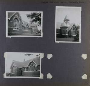
This photograph is part of the Caulfield Historical Album 1972. This album was created in approximately 1972 as part of a project by the Caulfield Historical Society to assist in identifying buildings worthy of preservation. The album is related to a Survey the Caulfield Historical Society developed in collaboration with the National Trust of Australia (Victoria) and Caulfield City Council to identify historic buildings within the City of Caulfield that warranted the protection of a National Trust Classification. Principal photographer thought to be Trevor Hart, member of Caulfield Historical Society. Most photographs were taken between 1966-1972 with a small number of photographs being older and from unknown sources. All photographs are black and white except where stated, with 386 photographs over 198 pages.From: Glen Eira Heritage Management Plan (1996) by Andrew Ward and Associates Caulfield State School No. 773 is important at the State level as the first of similar designs for small schools prepared by the Education Department under H.R. Bastow at Little Bendigo (1878), Glen Waverley (1880), Ascot (1882), Sandringham (1885) and Carlsrich (1892)·. It is a representative example of the Department's Gothic Revival designs, distinguished, however, by the semicircular treatment of the master's office, which compares with Portland (1879), Queensberry St Carlton (1880) and Footscray (1881). It has local significance as the earliest surviving Government School in Caulfield and as a centre for education from 1877, comparing with St. Mary's Jubilee School (qv) of 1887. The Caulfield State School of 1877, the horse tramway of 1889 and subsequently the electric trams were all events confirming the importance of Glenhuntly Road and the fledgling community of "Camden Town" wherein the City's commercial centre has its origins.Page 68 of Photograph Album with three exterior photographs (two portrait and one landscape) of one side of Caulfield State School with a fourth photo missing from the page.Hand written: Caulfield State School No. 773 Glenhuntly Road [top right] / 68 [bottom right] trevor hart, glen huntly road, caulfield state school, caulfield primary school, gothic revival, schools, caulfield south, arched window, tower, 1870's, camden town, red brick, curved windows, terracotta tiles, master's office, education, primary school, glenhuntly road, h r bastow -
 Glen Eira Historical Society
Album - Album page, London Tavern, Hawthorn Road, Circa 1972
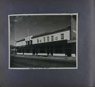
This photograph is part of the Caulfield Historical Album 1972. This album was created in approximately 1972 as part of a project by the Caulfield Historical Society to assist in identifying buildings worthy of preservation. The album is related to a Survey the Caulfield Historical Society developed in collaboration with the National Trust of Australia (Victoria) and Caulfield City Council to identify historic buildings within the City of Caulfield that warranted the protection of a National Trust Classification. Principal photographer thought to be Trevor Hart, member of Caulfield Historical Society. Most photographs were taken between 1966-1972 with a small number of photographs being older and from unknown sources. All photographs are black and white except where stated, with 386 photographs over 198 pages. Glen Eira Heritage Management Plan 1996 by Andrew Ward The 1857 rate book indicates that the major portion of the District was under pasture, although a considerable portion was cultivated. There were 159 houses, huts and tents whose occupants were mainly occupied on the land. If "Camden Town" was the principal commercial focus for the District in 1857, it was to remain so in later years, incorporated today in the Glenhuntly Road centre which extends more or less continuously from Elsternwick to Bambra Road. The Caulfield State School of 1877, the horse tramway of 1889 and subsequently the electric trams were all events confirming the importance of Glenhuntly Road and the fledgling community of "Camden Town" wherein the City's commercial centre has its origins. It is recalled, today, by their presence, and also by the "London Tavern" in Hawthorn Road, established by John Guess in 1873. Dr Geulah Solomon's 4 volume book "Caulfield's Heritage" Vol 1 p 93: "A modern hotel presently on the site continues the name of the London Tavern." That was true until recent years as the hotel is named The Camden Hotel now (2021).Page 81 of Photograph Album with one landscape photograph of the front of the London Tavern with handwriting on the edge of the photograph.Hand written: LONDON TAVERN HOTEL 1937 [on bottom edge of photo] / 81 [bottom left] trevor hart, caulfield, hawthorn road, london tavern, camden town, john guess, hotels, pubs, victorian, 1870's, 1930's, sycamore street, the camden hotel -
Glen Eira Historical Society
Article - Glen Huntly (House)
Photocopy of a short newspaper article from the Southern Cross, dated 18/06/1986, about Thomas Watt, who built Glen Huntly in 1855, one of the first substantial homes in the area. Refers briefly to the suburb’s residential and commercial development and includes a photograph (60mm x 145mm) of the exterior of Glen Huntly house and two photographs (37mm x 57mm) of the surrounding suburb. The file also includes a copy of a one page letter to the Historical Society of St Kilda from Nancy Renfree, dated 11/02/2000, about her great-grandfathers Thomas Watt and Henry Bunn, giving brief biographical information about both.glen huntly, glenhuntly, watts thomas, wilson john w, pioneers, huntly street, grange road, glenhuntly road, glen huntly road, architects, caulfield, station place, glenhuntly traders’ association, murray street, holy cross church, ricketson henry, glen eira, caulfield military hospital, caulfield, roads board, bunn henry, hotham street, ripponlea, weatherboard buildings, renfree nancy -
Glen Eira Historical Society
Document - Glenhuntly Road, Elsternwick
Three three page extracts from Andrew Ward’s 1994 Caulfield Conservation Study on commercial buildings in Glen Huntly Road, Elsternwick. The three studies concern Moore’s Buildings 1891 shops at 305-313 Glen Huntly Road, shops at 323-329 Glen Huntly Road and E J Buckeridge’s Buildings 1911 shops at 357-371 Glen Huntly Road. The studies describe the buildings’ architectural features, provide a historical overview and statements of the buildings’ significance, especially in relation to the Land Boom and commercial development between 1890 to the 19020s. All three studies include a black and white photograph (109mm x 152mm; 114mm x 150mm; 110mm x 151mm) of the shop fronts.glen huntly road, moore’s buildings 1891, italianate style, architectural styles, architectural features, verandahs, elsternwick, moore hugh, selwyn street, st georges road, glenmoore, glenmoore estate, corkill french and pugh, jamieson w w, thompson a g, eddy henrietta, valey frank, allen thomas, saddlers, dairy products, green w i, undertakers, delany edward, drapers, herbenstreit huldreich, butcher shops, sincock john, plumbers, allen t, greengrocers, coppel george, painters, dickinson f h, dickinson v, johnson thomas, cole constance, hairdressers, ortner frank, drycleaners, gaffney elodie, ward andrew, long mr, robinson mr, le page mr, byers robert, carter mary, millar c, smythe f c, crook thomas, stancy h, crook’s national stores pty ltd, e j buckeridge’s buildings 1911, kelly walter, staniland grove, buckeridge edward, hannon john, kellett frances, beck miss, armstrong miss, tuck mary, milliners, doherty john, adams herbert, bakeries, perry robert, picture framers, adams clifford, arches, windows, shops, land subdivision, retail trade, property developers, advertising signs -
Glen Eira Historical Society
Document - Beauville Estate
Promotional material for the Beauville Estate Murrumbeena 65th Heritage Celebration held 10/03/2001. This comprises, a leaflet about the launch of the Glen Eira Heritage Draft Guidelines with features of the Estate and addresses listed, a special invitation to the unveiling of the heritage plaque by Glen Eira Mayor Veronika Martens, and a Leader newspaper advertisement dated 12/02/2001 for the event, giving brief history of shops and resident anecdotes by Bev Baxter of Murrumbeena Pharmacy.beauville estate, murrumbeena, lindsay avenue 40-44 (even), 229-233 murrumbeena road, beaville avenue, gloucester court, dalny road 5-25 (north side only), 232-242 murrumbeena road (even), glen eira heritage draft guidelines, murrumbeena pharmacy, a v jennings, 227-235 murrumbeena road, barker ann, martens veronica, baxter bev, heritage festivals, plaques, quinn miss, webb rosemary, webb roy, cleave edna may, quirk john, quirk eva, ritchie, kirkbride thomas, beauville, glen eira port phillip pulse small business awards 2000, architectural features, brick houses, shops, residential development, tennis courts, housing estates, builders, building regulations, local government, commercial development, children’s playgrounds, advertisements, invitations, pharmacies, grocers, dentists, greengrocers, butchery shops, sweet shops -
Glen Eira Historical Society
Document - Beauville Estate
Beauville Estate Draft Heritage Guidelines, July 2000, produced by the Glen Eira City Council, author unknown, 25 pages. The Guidelines set out design parameters, principles and techniques for achieving appropriate heritage conservation objectives for the defined Beauville Estate Heritage Area, to be used by the Council, property owners, residents and designers. A number of photographs of houses and design features are included in the document as well as a brief history of the Estate and a Key Design Checklist.a v jennings construction co, gurney edward, jennings albert v sir, beauville estate, beauville estate heritage area, beauville avenue 1-39 (odd), beauville avenue 2-36 (even), dalny road 3-25 (odd), gloucester court 1-3 (odd), gloucester court 2-6 (even), lindsay avenue 40-44 (even), murrumbeena road 227-233 (odd), murrumbeena road 222-232 (even), murrumbeena, glen eira city council, architectural features, architectural styles, plans, brick houses, shops, residential development, tennis courts, housing estates, builders, building regulations, local government, commercial development, history, maps, photographs -
City of Kingston
Photograph - Black and white, 5 January 1984
Moorabbin, Cheltenham and Highett are suburbs in the City of Kingston with a diverse mix of development and zoning. The market gardens, farms and paddocks have gradually been sub-divided into housing and industrial estates and associated infrastructure such as schools and shopping facilities. The area includes many parks, reserves and golf courses.This aerial image covers a diverse section of the City of Kingston, taking in the suburbs of Cheltenham, Moorabbin, Beaumaris and Highett. By 1984, the market gardens of the district have been replaced by housing and factories. The Gas and Fuel state-of-the-art Scientific Services Department is visible on Nepean Highway Highett. The CSIRO Highett site can also be seen. Both sites have now been demolished and have undergone remediation. The Southland site is visible and yet to be redeveloped by Westfield. This image portrays the diversity of development in the City of Kingston with a mixture of green spaces, housing and commercial and industrial features.Aerial photograph of Cheltenham, Beaumaris, Moorabbin and Highett within the City of Kingston. The area depicted in the 1984 aerial view includes Eden Street and Edward Street, Cheltenham (top left), Weatherall Road and Reserve Road, Cheltenham/Beaumaris (top right), Turner Road and Chesterville Road, Moorabbin (bottom left), Nepean Highway (left section), Graham Road and Middleton Street, Highett (bottom right). A large section of this image includes Cheltenham Park and Victoria Golf Club.White text: 3831-219 Lens information [indecipherable] RINGWOOD M/S 7922-3 RUN 15 Clockface image 5,300' ASL VIC DLS© 5-1-84cheltenham, highett, industrialisation, urbanisation, moorabbin, beaumaris -
City of Kingston
Photograph - Black and white, 3 March 1954
Cheltenham and Moorabbin are suburbs within the City of Kingston that were originally established as rural market gardening communities The area is bordered by Highett and Mentone. The market gardens, farms and paddocks have gradually been sub-divided into housing and industrial estates. Highett is developed with residential homes but was also the site of major facilities such as the Highett Gas Works. This aerial image covers a diverse section of the City of Kingston, taking in the suburbs of Moorabbin, Cheltenham, Highett and Mentone Residential housing development is prominent along the Frankston Railway line and the area still retains extensive market gardens and paddocks yet to be converted to a large industrial and commercial zone.Aerial photograph of Mentone, Cheltenham and Moorabbin within the City of Kingston. The area depicted in this 1954 aerial view includes Warrigal Road and Centre Dandenong Road intersection (top left); Charman Road, Patty Street, Bourke Street, Collins Street Mentone (top right); Keys Road Moorabbin (bottom left); Bay Road, Cheltenham (bottom right), Friendship Square, Cheltenham Park, Victoria Golf Club and Jack Barker Oval are visible. Nepean Highway and the Frankston railway line run centrally through the image. Highett Gasworks is also evident.White handwriting and type [indecipherable]. White image of clockface White image of compass White type 42956 Black handwriting 3/3/54 Williams [indecipherable] Black pencil: S [arrow] Black ink: 3/3/1954cheltenham, moorabbin, mentone, highett, market gardens -
 Canterbury History Group
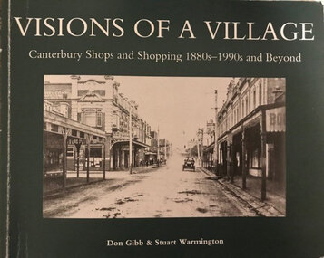
Book, Don Gibb et al, Visions of a Village : Canterbury shops and shopping 1880s-1990s and Beyond, 2016
Focussing on the growth and activities that took place in the shopping and service centre of Canterbury and Maling Roads in Canterbury from the 1880s to the present, it is partly a guide book to the present buildings of the centre through the streetscapes and brief lives of each of the premises.74 pages; black and white illustrations and photographs, including sketches of streetscapes. Includes bibliographical references and indexnon-fictionFocussing on the growth and activities that took place in the shopping and service centre of Canterbury and Maling Roads in Canterbury from the 1880s to the present, it is partly a guide book to the present buildings of the centre through the streetscapes and brief lives of each of the premises.canterbury road shopping centre, maling road, maling road> shops, shops, retail trade, commercial establishments, streetscapes -
 Melbourne Tram Museum
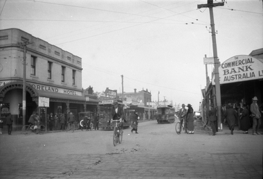
Negative, Ellis Collection, c1956
Negative (120) of the intersection of Moreland Road and Sydney Road, Brunswick, during the 1920's. In the view is a cable tram set shunting. A tramway employee and two boys at the front of the grip car seem to be manipulating something. Saloon car is No. 183 with the conductor pushing the car. The grip car has the destination of Brunswick and the saloon Flinders St? Note the two steel tramway poles and overhead for the North Coburg electric tram service from Moreland Rod into Sydney Road. In the background is the Moreland Hotel, Clarkson chemist and the Commercial Bank of Australia. An low resolution A4 laminated was received with the negatives. Hi Res image filed in the dbtext/hawthtramcoll/Large Images/htd3589large.jpgtrams, tramways, brunswick, cable trams, sydney rd, moreland rd, tram 183 -
 Melbourne Tram Museum
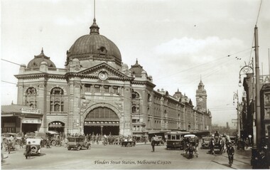
Photograph - Black and white - Flinders St Station c1920's
Shows H class tram number 57, east bound in Flinders St with the Flinders Street Railway station in the background. Has a number of horse drawn vehicles in the view along with motor cars and trucks, some of them doing a hook turn. A policeman is on point duty. Photo taken after Flinders St converted to electric trams from cable trams in 1927. Commercial print from a SLV photo.Yields information about the location, the streetscape and the trams and vehicles in use at the time. Original photo taken from a Rose Series - Southern Cross Series No. 5. See State Library of Victorian Collection - H2011.27DBlack and white photograph of Flinders St Station Melbourne, late 1920's with H class tram 57 in the view."RSCP 327" & "C1929" in pencil and "H57" in red ink on rear.tramways, h class, trams, tram 57, flinders st, flinders st station, horse drawn vehicles, mmtb -
 Melbourne Tram Museum
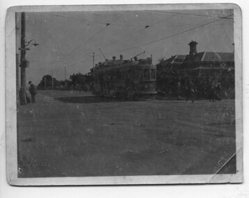
Photograph - HTT Tram 15 at Glenferrie and Riversdale Roads 1916-1920
Photograph shows Hawthorn Tramways Trust bogie Tram 15 at Glenferrie and Riversdale Roads 1916-1920. The tram body was built by Duncan and Fraser of Adelaide and entered service during April 1916. It was renumbered N class 121 by the Melbourne and Metropolitan Tramways Board following the absorption of the Trusts by the MMTB in 1920. The tram is eastbound in Riversdale Road. The tracks of the Prahran and Malvern Tramway Trust can be seen in front of the tram. The conductor has alighted from the tram and walked forward to check for trams on Glenferrie Road. A Fire Brigade street fire alarm can be seen on the corner. The existing connecting curves at the corner were installed in 1925. The tramcar had a number of significant accidents and was disposed of in March 1938. Understood from the donor, that the house on the corner was known as "Pax" and demolished when commercial development of the corner occurred. The donor's family operated the Purvis Real Estate on the southeast corner from the building now known as Stotts Corner. A Golden Fleece service station once operated from the SW corner, now (2022) an Oportunity shop.Yields information about the intersection of Riversdale and Glenferrie Roads Hawthorn, the trams that operated between 1916 and 1920 and tramway practices in having the conductor checking for trams on the adjacent road.Sepia toned or faded print of Hawthorn Tramways Trust tram No. 15 at the corner of Riversdale Road and Glenferrie Road, Hawthorn - first image is a greyscale scan of original image.trams, tramways, hawthorn, riversdale road, glenferrie road, hawthorn tramways trust, tram 15, htt, stotts corner, purvis real estate -
 Melbourne Tram Museum
Photograph - Black and White - Flinders St looking east - 1915c
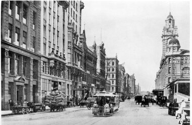
Photo of Flinders St looking east from about Queen Street, c1915. Has many horse drawn vehicles and one cable tram with two ladies riding on the front of the grip car. In the view are Robert Reid & Co, Commerce House, Finks building and Flinders St Station. The station was completed in 1909. Commerce House or the Commercial Travellers Association building was completed in 1913 - see reference.Yields information about Flinders Street between Queen and Elizabeth Streets.Photograph - Black and White - Flinders St looking east - 1915c from near Queen Street.tramways, trams, cable cars, flinders street, commerce house, cta building, flinders street station -
 Melbourne Tram Museum
Photograph - Enlargement of a postcard, Bridge Road Richmond, c1900
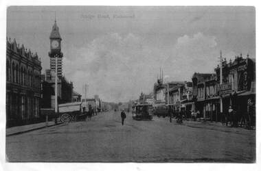
The first image shows the shops on either side of Bridge Road with horse drawn carts and one cable tram. The second image from the Town Hall tower, shows two cable tram sets, the narrowing of the road. Has in the view Guddon & Selleck Auction House and Property Exchange also advertising Commercial Union Assurance Co. and George Stirling and Sons store.Yields information about Bridge Road, c1900Set of two A3 enlargements of postcards 1 - Looking east along Bridge Road from near Church St 2 - Bridge Road Richmond - from Town Hall looking westcable trams, tramways, richmond, bridge road, -
 Melbourne Tram Museum
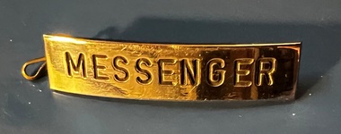
Badge - "Messenger"
Item to indicate that the person was an authorised Messenger. Possibly a commercially available item. Not know whether the MMTB or The Met used this item though it was donated by a person who worked for both organisations.Demonstrates a method of indicating that the person was acting as a Messenger.Badge - nickel plated or silver finish, rounded with two lugs on rear for clipping onto a cap or a uniform - has the word "Messenger" stamped or engraved. Two copies held, one with a single brass clip.public transport, transport, badges, messenger, uniform -
 Melbourne Tram Museum
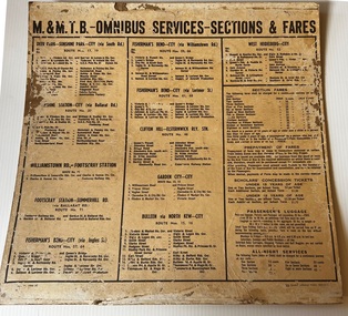
Poster, Melbourne & Metropolitan Tramways Board (MMTB), "M&MTB - Omnibus Services - Sections & Fares", 1966
Provides details of fares for each section, and location of sections for all bus routes. Notes prepayment of fares, children fares, and passengers' luggage including All-night services. Dated 1966, following the introduction of decimal currency. Yields information about bus routes, sections and fares in 1966.Poster, paper mounted or glued to cardboard sheet for use in buses - titled "M&MTB - Omnibus Services - Sections & Fares"public transport, buses, fares, mmtb, posters, routes