Showing 15996 items matching "b "
-
 Ringwood and District Historical Society
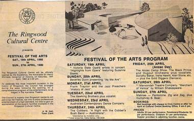
Newspaper - Clipping, Festival of the Arts Program, Ringwood Cultural Centre, Karralika Theatre, Mines Rd., Ringwood, Saturday 19th April to Sunday 27th April 1980
Ringwood Mail clipping of 26/03/1980, advising the timetable and description of events Program listed events such as Opera, Jazz, Country music, Contemporary Dance, Bush Band, Orchestra with vocals, Shakespeare (Merchant of Venice) and Sunday matinee which featured pantomime, Zig and Zag and Humphrey B. Bear. The Festival was officially opened by Sir Henry Winneke on Saturday, 19th April, 1980 at 2.30 pm. -
 City of Kingston
Pamphlet - Colour, Smith, Nicolson Pty. Ltd, Cheltenham Estate, c. 1890
Sales plan for land in the suburb of Cheltenham, bounded by Point Nepean Road and Swinden Avenue, including Evesham Road and Wallingford Street.The developing urban area of Cheltenham within the City of Kingston. This land sale pamphlet illustrates the subdivision of land within the municipality and the changing demographic of the district as new houses are constructed close to infrastructure.Colour pamphlet advertising for private sale Cheltenham Estate. Incorporates a map of the estate bordered by Point Nepean Road and Swinden Avenue, including Evesham Road, and Wallingford Street.Handwritten in red ink on subdivison 45: D / H Handwritten in red ink on subdivision 46: Anderson Handwritten in red ink on subdivisions 88, 87, 77 and 56: K / D Handwritten in red ink on subdivision 86: D / H Handwritten in red ink on subdivision 63 and 62: Hudson Handwritten in red ink on subdivision 59 [indecipherable] Handwritten in red ink on subdivision 58: aB Handwritten in red ink on subdivision 57: Lavosh Handwritten in grey pencil on subdivision 28, 26, 24, 67, 58, 49: B Handwritten in grey pencil on subdivisions 78 and 79: Paint Handwritten in purple pencil on subdivsion 114 and 86: B land sales, estate, cheltenham -
 Flagstaff Hill Maritime Museum and Village
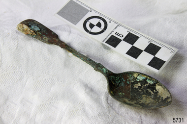
Domestic object - Spoon, circa 1878
This tea spoon is from the wreck of the LOCH ARD, a Loch Line ship of 1,693 tons which sailed from Gravesend, London, on 2 March 1878 with 17 passengers and a crew of 36 under Captain George Gibbs. “The intention was to discharge cargo in Melbourne, before returning to London via the Horn with wool and wheat”. Instead, on 1 June 1878, after 90 days at sea, she struck the sandstone cliffs of Mutton Bird Island on the south west coast of Victoria, and sank with the loss of 52 lives and all her cargo. The manifest of the LOCH ARD listed an array of manufactured goods and bulk metals being exported to the Colony of Victoria, with a declared value of £53,700. (202 bills of lading show an actual invoice value of £68, 456, with insurance underwriting to £30,000 of all cargo). Included in the manifest is the item of “Tin hardware & cutlery £7,530”. This teaspoon is one of 482 similar items of electro-plated cutlery from the LOCH ARD site, comprising spoons and forks of various sizes but all sharing the same general shape or design and metallic composition. 49 of these pieces display a legible makers’ mark — the initials “W” and “P” placed within a raised diamond outline, which is in turn contained within a sunken crown shape — identifying the manufacturer as William Page & Co of Birmingham. An electroplater’s makers’ marks, unlike sterling silver hallmarks, are not consistent identifiers of quality or date and place of manufacture. A similar line of five impressions was usually made to impress the consumer with an implication of industry standards, but what each one actually signified was not regulated and so they varied according to the whim of the individual foundry. In this case, the maker’s marks are often obscured by sedimentary accretion or removed by corrosion after a century of submersion in the ocean. However sufficient detail has survived to indicate that these samples of electro-plated cutlery probably originated from the same consignment in the LOCH ARD’s cargo. The following descriptions of maker’s marks are drawn from 255 tea spoons, 125 dessert spoons, and 99 table forks. These marks are clearly visible in 66 instances, while the same sequence of general outlines, or depression shapes, is discernible in another 166 examples. 1. A recessed Crown containing a raised Diamond outline and the initials “W” and “P” (the recognised trademark of William Page & Co) 2. An impressed Ellipse containing a raised, pivoted, Triangle in its lower part and bearing a Resurrection Cross on its upper section (a possible dissenting church symbol reflecting religious affiliation); OR a rounded Square impression containing a raised, ‘lazy’, letter “B” (possibly mimicking sterling silver hallmark signifying city of manufacture i.e. Birmingham) 3. An impressed rounded Square filled with a raised Maltese Cross (the base metal composite of nickel silver was also known as ‘German silver’ after its Berlin inventors in 1823) 4. A recessed Circle containing a Crab or Scarab Beetle image; OR a recessed Circle containing a rotated ‘fleur de lys’ or ‘fasces’ design 5. A depressed Diamond shape enclosing a large raised letter “R” and a small raised letter “D” (mimicking the U.K. Patent Office stamp which abbreviated the term ‘registered’ to “RD”, but also included date and class of patent) Suggested trade names for William Page & Co’s particular blend of brass plating are ‘roman silver’ or ‘silverite’. This copper alloy polishes to a lustrous gold when new, discolouring to a murky grey with greenish hue when neglected. HISTORY OF THE LOCH ARD The LOCH ARD belonged to the famous Loch Line which sailed many ships from England to Australia. Built in Glasgow by Barclay, Curdle and Co. in 1873, the LOCH ARD was a three-masted square rigged iron sailing ship. The ship measured 262ft 7" (79.87m) in length, 38ft (11.58m) in width, 23ft (7m) in depth and had a gross tonnage of 1693 tons. The LOCH ARD's main mast measured a massive 150ft (45.7m) in height. LOCH ARD made three trips to Australia and one trip to Calcutta before its final voyage. LOCH ARD left England on March 2, 1878, under the command of Captain Gibbs, a newly married, 29 year old. She was bound for Melbourne with a crew of 37, plus 17 passengers and a load of cargo. The general cargo reflected the affluence of Melbourne at the time. On board were straw hats, umbrella, perfumes, clay pipes, pianos, clocks, confectionary, linen and candles, as well as a heavier load of railway irons, cement, lead and copper. There were items included that intended for display in the Melbourne International Exhibition in 1880. The voyage to Port Phillip was long but uneventful. At 3am on June 1, 1878, Captain Gibbs was expecting to see land and the passengers were becoming excited as they prepared to view their new homeland in the early morning. But LOCH ARD was running into a fog which greatly reduced visibility. Captain Gibbs was becoming anxious as there was no sign of land or the Cape Otway lighthouse. At 4am the fog lifted. A man aloft announced that he could see breakers. The sheer cliffs of Victoria's west coast came into view, and Captain Gibbs realised that the ship was much closer to them than expected. He ordered as much sail to be set as time would permit and then attempted to steer the vessel out to sea. On coming head on into the wind, the ship lost momentum, the sails fell limp and LOCH ARD's bow swung back. Gibbs then ordered the anchors to be released in an attempt to hold its position. The anchors sank some 50 fathoms - but did not hold. By this time LOCH ARD was among the breakers and the tall cliffs of Mutton Bird Island rose behind the ship. Just half a mile from the coast, the ship's bow was suddenly pulled around by the anchor. The captain tried to tack out to sea, but the ship struck a reef at the base of Mutton Bird Island, near Port Campbell. Waves broke over the ship and the top deck was loosened from the hull. The masts and rigging came crashing down knocking passengers and crew overboard. When a lifeboat was finally launched, it crashed into the side of LOCH ARD and capsized. Tom Pearce, who had launched the boat, managed to cling to its overturned hull and shelter beneath it. He drifted out to sea and then on the flood tide came into what is now known as LOCH ARD Gorge. He swam to shore, bruised and dazed, and found a cave in which to shelter. Some of the crew stayed below deck to shelter from the falling rigging but drowned when the ship slipped off the reef into deeper water. Eva Carmichael had raced onto deck to find out what was happening only to be confronted by towering cliffs looming above the stricken ship. In all the chaos, Captain Gibbs grabbed Eva and said, "If you are saved Eva, let my dear wife know that I died like a sailor". That was the last Eva Carmichael saw of the captain. She was swept off the ship by a huge wave. Eva saw Tom Pearce on a small rocky beach and yelled to attract his attention. He dived in and swam to the exhausted woman and dragged her to shore. He took her to the cave and broke open case of brandy which had washed up on the beach. He opened a bottle to revive the unconscious woman. A few hours later Tom scaled a cliff in search of help. He followed hoof prints and came by chance upon two men from nearby Glenample Station three and a half miles away. In a state of exhaustion, he told the men of the tragedy. Tom returned to the gorge while the two men rode back to the station to get help. By the time they reached LOCH ARD Gorge, it was cold and dark. The two shipwreck survivors were taken to Glenample Station to recover. Eva stayed at the station for six weeks before returning to Ireland, this time by steamship. In Melbourne, Tom Pearce received a hero's welcome. He was presented with the first gold medal of the Royal Humane Society of Victoria and a £1000 cheque from the Victorian Government. Concerts were performed to honour the young man's bravery and to raise money for those who lost family in the LOCH ARD disaster. Of the 54 crew members and passengers on board, only two survived: the apprentice, Tom Pearce and the young woman passenger, Eva Carmichael, who lost all of her family in the tragedy. Ten days after the LOCH ARD tragedy, salvage rights to the wreck were sold at auction for £2,120. Cargo valued at £3,000 was salvaged and placed on the beach, but most washed back into the sea when another storm developed. The wreck of LOCH ARD still lies at the base of Mutton Bird Island. Much of the cargo has now been salvaged and some was washed up into what is now known as LOCH ARD Gorge. Cargo and artefacts have also been illegally salvaged over many years before protective legislation was introduced. One of the most unlikely pieces of cargo to have survived the shipwreck was a Minton porcelain peacock - one of only seven in the world. The peacock was destined for the Melbourne International Exhibition in 1880. It had been well packed, which gave it adequate protection during the violent storm. Today, the Minton peacock can be seen at the Flagstaff Hill Maritime Museum in Warrnambool. From Australia's most dramatic shipwreck it has now become Australia's most valuable shipwreck artefact and is one of very few 'objects' on the Victorian State Heritage Register. The LOCH ARD shipwreck is of State significance – Victorian Heritage Register S 417. Flagstaff Hill’s collection of artefacts from LOCH ARD is significant for being one of the largest collections of artefacts from this shipwreck in Victoria. It is significant for its association with the shipwreck, which is on the Victorian Heritage Register (VHR S417). The collection is significant because of the relationship between the objects, as together they have a high potential to interpret the story of the LOCH ARD. The LOCH ARD collection is archaeologically significant as the remains of a large international passenger and cargo ship. The LOCH ARD collection is historically significant for representing aspects of Victoria’s shipping history and its potential to interpret sub-theme 1.5 of Victoria’s Framework of Historical Themes (living with natural processes). The collection is also historically significant for its association with the LOCH ARD, which was one of the worst and best known shipwrecks in Victoria’s history. Unrestored tea spoon from the wreck of the LOCH ARD. The spoon design has a flattened fiddle-back handle, with a thin stem or shank, flared collar, and elongated bowl. The spoons metallic composition is a thin layer of brass alloy which has partially corroded back to a nickel-silver base metal. Approximately 15% of original electroplating survives with some verdigris. 15% of surface has encrustation, on handle and also on back of bowl. Three of five makers marks are partially distinguishable on lower rear of handle: (2) Lazy "B" (3) Maltese Cross (4) Fleur de Lys.flagstaff hill, warrnambool, shipwrecked coast, flagstaff hill maritime museum, maritime museum, shipwreck coast, flagstaff hill maritime village, great ocean road, loch line, loch ard, captain gibbs, eva carmichael, tom pearce, glenample station, mutton bird island, loch ard gorge, electroplated cutlery, loch ard shipwreck, nickel silver, william page & co, birmingham, brass plating, makers marks -
 Bendigo Military Museum
Administrative record - Advisory Committee on Commonwealth Mapping Meeting Notes - (National Mapping Council Meetings), Circa 1972
Advisory Committee on Commonwealth Mapping (ACOCM) Meeting Notes. 15 Items of typed pages and diagrams. .1 Letter to the Hon WS Kent Hughes MVO, OBE, Mc, ED, MP, Minister for the Interior, ACT Signed Jos Francis. Cabinet Decision taken on 22 July 1954, effects on current military mapping agreements between AUS, UK and USA. Australian responsibility "Noted was the fact that RASvy was in preparation for War." .2 Letter by H Wells Lieutenant General, Chief of the General Staff, 17 Feb 1955. Refers to the invitation of Major General RL Brown UK Defence to visit Australia to help align the mapping programme. .3 Draft Cabinet Submission on National Mapping Survey and Mapping Co-ordination of the 22 July 1955. Attachment 1 Cabinet Minute, Vice-President's letter Canberra22 July 1954. Decision No2 (VP). Submission 8 National Mapping Survey and Mapping Co-ordination. .4 Air photography and Mapping Programme 1956/57. Signed by LF Fitzgerald OBE Director of Military Survey 26 Jan 56. .5 Letter Hon WS Kent Hughes MVO, OBE, MC, ED, MP. Minister for the Interior ACT. Confirming the Cabinet Decision No2 (VP) Signed by Joe Francis .6 National Mapping Programme 1956/57. States a view to Army's contribution to this programme .7 Clarifies Army participation in Cabinet Decision No2 (VP) .8 History of National Mapping Asst Secretary (General) 24 Apr 1958 .9 Report on Army Committee on National Mapping. 2 July 1958 .10 RASvy Brief Review of Activities Jan - Dec 1964 .11 Advisory Committee on Commonwealth Mapping Meeting Notes 12 Feb 1965 - Agenda item 8. This endorsed the principle of grouping Commonwealth Mapping Agencies in a Survey Mapping Group in Canberra which included AHQ Survey Regiment. This did not come to fruition. .12 Advisory Committee on Commonwealth Mapping Meeting Notes 12 Feb 1965 - Agenda item 8 para 5.1.3 - 11.2 .13 ACOCM Meeting Agenda 1968 .14 ACOCM Meeting Minutes 1970 .15 Letter to Mr B White CBE Secretary from LF BottAdvisory Committee on Commonwealth Mapping (ACOCM) Meeting Notes. 15 Items of typed pages and diagrams. .1 Letter 22 July 1954 .2 Letter 17 Feb 1955 .3 Letter 22 July 1955 .4 letter 26 Jan 1956 .5 Letter Hon WS Kent Hughes Minister for the Interior ACT .6 National Mapping Programme 1956/57 .7 Clarifies Army participation in Cabinet Decision No2 (VP) .8 History of National Mapping 24 Apr 1958 .9 Report on Army Committee on National Mapping 2 July 1958 .10 RASvy Brief Review of Activities Jan - Dec 1964 .11 Advisory Committee Meeting Notes 12 Feb 1965 - Agenda item 8 .12 Advisory Committee Meeting Notes 12 Feb 1965 - Agenda item 8 para 5.1.3 - 11.2 .13 ACOCM Meeting Agenda 1968 .14 ACOCM Meeting Minutes 1970 .15 Letter to Mr B White CBE Secretary from LF Bottroyal australian survey corps, rasvy, fortuna, army survey regiment, army svy regt, asr, national mapping -
 Wycheproof & District Historical Society Inc.
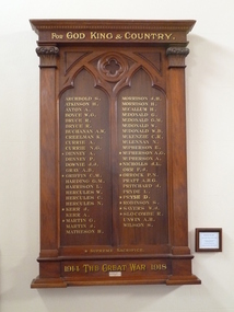
Wycheproof Honour Roll, FOR GOD KING AND COUNTRY 1914 -1918 WAR, 1919
This Honour Board listing of servicemen contributes to and is part of a National collection of Memorials to honour our armed forces. Listed are 49 names of whom 11 are Fallen.This Presbyterian Church Honour Board is believed to be the only existing 1914 - 1918 Board of its type. It has social and cultural value - and is of local,State and National importance.Large rectangular solid varnished wooden Memorial has inscribed, in gold lettering, 49 local Wycheproof and District servicemen, 11 of whom are marked Fallen. Below the top edging is some ornate wooden decoration. ARCHBOLD S . / ATKINSON H. / AXTON A. / BOYCE W.G. / BRUCE R. / BRYCE R. / BUCHANAN A.W. / CREELMAN K. / CURRIE A./ CURRIE N.G. / + DENNEY A. / DENNEY P./ DOWNIE J.J. / GRAY A.B. / + GRIFFIN C. M. / HARDING G.M. / HARRISON L . / HERCULES W. / HERCULES C. / HERCULES N. / + KERR J. / KERR A. / MARTIN G. / MARTIN J. / MATHESON H. / MORRISON J.H. / MORRISON H. / McCALLUM H. / McDONALD G. / McDONALD G. / McDONALD G.M. / McDONALDW. / McDONALD W. B. / McKENZIE C.R. / McLENNAN C.R. / McPHERSON E. / + McPHERSON A.G. / McPHERSON A. / + NICHOLLS J.L. / ORR F.J. / +ORROCK P.N. / PRATT A.H.G. / PRITCHARD J. / PRYDE L. / + PRYSE D. / + ROBINSON S. / + SAYERS W.J. + SLOCOMBE R. / UNWIN A.H. / WILSON S. Silver plaque attached reads: Presented by Mrs M.J. Matheson 1919 ARCHBOLD S . / ATKINSON H. / AXTON A. / BOYCE W.G. / BRUCE R. / BRYCE R. / BUCHANAN A.W. / CREELMAN K. / CURRIE A./ CURRIE N.G. / + DENNEY A. / DENNEY P./ DOWNIE J.J. / GRAY A.B. / + GRIFFIN C. M. / HARDING G.M. / HARRISON L . / HERCULES W. / HERCULES C. / HERCULES N. / + KERR J. / KERR A. / MARTIN G. / MARTIN J. / MATHESON H. / MORRISON J.H. / MORRISON H. / McCALLUM H. / McDONALD G. / McDONALD G. / McDONALD G.M. / McDONALDW. / McDONALD W. B. / McKENZIE C.R. / McLENNAN C.R. / McPHERSON E. / + McPHERSON A.G. / McPHERSON A. / + NICHOLLS J.L. / ORR F.J. / +ORROCK P.N. / PRATT A.H.G. / PRITCHARD J. / PRYDE L. / + PRYSE D. / + ROBINSON S. / + SAYERS W.J. + SLOCOMBE R. / UNWIN A.H. / WILSON S. Silver plaque attached reads: Presented by Mrs M.J. Matheson 1919 wycheproof presbyterian - church, first world-war, honour roll, matheson, m.j -
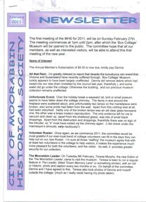 City of Moorabbin Historical Society (Operating the Box Cottage Museum)
Newsletter, City of Moorabbin Historical Society Feb 2011, February 2011
The City of Moorabbin Historical Society was formed c 1960 by a group of Moorabbin residents who were concerned that the history of the area should be preserved. A good response to a call for items related to the historical area of Moorabbin Shire brought donations of a wide variety of artefacts which are now preserved by the current members of CMHS at Box Cottage Museum . Helen Stanley, Secretary of CMHS, began producing a Newsletter for members in April 2007 to provide current information and well researched items of historical interestHelen Stanley has produced a bi-monthly Newsletter, 2007 - 2013, for the members of the City of Moorabbin Historical Society that contains well researched interesting historical items, notification of upcoming events, current advice from Royal Australian Historical Society , Museums Australia Victoria and activities of Local Historical Societies. The Newsletter is an important record of the activities of the CMHS and this month Celebrates the 50th Anniversary of CMHS. The puzzle around the naming of the suburb McKinnon tells the story of Daniel, Donald and Laughlin MacKinnon. 5 x A4 paper printed on 1 side Issue 20 of the bi-monthly, City of Moorabbin Historical Society Newsletter produced by Society member and Secretary, Mrs Helen Stanley in February 2011. Notice for meeting February 27th and the Subscription $5 is due. Despite the recent heavy rain the Cottage and grounds were unaffected, however an possum / rat appears to have entered the Cottage via the Chimney and caused the breakage of 2 glass kerosene lamps that were on the mantelpiece and lots of droppings before escaping. Teresa Murphy, editor of ‘The Moorabbin Leader’ Newspaper, visited Box Cottage and discussed a proposed regular feature ‘Down Memory Lane’. Volunteers are requested for Open Days, and are reminded of the Visitors’ Book, Children’s Treasure Hunt Cards and the Volunteer Hours Record. Accompanying it is the Story of Daniel MacKinnon b Glasgow arrived Port Phillip 1839 died 1889, his son Donald MacKinnon b 1859 Terang, Victoria – 1932 and Laughlan MacKinnon b1817 Isle of Skye -1888 no relation to eitherCITY of MOORABBIN HISTORICAL SOCIETY / FEBRUARY 2011 NEWSLETTER city of moorabbin historical society, stanley helen, mackinnon daniel, mackinnon donald, mackinnon laughlin, melbourne, moorabbin, brighton, cheltenham, ormond, bentleigh, mckinnon, market gardeners, pioneers, early settlers, moorabbin shire, box cottage museum, city of moorabbin, box william, glen eira historical society, the moorabbin leader newspaper, murphy teresa, the argus newspaper -
 Bendigo Historical Society Inc.
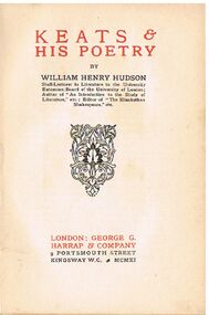
Book - ALEC H CHISHOLM COLLECTION: BOOK ''KEATS & HIS POETRY'' BY WILLIAM HENRY HUDSON
Book. ALEC H CHISHOLM COLLECTION. 95 page soft cover booklet by William Henry Hudson on the life and poetry of John Keats. Contains a selection of poems, some in part only, with an accompanying discussion on each. B & W image of John Keats opposite title page. Published in 1911 by George G. Harrap & Co., London and printed by Ballantyne & Co., London. Catalogue sticker ''2260 HUD'' on spine. Signature ''A. H. Chisholm'' inside front cover. Seven newspaper articles relating to Keats, loose inside front cover. (a) Argus 4-5-40 Poet who died young. (b) Sydney Morning Herald 9-4-67 Keats seen again as Shakespeare's heir. (c Age 26-7-58 Keats's Ode to a Nightingale. (d) Age 3-11-63 Keats's Ode to a Nightingale (e) Age 4-5-63 Keats's Legend of St Agnes. (f) Age 17-5-58 Keats's Ode to a Grecian Urn. (g) Unknown paper and date Two new sonnets (by Keats).William Henry Hudsonbooks, collections, poetry, alec h chisholm collection, john keats, poetry, william henry hudson -
 Bendigo Historical Society Inc.
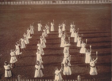
Photograph - CLUB SWINGERS 1903, GROUP OF GIRL GYMNASTS, 1903
Black and white photograph of thirty one girl gymnasts wearing short white frocks, with sashes and holding wooden clubs. Top of picket fence visible at bottom of image. Low picket fence at back with higher metal? Fence behind it. Mounted on grey board Inscriptions: on back - 'Club Swingers 1903', Winners of Austral Competition, Bendigo. 'Miss Stean's pupils', 'photo No.5' (written on white card, taped to back). ' I Harry, 46 Clyde St., East Kew'. Names from top to bottom? M Kerr, Annie Steane, Olwen Parry, B Robertson, E Saunders, L Bolten, L Lee, J Charles, R Wilson, L Wilson, , E Manning, J Steane, E Herschell, M Sapping / Lapping?, E Charles, I Harry, C Manning, E Stevenson, A Hues, L Mitchell, M Simmons, E Stewart, A Curneson / Curnecon?, R Hanson, D Manning, J McCraw, R Judd, B Whitelock, C Tyek, D Unmack.person, group, sports team -
 Bendigo Historical Society Inc.
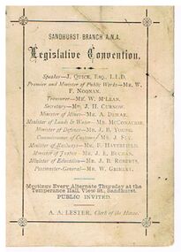
Document - DOCUMENT - SANDHURST BRANCH A. N. A. LEGISLATIVE CONVENTION
Small, white card, Sandhurst Branch A. N. A. Legislative Convention. Possibly 1889, see newspaper article 22nd August, 1889, Bendigo Advertiser. Named are the Speaker - J. Quick, Esq., L. L. D., Premier and Minister of Public Works - Mr. W. F. Noonan, Treasurer - Mr. W. McLean, Secretary - Mr. J. H. Curnow, Minister of Mines - Mr. A. Dewar, Minister of Lands & Water - Mr. McConachie, Minister of Defence - Mr. J. B. Young, Commissioner of Customs - Mr. J. Fry, Minister of Railways - Mr. F. Haverfield, Minister of Justice - Mr. J. E. Buchan, Minister of Education - Mr. J. B. Roberts, Postmaster-General - Mr. W. Grimley. A. A. Lester, Clerk of the House. ' Meetings every alternate Thursday at the Temperance Hall, View Street, Sandhurst.' Printing surrounded by border with a flower where the corners intersect. On the back is a drawing with a vase of flowers sitting on a raised part which is wider at the bottom. It has a plant engraving and underneath are two doves and a feather pattern fan.bendigo, clubs, ana, document, sandhurst branch a. n. a., j quick, w f noonan, w mclean, j h curnow, a dewar, mr mcconachie, j b young, j fry, f haverfield, j e buchan, j b roberts, w grimley, a a lester -
 Bendigo Historical Society Inc.
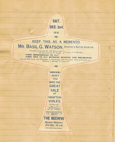
Book - BASIL WATSON COLLECTION: EXERCISE BOOKS (NEWSPAPER CUTTING, 1916=-1918
Collection of six Exercise Books (newspaper cuttings re B Watson and WWI aviation), compiled by Robert Keith Munro 126 Forest St, Bendigo. A. (Book #1) : ''Newspaper cuttings'' - first half of book is largely returned/killed soldiers, some cuttings on Basil Watson; second half - Basil Watson related cuttings; b. (Book #2): ''Newspaper cuttings in connection with Basil G Watson's Western District flights'' (1917); c. (Book #3): ''News Cuttings in connection with Basil G Watson, Aviator and Aeroplane'' (1917); d. (Book 4): ''Sundry Newspaper Cuttings re the late Mr Basil G Watson'' (1917; 1918 and Sun News Pictorial 28/3/1942); e. (Book #5): ''Miscellaneous News Cuttings'': mostly other airmen and post-BW cuttings (includes A4 sized poster for BW to appear at 'The Great Carnival' at Caulfield Racecourse March 29-31, 1917; f, (Book 6): containing various posters, tickets and souvenirs relating to BW. -
 Ballarat Tramway Museum
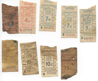
Ephemera - Ticket/s, State Electricity Commission of Victoria (SECV), Set of 9 mixed SEC tickets found in Ballarat No. 28, mid 1960's to late 1960's
Set of 9 mixed SEC tickets found in Ballarat No. 28, behind the north side sandboxes No. 2 end 6/1/1999. Tickets have been used and have varying degrees of dirt. The image file shows the nature of the damage. Tickets have not been individually numbered with the Registration Number, but can be identified by their ticket number and denomination. All SEC decimal tickets with one SEC pre decimal issue. All on white paper unless otherwise noted. 3d - 45 004131, black ticket with 3d in blue on pink paper, plain back 4c - B 177166 - red ticket, SEC logo on back 5c - B 271063 - yellow ticket, SEC logo on back 7c - B251545, turquoise ticket, SEC logo on back 7c - B385254 - turquoise ticket, SEC logo on back 7c - B447403 - turquoise ticket, SEC logo on back 10c - B873852 - black ticket, SEC logo on back 10c - B995920 - black ticket, SEC logo on back 15c - A202245? - brown ticket, tartan back trams, tramways, tickets, used tickets, secv, ballarat -
 Melbourne Tram Museum
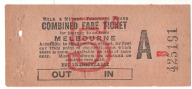
Ephemera - Ticket/s, Melbourne & Metropolitan Tramways Board (MMTB), "Combined Fare Ticket" - MMTB, early 1930's?
Ticket - light brown paper, "Combined Fare Ticket" - MMTB, over printed with a red 5d, and Ticket Number A B 425191. with conditions of travel on the front. On the rear is printed in red ink is an advert for B. Matthews Pty Ltd, with head office at 102-110 Toorak Road, South Yarra, advertising a Motor Funeral Service. Dean Filgate advised 24-12-2020: Unfortunately an un-used example, from the same block that most collectors obtained one for their collection ! There are genuine used examples of similar 6d (purple overprint) tickets, however I cannot find my "files" about these: there were at least two places this type of ticket was used in the early to mid-1930s. One was a "Combined Fare Ticket to and from the City via The Coburg Electric and Brunswick Cable Cars", the other was used on the Glen Huntly lines to enable passengers to pay only once for their journey to the City, as until 1934 trams from Glen Huntly Depot did not run direct to the City - you had to transfer trams at Elsternwick or Ripponlea.trams, tramways, melbourne, tickets, mmtb, advertisements -
 Kiewa Valley Historical Society
Photograph - Folder of Photographs – Photocopied set of black and white photographs (pages 49 -58) from the display folder put together by KVHS to document life on the Kiewa Valley Hydro-electric Scheme
Although the Kiewa Hydro-Electric Scheme was first proposed in 1911, construction did not commence until 1938. As part of the push to cut electricity costs and diversify supply, the Victorian Government (circa 1930) initiated the conversion from primarily brown coal supply to hydro – electricity. Field investigations during the 1940’s resulted in a new proposal for a scheme that had more than double the capacity of the 1938 scheme. The Kiewa Hydroelectric Scheme became the largest scheme of its kind in the State Of Victoria and the second largest scheme in Australia. The number of personnel involved in the planning and construction of the scheme increased dramatically. During the late 1940’s, most activity centred around the construction of the West Kiewa Power Station, Rocky Valley Reservoir, McKay Creek Power Station and the Bogong Creek Aqueduct.A common thread across all the larger hydro scheme constructions was the need for workers, both qualified and unqualified who came from around the world seeking a new life for themselves and their families. New accommodation and facilities were required for the army of workers engaged in construction in often remote and wild areas. The SEC had a high demand for timber, and set up the first of a number of sawmills at Bogong Creek in 1939 and set up the first hardwood logging in the headwaters of the Kiewa River. These new ‘towns’ such as Mt Beauty and Bogong, survived, serving the needs of operational personnel and their families, and expanding with growth of new industries. Mount Beauty, and to a lesser extent Bogong, are among these places. Large A3 size spiral bound display folder containing photocopied black and white photographs of various aspects of the early days of the Kiewa Valley Hydro-electric scheme including equipment, various work sites and photographs of workers and their families. 1-Workmen working inside one of the tunnels. 2-Workman drilling in West Kiewa Tunnel 3-Junction Dam wall construction 4&5-2B&W photographs Kiewa House residents ready to go to a ball in Mt Beauty 6-Workmen warming up in front of a fire at No 1 bench 7-Workmen being hauled in at No 4 P.S Shaft 8-No 4 Power Station – Drilling 9-Workmen eating a hot meal in the tunnel. 10-2 photographs (a)Pretty Valley camp showing workman’s huts and construction materials & (b)Worker in Langford Gap Basalt Hill Tunnel face 11-Tunnel entrance (unlabelled) with rail tracks in foreground 12- Workmen drilling at No 1 Head race tunnel-Drilling face 13- No 1 Power Station 14-Workmen at the entrance to one of the SECV tunnels under construction 1-SECV number at bottom of picture Half obscured possibly K8461 Page number 53 2-In West Kiewa Tunnel Page number 54 3- Construction of Junction Dam wall – approximately 1941 Page number 55 4&5- Residents of Kiewa House at Bogong ready to go to the ball at Mt Beauty-1946. Handwritten on a copy of the photo on opposite page Mrs Lorna Crosset filled out the names *Dad was Des Crossett – his daughter is Gael Petcopoulis Greta engaged to John broke it off. Charlie, Rosalind, Bill, Priscilla, Max Lawrence-Dad’s Boss, Mary & Max married, Mary, Kay, Gwen McPherson Mum’s boss, John McCluskey (c) At No. 5 Bench Page number 56 6- STATE ELECTRICITY COMMISSION OF VICTORIA Date: 27.2.51 Time:2.15pm No K6373 Kiewa Hydro Electric Works No. 4 P.S. Shaft – Haulage of men in buckets (b) As above Handwritten at top of photo Appendix 4 page number 57 7- STATE ELECTRICITY COMMISSION OF VICTORIA Date: 6.6.52 Time:… No K7122 Kiewa Hydro Electric Works No. 4 POWER STATION – DRILLING page number 58 8-No markings page number 59 9-(a)Handwritten under photograph Approx. 1948/49 (b) STATE ELECTRICITY COMMISSION OF VICTORIA Date: 28.10.54 Time:.. No K7860 Kiewa Hydro Electric Works LANGFORD GAP BASALT HILL TUNNEL FACE Page number 49 10-(a) No markings 11- STATE ELECTRICITY COMMISSION OF VICTORIA Date: 20.3.52 Time: No K6979 Kiewa Hydro Electric Works No. 1 HEAD RACE TUNNEL – DRILLING FACE (E.E.E. CONTRACT) ‘The Frenchies’ (E.E.E) as they were affectionately known Page number 50 12-31.5.56 No. 1 Power Station Aggregate Stock Piles. Page number 51 13&14-No markings Page number 52 secv; kiewa hydro electric scheme; bogong; mt beauty; construction area -
 Federation University Historical Collection
Document - Outreach Program, Federation University Australia, Regional Schools outreach Program (RSOP) Federation University, 2008 - 2017
Regional Schools Outreach Program is a Federation University Program in conjunction with the Australian Government.1 Student Action Plan A4 Sheet .2 Regional Schools Outreach Program informations sheet A4 .3 VTAC information sheet 2014 A4 .4 Special Entry Access Scheme (SEAS) information sheet A4 .5 Open Days 2014 A4 flyer .6 VCAL snapshot A4 flyer .7 4 page booklet titled University, put yourself in the picture. .8 From High School to University - Making the transistion A4 flyer .9 I don't know what I want to do! A4 Flyer .10 Bridging Courses and Pathway Programs A4 Flyer .11 FedUni Schools Outreach - Focus on your Future A4 Flyer .12 60 page A4 booklet Regional Schools outreach Program 2008 - 2013 Evaluation Report .13 9 Page A4 Booklet Excite explore Empower - Evaluation of Federation University Australia Regional Schools Outreach Program - Summary of 2008 - 2013 Evaluation Findings and Conclusions .14 Key Dates list 2016 - 2017 .15 Student Guide - Year 10 - Course and Career Options A4 Booklet - 13 Pages .16 Univeristy - Year 10 - Put yourself in the picture A4 Flyer .17 Year 9 Teacher's Guide - Focus on your future - A4 Booklet 13 page booklet .18a Focus on Your Future - Year 9 - Student Workbook 2015 - A4 Booklet 12 pages .18b Focus on your Future - Year 9 - Teacher's Guide 2015 - A4 Booklet 12 pages .19 Focus on their future - Parent's Guide 2015 - A4 Booklet 8 page booklet .20 Focus on your Future - A Parent's Guide 2013 - A4 Booklet 8 Pages .21 The Future is Now - Year 8 - Teacher's Guide 2014 - A4 Booklet 12 pages .22 a & b - The future is now - Year 8 - Student Workbook 2014 - A4 Booklets 12 pages .23 Dream Makers - Grade 5/6 a Parents guide - A5 8 page Booklet .24a & b Stepping Up reach for the stars - Grade 5/6 Parent's Guide - A5 8 page Booklet .25a & b Regional Schools Outreach Program Grade 5/6 Stepping up Workshop - Teacher's Resource - 3 page A4 document .26a & b Stepping up reach for th stars - Student Workbook - A4 12 page Booklet x 2 .27a & b Grade 5/6 Building your Future - A Parent's guide - 4 page A5 Booklet .28 Building your future - Grade 5/6 A Student's Guide - A4 8 page booklet .29 Joining the dots from secondary school to University - Course and career options - Beyond secondary school - a guide to future career options 2013 .30 Later years Students - University - How to Make it Happen 2014 - A4 Booklet 16 pages .31a & b Scholarships and SEAS Applications - Year 12 Guide - 4 page A4 document .32 Student Guide - Later Years - University how to make it happen - A4 Booklet 16 pages .33 Regional Schools Outreach Program - Putting Regional Students in the picture for University - A4 4 page pamphlet regional schools outreach program, federation university, student guide, later years, scholarships, seas, special entry access scheme, university how to make it happen, course and career options, building your future, grade 5/6, stepping up, parent's guide, reach for the stars, workshop, teachers resource, dream makers, the future is now, year 8, teacher's guide, focus on your future, focus on their future, year 9, student workbook, year 10, put yourself in the picture, what do you know about uni?, key dates, excite explore empower, evaluation findings and conclusions, evaluation report, fed uni schools outreach, bridging courses, pathway programs, i don't know what i want to do., support services, picture the possibilities, booklet, vcal, snapshot, vce, open days 2014, vtac, student action plan -
 Eltham District Historical Society Inc
Photograph - Aerial Photograph, Landata, Eltham / Research, Vic, Jan. 1951
Centred on Brinkkotter Road opposite Yarramie Reserve, Eltham bounded by Maroondah Aqueduct to north, Nyora Road to south, Eltham College to east and Leane Drive to west. Historic Aerial Imagery Source: Landata.vic.gov.au Aerial Photo Details: Project No :65 Project : MELBOURNE AND METROPOLITAN PROJECT NO. 2 Run : 7 Frame : 8 Date : 01/1951 Film Type : B/W Camera : EAG9 Flying Height : 12200 Scale : 12000 Film Number : 1419 GDA2020 : 37°42'32"S, 145°10'41"E MGA2020 : 339408, 5824924 (55) Melways : 22 F3 (ed. 42)Historical aerial photos and photo maps provide viusal evidence of the chronology of changes to the built landscape of the district and assist in dating other imagesaerial photo, 1951-01, eltham, neil webster collection, brinkkotter road, eltham college, leane drive, maroondah aqueduct, melways 22f3, nyora road, yarramie reserve -
 Eltham District Historical Society Inc
Photograph - Aerial Photograph, Landata, Eltham, Vic, Jan. 1951
Centred on Beard Street between Main Road and Frank Street, Eltham bounded by Maroondah Aqueduct to north, Arthur Street to south, Maroong Drive to east and Catholic Ladies College to west. Historic Aerial Imagery Source: Landata.vic.gov.au Aerial Photo Details: Project No :65 Project : MELBOURNE AND METROPOLITAN PROJECT NO. 2 Run : 7 Frame : 9 Date : 01/1951 Film Type : B/W Camera : EAG9 Flying Height : 12200 Scale : 12000 Film Number : 1419 GDA2020 : 37°42'23"S, 145°09'39"E MGA2020 : 337874, 5825170 (55) Melways : 22 B3 (ed. 42)Historical aerial photos and photo maps provide viusal evidence of the chronology of changes to the built landscape of the district and assist in dating other imagesaerial photo, 1951-01, eltham, neil webster collection, arthur street, beard street, catholic ladies college, frank street, main road, maroondah aqueduct, maroong drive, melway 22b3, research (vic.) -
 Eltham District Historical Society Inc
Photograph - Aerial Photograph, Landata, Eltham North, Feb. 1956
Centred on present day 54 Kelway Crescent, Eltham North bounded by Glen Gully Road to north, Meruka Drive to south, Eltham College to east and Leach Street to west. Historic Aerial Imagery Source: Landata.vic.gov.au Aerial Photo Details: Project No :250 Project : MELBOURNE OUTER SUBURBS PROJECT Run : 17 Frame : 113 Date : 02/1956 Film Type : B/W Camera : EAG9 Flying Height : 10000 Scale : 12000 Film Number : 1176 GDA2020 : 37°42'16"S, 145°08'08"E MGA2020 : 335650, 5825336 (55) Melways : 21 G2 (ed. 42)aerial photo, 1956-02, eltham, eltham north, glen gully road, leach street, main road, melway 21g2, meruka drive, montmorency, neil webster collection -
 Eltham District Historical Society Inc
Photograph - Aerial Photograph, Landata, Montmorency, Feb. 1956
Centred on present day Tahlee Place Reserve and Sherbourne Preschool, Montmorency bounded by Progress Road to north, Withers Way to south, Main Road to east and Leach Street to west. Historic Aerial Imagery Source: Landata.vic.gov.au Aerial Photo Details: Project No :250 Project : MELBOURNE OUTER SUBURBS PROJECT Run : 17 Frame : 114 Date : 02/1956 Film Type : B/W Camera : EAG9 Flying Height : 10000 Scale : 12000 Film Number : 1176 GDA2020 : 37°42'50"S, 145°08'02"E MGA2020 : 335512, 5824286 (55) Melways : 21 F5 (ed. 42)aerial photo, 1956-02, neil webster collection, central park, eltham, leach street, main road, melway 21f5, montmorency, progress road, withers way, sherbourne preschool, tahlee place reserve -
 Eltham District Historical Society Inc
Photograph - Aerial Photograph, Landata, Lower Plenty, Feb. 1956
Centred on present day 217 Old Eltham Road, Lower Plenty bounded by Pitt Street to north, Yarra River to south, Main Road to east and Bonds Road to west. Historic Aerial Imagery Source: Landata.vic.gov.au Aerial Photo Details: Project No :250 Project : MELBOURNE OUTER SUBURBS PROJECT Run : 17 Frame : 116 Date : 02/1956 Film Type : B/W Camera : EAG9 Flying Height : 10000 Scale : 12000 Film Number : 1176 GDA2020 : 37°43'58"S, 145°07'49"E MGA2020 : 335237, 5822186 (55) Melways : 21 E10 (ed. 42)aerial photo, 1956-02, neil webster collection, eltham, main road, bonds road, elham, lower plenty, melway 21e10, pitt street, yarra river -
 Eltham District Historical Society Inc
Photograph - Aerial Photograph, Landata, Eltham, Feb. 1956
Centred on present day Shalbury Avenue, Eltham bounded by Leane Drive and Parsons Road to north, Nyora Road to south, Reynolds Road to east and the Diamond Creek to west Historic Aerial Imagery Source: Landata.vic.gov.au Aerial Photo Details: Project No :250 Project : MELBOURNE OUTER SUBURBS PROJECT Run : 18 Frame : 95 Date : 02/1956 Film Type : B/W Camera : EAG9 Flying Height : 10000 Scale : 12000 Film Number : 1176 GDA2020 : 37°41'57"S, 145°09'51"E MGA2020 : 338145, 5825965 (55) Melways : 22 C1 (ed. 42)aerial photo, 1956-02, neil webster collection, eltham, diamond creek (creek), melway 22c1, nyora road, parsons road, reynolds road, shalbury avenue -
 Eltham District Historical Society Inc
Photograph - Aerial Photograph, Landata, Research, Vic, Feb. 1956
Centred on present day Thompson Crescent, Research bounded by Maroondah Aqueduct to north, Thompson Crescent and Nyora Road to south, Bells Hill Road to east and Eucalyptus Road to west Historic Aerial Imagery Source: Landata.vic.gov.au Aerial Photo Details: Project No :250 Project : MELBOURNE OUTER SUBURBS PROJECT Run : 19 Frame : 6 Date : 02/1956 Film Type : B/W Camera : EAG9 Flying Height : 10000 Scale : 12000 Film Number : 1176 GDA2020 : 37°42'38"S, 145°11'02"E MGA2020 : 339927, 5824736 (55) Melways : 22 H4 (ed. 42)aerial photo, 1956-02, neil webster collection, bells hill road, eltham, eucalyptus road, maroondah aqueduct, melway 22h4, nyora road, research (vic.), thompson crescent -
 Eltham District Historical Society Inc
Photograph - Aerial Photograph, Landata, Research, Vic, Apr. 1963
Centred on present day Thompson Crescent and Nicholson Close, Research bounded by Maroondah Aqueduct to north, Nyora Road to south, Eltham College to east and Eltham Gateway Hotel to west. Historic Aerial Imagery Source: Landata.vic.gov.au Aerial Photo Details: Project No :486 Project : MELBOURNE (1963) PROJECT Run : 5 Frame : 61 Date : 04/1963 Film Type : B/W Camera : RC8 Flying Height : 5100 Scale : 9600 Film Number : 1805 GDA2020 : 37°42'24"S, 145°10'06"E MGA2020 : 338528, 5825143 (55) Melways : 22 D3 (ed. 42)aerial photo, neil webster collection, eltham, 1963-04, eltham college, eltham gateway hotel and conference centre, maroondah aqueduct, melway 22d3, nicholson close, nyora road, research (vic.), thompson crescent -
 Eltham District Historical Society Inc
Photograph - Aerial Photograph, Landata, Eltham, Vic, Apr. 1963
Centred on present day John Street, Eltham between Main and Bible streets bounded by Elsa Court to north, Main Road Bridge to south, Wattle Grove to east and Bolton Street to west. Historic Aerial Imagery Source: Landata.vic.gov.au Aerial Photo Details: Project No :486 Project : MELBOURNE (1963) PROJECT Run : 6 Frame : 123 Date : 04/1963 Film Type : B/W Camera : RC8 Flying Height : 5100 Scale : 9600 Film Number : 1805 GDA2020 : 37°43'12"S, 145°08'54"E MGA2020 : 336800, 5823623 (55) Melways : 21 J6 (ed. 42)aerial photo, neil webster collection, 1963-04, bolton steet, elsa court, eltham, john street, main road, main road bridge, melway 21j6, wattle grove -
 Eltham District Historical Society Inc
Photograph - Aerial Photograph, Landata, Eltham, Vic, Apr. 1963
Centred on present day Eltham Ridge, Bolton Street, Eltham bounded by Elsa Court to north, Main Road to south, Bible Street to east and Reichelt Avenue and Rattray Road to west. Historic Aerial Imagery Source: Landata.vic.gov.au Aerial Photo Details: Project No :486 Project : MELBOURNE (1963) PROJECT Run : 6 Frame : 124 Date : 04/1963 Film Type : B/W Camera : RC8 Flying Height : 5100 Scale : 9600 Film Number : 1805 GDA2020 : 37°43'12"S, 145°08'16"E MGA2020 : 335876, 5823604 (55) Melways : 21 G6 (ed. 42)aerial photo, neil webster collection, 1963-04, bible street, bolton street, eltham, eltham ridge, main road, montmorency, rattray road, reichelt avenue -
 Eltham District Historical Society Inc
Photograph - Aerial Photograph, Landata, Eltham, Vic, Apr. 1963
Centred on present day Griffith Park Road, Eltham bounded by Mount Pleasant Road to north, Yarra River and Templestowe to south, Main Road at Reynolds Road to east and Falkiner Street to west. Historic Aerial Imagery Source: Landata.vic.gov.au Aerial Photo Details: Project No :486 Project : MELBOURNE (1963) PROJECT Run : 7 Frame : 233 Date : 04/1963 Film Type : B/W Camera : RC8 Flying Height : 5100 Scale : 9600 Film Number : 1805 GDA2020 : 37°44'04"S, 145°09'10"E MGA2020 : 337237, 5822053 (55) Melways : 22 A10 (ed. 42)aerial photo, neil webster collection, 1963-04, eltham, falkiner street, griffith park road, melway 22a10, mount pleasant road, reynolds road, templestowe, yarra river -
 Eltham District Historical Society Inc
Photograph - Aerial Photograph, Landata, Eltham, Vic, Apr. 1972
Centred on present day Zig Zag Road near Coolabah Drive, Eltham bounded by Allendale Road to north, Park West Road to south, Parsons Road to east and Banks Road to west. Historic Aerial Imagery Source: Landata.vic.gov.au Aerial Photo Details: Project No :985 Project : MELBOURNE 1972 Run : 26 Frame : 191 Date : 04/1972 Film Type : B/W Camera : RC10 Flying Height : 5700 Scale : 9600 Film Number : 2636 GDA2020 : 37°41'56"S, 145°09'26"E MGA2020 : 337533, 5826000 (55) Melways : 22 A1 (ed. 42)aerial photo, neil webster collection, 1972-04, allendale road, eltham, eltham north, zig zag road, banks road, coolabah drive, melway 22a1, park west road, parsons road -
 Eltham District Historical Society Inc
Photograph - Aerial Photograph, Landata, Eltham, Vic, Apr. 1972
Centred on present day Parsons Road, Eltham bounded by Allendale Road to north, Frank Street to south, Research Shops and Raglan Road to east and Zig Zag Road to west. Historic Aerial Imagery Source: Landata.vic.gov.au Aerial Photo Details: Project No :985 Project : MELBOURNE 1972 Run : 26 Frame : 192 Date : 04/1972 Film Type : B/W Camera : RC10 Flying Height : 5700 Scale : 9600 Film Number : 2636 GDA2020 : 37°42'00"S, 145°09'59"E MGA2020 : 338360, 5825897 (55) Melways : 22 D1 (ed. 42)aerial photo, neil webster collection, 1972-04, allendale road, eltham, zig zag road, frank street, melway 22d1, parsons road, raglan road, research (vic.), research shops, eltham barrel -
 Eltham District Historical Society Inc
Photograph - Aerial Photograph, Landata, Eltham, Vic, Apr. 1972
Centred on present day Woodridge Estate, Eltham bounded by Park Road to north, Mount Pleasant Road to south, Stokes Orchard Estate to east and Eltham Railway Station to west. Historic Aerial Imagery Source: Landata.vic.gov.au Aerial Photo Details: Project No :985 Project : MELBOURNE 1972 Run : 27 Frame : 46 Date : 04/1972 Film Type : B/W Camera : RC10 Flying Height : 5700 Scale : 9600 Film Number : 2636 GDA2020 : 37°42'49"S, 145°09'46"E MGA2020 : 338053, 5824365 (55) Melways : 22 C5 (ed. 42)aerial photo, neil webster collection, 1972-04, eltham, eltham railway station, melway 22c5, mount pleasant road, park road, stokes orchard estate, woodridge estate -
 Eltham District Historical Society Inc
Photograph - Aerial Photograph, Landata, Eltham, Vic, Apr. 1972
Centred on present day Main Road at Pryor Street, Eltham bounded by Park West Road to north, Napoleon Street to south, Woodridge Estate to east and Ryans Road to west. Historic Aerial Imagery Source: Landata.vic.gov.au Aerial Photo Details: Project No :985 Project : MELBOURNE 1972 Run : 27 Frame : 47 Date : 04/1972 Film Type : B/W Camera : RC10 Flying Height : 5700 Scale : 9600 Film Number : 2636 GDA2020 : 37°42'45"S, 145°09'12"E MGA2020 : 337223, 5824470 (55) Melways : 22 A4 (ed. 42)aerial photo, neil webster collection, 1972-04, eltham, eltham railway station, woodridge estate, eltham shops, main road, melway 22a4, napoleon street, park west road, pryor street, ryans road -
 Eltham District Historical Society Inc
Photograph - Aerial Photograph, Landata, Eltham, Vic, Apr. 1972
Centred on present day Dalton Street at Mount Pleasant Road, Eltham bounded by Arthur Street to north, Yarra River and Kent Hughes Road to south, Eucalyptus Road to east and Susan Street to west. Historic Aerial Imagery Source: Landata.vic.gov.au Aerial Photo Details: Project No :985 Project : MELBOURNE 1972 Run : 28 Frame : 208 Date : 04/1972 Film Type : B/W Camera : RC10 Flying Height : 5700 Scale : 9600 Film Number : 2635 GDA2020 : 37°43'29"S, 145°08'54"E MGA2020 : 336816, 5823118 (55) Melways : 21 J8 (ed. 42)aerial photo, neil webster collection, 1972-04, eltham, arthur street, dalton street, eucalyptus road, kent hughes road, melway 21j8, mount pleasant road, susan street, yarra river