Showing 3065 items matching "first buildings"
-
 Kiewa Valley Historical Society
Photograph of Kiewa Valley Panorama, Kiewa Valley from No. 5 Road, Before 1945
In 1943 a camp for workmen was erected and a commencement made with the erection of plant storage and workshop buildings in the new township of Mt. Beauty. The photograph was probably taken after the completion of these buildings. There is no sign of construction of the town itself. In the latter part of 1945 work was commenced on the Mt. Beauty township area with a medical centre, general trading store and some houses under construction. The No. 5 Road, from where the photograph was taken, is the road to West Kiewa Power Station and Big Hill Scenic Lookout.Is an excellent view of the Kiewa Valley before there was little work undertaken to establish the town of Mt. Beauty. Farming was well established with the evidence of huge areas of cleared land. The junction of the East and West Kiewa Rivers can be clearly seen. The first Workmen's camp is near the river and some workshop buildings can also be seen. Black and white photograph of the Kiewa Valley, looking North.Handwritten on the back of photograph "Kiewa Valley from No. 5 Road".kiewa valley, camp, buildings, mt. beauty -
 Kiewa Valley Historical Society
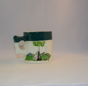
Mug Stoneware
This ceramic mug is titled "Bill Bogong's Mug" in honour of one of Australia's Scouting (Rovers) notable office holders, Mr.W.F."Bill" Waters. He was born on 22nd August 1897 in Taralgon, Victoria, Australia and died 8th October 1968 in Fitzroy, Victoria. He was instrumental in the Rovers building two chalets in the Victorian Alps. The Victorian Award of the National Rover Service Award(1980) has been named after Bill Waters. Bill Waters was also the leader of the first team that climbed Mount Bogong in winter in 1929. Also was part of rescue team of what is now know as the Cleve Cole tragedy on Mt Bogong in the mid 1930's. There is also a water fall named after him Waters Falls on the Bogong High Plains. W.F."Bill" Waters aka "Bill Bogong" (Bogong mountain, were his ashes were scattered), was not only a prominent bush walker (Melbourne Walking Club) of the high country (Victorian Alps) but was instrumental in establishing two Chalets. One of these Chalets was the first one to be built on the Bogong High Plains. This item, "Bill Bogong's Mug" is what the Flinders Petrie(famous English Egyptologist/Archaelogist) Rover Crew(formed in 1940) presented newly invested members of the exclusive(200 membership) Alpine Rover Crew. The Melbourne Walking Club has a long history with the Victorian High Plains area, of which the Kiewa Valley is an integral part of the Victorian Alpine Region. Due to the connections Bill Waters has with the Bogong High Plains and Mt Bogong this cup has a lot of significance to the social history of the area.. Round glazed stoneware mug, white in colour, with a heritage green coloured band covering the top rim and handle. Written inscription on the front "Bill Bogong's Mug" in large print and beneath it, in smaller print, "with compliments from Flinders Petrie Rover Crew" The other side of the mug is a free hand landscaped drawing of green bush and blue hills with a tree supporting a tent and a camp fire (with smoke rising from it).To the left of the inscription is the Scout (Rover) emblem coloured black with an unraveled and unwritten signage scroll fowler ceramics, local alpine history, alpine rovers, scouts, mugs, mt bogong, bogong high plains -
 Kiewa Valley Historical Society
Photograph of Clover Power Station, No. 3 Power Station, after May 1944
In July, 1941 work commenced on the site of the power station with the building of a coffer dam and excavation for the power station building and machine foundations followed. Work proceeded, and the access bridge, transformer foundations and transfer track were completed in April, 1943 and the power station building in May, 1943. Installation of the machines was then proceeded with and No. 1 machine was run for the first time in June 1944. No. 2 machine was completed in April, 1944 and placed in service in May.A pictorial record for the State Electricity Commission of the first Power Station commissioned in the Kiewa Hydro Electric Scheme.Black and white photograph of the bridge and entrance to No. 3 Power Station (Clover Power Station).Handwritten on back of photograph in blue ink "No. 3 Power Station".clover, power station, machine, kiewa scheme -
 Eltham District Historical Society Inc
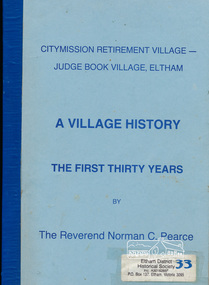
Book, Citymission Retirement Village - Judge Book Village, Eltham: A Village History; the first thirty years / The Reverend Norman C. Pearce, 1986
CityMission Retirement Village, also known as Eltham Retirement Centre, also formerly known as Judge Book Memorial Village, was officially opened on Sunday 28 October 1956. This history documents the first thirty years through to 1986. Founded by the Melbourne City Mission, the significant early history of the "village for the aged" is documented including the various challenges faced including ongoing expansions and building develoment needs and impacts of flooding from the nearby Diamond Creek. It mentions some people associated with the organisation with reference to the Eltham Auxillary which was a group of Eltham residents formed to support the organisation and its residents through activity and fundraising efforts.Softcover; 60p.judge book village, retirement village, melbourne citymission, eltham, aged care, seniors, social service, older people, housing -
 Eltham District Historical Society Inc
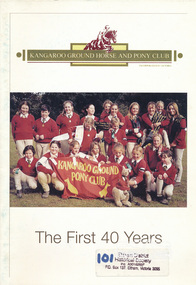
Book, Kangaroo Ground Pony Club, Kangaroo Ground Horse and Pony Club - the first 40 years, 2007
Kangaroo Ground Pony Club aims are to encourage young people to ride and to learn to enjoy all approved types of sport connected with horses and riding. This book includes details of the history, established in 1964 and the dedicated and enthusiastic families involved in the fundraising, building and events run by the club.kangaroo ground, pong club, horses -
 Eltham District Historical Society Inc
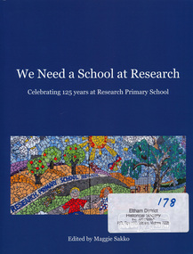
Book, Research Primary School, We Need a School at Research - celebrating 125 years at Research Primary School, edited by Maggie Sakko, 2014
History of Research Primary School, north-eastern suburb of Melbourne. Begins with condensed version of the 1989 history of first 100 years, then covers 25 years 1989-2014: buildings and facilities, principals, teachers, students, uniform, School Council, Parents Group, out of school care, curriculum, and special events such as productions and camps. Registers of principals, staff and students are included. Numerous photographs are included.100 pages : illustrations, portraits ; 28 cm.ISBN 9780646925172research (vic.) -
 Eltham District Historical Society Inc
Ledger, Eltham Road District. Assessment for the Year ending Oct. 14th, 1858, 1857c
The Eltham Roads Board was established in 1856. This is a unique significant record of early settlers in the Shire of Eltham. One of 6 early rate books. This is among the oldest items in the EDHS collection. An article in the Eltham and Whittlesea Shires Advertiser Friday 21 Nov 1941 Page 5 titled: District's Early History states: "The first rate book which is still in existence at the Shire Office is for the year ending October 14, 1858 and is probably the best record possible to indicate the development of the district. At the time properties were rated as follows: Cultivated land. 6d. per acre; pasture land, 1d. per acre: estimated annual value of buildings, etc., 6d in the (pound). The total amount of rate recorded for the year was (pounds)153/14/8. Properties were described as being situated at Lower Plenty, Yarra Yarra, Eltham, Lower Eltham, Kangaroo Ground, Yarra Flats, Diamond Creek and the Yarra."Ledger with printed columns: Number, Name of Occupier, Description, Where situated, Cultivated land, Pasture land, Estimated annual value of buildings, Rate, Remarks. Ledger filled out by hand with 152 entries (not alphabetically arranged). A number of blank pages are included. Copy re-bound in green hard leather look card by Arnall & Jackson Pty Ltd Brunswick, 1968 Inside cover includes a compliments slip taped to the cover from Arnall & Jackson Pty Ltd. with handwritten inscription: "Ian, I hope the hysterical society doesn't get historical about this". Organised 1968 I. Maynard Inside cover includes pasted printed note: RATE OF ASSESSMENT AS FOLLOWS: Cultivated land 6d per acre Pasture land 1 per acre Estimated Annual Value of Buildings, &c., 6d. in the Pound eltham roads board, rate book, rate payers, transaction, pioneers, settlers, 1858, assessment ledger, eltham road district, public records office victoria (prov), rate books, shire of eltham archives -
 Eltham District Historical Society Inc
Ledger, Eltham Road District. Assessment for the Year ending Oct. 14th, 1859, 1858c
The Eltham Roads Board was established in 1856. This ledger includes the signature of Road Board Secretary and Collector Wingrove, a significant person in Eltham's early history. This is a unique significant record of early settlers in the Shire of Eltham. One of 6 early rate books. This is among the oldest items in the EDHS collection. An article in the Eltham and Whittlesea Shires Advertiser Friday 21 Nov 1941 Page 5 titled: District's Early History states: "The first rate book which is still in existence at the Shire Office is for the year ending October 14, 1858 and is probably the best record possible to indicate the development of the district. At the time properties were rated as follows: Cultivated land. 6d. per acre; pasture land, 1d. per acre: estimated annual value of buildings, etc., 6d in the (pound). The total amount of rate recorded for the year was (pounds)153/14/8. Properties were described as being situated at Lower Plenty, Yarra Yarra, Eltham, Lower Eltham, Kangaroo Ground, Yarra Flats, Diamond Creek and the Yarra."Ledger with printed columns: Number, Name of Occupier, Description, Where situated, Cultivated land, Pasture land, Estimated annual value of buildings, Rate, Remarks, Arrears collected, excused, unoccupied, uncollected and amount actually collected. Ledger filled out by hand with 173 entries (not alphabetically arranged). A number of blank pages are included. Inside cover includes pasted printed note: RATE OF ASSESSMENT AS FOLLOWS: Cultivated land 6d per acre Pasture land 2d per acre Unalienated Pasture Land 8d per Acre Estimated Annual Value of Buildings, &c., 6d. in the Pound eltham roads board, rate book, rate payers, transaction, pioneers, settlers, wingrove, 1859, assessment ledger, eltham road district, public records office victoria (prov), rate books, shire of eltham archives -
 Eltham District Historical Society Inc
Ledger, Eltham Road District. Assessment for the Year ending Oct. 14th, 1860 (Version 1), 1859c
The Eltham Roads Board was established in 1856. This is a unique significant record of early settlers in the Shire of Eltham. One of 6 early rate books. This is among the oldest items in the EDHS collection. An article in the Eltham and Whittlesea Shires Advertiser Friday 21 Nov 1941 Page 5 titled: District's Early History states: "The first rate book which is still in existence at the Shire Office is for the year ending October 14, 1858 and is probably the best record possible to indicate the development of the district. At the time properties were rated as follows: Cultivated land. 6d. per acre; pasture land, 1d. per acre: estimated annual value of buildings, etc., 6d in the (pound). The total amount of rate recorded for the year was (pounds)153/14/8. Properties were described as being situated at Lower Plenty, Yarra Yarra, Eltham, Lower Eltham, Kangaroo Ground, Yarra Flats, Diamond Creek and the Yarra."Ledger with printed columns: Number, Name of Occupier, Description, Where situated, Cultivated land, Pasture land, Estimated annual value of buildings, Rate, Remarks, Arrears collected, excused, unoccupied, uncollected and amount actually collected. Ledger filled out by hand with 177 entries (not alphabetically arranged). A number of blank pages are included. Inside cover includes pasted printed note: RATE OF ASSESSMENT AS FOLLOWS: Cultivated land 6d per acre Pasture land 2d per acre Unalienated Pasture Land 8d per Acre Estimated Annual Value of Buildings, &c., 6d. in the Pound eltham roads board, rate book, rate payers, transaction, pioneers, settlers, wingrove, 1860, assessment ledger, eltham road district, public records office victoria (prov), rate books, shire of eltham archives -
 Eltham District Historical Society Inc
Ledger, Eltham Road District. Assessment for the Year ending Oct. 14th, 1860 (Version 2), 1859c
The Eltham Roads Board was established in 1856. This is a unique significant record of early settlers in the Shire of Eltham. One of 6 early rate books. This is among the oldest items in the EDHS collection. An article in the Eltham and Whittlesea Shires Advertiser Friday 21 Nov 1941 Page 5 titled: District's Early History states: "The first rate book which is still in existence at the Shire Office is for the year ending October 14, 1858 and is probably the best record possible to indicate the development of the district. At the time properties were rated as follows: Cultivated land. 6d. per acre; pasture land, 1d. per acre: estimated annual value of buildings, etc., 6d in the (pound). The total amount of rate recorded for the year was (pounds)153/14/8. Properties were described as being situated at Lower Plenty, Yarra Yarra, Eltham, Lower Eltham, Kangaroo Ground, Yarra Flats, Diamond Creek and the Yarra."Ledger with printed columns: Number, Name of Occupier, Description, Where situated, Cultivated land, Pasture land, Estimated annual value of buildings, Rate, Remarks, Arrears collected, excused, unoccupied, uncollected and amount actually collected. Ledger filled out by hand with 177 entries (not alphabetically arranged). A number of blank pages are included. This version was slight changes to version one. Inside cover includes pasted printed note: RATE OF ASSESSMENT AS FOLLOWS: Cultivated land 6d per acre Pasture land 2d per acre Unalienated Pasture Land 8d per Acre Estimated Annual Value of Buildings, &c., 6d. in the Pound eltham roads board, rate book, rate payers, transaction, pioneers, settlers, 1860, assessment ledger, eltham road district, public records office victoria (prov), rate books, shire of eltham archives -
 Eltham District Historical Society Inc
Ledger, Eltham Road District. Assessment for the Year ending Oct. 14th, 1861, 1860c
The Eltham Roads Board was established in 1856. This is a unique significant record of early settlers in the Shire of Eltham. One of 6 early rate books. This is among the oldest items in the EDHS collection. An article in the Eltham and Whittlesea Shires Advertiser Friday 21 Nov 1941 Page 5 titled: District's Early History states: "The first rate book which is still in existence at the Shire Office is for the year ending October 14, 1858 and is probably the best record possible to indicate the development of the district. At the time properties were rated as follows: Cultivated land. 6d. per acre; pasture land, 1d. per acre: estimated annual value of buildings, etc., 6d in the (pound). The total amount of rate recorded for the year was (pounds)153/14/8. Properties were described as being situated at Lower Plenty, Yarra Yarra, Eltham, Lower Eltham, Kangaroo Ground, Yarra Flats, Diamond Creek and the Yarra."Ledger with printed columns: Number, Name of Occupier, Description, Where situated, Cultivated land, Pasture land, Estimated annual value of buildings, Rate, Remarks, Arrears collected, excused, unoccupied, uncollected and amount actually collected. Ledger filled out by hand with 185 entries (not alphabetically arranged) and summary section. A number of blank pages are included. Inside cover includes pasted printed note: RATE OF ASSESSMENT AS FOLLOWS: Cultivated land 6d per acre Pasture land 2d per acre Unalienated Pasture Land 8d per Acre Estimated Annual Value of Buildings, &c., 6d. in the Pound eltham roads board, rate book, rate payers, transaction, pioneers, settlers, 1861, assessment ledger, eltham road district, public records office victoria (prov), rate books, shire of eltham archives -
 Eltham District Historical Society Inc
Ledger, Eltham Road District. Assessment for the Year ending Oct. 14th, 1862, 1861c
The Eltham Roads Board was established in 1856. This is a unique significant record of early settlers in the Shire of Eltham. One of 6 early rate books. This is among the oldest items in the EDHS collection. An article in the Eltham and Whittlesea Shires Advertiser Friday 21 Nov 1941 Page 5 titled: District's Early History states: "The first rate book which is still in existence at the Shire Office is for the year ending October 14, 1858 and is probably the best record possible to indicate the development of the district. At the time properties were rated as follows: Cultivated land. 6d. per acre; pasture land, 1d. per acre: estimated annual value of buildings, etc., 6d in the (pound). The total amount of rate recorded for the year was (pounds)153/14/8. Properties were described as being situated at Lower Plenty, Yarra Yarra, Eltham, Lower Eltham, Kangaroo Ground, Yarra Flats, Diamond Creek and the Yarra."Ledger with printed columns: Number, Name of Occupier, Description, Where situated, Cultivated land, Pasture land, Estimated annual value of buildings, Rate, Remarks, Arrears collected, excused, unoccupied, uncollected and amount actually collected. Ledger filled out by hand with 184 entries (not alphabetically arranged) and summary section. A number of blank pages are included. Inside cover includes pasted printed note: RATE OF ASSESSMENT AS FOLLOWS: Cultivated land 6d per acre Pasture land 1/2d per acre Unalienated Pasture Land 1/28 per Acre Estimated Annual Value of Buildings, &c., 6d. in the Pound eltham roads board, rate book, rate payers, transaction, pioneers, settlers, 1862, assessment ledger, eltham road district, public records office victoria (prov), rate books, shire of eltham archives -
 Eltham District Historical Society Inc
Ledger, Eltham Road District. Assessment for the Year ending Oct. 14th, 1863, 1862c
The Eltham Roads Board was established in 1856. This is a unique significant record of early settlers in the Shire of Eltham. One of 6 early rate books. This is among the oldest items in the EDHS collection. An article in the Eltham and Whittlesea Shires Advertiser Friday 21 Nov 1941 Page 5 titled: District's Early History states: "The first rate book which is still in existence at the Shire Office is for the year ending October 14, 1858 and is probably the best record possible to indicate the development of the district. At the time properties were rated as follows: Cultivated land. 6d. per acre; pasture land, 1d. per acre: estimated annual value of buildings, etc., 6d in the (pound). The total amount of rate recorded for the year was (pounds)153/14/8. Properties were described as being situated at Lower Plenty, Yarra Yarra, Eltham, Lower Eltham, Kangaroo Ground, Yarra Flats, Diamond Creek and the Yarra."Ledger with printed columns: Number, Name of Occupier, Description, Where situated, Cultivated land, Pasture land, Estimated annual value of buildings, Rate, Remarks, Arrears collected, excused, unoccupied, uncollected and amount actually collected. Ledger filled out by hand with 181 entries (not alphabetically arranged) and summary section. A number of blank pages are included. Inside cover includes pasted printed note: RATE OF ASSESSMENT AS FOLLOWS: Cultivated land 6d per acre Pasture land 1/2d per acre Unalienated Pasture Land 1/28 per Acre Estimated Annual Value of Buildings, &c., 6d. in the Pound eltham roads board, rate book, rate payers, transaction, pioneers, settlers, 1863, assessment ledger, eltham road district, public records office victoria (prov), rate books, shire of eltham archives -
 Eltham District Historical Society Inc
Magazine, Sun News-Pictorial, Bush Fires: A pictorial survey of Victoria's most tragic week, January 8-15, 1939, 1939
THE WEEK REVIEWED (Article; Bush Fires: A pictorial survey of Victoria's most tragic week, January 8-15, 1939. Published in aid of the Bush Fire Relief Fund by the Sun News-Pictorial in co-operation with its newsagents, pp2-3) THE fiercest bush fires Australia has known since its discovery are quiescent at the moment, and Victoria, in the comparative coolness of the change which came with rain on Sunday night, has begun·to count its losses. In the fiery eight days, from Sunday to Sunday, at least sixty-six men, women and children have lost their lives in forest fires, or have succumbed to burns and shock; many others have died from heat; and several serious cases of burns are being treated in hospitals. Two babies in Narrandera district have died, and ten others are in hospital, because of milk soured by the record temperatures of those eight days. Forest damage totals at least a million pounds, and incalculable damage has been done to the seedlings which were to have been the forests of the future. Water conservation will be seriously affected by the silting-up of reservoirs and streams from which protective timber has been taken by the all-engulfing flames. More than a thousand houses have been destroyed, and these, with 40 mills, and schools, post-offices, churches, and other buildings, represent a loss of at least half a million. At least 1500 are homeless. For their aid, money raised in appeals has now passed the £50,000 mark, and the biggest relief organisation ever set up in peace time has swung into operation. The First Hint Victoria's first hint of what was to come appeared on Sunday, January 8, when most parts of the State awoke to find a blistering day awaiting. At 12.20 p.m., when the thermometer reached its highest for the day, 109.6 degrees, the first fire victims were at that moment going to their death on a bush track five feet wide off the main road to Narbethong. They were the forestry officers Charles Isaac Demby and John Hartley Barling, who went to warn Demby of his danger when he parted from his companions, and was himself surrounded by the treacherous fire. It was not until 8 o'clock next morning that the tragic news was flashed throughout the State. Searchers found the two charred bodies close together, one seeking protection in the nook of two logs. Barling's watch had stopped at 1.20. In the meantime, tragedy was spreading its cloak. By Monday, big fires were raging at Toolangi, Erica, Yallourn, Monbulk, Frankston, Dromana, Drouin South, Glenburn, and Blackwood, with smaller outbreaks at many other centres. In the ensuing week, while women and children were evacuated as fast as the flames would permit, Erica-scene of the 1926 fire disaster-thrice escaped doom by a change of wind. Indeed, those who have been in the fire country these past days say that the numbers of times a change of wind has saved towns from destruction is amazing. In the towns they speak of miracles. Monday's Miracles The escapes from Monett's Mill at Erica and from the Hardwood Company's Mill at Murrindindi, near where Demby and Barling went to their death, were Monday's miracles. Twenty came out alive from each mill. At the first a 60ft. dugout provided an oven-like refuge; at the second, 12 women and children survived in the smoke-filled gloom of a three-roomed cottage while their eight men, their clothes sometimes afire, poured water on the wooden walls. Three houses out of ten remained when the fire had passed. Record Temperatures Sunday had been the hottest Melbourne day for 33 years; Monday dropped to a 76.1 degree maximum; but Tuesday dawned hotter than ever, the mercury reaching 112.5. By now rumor was racing ahead of fact; whole towns were being reported lost; the alarm was raised for scores of missing persons. But fact soon overtook rumor, and within a few days the staggering toll began to mount to a figure beyond the wildest imaginings of the panic-stricken. Six died from heat on this torrid Tuesday, and the fires spread in a wide swathe from south-west to north-east across the State. Fish died in shallow streams. A curtain of smoke hid the sky from all Victoria, and hung far out to sea. It alarmed passengers on ships. On the Ormonde, on the voyage to Sydney from Burnie, women ran on deck, believing fire had broken out in the hold. Days later the smoke reached New Zealand. In Melbourne thousands of fire-volunteers were leaving in cars: vans, motor-buses-anything reliable on wheels-to aid the country in its grim fight. In the fires at Rubicon and. Narbethong, seventeen were facing death this day. But not till Wednesday, when Melbourne breathed again in a cool change, while the country still sweltered in temperatures up to 117 degrees, did the news come through the tree blocked roads. A woman and her little daughter, trapped on the road, were among those who died. Their bodies, and those of menfolk with them, were found strewn out at intervals along the road, where the furnace of the surrounding fire had dropped them in their tracks as they ran. Twelve died at a Rubicon mill, five on the road at Narbethong. At Alexandra, not far distant, a baby was born while the fires raged, and stretcher-bearers brought in the injured. On Thursday the State Government voted £5000 for the relief of fire victims. The Governor (Lord Huntingfield) and the Lord Mayor (Cr. Coles) visited some of the stricken areas, and dipped into their pockets personally. Later, the City Council, too, voted £5000. Friday, The 13th Friday, the Thirteenth, justified its evil name. A blistering northerly came early in the morning, presaging destruction, and forcing the mercury to a new record of 114 degrees. Racing fires killed at least ten in those terrible 12 hours. Four children were engulfed in the furnace at Colac. Panic drove them, uncontrollable, into the smoke-filled road when the fire raced down behind their home. They choked to death. In other parts fires were joining to make fronts of scores of miles. Kinglake was being menaced on two fronts, £60,000 worth of timber was going up in smoke in Ballarat district. Warburton was surrounded. Residents at Lorne, favoured resort, were being driven to the sea-front by a fire which destroyed at least 20 homes. Healewille. with flames visible from the town at one stage, was in a trough between two fires which burned four guest-houses, seven homes and left its surrounding beauty-spots wastes of bowed-over, blackened tree-fern fronds; with its famous Sanctuary, however, intact. Most of Omeo was destroyed this black day: Noojee. while 200 residents crouched in the river, was being reduced to a waste of buckled iron and smoking timber; Erica was once again saved by a change of wind. Beneath a pall of smoke, the Rubicon victims were buried at Alexandra. Friday night and the early hours of Saturday saw the streets of beleagured towns strewn with exhausted fire-fighters. Their flails beside them, ready for the next call, they lay where exhaustion overtook them-on footpaths, beside lamp-posts, in gutters, in cars, under trucks. Saturday's dawn brought clear skies and lower temperatures in many parts, and from the burnt-out areas came a great rush of tragic reports. The death-roll rushed past the fifty mark with incredible speed. Some had been trapped on roads, others at mills; some, after burying their treasures, had clung too long to the places they had made their homes for many years. Four men lost their lives because one went back for his dog. By Sunday, when the first of the saving rain came, nearly another score of names had been added to the list.Newspaper magazine, 48 pages (incl. covers). Fully digitised and searchable PDFPublished in aid of the Bush Fire Relief Fund by the Sun News-Pictorial in co-operation with its newsagents.bushfires, 1939 bushfires, black friday, warrandyte -
 Eltham District Historical Society Inc
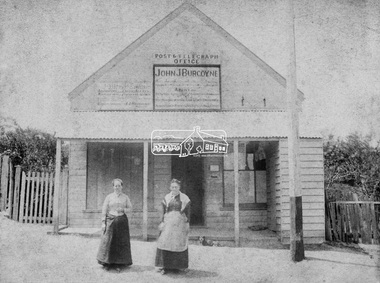
Photograph, Hunniford’s Eltham Post Office, Main Road near Bridge Street, Eltham, c.1888
Sepia photograph of Hunniford’s Eltham Post Office, Main Road near Bridge Street, Eltham, c.1888 (Postmistress Anne Hunniford possibly on left). The building originally had a shingle roof. Anne Hamilton born 1814 Co Tyrone, Ireland married Michael Head Burgoyne (1820-1843) in 1839, Co. Tyrone, Ireland. They had two children, Charlotte Caroline (1840) and John James Thomas Neville (Londonderry, Ireland 1844) Whilst pregnant with John, husband Michael died. Following John’s birth, she emigrated to Victoria, Australia where she married Thomas Hunniford in 1854. Daughter Anne Jane Hunniford was born in Eltham in 1855. Anne (Annie) Jane Hunniford and John James Thomas Neville Burgoyne were half siblings. In the mid 1860s Annie Hunniford succeeded her father, Thomas Hunniford as Post Mistress for Eltham. Photo dated based on advertising on façade of the building by Annie’s half-brother, John James Thomas Burgoyne promotes his services as the area manager for John M’Ewan and Co, Auctioneers as well as him being agent for the National Mutual Life Association of Australasia, National Insurance Company of Australasia, Federal Mutual Livestock Association of Australasia, and as a House, Land, Estate, Insurance and Financial agent. This was the time period that he placed advertising for same in the local paper. Australia Post: Gold brought life to the township - Diamond Valley News, Tuesday July 2, 1985, p17 On February 1, 1854, the first Eltham Post Office was established, commencing an association between the township and the Postmaster-General's Department that has continued for 131 years. At that time, the number of permanent residents would have been fairly small, probably less than 200. The discovery of gold in June 1851, at Anderson’s Creek, some five miles away, and later at Caledonia Diggings, Queenstown (now known as St Andrews), about 14 miles to the north-east, brought large numbers of prospectors passing through the township, hopefully culling the creeks and gullies for the precious metal. This additional "floating population" brought a greater demand for supplies and for communication with the outside world, and so it helped in the development of Eltham. Today, Eltham is a thriving township. It boasts an excellent shopping centre, municipal offices, court house. post office and many other amenities. Eltham continued to develop at a leisurely pace. During 1860, a total of just over 8000 postal articles were handled at the Eltham Post Office. By 1862, the mail route was "to and from Melbourne by way of Eltham and Kangaroo Ground, three times a week, by coach". There was also a branch mail that operated between Eltham and Greensborough, three times weekly. This was also conveyed by coach. Some time between 1864 and 1868 the management of the post office passed from Thomas Hunniford to his daughter, Miss Anne Hunniford, who managed the Eltham Post Office until her death in 1928. A big improvement in communication was provided for Eltham residents when a telegraph office was established at the post office in 1877. During 1923 a manual telephone exchange was provided at Eltham, the first two subscribers being J.J. O’Connor and Eltham Police Station. In 1949 the manual exchange was replaced by an automatic exchange and there were some 150 subscribers. Following the death of postmistress Miss Anne Hunniford in 1928, B.M. Burgoyne was placed temporarily in charge of the office. In 1929, J. N. Burgoyne was appointed postmaster, and he in turn was succeeded by H. C. Burgoyne in 1951. The post office was moved to a new site in 1954, but continued under the charge of Mr Burgoyne. In January 1958 there was a further change of site when the post office was raised to official status and transferred to new premises in Main Rd. William Donoghue was acting postmaster when the new office was opened. In March 1958 Mr W.E. Tovey was appointed postmaster, followed by Douglas McG. Gilmour in 1959. William Donoghue was fully appointed in 1966 and Barry Reichelt followed in 1973, prior to the present postmaster, Peter Jolly in November 1982. Peter is a young man with 18 years' experience. He commenced his training as a postal clerk at the training school in Melbourne in 1968 and was promoted to postal clerk at the Brunswick Post Office in 1969. He was finally transferred as postmaster to Fawkner Post Office in 1980. He has been at Eltham Post Office for the past 2½ years. He is married with one child and lives in Montmorency. The Eltham Post Office employs a staff of 21, of whom seven are indoor staff, 12 are postmen and two are drivers. The postmen in Eltham have an uphill battle delivering mail because of the hilly terrain. Nine of the postmen deliver mail on motorbikes, and the two delivery vans are both four wheel drives. Eltham Post Office services basically a residential area, with deliveries to 5600 homes. This is growing at the rate of 600 homes every 18 months, i.e. about 32 homes per month. At the present rate we will need a new postman every 18 months.Sepia photograph (two copies plus two black and white enlargements)Shop originally had a shingle roofpost office, eltham, main road, anne jane hunniford (1855-1928), federal mutual live stock insurance association of australasia, federal mutual livestock association of australasia, john j burgoyne, john m'ewan and co. auctioneers, national insurance company of australasia, national mutual life association of australasia -
 Eltham District Historical Society Inc
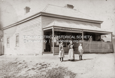
Photograph, Baker and Grocer shop, cnr. Main Road and York Street, Eltham, c.1902
Baker and Grocer store, cnr. Main Road and York Street, Eltham, early 1900s. Sign on side of building "Baker, Grocer & Summer Drinks" This image appears to be of the baker/grocery store after it was purchased in 1902 by Mrs Sarah Burgoyne and her husband, John James Thomas Burgoyne. It is possible that Mrs Sarah Burgoyne is the lady in front of the store with her eldest daughter, Charlotte and youngest son, James. Another daughter (Frances) and the family dog are watching from the doorway. In 1902 Mrs Sarah Burgoyne purchased from Wilfred Henry Johnston, the property on the southern corner of Main Road and York Street, Eltham, which consisted of a store and bakery establishment occupied by Mr. Luther Haley whose lease had expired around the same time. Mr. Haley had not been prepared to leave as he was unable to secure at Eltham a suitable house in which to carry on his business. Wilfred Johnston applied for an eviction of Hayley, which was heard at Eltham Courthouse in August 1902. Hayley advised he was building a place near the railway station which he expected to be done in about three weeks’ time. The court gave him the three weeks to vacate. Hayley’s new premises near the station became the present shopping district’s first shop and he ran it successfully till 1917 when the family moved to Clifton Hill, and he became a publisher. Their eldest child Leslie drowned in the Diamond Creek in early 1904, aged 12.Sepia photograph mounted on cardeltham, eltham bakery, grocer, john james thomas burgoyne, main road, sarah jane burgoyne (nee benson), summer drinks, york street -
 Eltham District Historical Society Inc
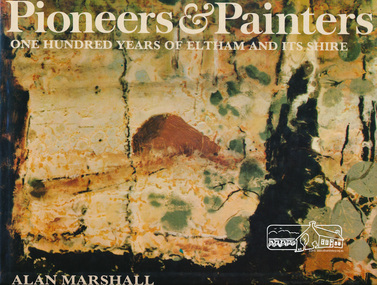
Book, Alan Marshall (1902-1984), Pioneers & painters : one hundred years of Eltham and its shire, 1971
Jacket painting by Clifton Pugh. "Eltham Shire is a well known as a district in which a large number of painters, sculptors, potters, writers and other creative people, The early settlers were, for the most part, resourceful and far-sighted ; the present residents are no less so. Mention the name Eltham and many things spring to mind ; conservation ; the integration of architecture with the environment ; mud-brick buildings; Montsalvat - the list is endless. In 1971, the centenary of the Shire's birth, the Council felt that the publication of a history would fittingly mark more than a century of achievement.." - Dust jacket. Contents: The Beginning Kangaroo Ground Education at Kangaroo Ground The Days of Gold Queenstown Panton Hill The Pioneer Women Christmas Hills and Yarra Glen Eltham Education at Eltham and Research Kinglake Hurstbridge by Sheila Ferguson Montmorency and Lower Plenty The New Way of Life Old Identities Eltham in modern times Educationalists and Writers Earth building in Eltham Early Painters by Peter Glass Painters Today by Peter Glass Warrandyte painters and Potters by Peter Glass Wildlife Present day This book provides a comprehensive history of the former Shire of Eltham and its first one hundred years. Hardback Book with Dust Jacket - 144 p. : illus. (part col.) ; ISBN 0170019489 eltham, alan marshall, shire of eltham, clifton pugh -
 Eltham District Historical Society Inc
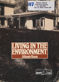
Book, Alistair Knox 1912-1986, Living in the environment / Alistair Knox, 1978
First published in 1975Paperback; 150 pages : illustrations ; 24 cm.ISBN 090813648X [written on flyleaf] To Norma Travis(?) from Alistair Knox 2/12/78houses, buildings, mudbrick, mud brick construction, alistair knox -
 Eltham District Historical Society Inc
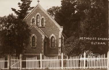
Photograph, Eltham Methodist Church, 1909, 1909
Situated at 810 Main Road on the corner of John Street. The Church was surrounded by a picket fence and tall pine trees. The Church was built by George Stebbings in the 1850s and is an example of fine craftmanship. Formerly Wesleyan, Methodist then Uniting church; the foundations of the church building were constructed with stone from the walls of the first Eltham State Primary School (No. 209) building which collapsed in 1874 and were purchased by Robert David Taylor. REVISED STATEMENT OF SIGNIFICANCE, CONTEXT, 2010 via Victorian Heritage Database What is significant? The 1880 bichromatic brick church and the surrounding site to the title boundaries. How is it significant? The church is architecturally, historically, socially and spiritually significant to the Shire of Nillumbik. Why is it significant? The church is architecturally significant as a finely detailed example of a brick 19th century rural community church, one of only four in the Shire (Criteria E & B). The church is historically significant as an important link with the time when Eltham was a small, insular country settlement. Also for the historical evolution visible in the complex, with the modest 1880s church and larger red brick rear hall from the early 20th century as a reflection of population growth in the area (Criterion A). The church is historically, spiritually and socially significant because it has played, and continues to play, an important part in the spiritual and social life of the community (Criterion G).Sepia postcard of Eltham Methodist Church, 1909eltham, methodist church, church, state school no. 209, eltham state school, robert david taylor, eltham uniting church, uniting church, wesleyan church -
 Eltham District Historical Society Inc
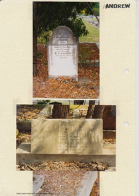
Folder, Andrew
James Andrew Kangaroo Ground, 1870 "James Andrew, Whittlesea, born in East Palford, Devonshire, England, in 1827, arrived in Adelaide in February 1850 per ship Lady McCaughton and almost immediately sailed in a coasting vessel to Melbourne, where the first work he undertook was clearing earth from a stone quarry in Collingwood. He next carried stones for masons engaged in building the Bishop’s Palace, and then was employed in Cambellfield mowing hay. He was at Saltwater River on Black Thursday, and afterwards took a little farm at Darebin Creek, remaining there for four years. He went up to Kangaroo Ground in 1859 and lived there until he bought his present property at Whittlesea, a farm of between 300 and 400 acres. He has been twice married, and had a family of six children." "Andrew, W. B. Eltham, is a native of England, born in 1822. Coming out to Australia in 1842, he lived in Brighton, Victoria for fifteen years, when he re-visited England for a year. Returning to Victoria fourteen or fifteen years ago, he commenced storekeeping at Eltham, where he has carried on that business ever since. Mr Andrew has always taken a lively interest in the public affairs of town and district” from "Victoria and its Metropolis: Past and Present" written in 1888 by Alexander Sutherland. Chapter 19, "The Upper Yarra District" pages [402] - 415. Includes descriptions of some townships and short biographies of local residents. Page 405 Folder of information on James Andrew, Trustee Kangaroo Ground Cemetery, Kangaroo Ground 1870 William Bravery Andrew, Eltham, 1870s-1880s Ernest James Andrew, Eltham, Eltham Shire Councillor, 1920s-1950 and Ellen Matilda Brown Andrewjames andrew, pioneer, kangaroo ground, ernest james andrew, william bravery andrew, ellen andrew, eltham cemetery, biography, ellen harper andrew (nee clarke), ellen matilda andrew (nee brown), eltham war memorial gate, eltham war memorial trust -
 Eltham District Historical Society Inc
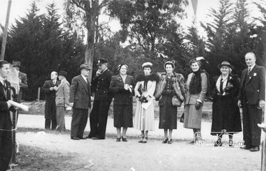
Photograph, Peter Bassett-Smith, Cermony for turning of the first sod, Eltham War Memorial Infant Welfare Centre Building, 18 Jul. 1950
Major Frank D. Stevens, RSL President and school boy Albert Feldbauer (youngest child of the children of the soldier fathers attending a school in the district) at the ceremony of turning the first sod for the Eltham War Memorial Infant Welfare Centre Building. Major Frank Stevens was later the Scout Commissioner of Heidelberg City Scout Groups from Fairfield railway gates to the intersection of Main Road at Hurstbridge.Eight original prints (21.5 x 18 cm - plus three duplicated) and one 10 x 15 cm colour print reproduction from a negative taken of original printalbert feldbauer, ceremonies, eltham, eltham war memorial building, fred griffiths, cr. fred squire, main road, major frank stevens, memorials, mrs dave lyon, mrs rains, war memorials, eltham infant welfare centre -
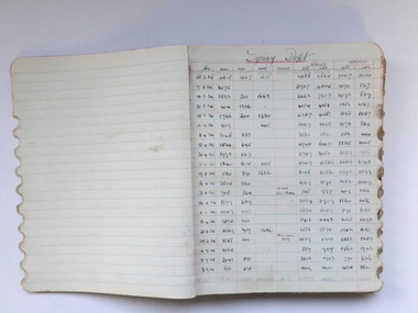 Warrnambool and District Historical Society Inc.
Book, Ledger Woollen Mill - Departmental Weekly Reports, 1930s
This is an exercise book, probably purchased from a local stationers, which was used at the Warrnambool Woollen Mill in the 1930s to record weekly operations in each of the Mill’s departments. The Warrnambool Woollen Mill was established in 1910 in South Warrnambool by a local company, with the building erected on a site that formerly housed another woollen mill destroyed by fire in 1882. The Warrnambool Woollen Company operated successfully for many years with over 700 employees in the 1940s and a good national reputation for quality goods. It made blankets and other woollen goods and was the first company in Australia to manufacture electric blankets. In the 1960s the mill was sold to the Dunlop Company and for the next thirty years it was bought and sold several times, finally closing in 2000 after 90 years of operation. This exercise book is of some importance as it belonged to the Warrnambool Woollen Mill, a dominant and important industry in Warrnambool for most of the 20th century. Many present and past residents of Warrnambool and district were employed at the Mill. It is one of many items in our collection that outlines the mill’s day-to-day operations and contains information that may be useful to researchers. This is an exercise book which belonged to the Warrnambool Woollen Mill and appears to be two exercise books joined together as there is a black cover in the middle of the pages. The original black covers at the front and back are missing. The pages are lined in blue and most used pages have ruled red lines. The entries are in black ink and include the date and other information on the processes of the spinning, carding, scouring etc. The page edges on the right have been serrated in an oval shape to make tabs for the various departments in the Mill – Engineers, Scouring. Dyeing, Warehouse etc. and the book contains weekly entries regarding Mill operations from 1930 to 1936.Edge of book: ‘Records’warrnambool woollen mill, history of warrnambool -
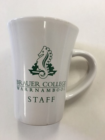 Warrnambool and District Historical Society Inc.
Mug, Brauer College, Early 21st century
This is a souvenir mug from Brauer College, Warrnambool. It is intended to be used by staff members from the school. Brauer College is in Caramut Road, Warrnambool and began as the Warrnambool Technical School which was established in Timor Street in 1913. The first Principal of the School, John King, served for 29 years. Additional buildings were constructed at the site over the ensuing years. In 1965 Warrnambool North Technical School was established at Albert Park (now merged with Warrnambool High School to become today’s Warrnambool College). In 1973 Warrnambool Technical School moved from the Timor Street site and re-located to Caramut Road. At the start of 1990 the school was renamed Brauer School, with the name taken from a prominent 20th century doctor in the town, Dr Alfred Brauer. Today the school is a secondary school offering a comprehensive range of subjects. This item is of minor interest of an inexpensive souvenir of Brauer College WarrnamboolThis is a souvenir china mug from Brauer College, Warrnambool. It is white with a green Brauer College sea horse emblem and the words ‘Brauer College, Warrnambool Staff’. The words ‘Brauer College’ are underlined. ‘Brauer College Warrnambool Staff’ ‘Made in China’ dr a. brauer, brauer college, history of warrnambool -
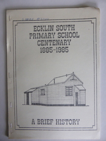 Warrnambool and District Historical Society Inc.
Booklet, Ecklin South Primary School 1885-1985, 1985
This is a short history of the Ecklin South Primary School from 1885 to 1985. Ecklin South is 37 kilometres from Warrnambool and 25 kilometres from Port Campbell. The school was established on a five acre site in 1885 with the first teacher, Andrew Harkness. A new building was erected in 1937.This booklet is of interest because it gives the history of a school in Ecklin South, a district not far from Warrnambool. It will be useful for research. This is a soft cover booklet of 28 pages produced in-house by Ecklin South Primary School Centenary Committee members.. The cover is a buff colour with a black, grey and white sketch of the school on the front. The history of the school is type-written and there are several black and white photographs reproduced by photocopying. The booklet includes a poem, ‘Ecklin School’ by Iris Wormald and a list of the teachers from 1885 to 1985. The booklet has been stapled. Some of the pages are difficult to read. Front cover: ‘Ecklin South Primary School Centenary 1885-1985 A Brief History’ecklin south, ecklin south primary school, warrnambool -
 Warrnambool and District Historical Society Inc.
Artefact, China Plate, 1922 (painting)
This plate was painted by J.J. Forrester in 1922. John James Forrester, the son of John Lamb Forrester and Maria Hexter, was an architect in Warrnambool in the early 20th century. He had an office in Kepler Street (1910) and in Koroit Street (1916). He lived in the house in Liebig Street that was formerly the first Savings Bank and was erected in 1860 (7A Liebig Street today). Forrester was a staunch member of the Presbyterian Church and was the co-architect for the re-building of the interior of St. John’s Presbyterian Church in Warrnambool after it was destroyed by fire in 1920. John Forrester was also a noted artist of his time and several of his works of art have survived. A landscape by him is in the possession of the Warrnambool and District Historical Society. This plate is one of two painted by Forrester that survive today.This plate, although damaged, is of interest because it was painted by John James Forrester, a Warrnambool artist from the early 20th century. This is a china plate showing a seascape painted by John James Forrester in 1922. It depicts a coastal scene of rocks, birds and sailing boats. The colours are in mauve/brown/ white tonings and are slightly opalescent. The plate has brown/grey handles with one broken and repaired. The plate is oval-shaped with a slight dip and a stand at the base. Front of plate: ‘J.J.F.’ On base: ‘J.J. Forrester 1922’ john james forrester, history of art in warrnamool, history of architecture in warrnambool, history of warrnambool, china painting -
 Warrnambool and District Historical Society Inc.
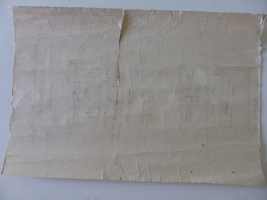
Document, Drawing of church of Christ Warrnambool, Mid 20th century
These are plans for proposed additions to the Church of Christ in Warrnambool. The date of the drawings and the maker of the plans are unknown. The additions do not appear to have been built. The Church of Christ in Warrnambool was founded in 1875 after a meeting at the Warrnambool Temperance Hall. The building in Spence Street Warrnambool was erected in 1884 at a cost of £1600 and officially opened in 1885. This church was sold and in 2000 the congregation moved to a new building at 186 Raglan Parade (called Gateway Church of Christ).These plans are of some interest as being part of the history of a Warrnambool church – the Church of Christ Warrnambool. These are two rough drawings on cream-coloured paper showing proposed additions to the Church of Christ in Warrnambool. The drawings are in pencil and include the front elevation plan and the first floor plan. The captions are in capital letters. Both pages have tattered edges and are torn across the middle and the pages are stained in places.‘Rough drawing suggested additions for Church of Christ Warrnambool’ ‘Suggested additions for Church of Christ Warrnambool’ church of christ warrnambool, gateway church of christ, history of warrnambool -
 Warrnambool and District Historical Society Inc.
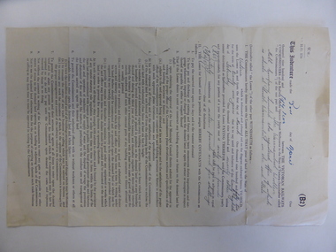
Document, Lease of Land by Victorian Railways to Warrnambool Woollen Mill Co Ltd, 1952
The Warrnambool Woollen Mill was established in 1910 in South Warrnambool by a local company, with the building erected on a site that formerly housed another woollen mill destroyed by fire in 1882. The Warrnambool Woollen Company operated successfully for many years with over 700 employees in the 1940s and a good national reputation for quality goods. It made blankets and other woollen goods and was the first company in Australia to manufacture electric blankets. In the 1960s the mill was sold to the Dunlop Company and for the next thirty years it was bought and sold several times, finally closing in 2000 after 90 years of operation. The woollen Mill was built on a site which was in easy access to the railway line which operated along the original tramway line from the town to the jetty. It is possible that this land would have been used for parking during the period of 1950's to 1970's which was a successful period of manufacturing and trade for the Woollen Mill. A link between an important infrastructure and one of Warrnambool's most important industries.Four page folded document cream in colour . Printed form with diagram of the land in question coloured in pink . Seals of both Victorian railways and Warrnambool Woollen mill are stamped beside signatories on page 3. Dated 30th April 1952. Signed R Naylor for the Warrnambool Woollen Mill and two unreadable signatures for Victorian Railways.warrnambool, warrnambool woollen mill, warrnambool railways, lease victorian railways and warrnambool woollen mill -
 Warrnambool and District Historical Society Inc.
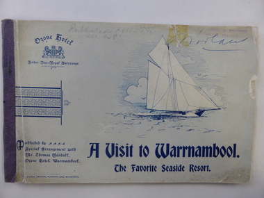
Book, The Ozone Hotel Warrnambool, Early 1900s
This booklet was produced for Thomas Randall, the proprietor of the Ozone Hotel, Warrnambool. The booklet has the front cover missing and the title of the booklet is actually ‘A Visit to Warrnambool’. It is a publicity booklet given out gratis to prospective clients of the hotel. The Ozone Hotel was originally called the Grand Ozone Coffee Palace and opened in 1890 as a temperance hotel, a splendid building with over 100 rooms. In December 1891 the Coffee Palace was granted a Colonial Wine Licence and in 1895 it was renamed the Ozone Hotel. Thomas Randall was the hotel keeper from 1894 to 1907. In 1920 the Ozone Hotel, after being closed for some time, was re-opened as the Hotel Mansions and a full liquor licence was obtained in 1923. In 1929 the building was burnt down and the present-day Hotel Warrnambool was built on the site. This booklet is of great significance as it documents the splendour of the Warrnambool Ozone Hotel when it was at its best. This building is regarded as the finest and most elegant building ever built in Warrnambool and this booklet contains the only photographs we have of the interior of a 19th century/early 20th century hotel in Warrnambool. This is a soft cover booklet publicizing the Ozone Hotel, Warrnambool, published for the proprietor Thomas Randall early in the 20th century. The front cover and several pages at the back are missing. The booklet contains advertisements, both local and Melbourne ones, black and white photographs of Warrnambool and district and of the interior and exterior of the Ozone Hotel, an article on the town of Warrnambool and extracts from the hotel’s Visitors’ Book. Most of the pages contain black and white ornamental motifs. One of the pages at the front of the booklet is torn in half. The booklet is bound with staples. On first page: Warrnambool & District Historical Society Stamp (smudged)grand ozone coffee palace/ozone hotel/hotel mansions, thomas randall, history of warrnambool -
 Warrnambool and District Historical Society Inc.
Booklet, A visit to Warrnambool, Early 20th century
This booklet was produced for Thomas Randall, the proprietor of the Ozone Hotel, Warrnambool, situated at the corner of Kepler and Koroit Streets. It was a publicity booklet given out gratis to prospective clients of the hotel. The Ozone Hotel was originally called the Grand Ozone Coffee Palace and opened in 1890 as a temperance hotel, a splendid building with over 100 rooms. In December 1891 the Coffee Palace was granted a Colonial Wine Licence and in 1895 it was re-named the Ozone Hotel. Thomas Randall was the proprietor from 1894 to 1907. In 1920 the Ozone Hotel, after being closed for some time, was re-opened as the Hotel Mansions and a full liquor licence was obtained in 1923. In 1929 the building was burnt down and the present- day Hotel Warrnambool was built on the site. This booklet is of great significance as it documents the splendor of the Warrnambool Ozone Hotel when it was at its best. This building is regarded as the finest and most elegant building ever built in Warrnambool and this booklet contains the only photographs we have of the interior of a 19th century/early 20th century hotel building in Warrnambool. This booklet is also of interest as it belonged to Henri Worland, the Town Clerk of Warrnambool from 1918 to 1949 and Warrnambool’s best-known historian. This is a soft cover booklet of 64 pages. The cover is blue-grey and has an image of a sailing ship, the logo of the Warrnambool Ozone Hotel and some ornamental scrolls. The printing on the front cover is blue. The back cover has two advertisements for Melbourne businesses. The booklet is stapled and bound with purple tape. The booklet contains black and white advertisements for Warrnambool and Melbourne businesses, an article on the town of Warrnambool and black and white photographs of Warrnambool and district and of the interior and exterior of the Ozone Hotel. Most of the pages contain some ornamental patterns. The front cover is a little ragged and torn. Signature of H.Worland on the front cover and on the first inside page. grand ozone coffee palace/ozone hotel/hotel mansions, history of warrnambool, thomas randall -
 Warrnambool and District Historical Society Inc.
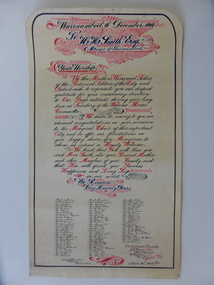
Document, Illuminated Address H. H. Smith esq
This illuminated address was given to H.H.Smith, the Warrnambool Mayor, for his work with soldiers returning to Warrnambool and district during and after World War One. On the same occasion Smith was also given an armchair by the mothers, sisters and wives of Warrnambool returning soldiers. Henry Huntingdon Smith (1857-1941) started his own bakery business in 1885, firstly near the corner of Fairy and Koroit Streets and later building his own shop at the corner of Lava and Fairy Streets (Monaghans Pharmacy today). Smith was one of the most admired men in Warrnambool in the first half of the 20th century. He was a Warrnambool Councillor from 1918 to 1937 (Mayor for two terms) and served continuously on the Warrnambool Hospital Committee for 39 years. He visited patients at the Hospital twice a week. He took a particular interest in the welfare of returning soldiers and it was said that there was not a returned man or woman whom Smith did not greet on his return to the district. Smith also was a tireless worker for the Methodist Church as an office bearer and a Sunday School teacher. Smith was also Vice President in 1937 of the first Warrnambool & District Historical Society. This document is of particular interest as it is a good example of the type of illuminated address produced during the early years of the 20th century. It also shows clearly the respect and love that Warrnambool people had for Henry Smith, a great volunteer worker in the community. This is a piece of cream-coloured parchment paper with a margin ruled in black ink and handwriting in blue and black ink surrounded by red ornamental scrolls and flourishes. The paper has an address to H.H.Smith and is followed by 74 names and the date (1920). The paper is inserted into a piece of red leather cloth. This has folded edges and an ornamental gold pattern around the front edges and a gold border around the back edges. There are two holes at the top of the folder and these have metal surrounds. The backing folder is rounded at the top edges. ‘Warrnambool, 6th December 1919. To H.H. Smith Esq., Mayor of Warrnambool – We, the Mothers, Wives and Sisters of the Returned Soldiers of this City and District wish to express to you our deepest gratitude for your unswerving devotion to Our Boys interests during your long term as Secretary of the Welcome Home Committee’ (etc etc)henry huntingdon smith, world war one, history of warrnambool