Showing 3407 items
matching bridge road
-
 Warrnambool and District Historical Society Inc.
Ledger, Letters on Suspension Bridges, 1890s
This book contains information on the building of suspension bridges and dates from the 1890s. It belonged to John William Crawley Junior, an engineer, surveyor and architect in private practice in Warrnambool and also the engineer for the Shire of Warrnambool from 1895 to 1935. The information in the book comes in the form of lectures on suspension bridge making and these were sent to John Crawley by his tutor or coach, Arnold Lilley (Lilly). Arnold Lilley was an Oxford mathematician working in Victoria and it is said that he coached or trained 95% of the municipal surveyors in Victoria in the 1890s. John Crawley has obviously had this material bound into a book and it was passed on to his son, Rolf, who was the engineer for the Shire of Warrnambool from 1935 to 1968. It then came into the possession of Michael Hand who took over the private surveying business of Rolf Crawley in Warrnambool. The Warrnambool and District Historical Society acquired the book, along with several Crawley ledgers and letter books, from the estate of Michael Hand. This book is of interest as it contains lectures and other material on the building of suspension bridges and belonged to John William Crawley Junior, an engineer for the Shire of Warrnambool for 40 years. It also is a memento of the work of Arnold Lilley who produced the material on suspension bridges and coached John Crawley in his surveying studies.This is a hard cover book with a purple cover. The cover is slightly faded. The book contains handwritten material regarding the building of suspension bridges and includes sketches, lectures on suspension bridges and pages with postage stamps on them. There are three loose pages. ‘’Letters on Suspension Bridges Arnold Lilly Esq. Coach J Wm. Crawley Pupil’john william crawley junior, warrnambool, rolf crawley, warrnambool, shire of warrnambool, arnold lilley, teacher of surveying. -
 Warrnambool and District Historical Society Inc.
Documents, 6 Postcards: from Bert/Robert Stanley Harper to Gladys Holmes, pre 7th Jan 1917
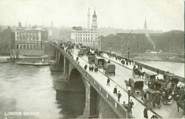
Correspondence from Bert/Robert Stanley Harper on overseas service to Gladys Holmes, Byaduk. Robert Stanley Harper, enlisted 19th April 1915, served as 1692 as Pte RS Harper with 22nd Infantry Battalion, Sailed on "HMAT 64 Demosthenes' Fought at Gallipoli, Pozieres, Bullecourt and returned to Australia in 1919.Original documents written by Robert S Harper to Gladys Holmes, Byaduk during WW1. 001802.1: London Bridge, London, 001802.2: St James Palace, London, 29th August 001802.3: Embroidered insert, Good Wishes 001802.4: Mt Lavinia, Colombo 001802.5: Gladys and pansy 001802.6: Marseilles001802.1: Weymouth, 8th Jan 1917 001802.2: London, 29th August 001802.3: In France 001802.4: Colombo 001802.5: 001802.6gladys holmes, postcard, ww1, bert/robert harper, byaduk, tuck's post cards, gallipoli,pozieres, bullecourt -
 Warrnambool and District Historical Society Inc.
Label, Rosebrook Cheese and Butter Factory, Early 20th century
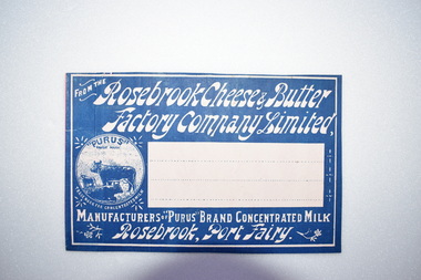
The Rosebrook Cheese and Butter Factory was opened in November 1888 by Messrs Lydiard &T F Rutledge & was a cooperative factory managed by Mr. Goldie. It operated out of the former Rosebrook Flour Mill which was built on the banks of the Moyne River near the Rosebrook bridge in the late 1840s. In 1896 the factory commenced the production of the condensation of milk. The company closed in 1911. The building and machinery were sold in 1917. Rosebrook is situated about 20 kilometres from Warrnambool on the Princes Highway. This label is of some local significance as the Rosebrook Cheese and Butter factory operated for 30 years Rectangular dark blue and white label featuring text and a trade mark. The latter is circular with three cows pictured. There are decorations of flowers and leaves. The central area of the label is white with three lines. The label is adhered to a piece of pink card.FROM THE Rosebrook Cheese & Butter Factory Company Limited, MANUFACTURERS OF "PURUS BRAND CONCENTRATED MILK Rosebrook, Port Fairy. "PURUS" TRADE MARK FOR CONCENTRATED MILKrosebrook, cheese and butter, concentrated milk, lydiard, rosebrook butter factory -
 Port of Echuca
A black and white postcard, 1906. or. 1916
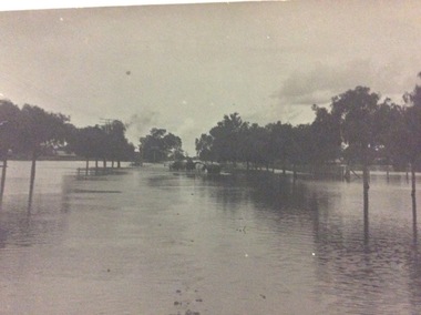
The postcard is significant because it shows the extent of the flood in the early 20th Century. The bridge crosses the Southern Cross channel which had been built as part of the Murray Darling irrigation system. There is a vehicle on the bridge either being towed by bullocks or horses. Floodwaters cover the whole view.The postcard is significant because it shows the extent of the flood in the early 20th Century. The bridge crosses the Southern Cross channel which had been built as part of the Murray Darling irrigation system. It is also near the water filtration plant which filters the town's water supply. There is a vehicle on the bridge either being towed by bullocks or horses. Floodwaters cover the whole view.A black and white postcard showing Goulburn Road, Echuca East, in either the 1906, or 1916 floods.Printed on the back are the words; W. Grimwood Echuca. POST CARD. Correspondence Address Only Kodak Australia. Hand written on the back are the words 1906 or 1916? Southern Cross bridge near filtration plant. Goulburn Road, Echuca East.floods, goulburn road, echuca east, pullicino, j, postcard, southern cross channel, water filtration plant -
 Port of Echuca
Photograph, Original photo c.1920
The iron bridge was completed in 1878 and was used by the Deniliquin and Moama Railway company for goods trains only - it was another year before passengers were included in the transport service. On 4 March 1879 citizens of Echuca and Moama stormed the bridge, opened the gates and declared it open for their use.At the turn of the century the railway line carried produce from southern New South Wales & the Riverina to Melbourne, with goods trains being a very important mode to transport. When the bridge was being constructed, six workmen were killed and another maimed when a pile on the Moama bank collapsed. After the storming of the bridge by local people in March 1879 it was declared open for use of local residents traveling between the towns of Echuca and Moama. The bridge was shared by rail, road and pedestrian traffic.An image of the iron bridge at Echuca, taken looking East from Victoria bank.Verso: "Iron bridge"murray river bridge , echuca, murray bridge, echuca, iron bridge, echuca -
 Port of Echuca
Photograph, Approx. 1970's
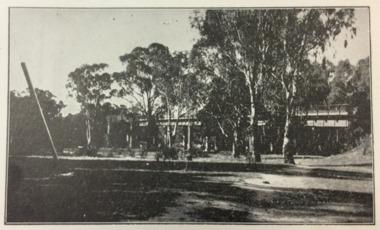
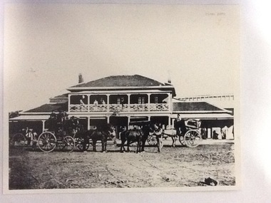
The Bridge Hotel was built by Henry Hopwood to house visitors to the town crossing the Murray River on his punt , which was situated just below the Bridge Hotel on the Murray River. The accommodation was spacious and grand! In the right back corner of the photograph, the 'lantern' roof of the St George's Hall can be seen. The street is level with the front entrance to the Hotel, which is very different to what it is today.The photograph shows hotel activities and accommodation in the late 19th Century. The Bridge Hotel was a very busy place as can be seen with women on the balcony, a stage coach full of people, laden carts and buggies.The Bridge Hotel Echuca - photo taken looking south towards front of building. Four people can be seen on the balcony and several gathered under the verandah. In the foreground are several horse-drawn carriages. The road in front of the hotel is unmade and very wide, with the roof of St.George's Hall seen over the right (western) wing of the hotel. Verso: Bridge Hotel, 1860s? St. George's Hall in background.bridge hotel, henry hopwood, lantern roof, st.george's hall, 1870s -
 Warrnambool and District Historical Society Inc.
Domestic object, Drink Coasters (4)
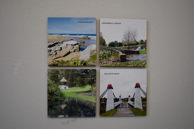
These coasters depict scenes from Warrnambool – the Botanic Gardens, The Hopkins River mouth and the Wollaston Bridge. All are areas of historical and tourist interest. The coaster were produced to raise funds for Peters Project in Warrnambool, a charity organization dedicated to bringing improved cancer care services to Warrnambool. The organization was founded in 2008 by Vicki Jellie in memory of her husband Peter who died of cancer. The major aim of the organization was realized in 2016 when the South West Regional Cancer Care Centre was opened in a new building in Ryot Street and services to assist cancer patients in Warrnambool continue to be extended. These coasters are of some interest as examples of fund-raising material produced by the Peters Project committee to assist with the campaign to bring improved cancer care services to Warrnambool..1 .2.3.4 A wooden drink coaster with a felt base and a colour photograph pasted on the top section.1 Warrnambool Gardens .2 Hopkins River Mouth .3 Wollaston Bridge .4 Warrnambool Gardenspeter’s project, warrnambool, vicki jellie, warrnambool souvenirs -
 Eltham District Historical Society Inc
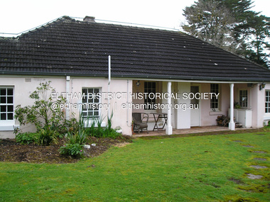
Photograph, Fay Bridge, Rosehill Homestead, EDHS Heritage Excursion, 6 July 2019
July Excursion July 6, 2019 - Exploring Lower Plenty The predominant feature of this walk in the Bonds Road area, Lower Plenty is the large number of magnificent old River Red Gums that line the route. These trees are of the spreading woodland form of this species indicating that they must have been originally growing in a reasonably open setting. The walk also includes parts of the historic Cleveland Estate and the homestead “Rosehill” established by pioneer farmer Henry Stooke. This area was the site of the first recorded European settlement in what was to become the Shire of Eltham when the Willis brothers arrived in the late 1830s. From the southern part of Cleveland Avenue there are extensive views across and along the Yarra Valley. An article on the history of this area was contained in Newsletter edition 201, November 2011. The walk will start at the at the corner of Bonds and Stawell Roads, Lower Plenty - EDHS Newsletter No. 246 June 2019fay bridge collection, 2019-07-06, blackburn bricks, eltham district historical society, heritage excursion, rosehill homestead, lower plenty -
 Eltham District Historical Society Inc
Photograph, Fay Bridge, United Service Station, Main Road, Eltham, 26 August 2019
fay bridge collection, 2019-08-26, cockatoos, diamond street, eltham, luck street, main road, united service station -
 Eltham District Historical Society Inc
Photograph, Fay Bridge, United Service Station, Main Road, Eltham, 26 August 2019
fay bridge collection, 2019-08-26, hurstbridge wattle festival, k-153, k-class steam locomotive (vr newport workshops), steam locomotive, steamrail victoria -
 Eltham District Historical Society Inc
Photograph, Fay Bridge, EDHS Heritage Excursion, Culla Hill, Sweeneys Lane, Eltham, 7 September 2019
September Excursion - Culla Hill Walk Pioneer Eltham farmer Thomas Sweeney (1803 - 1867) named his house, “Culla Hill” after the area in Ireland that he came from. His house, now called “Sweeneys”, remains on a ridge line overlooking the Yarra River. It is recorded that Thomas Sweeney did well out of carting potatoes and other supplies to the various gold fields such as Bendigo, McIvor (Heathcote), Mount Alexander and Beechworth. Culla Hill is now the name of the road providing access to subdivided lots of the former Sweeney property. The Culla Hill walk will start at the corner of Kent Hughes and Lavender Park Roads, Eltham (Melway ref. 22 A9) at 2.00pm on Saturday 7th September. - EDHS Newsletter No. 247 August 20192019-09-07, activities, culla hill, eltham, eltham district historical society, fay bridge collection, heritage excursion, sweeneys lane -
 Eltham District Historical Society Inc
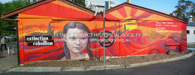
Photograph, Fay Bridge, Extinction Rebellion protest mural, Platform 3095, 965 Main Road, Eltham, 29 January 2020
Extinction Rebellion protest mural painted on the western wall of Platform 3095 cafe facing the railway station Prior to September 2016 a grouping of five trees were planted in the small garden bed on the western end of the cafe in two groups either side of the traffic sign which at that stage was the taller By October 2017 the five trees had doubled in height to about 1m above the roof line By April 2018 the trees were all about 2m above the roof line By August 2019 all five trees had been cut down and the wall was a mixture of paint patches from ongoing graffitti attacks By January 2020 the wall had been adorned with this mural which appears to have discouraged ongoing graffitti attacks but its message is tinged with irony that five healthy young trees were removed fay bridge collection, 2020-01-29, eltham, platform 3095, extinction rebellion -
 Eltham District Historical Society Inc
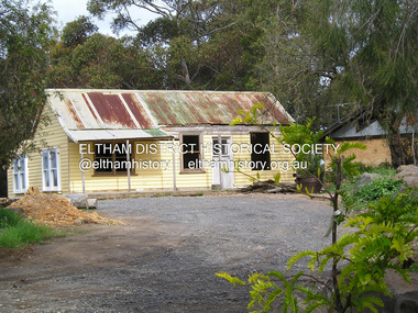
Photograph, Fay Bridge, Former cottage of Tom Ellis, 230 Kangaroo Ground-St Andrews Road, Kangaroo Ground, 13 November 2021
Tom Ellis was the great grandson of pioneer William Ellisfay bridge collection, 2021-11-13, kangaroo ground, kangaroo ground-st andrews road, tom ellis house -
 Eltham District Historical Society Inc
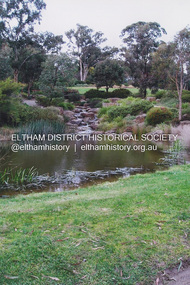
Photograph, Fay Bridge, Lake, Eltham Cemetery, 40 Mount Pleasant Road, Eltham, c.2009
Robert Boyle Landscape Design created the original design and construction of the lake in 1993. They are renowned local landscape designers and have carried out numerous projects at the Cemetery, including the major upgrades to the lakeside design in 2020. Title Lakeside Maintenance and Improvement Works Url https://www.elthamcemetery.com/item/25-lakeside-maintenance-and-improvement-works Description Improvement works to the lake and surrounding area July to October 2020.fay bridge collection, 2009, eltham, eltham cemetery, lake, mount pleasant road -
 Eltham District Historical Society Inc
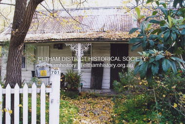
Photograph, Fay Bridge, Former Jarrold Cottage and Bootmaker's Shop, 701 Main Road, Eltham, n.d
... Road. Fay Bridge Collection Bootmaker's Shop Eltham Jarrold ...Situated originally on the corner of the Dalton Street road reserve west of Main Road (now present-day Wingrove Park Trail), the former Jarrold Cottage (White Cloud) was purchased by Lena Skipper following Thekla Jarrold's death in 1943. It was built by William Jarrold in the early 1850s and was here that he married Hannah Coleman in 1856. The Bootmaker's shop was built by Thekla Jarrold in 1930 for use by her friend, John Clark, a local photographer who had boarded with the Jarrold family since about 1910. In 1930 he changed profession to a bootmaker and leather worker. The shop is one of only three remaining early 20th century shops in what was Little Eltham, the others being present-day San Antionio Barber Shop at 820 Main Road and Cafe Zen Den at 736 Main Road.fay bridge collection, bootmaker's shop, eltham, jarrold cottage, main road, shops, white cloud cottage, wingrove park trail -
 Eltham District Historical Society Inc
Photograph, Fay Bridge, Old footbridge, 195 Laughing Waters Road, Eltham, n.d
This old footbidge is situated close to the shack that Gordon Ford built on the Yarra at Laughing Waters Road. Bernie Bragg also used to live there for a period of time. Gordon Ford and photographer Sue Winslow were married in 1965. They set up home in an old log cabin on the property Gordon had purchased in 1954 on Laughing Waters Road. Situated between the Yarra River and Overbank Road, Gordon had built a small mud-brick shack on the river and a pontoon. Over the decades the shack has been locally referred to as “the love shack”, the “rooting shack” or simply “Gordon’s shack”. Gordon and Sue commissioned local builder Graeme Rose to do a wattle and daub renovation and extension to the old log cabin on the north side of Laughing Waters Road. The work had only just been completed in 1965 when a bushfire swept through the area and destroyed the cabin. Gordon and Sue relocated to his property, Fulling, in Pitt Street, Eltham. In 1970 work started on a new house at the Laughing Waters property. Originally known as the Banana House, it is now known as Boomerang. Designed by Alistair Knox, the mud-brick house includes iron window grilles made by Matcham Skipper that puncture the curved mud walls. The grilles were made from ‘off-pressings’ from the Sidchrome tool works in Heidelberg. Gordon, Sue and family moved into the house in 1972. Their marriage fell apart and Sue moved to Sydney with the children around the same time Gordon commenced building Birrarung just below Boomerang on the Laughing Waters Road block. After the Fords moved out, Boomerang it was rented out to various share households of students, musicians, artists and environmentalists for twenty-four years. Gordon Ford sold Birrarung and Boomerang to Melbourne Water in 1999. The Laughing Waters Artist in Residence Program was developed as a partnership between Parks Victoria and Nillumbik Shire Council. Boomerang was deemed unfit for habitation so was used as a day studio only. By 2001 Boomerang was in a poor state of repair and by 2002 the last artist in residence was to use the house as a studio. Nillumbik Shire Council had been granted funds from the Melbourne Community Fund to restore both Boomerang and Birrarung but it was apparent in early 2003 that the funds would be insufficient to restore both houses. Boomerang was infested with termites which presented a risk to any occupants and so the decision was made to close Boomerang and concentrate funding on Birrarung. Boomerang was fenced off for safety and to prevent intrusion and remains ‘caged’ today (2023). However, it is readily apparent the property has been occupied by squatters over the years. By 2023 it was clear that the squatters had abandoned the property and sections of the roof structure have given away in some areas and collapsed internally. For a more in-depth description and history of the property and that of Gordon and Sue Ford, see Jane Woollard's book, "Laughing Waters Road; Art, Landscape & Memory in Eltham" published 2016.fay bridge collection, bernie's hut, birrarung, footbridge, gordon ford, gordon's shack, laughing waters road, love shack, yarra river -
 Eltham District Historical Society Inc
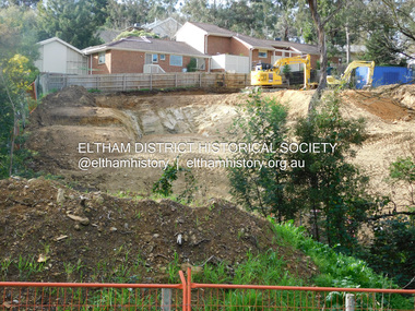
Photograph, Daryl Morrow, Redevelopment of former site of Hassall's Roadside Gallery, Main Road, Eltham, 10 July 2023
This historic site of Australia’s first open-air gallery is being redeveloped in 2023 for multi-housing fronting the Research Creek. In 1955, Ian and Joan Hassall moved to Eltham. They took a property on the corner of Zig Zag Road and Main Road, Eltham, north of the township (later known as 1215 Main Road). In July 1962, they opened their open-air gallery. Hassall’s Roadside Galley, “…cradled in the fold of hills to the north of Eltham” inspired by Ian’s own experience of exhibitions along the Embankment in London. The property included remnants of a stone quarry, paintings were hung on screens and removed at night. Various pedestals, that looked like giant mushrooms displayed sculpture, pottery, and jewellery. It had a small natural amphitheatre at the foot of a little sandstone cliff that fall away to the bed of a stream. To enter the gallery, a visitor crossed a small freestone bridge of oriental design, built by Hassall from local stone. The bridge spanned the stream flowing beneath great willow trees. Near the entrance wooden figures were displayed formed from pieces of local wood, said to speak to Ian Hassall’s sense of fun. Hassall’s Gallery was the first gallery of its kind in Australia. Ian became a full-time artist and when it first opened, he exhibited paintings he had made while touring the outback with writer and fellow Eltham resident Alan Marshall. He also exhibited other Australian artists over time including locals Lindsay Edward and Peter Glass.daryl morrow collection, eltham heights luxury living, hassalls roadside gallery, housing development, real estate development, research creek, 2023-07-10 -
 Eltham District Historical Society Inc
Photograph, Daryl Morrow, Redevelopment of former site of Hassall's Roadside Gallery, Main Road, Eltham, 13 July 2023
This historic site of Australia’s first open-air gallery is being redeveloped in 2023 for multi-housing fronting the Research Creek. In 1955, Ian and Joan Hassall moved to Eltham. They took a property on the corner of Zig Zag Road and Main Road, Eltham, north of the township (later known as 1215 Main Road). In July 1962, they opened their open-air gallery. Hassall’s Roadside Galley, “…cradled in the fold of hills to the north of Eltham” inspired by Ian’s own experience of exhibitions along the Embankment in London. The property included remnants of a stone quarry, paintings were hung on screens and removed at night. Various pedestals, that looked like giant mushrooms displayed sculpture, pottery, and jewellery. It had a small natural amphitheatre at the foot of a little sandstone cliff that fall away to the bed of a stream. To enter the gallery, a visitor crossed a small freestone bridge of oriental design, built by Hassall from local stone. The bridge spanned the stream flowing beneath great willow trees. Near the entrance wooden figures were displayed formed from pieces of local wood, said to speak to Ian Hassall’s sense of fun. Hassall’s Gallery was the first gallery of its kind in Australia. Ian became a full-time artist and when it first opened, he exhibited paintings he had made while touring the outback with writer and fellow Eltham resident Alan Marshall. He also exhibited other Australian artists over time including locals Lindsay Edward and Peter Glass.daryl morrow collection, eltham heights luxury living, hassalls roadside gallery, housing development, real estate development, research creek, 2023-07-13 -
 Eltham District Historical Society Inc
Photograph, Liz Pidgeon, EDHS Heritage Walk: Shillinglaw Farm, Eltham, 2 September 2023
On Saturday September 2, 2023, Russell Yeoman led a group of 22 society members and interested others on a walk following trhe bounadries of the original Shillingalw farm. Commencing at the corner of Panther Place and Library Place, we proceeded up to Shillinglaw Cafe then the Shillinglaw trees at the former Eltham Shire Office site then along Main Road to the fire station then throughh St Laurence Lane and uinder the railway line , along Diamond Street then return via the Diamond Creek trail behind Andrew Park. The actual farm boundary went past the creek and further up the hill. The original farm comprised lot 90 of Holloway’s 1851 subdivision of Little Eltham. Its area was 30 acres lying east of the Diamond Creek and north of Henry Street. A number of stops were made to look at maps and early photos illustrating the gradual reduction of the farm area and the early history of the railway and other community uses, that occupied parts of the site.2023-09-02, activities, eltham, eltham district historical society, heritage excursion, shillinglaw farm, 895 main road, amplifon, andrew park, andrew pocket park, arthur street, bar de tapas, barber shop, barry plant estate agent, blockbuster, bus depot, car park, carparks, central park, cleaver & co hair, commonwealth bank, crust pizza, divine bridal, dr ash constance, dudley street, eltham book shop, eltham convenience store, eltham fire station, eltham library, eltham newsagency, eltham optical, eltham railway station, eltham shops, fay bridge, fire bell, flagpole, flight centre, grill'd, information sign, iso chook, jellis craig estate agent, judge book village, kebab nation, kx pilates, la zanyas, liquorland, little drop of poison, lorraine jones & associates solicitors, luck street, machan indian restaurant, main road, mecho en mexico, missing gorilla, morrison kleeman real estate, pavilion menswear, platform 3095, playtherapy melbourne, pryor street, ray white real estate, restaurants, sage bulk whole foods, shillinglaw trees, sign, snap fitness, southern cross medical imaging, specsavers, st laurence lane, st vincents care service, thompson's pharmacy, todaro, united service station, vyve body & skin, welcome to eltham town, westpac bank, yang's kitchen, youth road -
 Eltham District Historical Society Inc
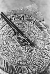
Photograph (Item) - Negative, Samantha Robertson, Eltham Community Photographic Survey Entry, 1988
Samantha Robertson 1988 Entrant No. 1 Ref: Series 34 Items 1, 2, 42-45 The images in this record were not selected for inclusion. SHIRE OF ELTHAM COMMUNITY PHOTOGRAPHIC SURVEY Photography is an artform which many of us practice, sometimes purely for artistic pursuit, sometimes to record the people and events in our lives. In 1988, as part of a local Bicentennial project, the Shire of Eltham conducted the Eltham Community Photographic Survey. Up to 100 entries were to be selected by a panel of photographers for entry into the Eltham Photographic Survey Exhibition. Entries had to be submitted by May 13, 1988. Entrants whose images were selected for the exhibition were contacted and requested to further submit an entry form providing entrant’s name, area of residence, age, and proposed captions. These details were then used to produce labels for the exhibition mounts. Where negatives had not been supplied, these were requested to support the display of printed enlargements mounted on 10” x 8” cardboard. The mounted prints were made available post exhibition for sale at $8.50 each for colour prints and $7.00 for B&W prints. Residents in the Shire were invited to collect a free roll of film and take a photograph of what they either liked or did not like about the area. A total of 160 entrants submitted multiple entries for the exhibition. Of those selected for exhibition, entrants ranged in age from 9 to 70 years. All custom colour and black and white printing for the exhibition was completed by Wattle Studios of Eltham. The Eltham Photographic Survey was jointly auspiced by the Shire of Eltham and Wattle Studios, of 953 Main Road, Eltham. The project was greatly assisted by: • David McRitchie, Media Studies Lecturer Victoria College, Rusden Campus. • Ian and Annette Toohill of Wattle Studios • Tracy Naughton, Eltham Community Arts Officer • Neville Emerson Pty. Ltd. • Superior Press, Eltham • Kodak Australasia Pty. Ltd. • Agfa Gevaert Ltd. • Townsend Colourtech Pty. Ltd. • The Australian Bicentennial Authority • Eleanor Bowers, Secretary, Eltham Arts Council The exhibition was placed on display in the Woolworths Arcade, Eltham between Monday June 6th and Saturday June 11, 1988. It was also intended to hold the exhibition at a venue in the Shire’s North Riding from Monday, June 20 to Friday June 24. It was then displayed at the Were Street Theatre, Montmorency from Friday, June 24 to Thursday, July 7. Series 34: Eltham Community Photographic Survey 1988 - Prints & Documentation Series consists of 117 photographs of Shire scenes taken by members of the community. Items I - 41 are larger photographs mounted on card, which were exhibited. Items 42 - 117 are unmounted copies, alternative takes and other entries. Corresponding negatives contained in Series 35: Eltham Community Photographic Survey 1988 – Negatives which consists of 267 colour and B&W negatives and one colour slide of Shire scenes taken by members of the community. The negatives are arranged by the entrant number of the photographer. The Eltham Community Photographic Survey collection is significant to the local community as it was curated by the local community - ordinary people of all ages - representing what they liked and did not like in the area where they lived. It represents an unfiltered representation of the Shire of Eltham as it was in 1988. It also represents one of many projects as part of the national programme of events and celebrations to commemorate the bicentenary. It is a time capsule of life in the 1980s of this urban and rural municipality in Melbourne's north. shire of eltham archives, bicentennial project, eltham, eltham community photographic survey, samantha robertson, series 35, film - ilford xp1 400, scan - 35mm negative, sundial, eltham trestle bridge, central park, panther place, graffiti, eltham senior citizens centre, eltham shire office, eucalyptus tree, main road, sign, arthur street, commercial place, eltham village, safeway carpark -
 Eltham District Historical Society Inc
Document - Folder, Eltham Banner Project, 1986
Newspaper articles about the As We Are Eltham Banner Project undertaken within the Shire of Eltham 1. Eltham banner to celebrate environment, Diamond Valley News, Tuesday, September 16, 1986, p16 2. Group paints for peace, Diamond Valley News, Tuesday, September 30, 1986, p2 3. Banners show people of Eltham as they are, Diamond Valley News, Tuesday, October 14, 1986, pp12-13 4. Banners fly high at lastt, Diamond Valley News, Tuesday, October 21, 1986, p17 Also various advertisements from businesses within the shire Newspaper clippingsas we are, banner project, eltham banners, meruka house, sarah houseman, advertising, eagle screens & blinds, 1986, alistair knox park, bob manuell, don brown, dooncal air coinditioning and central heating, eltham festival, eltham outdoor art show, eltham peace banner, eltham town park, grand parade, pauline therese toner, peter wilson, research shops, river of life banner, shire of eltham acquisitive award, valley carpets, 16 sherbourne road briar hill, 22 were street montmorency, 1177-1181 main road eltham, barry reading goumet butchers, eltham hardware & plumbing supplies pty ltd, hutchinsons garden supplies, 38 bridge street eltham, artists, costless clearance centre, cr bob manuell, jud duigan, margaret cherry, tracey naughton, woolworths arcade, anthea morrison, beyond the end of the line, diamond valley musical society, eltham college, eltham community festival, eltham high school, eltham service club, geraldine veerman, ian robertson, 19 were street montmorency, arnold thomas, arnolds recycling centre, kevin mcnamara, luck street eltham, mcewans, montmorency hardware, peel street eltham, tim payze, 1022 main road eltham, as we are banner exhibition, jud degan, marg cherry, the cut ahead, arthur street, eltham mall, flexiteller, national australia bank -
 Eltham District Historical Society Inc
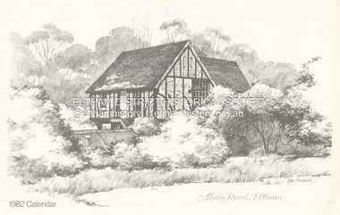
Calendar, Bill Caldwell, Sketch (reprint): Main Road, Eltham, Bill Caldwell n.d, c.1981
One of a series of sketches commissioned by Neville Emerson of Neville Emerson Real Estate, originally for use as christmas cards. EDHS does not hold a Christmas card of this image which was also used on the Wiregrass Gallery calendar for 1982. Whilst titled Main Road, Eltham, the house featured is that of Matcham Skipper which is raised on stilits due to the propensity of the Diamond Creek to flood. The actual address for the house is Dalton Street.Illustration from 1982 calendarart, artist, bill caldwell, fay bridge collection, neville emerson real estate, sketches, wiregrass gallery calendar, matcham skipper, dalton street -
 Eltham District Historical Society Inc
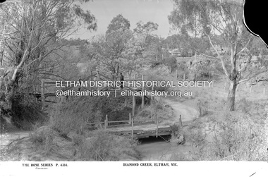
Negative - Photograph, The Rose Stereograph Company, Diamond Creek, Eltham, Vic, c.1919
Shows two bridge crossings over the Diamond Creek in Diamond Street, Eltham. The upper pedestrian crossing provided continual access for foot traffic during times of flood. The railway came to Eltham in 1901, the Eltham Railway Station is visible in the distance as well as a wooden bodied Tait (Red Rattler) First Class train carriage. The Tait train was first introduced in 1910 as a steam locomotive hauled carriage and in 1919 electric motor carriages were introduced however the line to Heidelberg was not electrified till 1921 and to Eltham in April 1923. The Railway General Store on Main Road is visible beyond the station and was built by Luther Haley in 1902. It was the first shop in the present day shopping centre. It was later known as lloyd's stopre (1917-1920) followed by a succession of six other owners until purchased by Eric Staff in 1939. This glass plate negative was used to manufacture postcards (1:1 printing) for commercial sale by the Rose Sterograph Company and its subsidiaries. George Rose founded the Rose Stereograph Company in 1880 and was joined by Herbert (Bert) Cutts in the early 20th Century. The pair formed a lifetime working partnership and strong personal friendship. Assisted by George’s two sons, Herbert George and Walter, and later by Neil Cutts, the Rose Stereograph Company continued its operations for more than 140 years. The company was initially built on stereographs, but as cinema took over and stereographs fell out of fashion, the Rose Stereograph Company developed Australia’s first commercially viable photographic postcard business. Specialising in postcards of iconic historical moments and significant landmarks, The Rose Stereograph Company became a staple of the Australian travel industry.This remarkable collection of glass plate negatives, transparencies, and postcards – arguably Australia’s most significant photography collection outside of public hands – has been passed down through the generations, surviving war, relocation, and the harsh Victorian climate. The historic Rose Stereograph collection is the culmination of George Rose’s dream of capturing and preserving precious moments in time and remains the legacy of the Rose and Cutts families. It is with great sadness that the Cutts family says goodbye to a collection that spans five generations and 140 years. The Cutts family understands that for these historically important pieces to rest with one family is to deny others the pleasure of their custodianship.Glass Plate Negative Size: 9 x 13.9 cmDiamond Creek, Eltham, Vic., The Rose Series P. 4314, Copyrighteltham, postcard, travel, rose stereograph company, glass plate negative, rose series postcard, tait train, eltham railway station, railway store, staffs general store, diamond creek, diamond street bridge, lloyd's general store, railway station, peter and elizabeth pidgeon collection -
 Eltham District Historical Society Inc
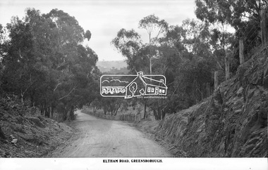
Photograph, The Rose Stereograph Company, Eltham Road. Greensborough, c.1936
... Believed to be looking east along Eltham Road towards... melbourne Believed to be looking east along Eltham Road towards ...Believed to be looking east along Eltham Road towards Eltham from around the top of the hill near the present day Andrew Yandell Habitat Reserve. Eltham Road, Greensborough followed what is now St Helena Road from Main Road Greensborough running into Karingal Drive and Sherbourne Road finishing at Bridge Street, Eltham. It was renamed sometime between 1968 and 1970. This glass plate negative was used to manufacture postcards (1:1 printing) for commercial sale by the Rose Sterograph Company and its subsidiaries. George Rose founded the Rose Stereograph Company in 1880 and was joined by Herbert (Bert) Cutts in the early 20th Century. The pair formed a lifetime working partnership and strong personal friendship. Assisted by George’s two sons, Herbert George and Walter, and later by Neil Cutts, the Rose Stereograph Company continued its operations for more than 140 years. The company was initially built on stereographs, but as cinema took over and stereographs fell out of fashion, the Rose Stereograph Company developed Australia’s first commercially viable photographic postcard business. Specialising in postcards of iconic historical moments and significant landmarks, The Rose Stereograph Company became a staple of the Australian travel industry.This remarkable collection of glass plate negatives, transparencies, and postcards – arguably Australia’s most significant photography collection outside of public hands – has been passed down through the generations, surviving war, relocation, and the harsh Victorian climate. The historic Rose Stereograph collection is the culmination of George Rose’s dream of capturing and preserving precious moments in time and remains the legacy of the Rose and Cutts families. It is with great sadness that the Cutts family says goodbye to a collection that spans five generations and 140 years. The Cutts family understands that for these historically important pieces to rest with one family is to deny others the pleasure of their custodianship.Glass Plate Negative Size: 9 x 13.9 cmEltham Road, Greensboroughpostcard, travel, rose stereograph company, glass plate negative, greensborough, cutting, eltham road, karingal drive, st helena road, peter and elizabeth pidgeon collection -
 Eltham District Historical Society Inc
Negative - Photograph, Harry Gilham, Grave of Richard George, Emily Ann (nee Davis) and Edith Jane Kaylock, Eltham Cemetery, Victoria, Sep 2009
In his early adult life, Richard Kaylock worked as a whaler (visiting California and New Zealand) and later as a drover on a large cattle station in New South Wales. In 1848 he came to Melbourne, working as a slaughterman, then settled in Eltham in 1854, his occupation thereafter being variously recorded as butcher or orchardist. He also had some experiences at Ballarat during the Eureka Rebellion. He died in 1910 at the age of 84. His obituary described him as a "striking personality" who was "brusque to a fault" and "strictly upright, expecting others to be the same". It seems from his will that he was illiterate. He is buried in Eltham Cemetery with his wife Emily. His property was in Wellington Street (now Brougham Street) and apparently extended across the Diamond Creek. The land on the western side of the creek was farmed, the house being on the eastern side. For many years the Brougham Street bridge was generally known as "Kaylock's Bridge". It formed part of the original coach road to Eltham and in 1922 was described as an "old rustic bridge". Its low level and insubstantial construction made it susceptible to flood damage, necessitating frequent closures until repairs could be carried out. The original bridge was demolished in 1923 and replaced by a "new up-to-date" one. When a lack of finances delayed repairs to the Bridge Street bridge in 1931, traffic had to detour via Brougham Street for some time. Local residents feared that the Bridge Street bridge might never reopen. In Loving Memory Of Our Dear Father & Mother R.G. and E.A. Kaylock Also E.J. Kaylock Died 21st Jan. 1927 The Eternal God Is My PledgeRoll of 35mm colour negative film, 6 stripsKodak GC 400-9eltham cemetery, gravestones, edith jane kaylock, emily ann kaylock (nee davis), richard george kaylock, brougham street bridge, kaylocks bridge -
 Eltham District Historical Society Inc
Negative - Photograph, Harry Gilham, Grave of Alfred and Margaret Armstrong, Eltham Cemetery, Victoria, Sep 2009
Alfred Patrick Armstrong was born in England in 1825 and was employed under the renowned Isambard Kingdom Brunel as a civil engineer during the construction of the Great Western Railway and the South Wales Railway. He came to Melbourne in 1852 and purchased property in Eltham. He became a mining surveyor and was Inspector of Mines and the Mining Registrar for the St Andrews Division of the Castlemaine Mining District. In 1855, he chaired a meeting calling for a bridge to be erected across the Yarra River between Eltham and Temple Stow. He was registered as an innkeeper in 1858, was a recognised collector of the £110 raised for the building of the first building of State School No. 209 (Eltham Primary) and was a Trustee for the Church of England site on the Eltham Cemetery Trust in 1860. He was elected to the Eltham District Road Board (forerunner of Eltham Shire Council) from 1867 to 1871 and then served as an Eltham Shire Councillor from 1871 to 1878 (including Shire President in 1873). Margaret Armstrong to whom he was married in 1854 at St Pauls Church, Melbourne, died on the 27th March 1887. Alfred died in 1893, having been in ill health for some time, and is buried in Eltham Cemetery with his wife Margaret. The monument features a tall pillar capped with a draped urn: a symbol of death. In Loving Memory of Alfred Armstrong Died May 27tth 1893 Aged 68 years Also of his wife Margaret Died March 27th 1887 Aged 63 years This burial site is of special interest as the monument has the tallest pillar-a vase-a draped cloth top (unfulfilled life) and additional panels of names around the sides and the base, which include: Ada Gertrude Armstrong, beloved daughter of Alfred & Margaret Armstrong, died May 30th 1878, aged 21 years Mary Armstrong, beloved mother to Alfred Armstrong, died April 10th, 1886 aged 82 years Arthur Vivian Harrison, died 4th Nov. 1899, aged 8 years Arthur Reynolds Stockwood Armstrong, son of Alfred Armstrong, died 4th Nov. 1908, aged 43 years Laura Augusta Harrison nee Armstrong, died 26th July 1921, aged 64 yearsRoll of 35mm colour negative film, 6 stripsKodak GC 400-9eltham cemetery, gravestones, alfred armstrong, margaret armstrong, ada gertrude armstrong, arthur reynolds stockwood armstrong, arthur vivian harrison, laura augusta harrison (nee armstrong), mary armstrong -
 Eltham District Historical Society Inc
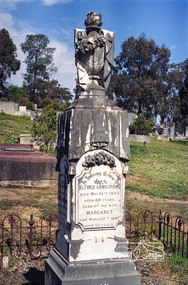
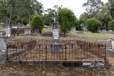
Photograph, Peter Pidgeon, Grave of Alfred and Margaret Armstrong, Eltham Cemetery, Victoria, 5 April 2021
Alfred Patrick Armstrong was born in England in 1825 and was employed under the renowned Isambard Kingdom Brunel as a civil engineer during the construction of the Great Western Railway and the South Wales Railway. He came to Melbourne in 1852 and purchased property in Eltham. He became a mining surveyor and was Inspector of Mines and the Mining Registrar for the St Andrews Division of the Castlemaine Mining District. In 1855, he chaired a meeting calling for a bridge to be erected across the Yarra River between Eltham and Temple Stow. He was registered as an innkeeper in 1858, was a recognised collector of the £110 raised for the building of the first building of State School No. 209 (Eltham Primary) and was a Trustee for the Church of England site on the Eltham Cemetery Trust in 1860. He was elected to the Eltham District Road Board (forerunner of Eltham Shire Council) from 1867 to 1871 and then served as an Eltham Shire Councillor from 1871 to 1878 (including Shire President in 1873). Margaret Armstrong to whom he was married in 1854 at St Pauls Church, Melbourne, died on the 27th March 1887. Alfred died in 1893, having been in ill health for some time, and is buried in Eltham Cemetery with his wife Margaret. The monument features a tall pillar capped with a draped urn: a symbol of death. In Loving Memory of Alfred Armstrong Died May 27tth 1893 Aged 68 years Also of his wife Margaret Died March 27th 1887 Aged 63 years This burial site is of special interest as the monument has the tallest pillar-a vase-a draped cloth top (unfulfilled life) and additional panels of names around the sides and the base, which include: Ada Gertrude Armstrong, beloved daughter of Alfred & Margaret Armstrong, died May 30th 1878, aged 21 years Mary Armstrong, beloved mother to Alfred Armstrong, died April 10th, 1886 aged 82 years Arthur Vivian Harrison, died 4th Nov. 1899, aged 8 years Arthur Reynolds Stockwood Armstrong, son of Alfred Armstrong, died 4th Nov. 1908, aged 43 years Laura Augusta Harrison nee Armstrong, died 26th July 1921, aged 64 yearsBorn Digitaleltham cemetery, gravestones, ada gertrude armstrong, alfred armstrong, arthur reynolds stockwood armstrong, arthur vivian harrison, laura augusta harrison (nee armstrong), margaret armstrong, mary armstrong -
 Eltham District Historical Society Inc
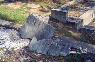
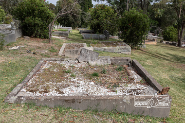
Photograph, Peter Pidgeon, Grave of Richard George, Emily Ann (nee Davis) and Edith Jane Kaylock, Eltham Cemetery, Victoria, 5 April 2021
In his early adult life, Richard Kaylock worked as a whaler (visiting California and New Zealand) and later as a drover on a large cattle station in New South Wales. In 1848 he came to Melbourne, working as a slaughterman, then settled in Eltham in 1854, his occupation thereafter being variously recorded as butcher or orchardist. He also had some experiences at Ballarat during the Eureka Rebellion. He died in 1910 at the age of 84. His obituary described him as a "striking personality" who was "brusque to a fault" and "strictly upright, expecting others to be the same". It seems from his will that he was illiterate. He is buried in Eltham Cemetery with his wife Emily. His property was in Wellington Street (now Brougham Street) and apparently extended across the Diamond Creek. The land on the western side of the creek was farmed, the house being on the eastern side. For many years the Brougham Street bridge was generally known as "Kaylock's Bridge". It formed part of the original coach road to Eltham and in 1922 was described as an "old rustic bridge". Its low level and insubstantial construction made it susceptible to flood damage, necessitating frequent closures until repairs could be carried out. The original bridge was demolished in 1923 and replaced by a "new up-to-date" one. When a lack of finances delayed repairs to the Bridge Street bridge in 1931, traffic had to detour via Brougham Street for some time. Local residents feared that the Bridge Street bridge might never reopen. In Loving Memory Of Our Dear Father & Mother R.G. and E.A. Kaylock Also E.J. Kaylock Died 21st Jan. 1927 The Eternal God Is My PledgeBorn Digitaleltham cemetery, gravestones, brougham street bridge, edith jane kaylock, emily ann kaylock (nee davis), kaylocks bridge, richard george kaylock -
 Eltham District Historical Society Inc
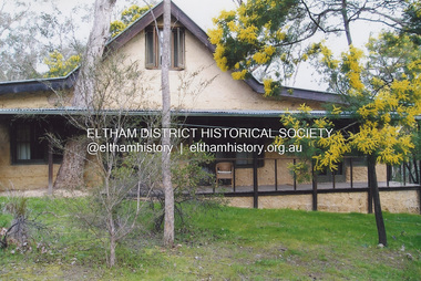
Photograph, Fay Bridge, Birrarung House, 195 Laughing Waters Road, Eltham, 7 September 2013
... , "Laughing Waters Road; Art, Landscape & Memory in Eltham" published ...Laughing Waters Walk, 7 Sep 2013 This Society excursion was a follow up to the Laughing Waters Story told to us by Jane Woollard at our Annual General Meeting in March 2013. It involved a walk commencing from the corner of Laughing Waters and Overbank Roads along Laughing Waters Road to its eastern end and returning partly over the same route - a total distance of about 2.5km. On the way we visited the two artist in residence properties, River Bend and Birrarung, to view the houses on them that are associated with Alistair Knox, Gordon Ford and others in the local mud brick and artistic community. We also able to walk around the derelict ruin which was once home to Gordon and Sue Ford, Boomerang House. An unexpected afternoon tea was offered to us by the artists in residence at Birrarung House and we had a brief opportunity to view inside the house. Birrarung is situated near the end of Laughing Waters Road. It was built in 1974 by Graeme Rose for Gordon Ford who he had asked to build him a small ‘bach’. Builder Peter Jarvis who did his apprenticeship with Alistair Knox for a couple of years recalled there were no drawings. It evolved as more funds became available. Graeme would source second-hand building materials around which he would shape the house. The fireplace was built with chicken wire over which it was rendered with faro cement. A brick floored glass studio, added later, faces a wall of boulders pressed into a manmade cliff, a large pond the link between the rock wall and glass studio. A waterfall, fed by river water, no longer functions. The property became part of the Laughing Waters Artist in Residency Program with the first artist taking up residency in 2001. For a more in-depth description of the property and biographies of the various artists in residence commencing from 2001 through to 2015, see Jane Woollard's book, "Laughing Waters Road; Art, Landscape & Memory in Eltham" published 2016.2013-09-07, activities, artists in residence, eltham district historical society, heritage excursion, laughing waters road, birrarung house, fay bridge collection -
 Eltham District Historical Society Inc
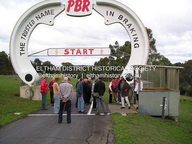
Photograph, Fay Bridge, Rob Roy Hill Climb Circuit, Clintons Road, Christmas Hills, 7 September 2013
Rob Roy-EDHS visit 12 May 2016 On 12th May 2016 some members of the Eltham District Historical Society and others were fortunate to have the opportunity to visit and explore the Rob Roy Hillclimb in Clintons Road, Christmas Hills. This followed an invitation from Don Kinsey and Wayne Ruston, members of the MG Car Club, which operates Rob Roy. At the time, both men were actively involved in the running of the meetings there, Don, an EDHS member, as a course commentator, with a wide range of motorsport experiences, and Wayne as the main organiser of the meetings. Don Kinsey welcomed the group and spoke about the historical background of the property and the hillclimb, then led those interested around the site and up the hillclimb track, stopping at spots along the way to provide additional information. Everyone enjoyed their experiences, including inspecting Wayne Ruston’s MGBV8. The Rob Roy Hill Climb originated in 1935 on the property of former Heidelberg Mayor, William Clinton, where he reared the Rob Roy breed of miniature ponies. He established Pleasure Grounds on part of the property attracting groups of Sunday visitors from Melbourne's inner suburbs. Visitors enjoyed a picnic area, pony rides, a dance hall and a tap room. Young men would ride their BSA or Harley Davidson motorcycles to the property which led to regular club-organised hillclimb meetings between 1930 and 1936. In 1935 Clinton offered the use of his property to the Light Car Club of Australia for their hillclimbs. The track was sealed that same year and the hillclimb at Clintons Road was one of only three specially designed bitumen surface hillclimbs in the world, the others being Shelsey Walsh and Prescott Hillclimbs in the UK. The first Light Car Club of Australia hillclimb was held at Rob Roy in February 1937.activities, eltham district historical society, heritage excursion, fay bridge collection, 2016-05-12, christmas hills, clintons road, rob roy hill climb