Showing 3443 items matching "distance"
-
 Mont De Lancey
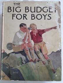
Book, Blackie and Son Limited, The Big Budget for Boys, c1930's
Book read by family members, especially Lance Sebire who was awarded it from Sunday School in 1936Large hardcover children's book for boys with coloured picture on front cover of two boys sitting on a rock, one looking through binoculars and the other pointing into the distance. The title, The Big Budget for Boys is printed in black lettering on the front and spine with an illustration of another boy and the publisher. The back cover is also illustrated in colour with two more boys reading a map. The collection of adventure stories have black and white illustrations throughout.Mrs Les Gaudion's Class - Methodist Sabbath School Wandin Yallock. Awarded to Lance Sebire for Diligence and Attendance. Mr J H Lord Supt. Harold Blanksby Sec. May 18th 1936. The Book Depot, 288 Little Collins Street (Methodist Book Buildings)adventure, young people's fiction, children's fiction, children's book -
 The Ed Muirhead Physics Museum
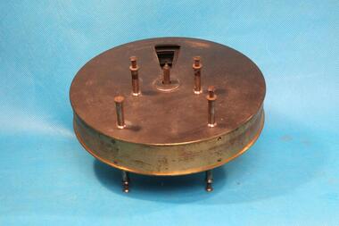
Instrument - Becquerel Phosphoroscope (incomplete), c1860-1880
The phosphoroscope was invented by Alexander Edmund Becquerel and used to measure the amount of time that a phosphorescent substance will glow after being irradiated by a brilliant source of light.The phosphoroscope consists of a round metal chamber with a pair of rotating discs inside, arranged so that no light can pass directly through the chamber. The discs have cut-out windows spaced equally at regular angular distances and are turned by the hand crank linked to a gear mechanism. The sample is placed in a specially designed holder into the small opening near the gearing, and it is exposed to the light source through the large rear condensing lens.Engraved on chamber: 'Phosphoroscope de E. Becquerel / J. Duboscq a Parisbecquerel phosphoroscope, phosphoroscope, optical instruments, phosphorescent, alexander edmund becquerel, jules duboscq, france -
![Painting: Park Street [Adeney Avenue] Kew](/media/collectors/550653872162f11fb04854aa/items/5826877cd0cdd11284ad5413/item-media/614ac683a53a0756fd5e49da/item-fit-380x285.jpg) Kew Historical Society Inc
Kew Historical Society IncPainting, Park Street [Adeney Avenue] Kew, c. 1896
‘Adeney Avenue’ was the title given to this painting following its donation to the Kew Historical Society, yet the work’s origins predate the naming of Adeney Avenue in 1907 [originally gazetted as ‘Park Street’ (1865) and ‘Park Street South’ (1875).] Park Street ran between High Street and Parkhill Road beside what was later to become ‘Victoria Park’. This area was described in 1851 as “…a dense forest of gums and wattles which were to be largely cleared by 1888 after the naming of a recreation reserve”. The Reserve was still bisected by an unnamed creek in 1896, when the area was surveyed by the MMBW. The panoramic vista selected by the artist would appear to include ‘Eborensis’ (c.1895) on the corner of Parkhill Road and what was then Park Street, with views across cleared land towards the distant ranges. In the 19th century, north Kew was largely undeveloped farms stretching down to the Yarra. Oil on canvas by an unidentified artist of a panoramic view depicting what is now known as East Kew with mountains on the horizon. In the foreground is a two storey brick residence - Eborensis - located on the northeast corner of Parkhill Road and what is now Adeney Avenue. The view of the landscape and its rolling hills resulted from farming practices adopted following colonisation and settlement. Trees in the foreground and in the distance include remnant Eucalypts and introduced exotics.Label on rear of frame states "House on corner of Adeney Ave & Parkhill. [Regd. 254"]. Otherwise unsigned and undatedadeney avenue (kew), eborensis, park street (kew) -
 Melbourne Tram Museum
Newspaper, The Age, “Three-step plan for safe public transport”, 1/05/2020 12:00:00 AM
Newspaper clippings titled: “Three-step plan for safe public transport” by Timna Jacks Newspaper clipping from the Age 1/05/2020 Covers planned restrictions for safe public transport use due to Covid-19. Suggesting public transport should run half empty with no standing room to enable commuters to observe a safe distance. Capacity on trams could suffer leaving services at 13% capacity.trams, tramways, public transport, melbourne, safety, covid-19 -
 Lakes Entrance Historical Society
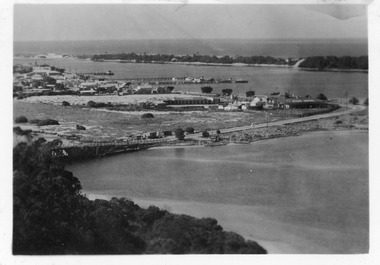
Postcard - Aerial view of Lakes Entrance, 1940c
Also 1 Black and White Photographic copy 12.5cmx17.5cm, fair condition P01154-2Black and White Photographic miniature postcard showing the southern abutment of the North Arm Bridge, town, including Club Hotel and garage, sand, hummocks and in distance, the footbridge across Cunninghame Arm. Workmens huts at bridge approach, motor car and truck parked westside of bridge approach. Boats in western boat harbour. Atlantic Ethyl sign behind Club Hotel, and tanks on tall tankstands. Lakes Entrance Victoriabridges, coast, hotels, boats and boating, fences, transport -
 Lakes Entrance Historical Society
Photograph - Recreation Area Development Lakes Entrance, Lakes Post Newspaper, 1/04/1999 12:00:00 AM
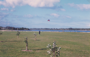
Colour photograph taken of the newly planted trees on the recreation area east of the footbridge. The artificially constructed knoll beside lake in the distance one person flying a kite from lawn Lakes Entrance Victoria. Also three colour photographs showing progress of recreation area east of the footbridge and instillation of rotunda. Small boy in foreground is Jarrod Elstob of Paynsville 04270.1, 04270.2, 04270.3 size 10 x 15 cmtownship, waterfront, recreation -
Federation University Historical Collection
Booklet, Ballarat School of Mines Annual Report, 1901, 1901
In 1901 Andrew Anderson was President of the Ballarat School of Mines. At the height of its world wide fame the annual report states: 'That the public recognises and appreciates the importance of the School, is evident by the large additions to the class rolls - (many of the students have come long distances, from England, India, South Africa, new South Wales, Queensland, West Australia, South Australia and Tasmania,) which give ample proof, if such were necessary, of the wide spread reputation of the School.'8 page booklet relating to the Ballarat School of Mines in the year 1901. It includes information on: Alfred Johnston's death during the Boer War, Thomas Bath's bequest to the Ballarat School of Mines, resignation of Theophilus Williams from the School Council, appointment of Richard Maddern and Isaiah Pearce to the School Council, Associateship courses, New mining metallurgical laboratory and a statement of receipts and expenditure ballarat school of mines, andrew anderson, thomas bath, alfred gresham johnston, boer war, rhenoster kop, south africa, richard maddern, isaiah pearce, salariesmining laboratory, metallurgical laboratory, wynne tables, tregurtha tables, halley's percussioina tables, wilfley concentrator, spitzkasten, jig, linkenback table, chilian mill, amalgamator, model agitation plant, slime vats, alfred mica smith, william gurr, thomas hart, museum, fees, mining plant, model mine, allendale excursion, daylesford excursion, botanical excursion, geological excursion, melbourne excursion, itonworkers' association -
Unions Ballarat
Photograph: ALP Lunch at Creswick Landcare Centre, 18/2/2001
The picture is taken at an ALP lunch. There are several unidentified people (sitting) in the photograph. The photo has been taken from a distance, but it is known that Sheryl Garbutt attended this lunch. Ms Garbutt was electorate officer to Pauline Toner. She won the state seat of Greensborough at a by-election and subsequently was elected as member for Bundoora. She held several shadow ministry positions and, after the election of the Bracks Government, Ms Garbutt served as a cabinet minister. She retired in 2006.Photographbtlc, ballarat trades and labour council, ballarat trades hall, garbutt, sheryl, politicians - state, alp, australian labor party -
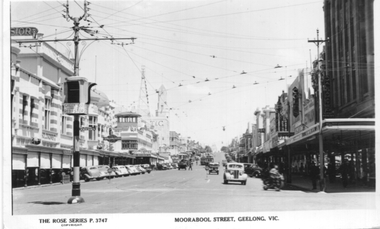 Ballarat Tramway Museum
Postcard, Rose Stereograph Co, "Moorabool Street Geelong Vic", 1949
Postcard produced by the Rose Stereograph Co. No P 3747, showing the scene at the corner of Moorabool and Ryrie Sts Geelong. Has a tram in the far distance turning out of Malop Street along with many motor cars of the late 1940s. In the view are Bright and Hitchcocks, the T&G building, Bank of NSW, Coles, and the Amalgamated store. Also in the view is one of the Bar neon-type traffic lights that Geelong installed. The rear of the postcard notes that it is a real photograph. Yields information about the view of Moorabool St at Ryrie St.Black and white Postcard divided back, unused. On top right hand rear is "1949"tramways, trams, geelong, moorabool st, ryrie st -
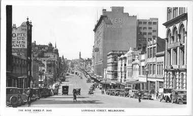 Melbourne Tram Museum
Postcard, Rose Stereograph Co, "Lonsdale Street Melbourne', c1933
Rose Series postcard No. P 3645, titled "Lonsdale Street Melbourne', looking east from Queen Street. Has several cable trams in the far distance at Swanston Street. In the view is the Myer Emporium Lonsdale Street store and the Eastern Hill fire station tower. There are adverts for Dulux, Tribune, Wynss, Fox films, A E Hoad? Stillwell Stephens. The cable trams in Lonsdale Street west of Elizabeth Street closed in early 1935 and the remainder in 1939. Yields information about Lonsdale St c1933.Postcard - printed real photograph with Rose Stereograph Co. name on the rear.Has the 3rd part of a letter to Ken on the rear.trams, tramways, cable trams, lonsdale st, myer -
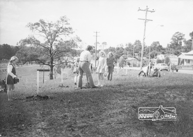 Eltham District Historical Society Inc
Photograph, ELTHAM ARBOR DAY 1973 - Alistair Knox with school children of the Shire of Eltham, Vic, planting native trees in the Town Park, 10 October 1973, 1973-10-10
ELTHAM - ARBOR DAY, 10 Oct 1973. School children of the Shire of Eltham planting trees (previously planned to take place during the visit of Sir Rohan Delacombe to the Shire on 19th September, 1973 but cancelled that day due to inclement weather). REF: 783 SOURCE: Shire of Eltham (Eltham District Historical Society) Eltham Town Park would later be renamed Alistair Knox Park Looking north along Main Road; Eltham Shire Office in distanceBlack and white photographeltham, arbor day, alistair knox, alistair knox park, eltham town park, main road, eltham shire office -
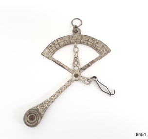
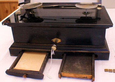 J. Ward Museum Complex
Tool - Measuring Scales
The traditional scale consists of two plates or bowls suspended at equal distances from a fulcrum. One plate holds an object of unknown mass (or weight), while known masses are added to the other plate until static equilibrium is achieved and the plates level off, which happens when the masses on the two plates are equal. Medication given to patients at both Aradale Mental Hospital and J Ward had their does measured using these weights and scales - and some evidence of residue remains.The scales are in excellent condition and a good example of medical equipment used in Aradale Mental Hospital and J Ward. Measuring scales for medications Timber construction with glass lid Small crack along the left hand side of scales Two drawers contain four weights in ounces Case painted in black lacquer Metal hinges and three brass knobs (one missing from right lower drawer) Small piece of folded butcher paper in left hand drawer No manufacturer markings or serial numberspsychiatric history, mental health, aradale mental hospital, j ward -
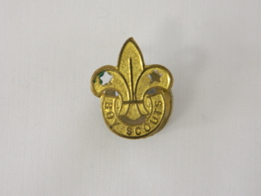 Kiewa Valley Historical Society
Badge Boy Scout, circa mid to late 1900's
This badge, which was used in the mid to late 1900's (Scouts started in Australia in 1909) clearly demonstrates that the families in the Kiewa Valley although slightly remote were still able to participate in one of the prime "boy" only social groups. The Boy Scouting movement brought together boys from all the socio-economic areas in the Australian population. The scouting group applied the concept of self sufficiency and friendship to all its membership. It was an avenue to cross the boundaries of distance and regional mores. Many of the boys in the Kiewa Valley and its regions would have been more "in tune" with the core principles of the scouting movement because being in a rural environment and "living on the land" was a day to day part of their life. What was an important aspect to they was the "mateship" and the belonging to a very large, and international, group of "like minded" boys. This avenue of interacting with a larger group of boys cut through the "small population" mores of a rural and at times isolated environment. This Boy Scouting activity was both mentally and physically significant to growing boys within the Kiewa Valley as it opened up the world to them.This brass badge has a front formed in a half circle base supporting a "Fleur de Leis" in a spear shape with "cut outs" at the appropriate places to provide the emphasis needed to project the form. Attached to the badge is a crescent moon shaped pronged frame for attaching the badge to lapels or collars or button eyelets. On the bottom scroll "BOY SCOUTS" and on the back type fastener "STOKES & SONS" below this "Melb".societies, boy scouts, apparel badges, numismatics badges -
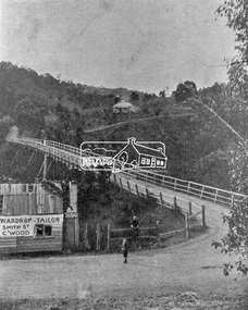 Eltham District Historical Society Inc
Photograph, Warrandyte Bridge on River Yarra
Bridge across the Yarra River which links North Warrandyte and Warrandyte. A house sits prominantly on a hill in the distance. A wooden building on the side of the road before the bridge has advertising for Wardrop Tailor, Smith Street, Collingwood. It is suggested that the photo has had this fake information added at a later date. Wardrop Tailor did operate from about 1915 to 1921. Alternataive title: Warrandyte Bridge - River Yarra. "Wardrop-Tailor, Smith St. C'wood" sign - faked?This photo forms part of a collection of photographs gathered by the Shire of Eltham for their centenary project book,"Pioneers and Painters: 100 years of the Shire of Eltham" by Alan Marshall (1971). The collection of over 500 images is held in partnership between Eltham District Historical Society and Yarra Plenty Regional Library (Eltham Library) and is now formally known as 'The Shire of Eltham Pioneers Photograph Collection.' It is significant in being the first community sourced collection representing the places and people of the Shire's first one hundred years.Digital imagesepp, shire of eltham pioneers photograph collection, warrandyte, bridge, north warrandyte, yarra river, wardrop tailor, collingwood -
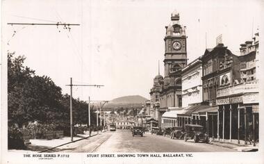 Ballarat Tramway Museum
Postcard, Rose Stereograph Co, "Sturt Street showing Town Hall, Ballarat Vic.", early 1930's
The photo is of Sturt St showing Town Hall Ballarat Vic, looking east towards Grenville St from Doveton St. An ESCo tram is in the far distance, possibly with a Vote No sign along with a few early motor cars. In the view are Stansfield and Smith, F. Gallagher, Morseheads, Myer, The Bucks Head Hotel, and a sign for Rolfes. Note - very similar in location to item 8242, an earlier Rose Series photo with the same number 1712. Two copies held.Yields information about the appearance of Sturt St in the early 1930's, tram operations, buildings and motor vehicles.Postcard - black and white - titled The Rose Series P1712 - A divided back postcard with the rose symbol, publisher details on the left side and that it is a real photograph. trams, tramways, sturt st, doveton st, town hall, esco, rose postcards -
 Sunbury Family History and Heritage Society Inc.
Photograph, Painting school sign, 1988
In 1988, the senior students at Bulla Primary School, under the supervision of their teacher undertook a community activity to paint a school sign that could be seen from a distance. They collected rocks that were lying across the exposed hillside above the school and arranged them into the word 'BULLA'. They then painted the rocks with white paint. Anyone approaching Bulla township from Sunbury would see the sign across the valley. The sign remained there for the following eight years but was dismantled when the school property was sold.The painted sign on the hillside became an important signpost for people travelling into the township as it was visible even from a low flying aircraft, which were either descending to land or had just taken off from the nearby airport.A non-digital coloured photograph of four children and an adult painting rocks on a hillside.bulla primary school, school painted sign, bulla township -
 Falls Creek Historical Society
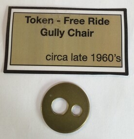
Ski Lift Token - Gully Chair
This token was used at Falls Creek for one free ride on the Gully Chair. The Gully Chair was constructed in 1964 by McCallum Engineering. Ron McCallum built 16 lifts throughout Australia from 1954 to 1970. It had a Doppelmayr drive and some other moving parts. The Gully Chair was a two seater fixed-grip chair. It had a length of 456 metres and a vertical distance of 76 metres. This Chairlift operated from 1964 until 1981. It was replaced in 1982 by the Gully triple chairlift.These tokens are significant because they represent a stage in the progression of chair lifts and technical developments at Falls Creek.A circular metal token with two smaller circles cut out of the centre.falls creek chairlifts, chair lift tokens, gully chair -
 Melbourne Tram Museum
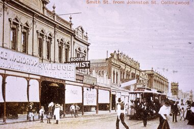
Slide - Colour - reproduction - Smith St Collingwood from Johnston St - c1900
Reproduction slide of a coloured postcard showing a cable tram in Smith St Collingwood, south of Johnston St. Has a Clifton Hill bound cable tram in view. The conductor with trip slips appears to be walking forward to check for cable trams in Johnston St as required by the rules. Passengers are alighting from the tram. Shops are E Wardrop, W Luge, Booth Chemist and Dentist, and in the far distance is a Moran and Cato store. Many of the shop awnings have been lowered. Yields information about Smith St Collingwood and cable tram operations.Kodachrome cardboard duplicate slide - Colour slide - reproduction - Smith St Collingwood from Johnston St - c1900 "CB20" in penciltrams, tramways, cable cars, cable trams, collingwood, smith street -
 Melbourne Tram Museum
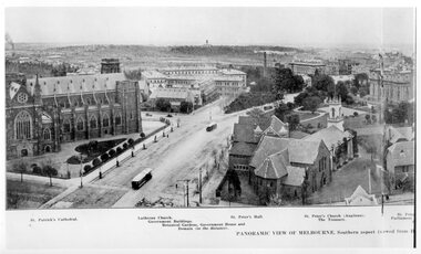
Photograph - Illustration, Panoramic View of Melbourne Southern Aspect
Illustration titled - "Panoramic View of Melbourne Southern Aspect" photo from the Eastern Hill Fire Station watch tower, late 1890s early 1900s of a view looking south. There are three maybe four cable trams in the view. The photograph notes the St Patrick's Cathedral (consecrated in 1897), the German Lutheran Church, Government offices, Treasury Buildings, Government House in the far distance, St Peters Church, and the Victorian Parliament building. The photo looks along Gisborne and Macarthur Streets.Yields information about the Eastern Hill and Parliament precinct late 1890's early 1900's.Black and white print of a published illustration - Panoramic View of Melbourne Southern Aspecteastern hill, cable trams, st patrick's cathedral, gisborne street, macarthur street, st peters church -
 Melbourne Tram Museum
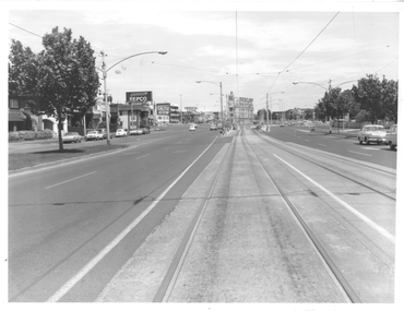
Photograph - St Kilda Road looking south, Melbourne & Metropolitan Tramways Board (MMTB), c1975
Photograph of the south end of St Kilda Road, before the full reconstruction of High Street St Kilda (now St Kilda Road) but after the reconstruction of the Queens Road underpass, photo c1975. Shows the buildings at the junction including the Tower Hotel in the distance. Signs for advertising include Repco, Caltex Astron, UniRoyal Tyres, and Dunlop Tyres. The "Timeline history of Melbourne Tramways etc Barry George et al" gives the date of the opening of the High St section as March 1975.Yields information about the redevelopment of St Kilda Junction.Black and White Photograph with notes on the rear.On rear of photograph in ink "St Kilda Road Junction Stage One complete c1975"trams, tramways, high st, st kilda junction, st kilda rd -
 Flagstaff Hill Maritime Museum and Village
Instrument - Letter Scale, Ca. early 20th century
This handheld portable pendulum quadrant scale was used to weigh small paper items such as letters and documents, powdered chemicals or metals like gold, and animal fleece samples. This mechanical scale can weigh up to a maximum of 10 ounces, which is about 285 grams or one-and-a-half cups of brown sugar. The operator holds the scale’s ring and connects the item to be weighed onto the wire clip. The weight of the item causes the pendulum to pivot, and the scale measures the weight of the object, indicated by the arrow. This scale belonged to Dr William Roy Angus and is now part of Flagstaff Hill’s comprehensive W.R. Angus Collection, donated by the family of Dr W R Angus, 1901-1970, surgeon and oculist. The W.R. Angus Collection: - The W.R. Angus Collection includes historical medical equipment, surgical instruments and material belonging to Dr Edward Ryan and Dr Thomas Francis Ryan, (both of Nhill, Victoria) and Dr Angus’ own belongings. The Collection’s history spans the medical practices of the two Doctors Ryan, from 1885-1926 plus that of Dr Angus, up until 1969. It includes historical medical and surgical equipment and instruments from the doctors Edward and Thomas Ryan of Nhill, Victoria. Dr Angus married Gladys in 1927 at Ballarat, the nearest big city to Nhill where he began as a Medical Assistant. He was also Acting House surgeon at the Nhill hospital where their two daughters were born. During World War II He served as a Military Doctor in the Australian Defence Force. Dr Angus and his family moved to Warrnambool in 1939, where Dr Angus operated his own medical practice. He later added the part-time Port Medical Officer responsibility and was the last person appointed to that position. Both Dr Angus and his wife were very involved in the local community, including the planning stages of the new Flagstaff Hill and the layout of the gardens there. Dr Angus passed away in March 1970.This letter scale is the only one of its type in our collection. It is an example of objects belonging to Dr. W. R. Angus, 1901-1970, surgeon and oculist. The W.R. Angus Collection is significant for still being located at the site it is connected with, Doctor Angus being the last Port Medical Officer in Warrnambool. The Collection includes historical medical objects that date back to the late 1800s.Letter scale, a handheld quadrant fixed pendulum scale made from silver-plated metal. This small weighing instrument is shaped like a quarter-circle with a metal ring, a fixed pendulum counterweight and a decorative pivoting arrow indicator. A hanger clip is attached to a short arm of the scale. Measurements are embossed on the arc of the circle, labelled in ounces (oz) and ranging from 0 to 10 at unequal distances apart. The scale is part of the W.R. Angus Collection.Scale measurements, "OZ" (ounces), "0 /14 1/2 1 2 3 4 5 6 7 8 9 10 "flagstaff hill, warrnambool, maritime village, maritime museum, shipwreck coast, great ocean road, flagstaff hill maritime museum and village, dr w r angus, mira hospital, w.r. angus collection, scale, weighing instrument, measure weight, postal scale, chemist scale, letter, weigh, post, office, quadrant scale, letter scale, handheld, portable, mechanical scale, pendulum scale, fixed balance scale -
 Ringwood and District Historical Society
Map, Plan of the Parish of Warrandyte County of Evelyn - 1841
Blueprint copy of Survey Map W27 detailing original Selectors' names and property locations between Yarra Yarra River (Warrandyte) and Mullum Mullum Creek (Ringwood). List of Parish map references including property bearings, distances in Links, and markings on trees. Pound Bend area of Warrandyte marked as Reserve For Aborigines. Descriptive remarks include areas marked "scrubby, flat, sandy soil". Several other references faded and illegible.(Map) by T.H. Nutt Feb 3 1841. -
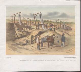 Bendigo Historical Society Inc.
Painting - CAROL HOLSWORTH COLLECTION: 1970 NATIONAL BANK PAINTING 'DEEP SINKING - BALLARAT'
1970 National Bank painting reproduction 'Deep Sinking , Ballarat' by S.T.Gill c. 1855 Below the picture title the words - Reproduced by the National Bank in 1970 from the lithograph in the La Trobe Collection , State Library of Victoria , by permission of the Library Council of Victoria .Also on the painting is written -James J Blondell & Co Melbourne 1855. The painting shows mine shafts with windsails and windlasses a horse and cart , three men in the foreground several in the distancepainting, watercolour, gold diggers -
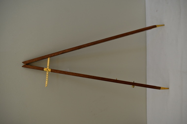 Dandenong/Cranbourne RSL Sub Branch
Instrument - Pace Stick
The Pace Stick is used to measure the correct length of pace. Rhythm and uniformity in marching is achieved by using the Pace Stick as well as the drum and metronome. Correct pace length is necessary not only for ceremonial purposes, but also to reduce fatigue on long marches and set the standard of accuracy required of soldiers. The Pace Stick is actually two pieces of timber, hinged at the top and able to be set to a particular distance, something like the compass set you used at school. -
 Ballarat Tramway Museum
Photograph - Digital image, 5/08/1941 12:00:00 AM
Yields information about Sturt St streetscape from near Dawson St, after a snowstorm, looking east.Digital image from the Wal Jack Ballarat Album of a photograph of the Sturt St median strip looking east from near Dawson St during a snow storm on 5-8-1941. Has tram 27 in the far distance. On the right hand side are Harry Davies Co and Scott Chemist buildings. Thought to be a Wal Jack photo as it is his handwriting on the rear, but no negative number. See image i2 for rear of photograph.On rear of photograph in ink "Ballarat No. 27 Sturt St, in snow scene 5th August 1941"trams, tramways, sturt st, snowstorm, tram 27 -
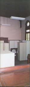 Kew Historical Society Inc
Photograph - Former Kew Court House : Court Room, 1996
A civic campaign for new public offices developed in Kew in the 1880s. After much deliberation, the location chosen was the junction of Bulleen and Cotham Roads. The buildings were designed by George Watson and John Henry Harvey, architects within the Department of Public Works (Victoria). Building was commenced in 1887, and after one year, the buildings were opened. The Post Office was transferred to the new Commonwealth Government in 1901. The Police Station and Court House, sold by the Victorian Government to the City of Boroondara in 2007, are now a community cultural centre and performing arts venue.The buildings were listed on the Victorian Heritage Register Register (HO885) in 1991. They are historically and architecturally significant to the State of Victoria because Watson and Harvey's designs exhibit diversity in integrating civil offices, they accommodate the apex of road junctions, and they demonstrate a departure from the contemporaneously favoured High Victorian Classical to the Queen Anne style in the design of civic buildings.Former court room of the Kew Court House. By 1993 when this photograph was taken, the room had been taken over by the Kew Police Station and used for police lockers and as a briefing room. In the foreground the edge of the magistrates' desk can be seen and in the distance the railing used to separate the public gallery from the main section of the court. This railing was repositioned to the foyer during the renovations of the Court House from 2007-11. The magistrates' desk was destroyed. kew court house, public offices -- kew (vic), kew police station -
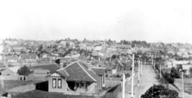 Surrey Hills Historical Society Collection
Photograph, Surrey Hills viewed from 'Quamby' at 293 Mont Albert Road, c 1915, 1915
Quamby was built in 1898. From 1900/1903-1924 it was the home of Andrew Sherar and family. From 1924-1960s it operated as Mosgiel Hospital under the direction of Matron Elizabeth Anderson. Until Box Hill Hospital opened most Surrey Hills children were born at Mosgiel or at Nethercourt Hospital in Wilson Street or later in Union Road when Matron Tank moved her hospital here. Mosgiel Hospital was demolished c 1975 after it was sold by Box Hill Hospital. It was replaced by units. Andrew Sherar was conductor of the Wyclif Church choir for many years and was a member of the Melbourne Liedertafel. Isie Sherar was organist at Wyclif Church and also taught piano in Union Road. Connie Sherar was in the Wyclif choir and married Ernest Swan, an elocutionist and orator. Dorothy Sherar was a pianist and accompanist. Elsie Sherar was also in the Wyclif choir and was a soloist; she later moved to Templestowe. Ken Sherar was a boy soprano at St Paul's Cathedral; he later moved to Queensland.Black and white photo looking south down Vincent Street from 'Quamby', located at 293 Mont Albert Road, Surrey Hills. In the centre foreground is a timber house with 2 chimneys and a tiled hip roof. It has a return veranda and is fenced on 2 sides by paling fences and picket fences on the other two. In the background are many more houses. A road lined with power poles runs from the right foreground to the middle distance.quamby, vincent street, edwardian style, topography, andrew sherar, isie sherar, connie sherar, dorothy sherar, ken sherar, elsie wappet -
 Stawell Historical Society Inc
Photograph, Magdala cum Moonlight Mine with tailings dam & the Grampians in the background. c1900's
Magdala cum Moonlight Mine. Wide view of mine with Grampians Mountains in background.Mine with snow. The Cyanide plant was constructed in Sept 1900 and became the largest in Victoria. Just in front of the large tree a ramp can be seen and a horse and dray going up the ramp. Just below and to the left of the tree the cyanide vats can be seen. On the right is the poppet head of the Magdala and Oriental and North Cross Mine. The fire station is on the left in the far distance. with the W S Heal & Sons Coachbuilders Corner of Lazelle and Byrne Street businessMagdala Cum Moonlight Mine. Herbert's Studio. Stawellstawell gold mining -
Linton and District Historical Society Inc
Notebook, St Patrick's Day Races, Linton, 1929
The St Patrick's Day sports meeting was an annual event in Linton during the 1920s and 1930s. In 1929 the events included running races for children, horse racing and motor car driving. R. O'Beirne was Secretary of the sports day committee.Green 'Banco' exercise book which contains information compiled for the St Patrick's Day Sports held March 9th 1929. Includes timetable of events, information on race distances, horses entered in races, penalty weights, handicaps, protests lodged, amounts paid in winnings etc. Also includes brief information on entries, winners and prize money paid for "Motor Car Driving" and "Musical Chairs in Cars" events, and summary of takings for the day.On front cover: "R.O'Beirne, St Patrick's Day Races, March 9th 1929, Commenced 9th/2?[illegible]/1929". Inside front cover: "1929 1930". Inside back cover: Race notes in pencil.events, st patrick's day sports, horse racing, r.o'beirne -
 Melbourne Tram Museum
Slide, Keith Caldwell, 25/04/1964 12:00:00 AM
Agfa colour slide, blue / white plastic mount, photo by Keith Caldwell W7 771, northbound in Elizabeth St at the corner with Therry St Melbourne. Tram has destination of North Coburg, Route 19. In the background is the Commercial Bank of Australia (CBA), the Victoria Market Post Office and the city depot of Henderson's Springs. Both corner buildings remain in position. Note the short distance between the tram stops. 25/4/1964In ink "Zone Eliz Nr Vict 25.4.64"trams, tramways, w7 class, route 19, victoria market, north coburg, elizabeth st, tram stops, tram 771