Showing 213 items matching " county of bourke"
-
 City of Moorabbin Historical Society (Operating the Box Cottage Museum)
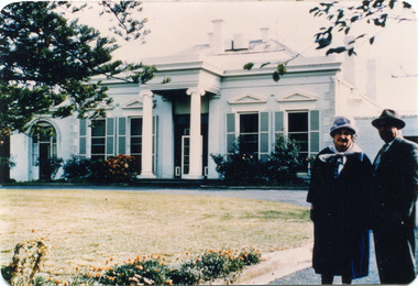
Photograph, Black & White, 'Oak Bank' later 'Whitehouse' Ann St. McKinnon c1920, c1960
... moorabbin, city of moorabbin, county of bourke, moorabbin roads... of moorabbin, city of moorabbin, county of bourke, moorabbin roads ...'Oak Bank ' , in Ann Street McKinnon, was originally owned by Mr Robert Smith. The house was later renamed 'The Whitehouse' and was still in use as a General Hospital in the 1950's, known as the Ann Street Hospital.. This small hospital handled some Surgery, Midwifery and general Medical cases from the fast growing Bentleigh / McKinnon area. As time progressed the Hospital became too small, and was unable to meet new medical standards When Moorabbin Community Hospital opened c1974 in Centre Road East Bentleigh, the Ann St Hospital closed. The Moorabbin Hospital is now a campus of Monash Medical Centre Clayton. 'The Whitehouse' was used as a general Hospital for the residents of McKinnon, Bentleigh, and Ormond for many years during the 20thC.Colour photograph showing Mrs John Marriott ( nee Ann Smith) , her son Fred Marriott standing outside 'The Whitehouse' undated ? c1960Back ; Handwritten informationoakbank house mckinnon, whitehouse mckinnon, ann street general hospital, moorabbin community hospital, monash hospital clayton, smith robert, lees seedling growers ltd. thomas street mckinnon,mith j l; smith mary ann, stanley helen, smith vic, chaff cutter, horse drawn carts, toll gates brighton, motor cars 1900, steam engines, early settlers, bentleigh, mckinnon, parish of moorabbin, city of moorabbin, county of bourke, moorabbin roads board, shire of moorabbin, henry dendy's special survey 1841, were j.b.; bent thomas, o'shannassy john, king richard, charman stephen, highett william, ormond francis, maynard dennis, market gardeners, vineyards, orchards -
 City of Moorabbin Historical Society (Operating the Box Cottage Museum)
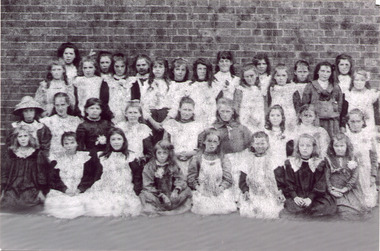
Photograph - Black & White East Bentleigh State School No 2083 c1900
... moorabbin, county of bourke, moorabbin roads board, shire of... of moorabbin, city of moorabbin, county of bourke, moorabbin roads ...Early settlers established market gardens, farms and business in the East Brighton ( East Bentleigh) area of Henry Dendy's Special Survey 1841 Brighton. The small communities established Churches and Schools. The Church of England opened St Stephen's Common School c 1850 in Tucker Road with 26 pupils. When the Government School opened 1878 the pupils were transferred to the new Centre Road building and it served the developing East Bentleigh Community until 1990. East Bentleigh State School no. 2083, Centre Road 1878 was closed c1990 due to the dwindling number of pupils enrolling following development of Valkstone SS East Bentleigh, Ormond East SS ( now McKinnon SS) and Tucker Road SS East Bentleigh Names of Pupils inscribed on back of original photograph show the children of the early settler families in Moorabbin Shire Back Row -Bessie long, Ruby Marriott, Irene Peterson, Jessie Gebuer, Grace Reid, Ella Marriott, Daisy Arnold, Lucy Hosking 2nd standing - Edie Roberts, Daisy Marriott, Elsie Strack, Ida Gouruly, Ephanie Bruce, Emma Thompson, Evelyn Marriott, Sarah Jackson, Lola G. 3rd kneeling - Lily Moore, Lizzie Sharman, Mag. Scotland, Em Ray, Elsie Claydon, Lily Marriott, ?? Day, ,Bessie Brewster, Eva Lindberg Front- Florrie D......ieson, Florrie ...i....ade, Ruth Goodrich, Lily Boles, Ettie Arnold, Bessie Marriott, Amie Jackson, Eileen Hosking The Government School opened 1878 in the new Centre Road building near Tucker Road, and it served the developing East Bentleigh Community until 1990. East Bentleigh State School no. 2083, Centre Road 1878 was closed c1990 due to dwindling number of pupils following development of Valkstone SS East Bentleigh, Ormond East SS ( now McKinnon SS) and Tucker Road SS East Bentleigh all situated along or near Tucker Road. Black & White photograph, reproduced c2005., of girl pupils at East Bentleigh State School 2083 c 1900east bentleigh state school no.2083c1900, marriott john, box jessie, pederson vic, long bessie, wong george, shephard hilda, mcneil annie, smith j l; smith mary ann, stanley helen, smith vic, smith harry redvers, chaff cutter, horse drawn carts, toll gates brighton, motor cars 1900, steam engines, early settlers, bentleigh, mckinnon, parish of moorabbin, city of moorabbin, county of bourke, moorabbin roads board, shire of moorabbin, henry dendy's special survey 1841, were j.b.; bent thomas, o'shannassy john, king richard, charman stephen, highett william, ormond francis, maynard dennis, market gardeners, vineyards, orchards -
 City of Moorabbin Historical Society (Operating the Box Cottage Museum)
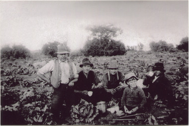
Photograph, Black & White, V Peterson E Boundary Rd E Bentleigh market garden c1925, Original c1925
... , parish of moorabbin, city of moorabbin, county of bourke... of Moorabbin County of Bourke after Henry Dendy's Special Survey ...The Peterson family were early settlers in Moorabbin Shire and established a market garden in East Boundary Road East Bentleigh. Vic Peterson - waistcoat, with Dick Marriott seated - ( brother in -law ), 2 unknown men and 7year old Geoff Peterson - Poliomyelitis as a baby- sitting in front with his walking sticks. The crop is cabbages that would be harvested and sent to the Melbourne markets.The early settlers like the Petersons and Marriotts, in the Parish of Moorabbin County of Bourke after Henry Dendy's Special Survey Brighton 1841, established market gardens, fruit & flower gardens, poultry & dairy farms, vineyards as well as shop businesses, blacksmiths, chemists, nursing homes and schools & Churches.Black & White photograph of Vic Peterson and 3 men & boy on his market garden in East Boundary Road East Bentleigh c1925 re-digitised 2005back ; handwritten information unsignedwagons, vulcan trucks, draught horses,, peterson vic, marriott dick, cabbage crops, vegetable crops, poliomyelitis epidemics 20thc , elster creek, plateways moorabbin shire, smith j l; smith mary ann, stanley helen, smith vic, smith harry redvers, chaff cutter, horse drawn carts, toll gates brighton, motor cars 1900, steam engines, early settlers, bentleigh, mckinnon, parish of moorabbin, city of moorabbin, county of bourke, moorabbin roads board, shire of moorabbin, henry dendy's special survey 1841, were j.b.; bent thomas, o'shannassy john, king richard, charman stephen, highett william, ormond francis, maynard dennis, market gardeners, vineyards, orchards -
 City of Moorabbin Historical Society (Operating the Box Cottage Museum)
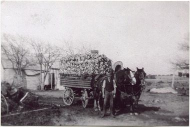
Photograph, Black & White, V Peterson East Boundary Rd East Bentleigh loaded wagon c1900, original c1900
... , parish of moorabbin, city of moorabbin, county of bourke... of moorabbin, county of bourke, moorabbin roads board, shire ...The Peterson family were early settlers in Moorabbin Shire and established a market garden in East Boundary Road East Bentleigh. Vic Peterson and family loaded the crop - cabbages - onto the horse drawn wagon and set off to the Melbourne market using the Plateways that ran along Centre Road and Nepean Highway. The early settlers like the Petersons , in the Parish of Moorabbin County of Bourke after Henry Dendy's Special Survey Brighton 1841, established market gardens, fruit & flower gardens, poultry & dairy farms, vineyards as well as shop businesses, blacksmiths, chemists, nursing homes and schools & Churches.Black & White photograph showing Vic Peterson beside the horse drawn wagon loaded with 35dozen ( 12x 35) cabbages setting off to market c 1900 Original re-digitised by H Stanley 2005Back Hand written informationwagons, vulcan trucks, draught horses,, peterson vic, marriott dick, cabbage crops, vegetable crops, poliomyelitis epidemics 20thc , elster creek, plateways moorabbin shire, smith j l; smith mary ann, stanley helen, smith vic, smith harry redvers, chaff cutter, horse drawn carts, toll gates brighton, motor cars 1900, steam engines, early settlers, bentleigh, mckinnon, parish of moorabbin, city of moorabbin, county of bourke, moorabbin roads board, shire of moorabbin, henry dendy's special survey 1841, were j.b.; bent thomas, o'shannassy john, king richard, charman stephen, highett william, ormond francis, maynard dennis, market gardeners, vineyards, orchards -
 City of Moorabbin Historical Society (Operating the Box Cottage Museum)
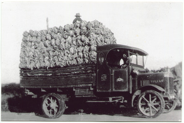
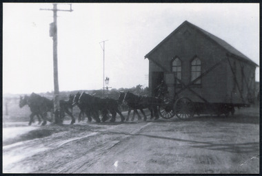
Photograph, Black & White, V Peterson, loaded Vulcan Truck 1929, c1929
... of moorabbin, county of bourke, moorabbin roads board, shire... of Moorabbin County of Bourke after Henry Dendy's Special Survey ...The Peterson family were early settlers in Moorabbin Shire and established a market garden in East Boundary Road East Bentleigh. Horse drawn wagons traveled along Plateways to take their crops to the Melbourne Markets . With the advent of the motorcar the market gardeners gradually purchased trucks to transport their crops. Roads were being surfaced but ruts and flooding caused upsets and bogging of these trucks. The journey was quicker but unlike the Horses, these trucks could not drive themselves back to the farm.The early settlers like the Petersons and Marriotts, in the Parish of Moorabbin County of Bourke after Henry Dendy's Special Survey Brighton 1841, established market gardens, fruit & flower gardens, poultry & dairy farms, vineyards as well as shop businesses, blacksmiths, chemists, nursing homes and schools & Churches.Black & White photograph of a Vulcan truck driven by Vic Peterson, loaded with Cauliflowers from his market garden in East boundary Road East Bentleigh c 1929.Back Handwritten information unsgnedwagons, vulcan trucks, draught horses,, peterson vic, marriott dick, cauliflower crops, vegetable crops, poliomyelitis epidemics 20thc , elster creek, plateways moorabbin shire, smith j l; smith mary ann, stanley helen, smith vic chaff cutter, horse drawn carts, toll gates brighton, motor cars 1900, steam engines, early settlers, bentleigh, mckinnon, parish of moorabbin, city of moorabbin, county of bourke, moorabbin roads board, shire of moorabbin, henry dendy's special survey 1841, were j.b.; bent thomas, o'shannassy john, king richard, charman stephen, highett william, ormond francis, maynard dennis, market gardeners, vineyards, orchards -
 City of Moorabbin Historical Society (Operating the Box Cottage Museum)
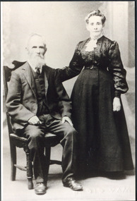
Photograph, Francis Box 1836 -1912 and Eliza Jane Box(Thompson) c1900, c1900
... , bentleigh, mckinnon, parish of moorabbin, city of moorabbin, county... and established market gardens in the parish of Moorabbin, County ...Francis Box 1836 1912 migrated, from Sussex England 1855, with his father George Box b1808, and joined his brother William Box in the Parish of Moorabbin . he established a market garden and with Eliza Jane Box raised his familyFrancis Box was a member of the pioneer family who migrated from Sussex England 1955 and established market gardens in the parish of Moorabbin, County of Bourke.Black & White photograph of Francis Box 1836-1912 who married Eliza Jane Box in 1871 box george b 1808, box francis 1836- 1912, box eliza jane , box william, box elizabeth, box cottage museum ormond, smith j l; smith mary ann, stanley helen, smith vic, early settlers, bentleigh, mckinnon, parish of moorabbin, city of moorabbin, county of bourke, moorabbin roads board, shire of moorabbin, henry dendy's special survey 1841, were j.b.; bent thomas, o'shannassy john, king richard, charman stephen, highett william, ormond francis, maynard dennis, market gardeners, vineyards, orchards -
 City of Moorabbin Historical Society (Operating the Box Cottage Museum)
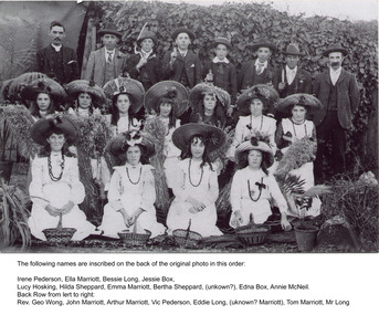
Photograph, Black & White,Methodist Youth 'Harvest Festival' East Bentleigh c1910, original c1910
... , mckinnon, parish of moorabbin, city of moorabbin, county of bourke... of moorabbin, county of bourke, moorabbin roads board, shire ...Early settlers established market gardens, farms and business in the East Brighton ( East Bentleigh) area of Henry Dendy's Special Survey 1841 Brighton. The small communities established Churches and Schools. Stephen Charman, 1821-1906 a market gardener, donated land for the first Methodist Chapel, Cemetery and School in Charman Rd Cheltenham 1855. The East Bentleigh settlers built a Methodist Church in Tucker Road and established the Sunday School and Youth group which organised social and sporting events and picnics.Early settlers established market gardens, farms and business in the East Brighton ( East Bentleigh) area of Henry Dendy's Special Survey 1841 Brighton. The small communities established Churches and Schools. Black and White photograph showing the Bentleigh Methodist Youth Group on Harvest Thanksgiving Sunday c1910 in front of R.Smith's shed in Tucker Road East Bentleigh re-digitised by H.Stanley CMHS 2005Back Handwritten Names on Original photograph Front row Irene Pederson, Ella Marriott, Bessie Long, Jessie Box, Lucy Hosking, Middle row Hilda Sheppard, Emma Marriott, Bertha Sheppard, ? , Edna Box, Annie McNeil Back row Rev. George Wong, John Marriott, Arthur Marriott, Vic Pederson, Eddie Long, ? Marriott,, Tom Marriott, Mr Long methodist youth group bentleigh c1910, marriott emma, marriott ella, hosking lucy, marriott john, box jessie, pederson vic, long bessie, wong george, shephard hilda, mcneil annie, smith j l; smith mary ann, stanley helen, smith vic, smith harry redvers, chaff cutter, horse drawn carts, toll gates brighton, motor cars 1900, steam engines, early settlers, bentleigh, mckinnon, parish of moorabbin, city of moorabbin, county of bourke, moorabbin roads board, shire of moorabbin, henry dendy's special survey 1841, were j.b.; bent thomas, o'shannassy john, king richard, charman stephen, highett william, ormond francis, maynard dennis, market gardeners, vineyards, orchards -
 City of Moorabbin Historical Society (Operating the Box Cottage Museum)
Newsletter, City of Moorabbin Historical Society Feb 2009, February 2009
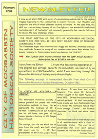
... county of bourke... brighton north road brighton county of bourke box h. box william ...The City of Moorabbin Historical Society was formed c 1960 by a group of Moorabbin residents who were concerned that the history of the area should be preserved. A good response to a call for items related to the historical area of Moorabbin Shire brought donations of a wide variety of artefacts which are now preserved by the current members of CMHS at Box Cottage Museum . Helen Stanley, Secretary of CMHS, began producing a Newsletter for members in April 2007 to provide current information and well researched items of historical interest.Helen Stanley has produced a bi-monthly Newsletter, 2007 - 2013, for the members of the City of Moorabbin Historical Society that contains well researched interesting historical items, notification of upcoming events, current advice from Royal Australian Historical Society , Museums Australia Victoria and activities of Local Historical Societies. The Newsletter is an important record of the activities of the CMHS. Tom Sheehy, past President of CMHS, was an Historian and Author of ‘Battlers Tamed the Sandbelt’. 2 x A4 paper printed on 3 sides Issue 10 of the bi-monthly, City of Moorabbin Historical Society Newsletter produced by Society member and Secretary, Mrs Helen Stanley in February 2009. The Victorian Bushfire tragedy around Marysville is still unfolding as this Newsletter is written. The first meeting for the year is February 22nd and subscriptions are due. An excerpt is transcribed from the City of Moorabbin Historical Society Newsletter October 1962, “A Piece of History in Ormond” by an unknown eyewitness author, describing the original “Box Cottage” situated in Mr J. Reitman’s cement products factory at 306 Jasper Road, Ormond prior to demolition. The current Editor gives information obtained from further recent research . An Article by Tom Sheehy, past President and Historian, February 1979 “The Vineyards of Moorabbin”. The ‘Brighton Estate” began when Henry Moor brought Vine cuttings from Camden NSW 1848 and they were productive after 3 years. Many Vineyards then appeared from Port Phillip Bay to East Boundary Road and produced 2/3 of the annual Victorian grape crop. Disease or insect caused failure in1858 and the land reverted to market gardens. A coloured photocopied photo of Box Cottage 2005. CITY of MOORABBIN HISTORICAL SOCIETY / FEBRUARY 2009 NEWSLETTERcity of moorabbin historical society, stanley helen, sheehy tom, melbourne, moorabbin, brighton, cheltenham, ormond, bentleigh, vineyards, fruit growing, vine diseases, winemaking, grapes, market gardeners, pioneers, early settlers, moorabbin shire, box cottage museum, dairy, port phillip bay, brighton estate, moor henry, cambden estate, reitman j., reitman w., cement, pottery, jasper road ormond, east boundary road brighton, dendy’s special survey 1851, point nepean road, south road brighton, thomas street brighton, north road brighton, county of bourke, box h., box william, bruton william, brighton brewery, parish of moorabbin, parish of prahran, markets, shingle roof, weather-board, downward mr., mckinnon -
 City of Moorabbin Historical Society (Operating the Box Cottage Museum)
Newsletter, City of Moorabbin Historical Society Apr 2009, April 2009
... county of bourke... brighton thomas street brighton north road brighton county ...The City of Moorabbin Historical Society was formed c 1960 by a group of Moorabbin residents who were concerned that the history of the area should be preserved. A good response to a call for items related to the historical area of Moorabbin Shire brought donations of a wide variety of artefacts which are now preserved by the current members of CMHS at Box Cottage Museum . Helen Stanley, Secretary of CMHS, began producing a Newsletter for members in April 2007 to provide current information and well researched items of historical interest.Helen Stanley has produced a bi-monthly Newsletter, 2007 - 2013, for the members of the City of Moorabbin Historical Society that contains well researched interesting historical items, notification of upcoming events, current advice from Royal Australian Historical Society , Museums Australia Victoria and activities of Local Historical Societies. The Newsletter is an important record of the activities of the CMHS.2 x A4 paper printed on 4 sides Issue 11 of the bi-monthly, City of Moorabbin Historical Society Newsletter produced by Society member and Secretary, Mrs Helen Stanley in April 2009. Notice that Mr Travis Sellars, Friends of Cheltenham and Regional Cemeteries, will talk about ‘The Tragic 20’s’ at the meeting April 26th . Volunteers are needed to show visitors around on Open Days each month and a Roster will be made on April 26th . Suggestions are requested for the Community Grant Application to be submitted by CMHS. Historical details are condensed from ‘ The Living Harvest’ by W.T Dobson, describing the establishment of St. Peter’s Catholic School East Bentleigh 1865 on land donated by Fred Quinn , in Centre Road, East Brighton ( East Bentleigh). A photo copy of Parts of Country Portion 39 of Dendy’s Special Survey or Brighton Estate showing the Land Sales of Lot 2, & 3 North Road and Jasper Road 1841 – 1869. Interesting note on the origin of ‘Jasper Road’. 3 photocopied photographs of St Peter’s School building 1903, School Children at East Brighton Railway Station, 1903, A Lorry in the parade 1903. CITY of MOORABBIN HISTORICAL SOCIETY / APRIL 2009 NEWSLETTERcity of moorabbin historical society, stanley helen, dobson w.t., melbourne, moorabbin, brighton, friends of cheltenham and reional cemeteries, cheltenham, ormond, bentleigh, market gardeners, irish immigrants c1850pioneers, early settlers, moorabbin shire, box cottage museum, port phillip bay, brighton estate, jasper road ormond, east boundary road brighton, dendy’s special survey 1851, point nepean road, south road brighton, thomas street brighton, north road brighton, county of bourke, box h., box william, parish of moorabbin, parish of prahran, markets, shingle roof, weather-board, mr., mckinnon, were jonathan, niall rev. fr. patrick, quinn fred, elsternwick, catholic church directory 1878, hibernian society melbourne, brady peter., kennedy mr., boland mr., leary mr., gahan mr., archbishop carr, rev. fr. gough., presentation convent gardenvale, sister mary vincent, charlston john, bavarian dress band, hales jasper -
 City of Moorabbin Historical Society (Operating the Box Cottage Museum)
Newsletter, City of Moorabbin Historical Society June 2009, June 2009
... county of bourke... north road brighton county of bourke box h. box william parish ...The City of Moorabbin Historical Society was formed c 1960 by a group of Moorabbin residents who were concerned that the history of the area should be preserved. A good response to a call for items related to the historical area of Moorabbin Shire brought donations of a wide variety of artefacts which are now preserved by the current members of CMHS at Box Cottage Museum . Helen Stanley, Secretary of CMHS, began producing a Newsletter for members in April 2007 to provide current information and well researched items of historical interest.Helen Stanley has produced a bi-monthly Newsletter, 2007 - 2013, for the members of the City of Moorabbin Historical Society that contains well researched interesting historical items, notification of upcoming events, current advice from Royal Australian Historical Society , Museums Australia Victoria and activities of Local Historical Societies. The Newsletter is an important record of the activities of the CMHS. Jasper Hale , transported for theft, earned his ‘Ticket of Leave, and purchased land in Dendy’s Special Survey of 1841 later known as East Bentleigh. 2 x A4 paper printed on 3 sides Issue 12 of the bi-monthly, City of Moorabbin Historical Society Newsletter produced by Society member and Secretary, Mrs Helen Stanley in June 2009. Notices of the meeting June 28th , an article in ‘The Leader’ newspaper about the Robert Keys ‘Best Fruit Garden 1881 - 82’ Trophy Cup , a large vinyl banner purchased with Grant money, and while acknowledging the Cottage garden volunteer a request for more helpers at Open Days is made. Jan Rigby, CMHS member, has provided research information about Jasper Hale b 1805 in Gloucester, England, transported to NSW 1830, ‘freed man ‘ 1839, purchased land in Dendy’s Special Survey 1844, sold this land 1846 and died 1884 in Parkes NSW. On arrival as a convict in 1830 his occupation is bricklayer and he can ‘ read and write’. CITY of MOORABBIN HISTORICAL SOCIETY / JUNE 2009 NEWSLETTERcity of moorabbin historical society, stanley helen, rigby jan, melbourne, moorabbin, brighton, cheltenham, ormond, bentleigh, market gardeners, pioneers, early settlers, moorabbin shire, box cottage museum, jasper road ormond, dendy’s special survey 1851, north road brighton, county of bourke, box h., box william, parish of moorabbin, were jonathan, hales jasper, port jackson penal colony, burgess s. william, kemble wiltshire england, stonemason, bricklayer, ‘york’ sailing ship, brummell mary, st. mary’s catholic church sydney, nelson mary ann, ‘george hibbert’ sailing ship, hale james, hale eliza, parkes new south wales gold rush, ballarat gold rush, clunes gold rush, forbes nsw gold rush, parkes historical society -
 City of Moorabbin Historical Society (Operating the Box Cottage Museum)
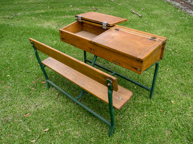
Education, 2 wooden 2 seat school desks c1950, c1950
... moorabbin, city of moorabbin, county of bourke, moorabbin roads... of moorabbin, county of bourke, moorabbin roads board, shire ...Typical wooden school desks used c 1950 in Victoria Typical of school desks used by pupils in schools in Victoria c 19502 (two) wooden school desks with ink wells and lift up writing lids for 2 children A) Is on an iron frame with a bench seat b) is on an iron frame with 2 separate seats education, schools, early settlers, bentleigh, parish of moorabbin, city of moorabbin, county of bourke, moorabbin roads board, shire of moorabbin, henry dendy's special survey 1841, were j.b.; bent thomas, o'shannassy john, king richard, charman stephen, highett william, ormond francis, maynard dennis, market gardeners, vineyards, orchards, state schools victoria, marriott c, whelan k, cochrane a, east bentleigh state school 2083, -
 City of Moorabbin Historical Society (Operating the Box Cottage Museum)
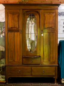
Furniture, Wardrobe 3 piece 3 drawers c1900, c1900
... , county of bourke, moorabbin roads board, parish of moorabbin..., city of moorabbin, county of bourke, moorabbin roads board ...The sections of this wardrobe can be lifted apart so that it can be transported easily and when assembled provides suitable hanging and storage space for the clothes and bed covers of an early settler family This wardrobe is of a type commonly used by early settler families in Moorabbin Shire c1900Wooden Wardrobe with 3 sections- top, hanging space with a central oval glass window, a shallow central drawer and 2 doors with key locks, and drawer section with 2 deep drawers early settlers, market gardeners, poultry farmers, mechanics institutes, furniture, kitchen equipment, clothing, drapery, haberdashery, green pederson carol, city of moorabbin, county of bourke, moorabbin roads board, parish of moorabbin, shire of moorabbin, henry dendy's special survey 1841, were j.b.; bent thomas, highett william, ormond francis, maynard dennis, -
 City of Moorabbin Historical Society (Operating the Box Cottage Museum)
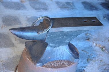
Tool - Blacksmith Anvil
... county of bourke... blacksmiths county of bourke Solid steel single horn shaped block used ...This anvil is typical of the type used by Blacksmiths in Moorabbin Shire c1850 - 20thC Blacksmith were needed to make machinery, tools, farm and household equipment, wheels and wagons, horseshoes and saddle irons.This anvil is an example of the type used by blacksmiths in Moorabbin Shire 1840- 20thC as early settlers developed the land. built homes, shops and schoolsSolid steel single horn shaped block used by a Blacksmith to make tools, horseshoes, kitchenware, farm equipment, wagon wheelsmarket gardeners, early settlers, moorabbin shire, dendy special survey 1841, bentleigh, moorabbin, cheltenham, tools, anvils, steel, horses, wagons, washing pots, cooking pots, blacksmiths, county of bourke -
 City of Moorabbin Historical Society (Operating the Box Cottage Museum)
Booklet - Church of St Matthew Cheltenham Souvenir Diamond Jubilee (of current building) 1867 - 1927, 1927
... county of bourke... county of bourke shire of moorabbin were j.b. market gardeners ...St Matthew's celebrated it Silver Jubilee in September 1927 with Church Services and social gatherings, a concert, a social and a dance. St Matthew's Church of England was erected in Cheltenham beside the Nepean Highway near Charman Road. The early settlers established a tennis club, cricket team and social groups.St Matthew's Church of England Cheltenham was erected in 1867 and was integral to the spiritual well being and social life of the early settlers.Souvenir booklet of text and pictures produced for the Diamond Jubilee for the St Matthew's Church of England, Cheltenham - 18 pagesst. matthew's church of england cheltenham, anglican church, early settlers, parish of moorabbin, city of moorabbin, county of bourke, shire of moorabbin, were j.b., market gardeners, cheltenham, charman road, nepean highway -
City of Moorabbin Historical Society (Operating the Box Cottage Museum)
Booklet - Eightieth Celebration of the Patronal Festival - St Matthew's Church Cheltenham - commemoration of the Dedication 1867-1947, 1947
... county of bourke... settlers parish of moorabbin city of moorabbin county of bourke ...St Matthew's Church of England was erected in Cheltenham beside the Nepean Highway near Charman Road. The early settlers established a tennis club, cricket team and social groups.St Matthew's Church of England Cheltenham was erected in 1867 and was integral to the spiritual well being and social life of the early settlers.Booklet on the history of St Matthew's Church, Cheltenhamst. matthew's church of england cheltenham, anglican church, early settlers, parish of moorabbin, city of moorabbin, county of bourke, shire of moorabbin, were j.b., market gardeners, cheltenham, charman road, nepean highway -
City of Moorabbin Historical Society (Operating the Box Cottage Museum)
Book - Pioneers of Faith - St Matthew's Cheltenham 1867 - 1992, by Sue Polites, 1992
... county of bourke... settlers parish of moorabbin city of moorabbin county of bourke ...St Matthew's Church of England was erected in Cheltenham beside the Nepean Highway near Charman Road. The early settlers established a tennis club, cricket team and social groups.St Matthew's Church of England Cheltenham was erected in 1867 and was integral to the spiritual well being and social life of the early settlers.Book about the history of St Matthew's Church, Cheltenham from 1867 to 1992. The book contains photos.st. matthew's church of england cheltenham, anglican church, early settlers, parish of moorabbin, city of moorabbin, county of bourke, shire of moorabbin, market gardeners, cheltenham, charman road, nepean highway -
City of Moorabbin Historical Society (Operating the Box Cottage Museum)
Book - A Journey of Faith - The Stained Glass Windows of St Paul's Bentleigh Holy Trinity Parish, by Patrick Ferry, 2015
... county of bourke... of the early settlers. city of moorabbin county of bourke shire ...St Paul's Church is in Jasper Road, Benlteigh. A foundation stone reads " This stone symbol of Christ, Chief corner stone of the church was blessed and set by His Grace Archbishop Simonds 13th November 1960, T O'Sullivan P.P. S. J. Morgan and Associates Architect H.P. Yunken Pty Ltd Builder". The stained glass windows were commissioned by Father Timothy O'Sullivan and the artist was Alan Sumner. The window were progressively installed from 1961, and took nearly 20 years to complete.St Paul's Catholic Church Bentleigh was integral to the spiritual well being and social life of the early settlers.A book about the stained glass windows in St Paul's Catholic Church in Jasper Road, Bentleigh - containing photos and diagram.city of moorabbin, county of bourke, shire of moorabbin, market gardeners, nepean highway, st paul's catholic church, bentleigh, jasper road, religion -
City of Moorabbin Historical Society (Operating the Box Cottage Museum)
Book - The Living Harvest - A history of St. Peter's Parish, East Bentleigh, by W. T. Dobson, 1974
... county of bourke... of moorabbin county of bourke shire of moorabbin market gardeners ...The first building that was erected in the Parish of St Peter's was a little wooden school house, built by local market gardeners in February 1865. The school was demolished and a brick school building was erected and opened in1903. St Peter's School, East Bentleigh was erected by the many Irish Market Gardeners of Moorrabin in 1865 and was integral to the education, spiritual well being and social life of the early settlers.A book on the history of St Peter's Parish, Centre Road, East Bentleigh, with pictures. 57 pages. Contains local history, history of early pioneer families, St Peter's School and the church.early settlers, parish of moorabbin, city of moorabbin, county of bourke, shire of moorabbin, market gardeners, center road, irish settlers, east bentleigh, st peter's church east bentleigh, religion, catholic -
City of Moorabbin Historical Society (Operating the Box Cottage Museum)
Pamphlet - St Finbar's Parish Church, East Brighton - Celebrating 150 Years 1848-1998, 1998
... county of bourke... parish of moorabbin city of moorabbin county of bourke shire ...St Finbar's Roman Catholic Church corner of Nepean Highway and Centre Road, East Brighton.St Finbar's Roman Catholic Church East Brighton was erected in 1871 and was integral to the spiritual well being and social life of the early settlers.Four page AO5 brochure inviting people to join in historic 150 year celebration. Contains brief history of the Parish of St Finger's East Brighton.early settlers, parish of moorabbin, city of moorabbin, county of bourke, shire of moorabbin, were j.b., market gardeners, nepean highway, east brighton, st finbar's parish, centre road, religion, roman catholic -
 City of Moorabbin Historical Society (Operating the Box Cottage Museum)
Document - Reflections - Bentleigh Baptist Church Diary
... county of bourke... parish of moorabbin city of moorabbin county of bourke shire ...The Baptist Church was built in 1881 in Tucker Road, in 1916 on land donated by Henry Box, a local market gardener. The wooden Church was moved to the to Vickery Street Bentleigh, the current site of the Bentleigh Baptist Church . The removal was made on a horse drawn jinker.The Baptist Church was integral to the spiritual well being and social life of the early settlers.22 Page typed document which outlines the history of the Baptist Church, Bentleigh.early settlers, parish of moorabbin, city of moorabbin, county of bourke, shire of moorabbin, market gardeners, baptist church bentleigh, vickery street, religion, bentleigh -
City of Moorabbin Historical Society (Operating the Box Cottage Museum)
Booklet - The Christ Church Chronicles 1900 -2001 - A presentation of Christ Church, Ormond's history for its Centennial celebrations, by Val Manson, 2001
... county of bourke... settlers parish of moorabbin city of moorabbin county of bourke ...Christ Church Ormond has been standing on the corner of North Road and Wheatley Road for over 100 years, but not always in its present form. Originally it was a weatherboard building built in 1901. Now called Ormond Anglican Church.Christ Church Ormond has served the community since 1900, was integral to the spiritual well being and social life of the early settlers.Typed document containing photos and diagrams - 74 pagesearly settlers, parish of moorabbin, city of moorabbin, county of bourke, shire of moorabbin, market gardeners, christ church ormond, ormond, north road, wheatley road -
City of Moorabbin Historical Society (Operating the Box Cottage Museum)
Document - Tenth Anniversary - Presbyterian Church East Bentleigh, 1957 - 1967, 1967
... county of bourke... of moorabbin county of bourke shire of moorabbin market gardeners ...Presbyterian Church East Bentleigh, built in 1957 in Cecil Street East Bentleigh. The site and building is now (2022) being used by Chabad, Bentleigh, which serves to cater to the needs of the Jewish Community.Presbyterian Church Bentleigh was formed to cater for the growing population of Bentleigh when the market gardens were subdivided into residential blocks.Document with blue cover, 18 pages. Contains text and pictures.parish of moorabbin, city of moorabbin, county of bourke, shire of moorabbin, market gardeners, presbyterian church east bentleigh, cecil street, east bentleigh, subdivision of land, religion -
City of Moorabbin Historical Society (Operating the Box Cottage Museum)
Booklet - Cheltenham Church of Christ - Our Heritage - The History of the Cheltenham Church of Christ, by K. G. Hilbig and G. L. Daff, 1970
... county of bourke... parish of moorabbin city of moorabbin county of bourke shire ...Cheltenham Church of Christ was opened in 1878 and is still in use today. Built on Chesterville Road, Cheltenham.Cheltenham Church of Christ was opened in 1878 and was integral to the spiritual well being and social life of the early settlers.Booklet 10 pages with typed textearly settlers, parish of moorabbin, city of moorabbin, county of bourke, shire of moorabbin, market gardeners, cheltenham, nepean highway, church of christ cheltenham, religion, chesterville road -
City of Moorabbin Historical Society (Operating the Box Cottage Museum)
Booklet - Souvenir History of the Church of Christ Cheltenham - 80th Anniversary May 2 & 3, 1937, by J. Ernest Allan, 1937
... county of bourke... parish of moorabbin city of moorabbin county of bourke shire ...Cheltenham Church of Christ was opened in 1878 and is still in use today. Built on Chesterville Road, Cheltenham.Cheltenham Church of Christ was opened in 1878 and was integral to the spiritual well being and social life of the early settlers.Booklet 19 pages with typed text and photosearly settlers, parish of moorabbin, city of moorabbin, county of bourke, shire of moorabbin, market gardeners, cheltenham, nepean highway, church of christ cheltenham, religion, chesterville road -
City of Moorabbin Historical Society (Operating the Box Cottage Museum)
Booklet - One Hundred Years - Church of Christ Chesterville Road, Cheltenham 1857-1957, by J. Ernest Allan, 1957
... county of bourke... parish of moorabbin city of moorabbin county of bourke shire ...Cheltenham Church of Christ was opened in 1878 and is still in use today. Built on Chesterville Road, Cheltenham.Cheltenham Church of Christ was opened in 1878 and was integral to the spiritual well being and social life of the early settlers.Booklet 12 pages with typed text and photosearly settlers, parish of moorabbin, city of moorabbin, county of bourke, shire of moorabbin, market gardeners, cheltenham, nepean highway, church of christ cheltenham, religion, chesterville road -
City of Moorabbin Historical Society (Operating the Box Cottage Museum)
Programme - Souvenir History of Centre Road, Bentleigh Methodist Sunday School 1850 -1954 Centenary Celebrations, 1954
... county of bourke... of moorabbin county of bourke shire of moorabbin market gardeners ...Methodist Sunday School, Centre Road was first held in 1854 and consisted of 52 scholars.The Methodist Sunday School in Centre Road, Bentleigh was integral to the spiritual well being and social life of the early settlers.Booklet of 25 pages with text and pictures.early settlers, parish of moorabbin, city of moorabbin, county of bourke, shire of moorabbin, market gardeners, centre road, methodist sunday school, bentleigh, religion -
 City of Moorabbin Historical Society (Operating the Box Cottage Museum)
Booklet - Souvenir History of Centre Road, Bentleigh Methodist Church Centenary Celebrations. 9 May - 17 May 1953, 1953
... county of bourke... settlers parish of moorabbin city of moorabbin county of bourke ...Methodist Church, Centre Road. The first church building on the site was built of timber in 1850. In 1865, the wooden church building was sold and a new brick church was built, this building was expanded over the years to accomodate an ever increasing congregation. In 1928 the parish opened yet another new brick church - which still stands today (2022). The church is now the Greek Orthodox Parish of "Saints Raphael, Nicholas & Irene".The Methodist Church in Centre Road, Bentleigh was integral to the spiritual well being and social life of the early settlers.Photocopy of Booklet of 9 pages with text and pictures.early settlers, parish of moorabbin, city of moorabbin, county of bourke, shire of moorabbin, market gardeners, centre road, methodist sunday school, bentleigh, religion -
City of Moorabbin Historical Society (Operating the Box Cottage Museum)
Booklet - A History of the Cheltenham Methodist Church, Charman Road 1854 - 1954, by Dr. K. A. Stephenson, 1954
... county of bourke... of moorabbin county of bourke shire of moorabbin market gardeners ...Cheltenham Methodist Church, history of the Methodist Congregation in Cheltenham and the building of their churches.Cheltenham Methodist Church was integral to the spiritual well being and social life of the early settlers.A booklet with 24 pages containing text and picturesearly settlers, parish of moorabbin, city of moorabbin, county of bourke, shire of moorabbin, market gardeners, cheltenham, charman road, nepean highway, methodist church, religion -
Whitehorse Historical Society Inc.
Document, Plan of Box Hill and district, 1890?
... County of Bourke... Mitcham melbourne Box Hill County of Bourke Plans Collins' plan ...Collins' plan of Box Hill and district.Collins' plan of Box Hill and district.Collins' plan of Box Hill and district.box hill, county of bourke, plans -
 Bayside Gallery - Bayside City Council Art & Heritage Collection
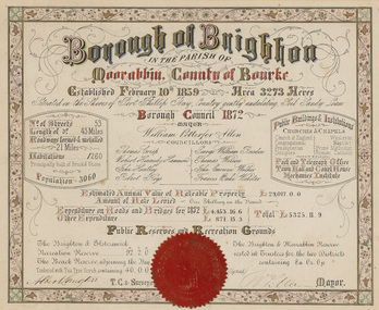
Certificate - Illuminated certificate, Brighton Municipal Certificate, 1872
... county of Bourke... Councillors Council borough county of Bourke Gives details ...bayside city council, borough of brighton, illuminated, certificate, population, rates, public buildings, wp allen, mayor, town clerk, surveyor, councillors, council, borough, county of bourke