Showing 3900 items
matching macedon
-
 Hume City Civic Collection
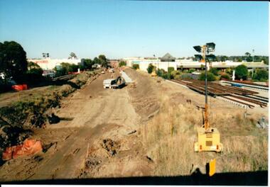
Photograph, 21/04/2005
This photograph was taken during the upgrade of the Bendigo Railway line at Sunbury Station. The upgrade of the line took over twelve months to complete and bus services replaced the train service during that time.A coloured photograph of construction on the site of the Sunbury Railway Station. The photograph has been taken from the Macedon Street bridge and is looking south towards Station Street. The old rail tracks have been removed and excavation work is in progress to make way for the new tracks. The new rail lines have been placed on the side of the track on the RHS of the photograph.railways, bendigo line, railway stations, bridges, sunbury railway station, george evans collection -
 Sunbury Family History and Heritage Society Inc.
Photograph
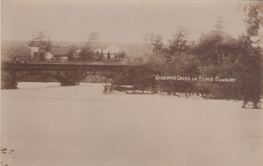
The post card is a record of a time when the Jacksons Creek flooded and the water almost reached the two arches on the Macedon Street Bridge. The Goonawarra Winery buildings can be seen in the back ground.A sepia photograph in post card format of a river in flood with the water almost reaching the two arches on the stone bridge. Farm buildings can be seen in the middle distance.JACKSON'S CREEK IN FLOOD SUNBURYmacedon street bridge, jacksons creek, goonawarra winery -
 Glen Eira Historical Society
Letter - Christian Family
Handwritten letter dated 17/07/1976 to Caulfield Historical Society from Keith Chappel, advising them that Thomas Christian of Mount Macedon is in no way related to Thomas Christian of Myoora, Caulfield.christian thomas, myoora, caulfield, chappel keith, house names -
 Hume City Civic Collection
Photograph, Early 1970s
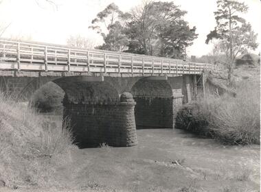
The Macedon Street Bridge over Jacksons Creek is important because it was built on one of Victoria's first important roads. It replaced a smaller lighter bridge in 1857 and continued to be used until the early 1970s.A black and white photograph of a two arched bluestone bridge over a creek. A wooden post and rail fence painted white has been constructed in front of the original stone wall of the bridge.bridges, bluestone bridges, jacksons creek, macedon street, george evans collection -
 Sunbury Family History and Heritage Society Inc.
Photograph, Bulla Primary School, Hanging Rock, 18th October 1995
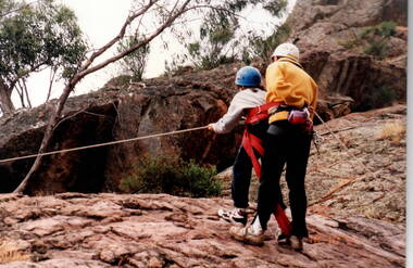
The older students were attending a school camp at Hanging Rock in the Macedon Ranges area in 1995 and one of the activities the children were introduced to was rock climbing as the formation offers many sites for this activity.A non-digital coloured photograph of a supervisor instructing a girl who is attempting to do rock climbing. They are doing the activity on a natural rocky plateau.school camps, hanging rock, rock climbing, bulla primary school -
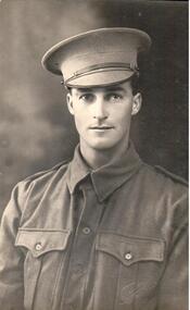 Hume City Civic Collection
Photograph
From the information on the back, the soldier in the photograph has been identified as Dr. Falkiner's son. Dr. Falkiner was a doctor who practised medicine in Sunbury. He built "Ardcloney" mansion in Macedon Street, Sunbury.A black and white photograph of a soldier from the waist up identified only as Doc Falkiner's son. Unmounted.written on back: Doc Falkiner's sonsoldiers, armed forces, uniforms, portraits, falkiner, - (dr), talma, photographers, clothing and dress, george evans collection -
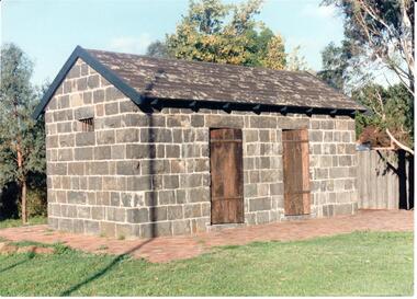 Hume City Civic Collection
Photograph
The Aitken Gap Gaol was originally constructed at the Gap Settlement on the Calder Highway in 1857 for the gold escorts. It was relocated to its present site outside the Sunbury Police Station in Macedon Street between 1989 and 1991.A coloured photograph of the relocated Aitken Gap Gaol. It has bluestone walls and a moss covered slate roof. with 2 solid stained wooden doors and blue painted wooden trims. A small cell window is on the side of the building and a paved brick area surrounds the gaol.aitken gap gaol, gap village, sunbury police station, george evans collection -
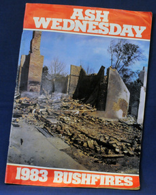 Orbost & District Historical Society
newsaper/magazine, Ash Wednesday, February 1983
This magazine was published to raise money for the State Disaster appeal. It was a tribute to the photographers and reporters who contributed to the coverage of the Ash Wednesday bushfires for these publications.this item is a contemporary record of a major fire disaster in Victoria and is a useful reference tool.A large 78 pp stapled magazine. On the front cover is a coloured photograph of the town of Macedon the morning after the bush fires in February 1983. It has white ASH WEDNESDAY in print on a red background above the photograph and 1983 BUSHFIRES in white print on a red background belop the photograph. The photograph extends to the back cover. The magazine contains black/white photographs, stories and reports.bushfires ash-wednesday magazine disasters-victoria -
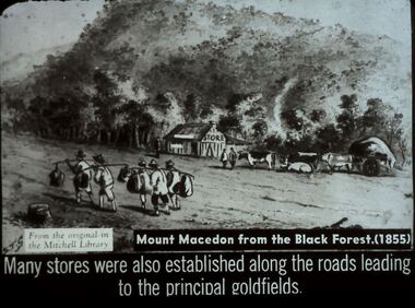 Bendigo Historical Society Inc.
Slide - DIGGERS & MINING. STORES AT THE DIGGINGS, c1855
Diggers & Mining. Stores at the diggings. STG From the original in the Mitchell Library. Mount Macedon from the Black Forest. (1855) Many stores were also established along the roads leading to the principal goldfields. Slide depicts at group of Chinese passing by a store in the Black Forest o the way to the diggings. Markings: 35 994.LIF. 5. Used as a teaching aid.hanimounteducation, tertiary, goldfields -
 Sunbury Family History and Heritage Society Inc.
Photograph, c1940s
The people in the photograph are outside the Sir John Franklin Hotel which was one of the first hotels to be established in Sunbury in the early days of European settlement along Macedon Street. It continued to operate into the first half of the twentieth century.A non-digital black and white photograph with a cream border. of twenty two people and a dog standing and sitting outside a hotel building.sir john franklin hotel, hotels, sunbury -
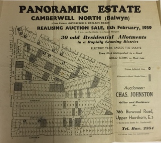 Kew Historical Society Inc
Plan - Subdivision Plan, Panoramic Estate, Camberwell North (Balwyn), 1939, 1939
Subdivision plan advertised as the Panoramic Estate, Balwyn, showing lots for sale in the following streets: Bulleen Road, Macedon Avenue, The Moor, Sunburst Avenue, Doncaster Road, Fortuna Avenue, Longview Road, The Nook, and Touring Avenue.Single page subdivision plan of the Panoramic Estate in Camberwell North (Balwyn); offered for sale in 1939Nilsubdivision plans - balwyn (vic), panoramic estate - camberwell north - balwyn (vic) -
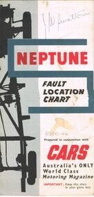 Bendigo Historical Society Inc.
Map - J W SWATTON COLLECTION: MAPS
Seven maps of various sizes. Map of the City of Ballarat, Victoria, Road Condition Map of Victoria including Melbourne-Cairns & Melbourne-Adelaide, Neptune Fault Location Chart, Grampians District Map, Racv Tour Planning Map Showing Road Conditions for Victoria, NSW and Queensland and Mt Macedon & District. Two of the maps have J W swatton & J Swatton written on them.j w swatton collection, racv, mobil, neptune, a r blair, j ewins & sons pty ltd, berry anderson & co -
 Hume City Civic Collection
Photograph - Evans Street, Sunbury, c1880 - 1900s
The photograph shows a picture of Evans Street Sunbury taken from the T intersection at Macedon Street and looking south. When the photograph was taken it was one of Sunbury's main residential areas. Since the 1980s the houses in the image have been demolished and replaced with commercial development.- Over the years Evans Street has undergone much change from being a residential strip to being the main commercial hub in Sunbury.– An enlarged photograph of a streetscape with a row of trees growing along the footpath and a number of weatherboard Victorian style double fronted cottages. Both the roadway and footpath are not surfaced and the gutter is lined with stone pavers.sunbury -
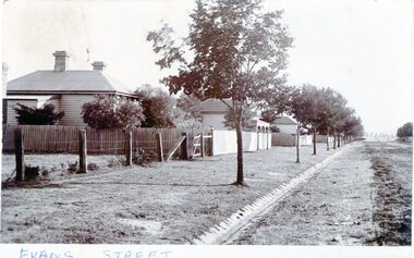 Sunbury Family History and Heritage Society Inc.
Photograph - Evans Street, Sunbury, c1900s
The photograph shows a picture of Evans Street Sunbury taken from the T intersection at Macedon Street and looking south. When the photograph was taken it was one of Sunbury's main residential areas. Since the 1980s the houses in the image have been demolished and replaced with commercial development. Over the years Evans Street has undergone much change from being a residential strip to being the main commercial hub in Sunbury.A sepia photograph with a white border across the bottom and in post card format of a streetscape with a row of trees growing along the footpath and a number of weatherboard Victorian style double fronted cottages. Both the roadway and footpath are not surfaced and the gutter is lined with stone pavers.EVANS STREETevans street -
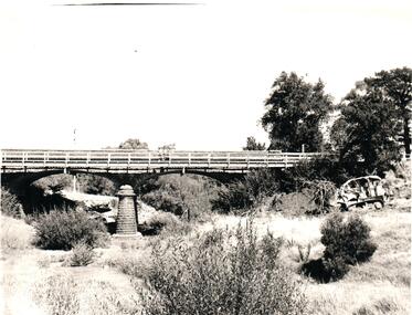 Hume City Civic Collection
Photograph, 1960s
The two-arched bluestone bridge which spans the Jacksons Creek at the east end of Sunbury township, was built in 1857 and continued to be used as a road bridge on the main Sunbury Road-Macedon Street until the early 1970s when a wider bridge replaced the original bluestone bridge.A black and white photograph of a two- arched bluestone bridge which spans a dry creek bed. A bulldozer is on the riverbank on the RHS of the photograph.bridges, bluestone bridges, jacksons creek, harris, thomas lascelles, macedon street, george evans collection -
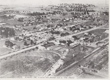 Sunbury Family History and Heritage Society Inc.
Photograph, 1936
The aerial view of Sunbury was featured in The Argus newspaper in 1936 in recognition of 100 years of European settlement of the area. It shows the extent of the township in 1936 which extended from the railway line in the west to the Jackson Creek in the east and the Sunbury Asylum in the south and northwards towards Macedon Street. The photograph was taken when Sunbury was a country settlement 25 miles ( 37 kms) from Melbourne. Since the 1980s the area grown rapidly and is now an outer suburb of Melbourne.A black and white aerial photograph with a cream border of the Sunbury township. SUNBURY 1936 - A SOUVENIR AERIAL PHOTOGRAPH ISSUED BY THE ARGUS.aerial photographs -
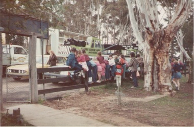 Sunbury Family History and Heritage Society Inc.
Photograph, Bulla Primary School, 1984
Portable classrooms being brought into a school was how many schools accommodated children when there was an increase in student enrolments and there were insufficient classrooms available at a school. This portable room was transported from Macedon Primary School in September 1984 and it became known as Room 1 at Bulla. The use of portable classrooms was widespread across Victoria especially from 1945 to the end of last century.A non-digital coloured photograph with school children sitting and standing on a fence watching a portable classroom being transported to their school. bulla primary school, bulla, schools, portable classrooms -
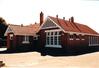 Hume City Civic Collection
Photograph, early 1990s
The brick building was constructed in 1911/1912 and replaced an earlier school building. In 1942/43 the school building was extended to cope with the increased population in Sunbury. The State School remained on the Macedon Street site until 1999 when it was relocated to the restored former Industrial School at Jacksons Hill.A coloured photograph of the former Sunbury State School No. 1002. It is a red brick Federation building with a red terracotta tiled roof and wooden white painted trims. There are two stepped brick chimneys with terracotta chimney pots and six air vents protruding from the roof. There is a small porch at the front of the building.carirns, j. f. dr., eadie, peter, education department, george evans collection -
 Hume City Civic Collection
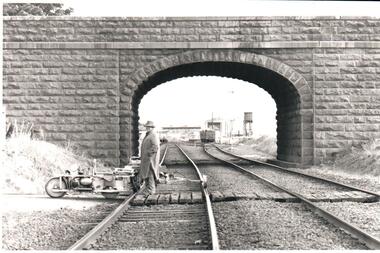
Photograph, Pre 1989
The bluestone 'road over rail' bridge at Macedon Street is of state architectural, architectural, historical and engineering significance. It spans the first government regional railway. Its design and building was done according to strict English standards and made use of a bridge crossing instead of a level road crossing.A black and white photograph of a stone bridge with an eliptical arch spanning two rail tracks. A workman is standing between one set of tracks in the foreground and a railcart is next to the tracks. The station, footbridge and water tower are visible through the arch.road over rail bridge, bridges, sunbury railway station, water towers, pedestrian bridges, stone bridges, george evans collection -
 Sunbury Family History and Heritage Society Inc.
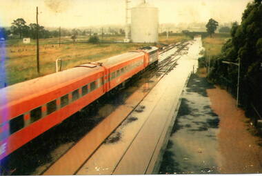
Photograph, 17 December 1985
On 17th December 1985 record torrential rain fell in Sunbury, which flooded the main Melbourne Bendigo rail line and disrupted traffic. The photograph is looking to the north of the station and takes in the historic Macedon Street bridge and the open ground with the storage silo on the west side of the railway line. A coloured photograph of a former V Line train stopped at a station where the railway line has been flooded. A storage silo occupies vac ant ground adjacent to the railway line.sunbury railway station, storage silos, horne street -
 Sunbury Family History and Heritage Society Inc.
Photograph, 25th July 1986
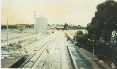
Heavy snow fell across Melbourne and surrounding suburbs, including Sunbury, on 25th July 1985. The photograph taken from the pedestrian bridge at Sunbury Railway Station is looking north to the historic Macedon Street bridge. The widespread snow across the metropolitan area on that day caused much chaos.A coloured photograph of widespread snow across a railway line and the surrounding area.sunbury railway station, extreme weather events, snow storms -
 Sunbury Family History and Heritage Society Inc.
Photograph, 13 Evans Street, Sunbury
The cottage in the photograph was situated at 13 Evans Street in Sunbury and was one of the last houses to be demolished along the business of Evans Street between Brook and Macedon Streets. The cream brick building on the RHS of the house is a Telstra complex. The cottage was demolished in the early 2000s and a fast-food outlet now occupies the site. The cottage was one of a group of small attractive buildings erected along the northern end of Evans Street in the second half of the nineteenth century.A non-digital coloured photograph of a small double fronted Victorian cottage with a slate roof and a verandah across the front of the house. A cream brick structure with a signal tower is on the RHS of the photograph and a large bare elm tree is growing on the nature-strip. 13 evans street, victorian cottages, evans street, telstra -
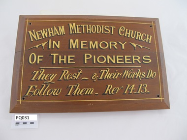 Uniting Church Archives - Synod of Victoria
Plaque
Newham is a rural village 8 km north-east of Woodend and 65 km north-east of Melbourne. It is to the north of the Mount Macedon range. It was named after the Newham pastoral run (1848), which is thought to have been named after the birthplace of the run’s proprietor, Edward Dryden, Newham, England. [Source:https://www.victorianplaces.com.au/newhamOblong stained wood plaque with black and guilt text. There is a hole drilled in each corner."NEWHAM METHODIST CHURCH IN MEMORY OF THE PIONEERS. They Rest & Their Works Do Follow Them Rev 14-13"newham methodist church -
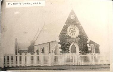 Hume City Civic Collection
Photograph
St. Marys Catholic Church is now known as Our Lady of Mt. Carmel in Macedon Street, Sunbury. From information written on the back of the photograph it was believed to be the Presbyterian Church Bulla. This being the case, it was relocated because of the construction of the International Airport. Sir Henry Winneke probably re-opened the Bulla Church on 24 November 1975.A black and white photograph of a blustone church behind a picket fence known as St. Marys Catholic Church Sunbury but has been incorrectly labelled as St. Marys Catholic Church Bulla.top LH corner on piece of paper pasted and type written : St. Marys Church Bullast mary's catholic church, our lady of mt carmel church, churches, sunbury, bulla, macedon street, winneke, henry (sir), 1970s, george evans collection -
Hume City Civic Collection
Certificate
This unused Certificate of Appreciation was the same as certificates that the committee of The Old Sunbury Court House presented to workers or volunteers for the help in the restoration of the Court House. The former Court of Petty Sessions in Macedon Street, Sunbury once it was no longer used for that purpose was then renovated and became the Visitor Information Centre used by tourists and locals to access information of the area and beyond.This is an unused Certificate of Appreciation of the Old Sunbury Court House Committee.court of petty sessions, sunbury court of petty sessions, visitor information centre, old sunbury courthouse -
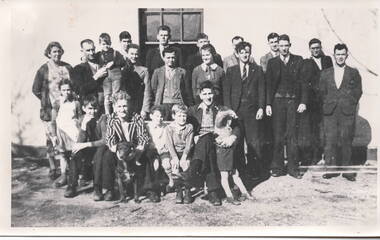
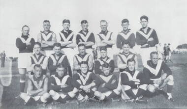 Sunbury Family History and Heritage Society Inc.
Photograph, Sunbury Football team, C 1930s - 1940s
Th members of the Sunbury Football team were photographed in the former sports ground that was on railway land bounded by Evans and Macedon Streets and the railway land. For many years that site was known as Sunbury's sports ground until 1949, when crown land facing Riddell Road was developed as a recreation and sport's ground and became known as Clarke Oval.Sport has played a prominent role in Sunbury and district's social life since the mid nineteenth century.A non-digital of a copied and enlarged black and white photograph of a team of football players standing and sitting in three rows in a sports ground. sunbury football club, "the swifts', sports clubs, football, australian rules football -
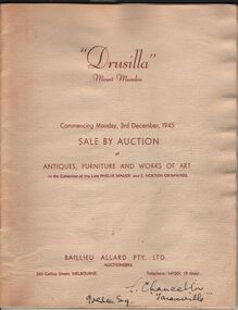 Bendigo Historical Society Inc.
Document - LYDIA CHANCELLOR COLLECTION; 'DRUSILLA' MOUNT MACEDON
A catalogue titled 'Drusilla' Mount Macedon. 'Commencing Monday, 3rd December, 1945 Sale By Auction of Antiques, Furniture and Works of Art. In the Collection of the late Phelia Maude and E. Norton Grimwade. Baillieu Allard PTY. LTD. Auctioneers. 360 Collins Street, Melbourne. Telephone: M1001 (9 lines.)' Also included in the catalogue is a newspaper cutting dated 2/3/1946 and titled 'Charming Debutantes.' The two debutantes are Judith Barrett and Phelia Grimwade the daughters of Mrs. Russell Barrett and Mrs. Lionel Grimwade.buildings, house, drusilla, lydia chancellor collection, collection, 'drusilla, ' mount macedon, place, house, home, auction, antiques, furniture, art, artwork, auctioneers, debutantes, judith barrett, phelia grimwade, mrs. russell barrett, mrs lionel grimwade, history, heritage -
Kew Historical Society Inc
Plan - Camberwell Panorama Estate, 1923
Subdivision plans and real estate flyers/brochures reveal a number of aspects of urban development and history. The Kew Historical Society's collection of these plans, as well as advertisements extracted from magazines, cover key aspects of community development and architectural history of Kew and Kew Eat as well as surrounding suburbs. While most of the plans in the collection were gifted to the Society by the former City of Kew, a number of other plans and advertisements have been donated by individuals, of which this is an example.Promotional brochure for the Camberwell Panorama Estate. The four page bifold handout advertises 216 home sites bounded by Bulleen Road, The Nook, Fortuna Avenue, and Doncaster Road. Other streets in the subdivision include: Sunburst Avenue, The Moor, and Macedon Avenue. The brochure has been damaged at some time in the past and so masking tape obscures the tram on page 1. Page 2 includes the plan of the subdivision, page 3 information about the site and a locality plan, while page 4 includes photographs and terms of sale. subdivision plans -- balwyn north (vic.), camberwell panorama estate -
 Sunbury Family History and Heritage Society Inc.
Photograph, c 1940s
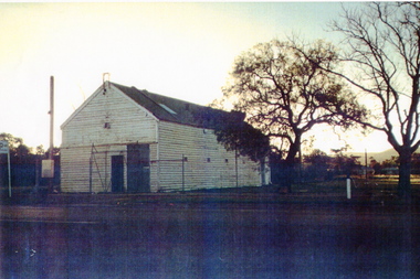
The building was the former Sunbury Fire Station. It was in Evans Street on the site where the shopping square has been built. Mount Holden can be seen in the background. A newer building was built for the CFA on the opposite side of Evans Street and closer to Macedon Street. As the shopping centre expanded and Sunbury grew, the CFA moved from the town centre to a site in Jackson Street and another one in Elizabeth Drive.Over the years the CFA has played an important role in numerous fire fighting activities over summer months.A scanned coloured photograph with a fine white border of an old weatherboard building with a metal roof by an unmade roadway. A hill is in the background and two bare trees are growing near the building.sunbury cfa. -
Hume City Civic Collection
Photograph, Former Shire of Bulla offices, 1970s
The building in the photograph is the former Shire of Bulla offices in the Bulla township. They were built in 1867 and the first meeting took place in the new building on 27th November 1867. Regular council meetings took place there until 1901 when some council meetings were held in the Mechanics Institute (now the Memorial Hall) in Sunbury. In 1963 permanent Shire Offices were built in Macedon Street in Sunbury. A non-digital coloured photograph with rounded corners of a double-fronted bluestone build with a slate roofing and a post and rail fence across the front of the property.