Showing 811 items
matching maps and sections
-
 Falls Creek Historical Society
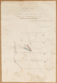
Plan - Leases of part of Falls Creek Tourist Area
Bob (Herman) Hymans (a former member of the Royal Netherlands Navy was born in Bloemendaal, Holland on 30th September 1922. During World War II he fought against the Japanese in the Dutch East Indies (now Indonesia) and was imprisoned in Changi and on the Burma Railway. After gaining qualifications as a Ski Instructor, Bob arrived in Falls Creek in May 1950. Working as an Instructor and Supervisor at Bogong Lodge, Bob decided his future was in accommodation. He was successful in negotiating an indenture for land from the State Electricity Commission (SEC). It took Bob two years to build his Grande Coeur Chalet but, tragically, it was burned down in August 1961. Bob also built the first Chairlift in Australia. This was a single chairlift and the structure was built from wooden electricity poles. He was constantly full of new ideas and proposals for the village. Bob Hymans died on 7th May 2007. This Collection of documents and letters tells the story of Bob’s endeavours to develop Falls Creek into the ski village it is today. This map is significant because it documents boundaries of early leases in Falls Creek Tourist Area.This map is part of Bob Hymans documents. It is a large Surveyor's Plan of a section of the Falls Creek Tourist Area. It is endorsed by J Parker, Chief Surveyor of the State Electricity Commission of Victoria on 27-3-84. It shows streets, lot numbers and measurements. It was a compilation created from existing lease maps. Heading - PART OF FALLS CREEK TOURIST AREA PART OF CROWN ALLOTMENT 1 PARISH OF CARRUNO PART OF CROWN ALLOTMENT 1 PARISH OF DARBALANG COUNTY OF BOGONGmap of falls creek, falls creek leases, falls creek 1980s -
 Bacchus Marsh & District Historical Society
Map, Rough plan showing proposed deviation of road through McKenzie's Flat
The date of this map or plan is uncertain. McKenzie's Flat is a bushland picnic area on the Lerderderg River in the Lerderderg State Park close to Bacchus Marsh. Single page map showing a proposed deviation of the road near the McKenzie's Flat area close to Bacchus Marsh. The proposed deviation is shaded in pink, The existing road section to be replaced is shaded in blue. No scale is indicated. Part of a set of maps which are pasted into a bound volume containing 76 maps or plans in total. High resolution digital image stored on BMDHS computer network. mckenzies flat bacchus marsh, bacchus marsh roads and streets -
 Bendigo Military Museum
Administrative record - International Map of the World (IMW) 1:1 Million Scale - H Ureta, Circa 1964, MR H Ereta, Post 1964
This document records the history of the International Map of the World (IMW) at 1:1Million Scale. Mr H. Ereta, Chief of the Cartographic Section of the United Nations Department of Economic Development and Social Affairs gave a lecture on the IMW and described the history and development of the map series in post 1964. This document is a copy of that lecture. 7 x Foolscap pages of typed text, stapled and two hole punched, Paper is dis-coloured.royal australian survey corps, rasvy, fortuna, army survey regiment, army svy regt, asr, imw -
 Lara RSL Sub Branch
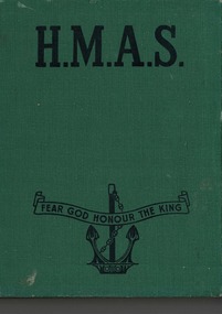
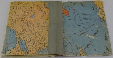
Book, H.M.A.S, 1953
HMAS illustrates the Royal Australian Navy who have not only by their action afloat given us the basic material for a record of achievement, but who have, in their written and artistic contributions made this book a really worthwhile thing over their three years of naval warfare.Historical recounts of HMAS Naval serviceGreen hardcover front, back and spine with black text of title, motto and insignia on front cover. Photographs, maps, sketches, cartoons, pictograph. A section which lists awards to Australian Naval Personnel. royal australian navy, h.m.a.s, h.m.a.s. sydney, h.m.a.s. voyager, h.m.a.s. vampire, h.m.a.s. hobart, h.m.a.s perth, h.m.a.s vendetta, h.m.a.s waterhen, h.m.a.s stuart, mediterranean, malta, gibralter, bab-el-mandeb, libya, arabian sea -
 Federation University Historical Collection
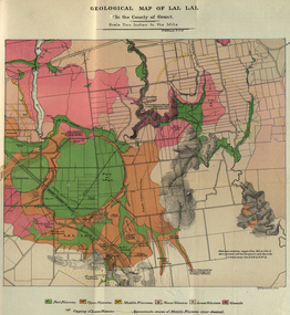
Booklet, The School of Mines Ballaarat Annual Report 1883, 1883
The School of Mines Ballaarat. Annual Report 1883. Statement of Receipts and expenditure, general balance sheet, and list of subscriptions donations 1883. Annual Report, Balance Sheet, Certificates granted by the Council, Examination Papers - Elementary Science Classes (Appendix), Fees, Honorary Correspondents. Life Governors, Museum - open to visitors, Office Bearers, Paper of Particulars, Report of the Curator of the Museum and Library, Report of the Superintendent of Laboratories, Report of the Lecturer in Mathematics, Report of the Lecturer in Mechanical Engineering, Report of the Lecturer in Telegraphy, Report of the Lecturer in Materia Medica, Report of the Lecturer of Astronomy, Scale of Charges for Assays and Analyses, Examinations Held, Statement of Receipts and Expenditure for the year 1883, Subjects and Lectures, Subjects and Examiners, Subscriptions and Donations, from 1st January to 31st December 1883.Ballaarat School of Mines annual Report. Soft cover pale green booklet of 67 pages. Includes a colour Geological Map of Lal Lal and a sketch Section from Lal Lal to the Moorabool. Inscription on front cover 'Office Copy' On pages 4 and 5 some names have been crossed out and others added.ballarat school of mines, annual report, balance sheet, certificates granted by the council, examination papers, fees, honorary correspondents, life governors, museum, office bearers, paper of particulars, ballarat school of mines museum, library, superintendent of laboratories, mathematics, mechanical engineering, telegraphy, lecturer in materia medica, statement of receipts and expenditure for the year 1882, examiners, subcriptions and donations, alfred mica smith, chemistry, metallurgy, f.m. krause, ferdinand krause, geology, mineralogy, scientific mining, t.h. thompson, practical mining, w.h. shaw, h. reid, mechanical enginnering, phoenix foundry company (limited), phoenix foundry, arthur. a. buley, mining, engineering surveying, walter. d. campbell, j. wall, astronomy, james oddie, natural philosophy, elementary mechanics and hydrostatics, magnetism and electricty, sound, light and heat, j.f. usher, materia medica, pharmacy, physiology, w.h. shawmechanical engineering, h.m. andrew, h.d. de la poer wall, thomas mann, p.c. fitzpatrick, h. rosale, john lewis, w.c. kernot, mccoy, j. cosmo newbery, baron von mueller, samuel w. macgowan, w.p. bechervaise, r.l.j. ellery, astronomer, j.m. bickett, james bickett, n. kent, a. martin, r.s. mitchell, w.h. keast, p. matthews, d. milliken, j.t. richards, jonathan robinson, h. brookes allen, joseph bosisto, c.r. blackett, m.l.a., william. johnson, government of victoria analyst, moorabool, lal lal, skipton, coal, skipton coal discovery, lal lal creek, moorabool falls, lal lal race course, lal lal falls, moorabool river, william h. keast -
 Tatura Irrigation & Wartime Camps Museum
Book, Oswald Volkmann, Under Consideration, 1941
Booklet of poems in two languages by Dunera internee Oswald Volkmann, No.35271, at Camp 4, Tatura.Soft cover handmade/compiled book of typed poems. Covers feature maps (military). Inside front and back cover features sections of cartoons. Housed in a light green cardboard conservation box.Tatura 28 Okt 1941oswald volkmann, camp 4, internees, poetry -
 Whitehorse Historical Society Inc.
Map, Ringwood, c1922
... Maps ...Victoria Ringwood Survey map 1 inch to 1 mile.Victoria Ringwood Survey map 1 inch to 1 mile. Covers Eastern suburbs of Melbourne from Richmond to Macclesfield, Heidelberg / Lilydale to Dandenong. Prepared by Commonwealth Section, Imperial General Staff.Victoria Ringwood Survey map 1 inch to 1 mile. eastern suburbs, melbourne, maps -
Whitehorse Historical Society Inc.
Map, Melbourne and suburbs, 1923
Section of map 'Melbourne and Suburbs' compiled at the Department of Lands and Survey, Melbourne by E. S. Hilcke, March 1923, reprinted 1940.Section of map 'Melbourne and Suburbs' compiled at the Department of Lands and Survey, Melbourne by E. S. Hilcke, March 1923, reprinted 1940. Scale 40 chains: 1 inch. - Shire of Blackburn and MitchamSection of map 'Melbourne and Suburbs' compiled at the Department of Lands and Survey, Melbourne by E. S. Hilcke, March 1923, reprinted 1940.department of lands and surve, melbourne and suburbs -
 Bendigo Military Museum
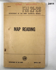
Manual - MAP READING, Department of Army, C. 1956
Soft cover, brown manual, Map Reading, RM21-26 Department of Army Technical Manual March 1956. 216 pages with fold out sections, photos, sketches, graphs & technical data.“12843 WILLIAMS”books - manuals, military, map reading -
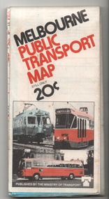
 Melbourne Tram Museum
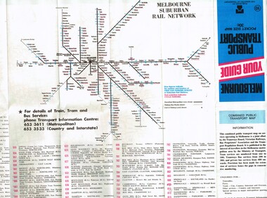
Map, Ministry of Transport, "Melbourne Transport Services Map - Tram, Train and Bus Services", c1975
Fold out map (27 sections 9 across x 3 deep), coloured of Melbourne's Tram and Bus routes, route numbers, rail lines, detailed for the central part of Melbourne and insert section for Frankston. On rear description of routes, private bus routes and map of Melbourne metro lines. Has contact details for bookings and lost property etc. Not priced. Not dated, but circa 1975 - has map scale in kms and route 59 to Essendon Airport still extends into Airport. 2nd copy added 16/7/2014. See Reg Item 521 for issue No.. 2, 1974.On front cover in ink "issue #3" in top right hand corner and "4 G 33" along bottom edge.trams, tramways, melbourne, map, tram & bus services, railways, mmtb, minister for transport -
 Lara RSL Sub Branch
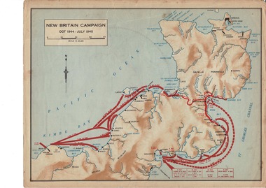
Map, World War 2 Borneo Area, 1945
Military maps of Australian Campaigns in the Borneo area World War 2paper coloured maps from unknown bookMap 1 Centre section opened - North Borneo Campaign June - July 1945. Closed Side 1 - Tarakan Campaign 1 May - 21 June 1945. Side 2 Balikpapan Campaign July 1945 Map 2 Centre section opened - Aitape-Wewak Campaign Nov 1944 - Aug 1945. Closed Side 1 Bougainville Campaign Nov 1944 - June 1945 New Britain Campaign Oct 1944 - July 1945borneo new britain bougainville wewak maps ww2 -
 Melbourne Tram Museum
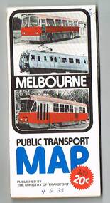
Map, Ministry of Transport, "Melbourne Your guide public transport", 1980
Fold out map (27 sections 9 across x 3 deep), coloured of Melbourne's Tram and Bus routes, route numbers, rail lines, detailed for the central part of Melbourne and insert section for Frankston. On rear description of routes, private bus routes and map of Melbourne metro lines. Has contact details for bookings and lost property etc. Priced 30c No. 11 Dated 1980 on rear .1 - 1 as above, blue cover, No. 10, also dated 1980.trams, tramways, melbourne, map, tram & bus services, railways, mmtb, minister for transport -
 Melbourne Tram Museum
Document - Report, Melbourne & Metropolitan Tramways Board (MMTB), "Section to Section trips compiled from information obtained by the Melbourne Metropolitan Transportation Study 1964 Card survey.", Mar. 1967
... Maps ...Report - Foolscap landscape format, red tape binding - approx. 30 pages with notes, diagrams, charts, maps showing passenger traffic for parts of each route. Titled "Section to Section trips compiled from information obtained by the Melbourne Metropolitan Transportation Study 1964 Card survey from tram and bus routes based on the Central Business area of Melbourne". Dated 3/1967. Contains a large fold out map of each route showing passenger numbers for the day.In top right hand corner "Lees" in inktrams, tramways, mmtb, tramways, melbourne, surveys, passengers, maps -
 Melbourne Tram Museum
Map, Ministry of Transport, "Melbourne Transport Services Map - Tram, Train and Bus Services", 1976
Fold out map (27 sections 9 across x 3 deep), coloured of Melbourne's Tram and Bus routes, route numbers, rail lines, detailed for the central part of Melbourne and insert section for Frankston. On rear description of routes, private bus routes and map of Melbourne metro lines. Has contact details for bookings and lost property etc. Priced 20c Has a bus, silver train and a Z class tram on the cover. On bottom of outside cover, "No. 5 1976"On front cover in ink "5" in top right hand corner and "4 G 33 " along bottom edge.trams, tramways, melbourne, map, tram & bus services, railways, mmtb, minister for transport -
 Bendigo Historical Society Inc.
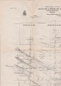
Map - HUSTLER'S LINE OF REEFS, September 1913
Map, Hustler's Line of Reefs, Hustler's Reef & Hustler's Reef No. ! Mines, Bendigo, Longitudinal Section,Plate No.XX (20). NOTE-- Plates 4,8,13,20,26 & 31 form a Logitudinal Section from Fortuna Hustler's to Hustler's Consols Mine.Bulletin No 33 Signed H.A.Whitelaw. Drawing shows the vertical shaft descending to over 1601 feetUnderground Survey Office, Bendigo,map, bendigo, hustler's reef & hustler's reef 1 -
 Kew Historical Society Inc
Plan - Framed Subdivision Plan (copy), F Price, Plan of Mr William Derrick's Land, Kew being Subdivision of Part of Section 86, Parish of Boroondara, County of Bourke, 1872, 1872
William Derrick was an early landowner in Kew, and with James Venn Morgan and James Dannock the purchaser of the parcel of land bounded by Cotham Road, High Street and Mary Street. Derrick Street in Kew is named after him.Map mounted under perspex. ‘Plan of Mr Willia Derrick's Land, Kew being Subdivision of Part of Section 86, Parish of Boroondara, County of Bourke’. This is a copy of the plan held in the State Library of Victoria.kew subdivision plan, john derrick, subdivision plans -- kew (vic.) -
 Melbourne Tram Museum
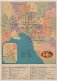
Ephemera - Map - Timetable, Melbourne & Metropolitan Tramways Board (MMTB), "Map and timetable of Melbourne Tram and Bus Services", March 1952
Map provided information about Melbourne's tramway network in 1952. At base of map - timetable of all night trams and bus services. On rear index to routes, 1st and last services, time of Sunday am services, Latrobe St. services and photo of Wattle Park. The conversion of Bourke St to electric trams marked up. Copy 1 - has been marked for hypothetical extensions in blue pencil mainly in the northern and western suburbs. In particular note the Ballarat Road and South Road markings. Copy 2 - has been marked up for newer route numbers, following the opening of the Bourke St services and additional route numbers on the Essendon Depot lines. Demonstrates the provision of information about Melbourne tram services.Fold out map (10 sections - 2 high x 5 wide), coloured of Melbourne's Tram and Bus routes, route numbers, rail lines, municipalities boundaries and location of major places of interest. melbourne, tram and bus services, mmtb, buses, trams, routes, timetables, all night services -
 Melbourne Tram Museum
Administrative record - Tram fare route diagrams or maps, Melbourne & Metropolitan Tramways Board (MMTB), 1930s
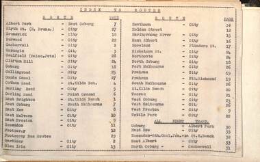
... maps ...The route maps give for each tram, including cable trams, and bus routes, a map of the fare structure, sections, all-night routes, details of transfers and tickets such as combined tickets. Not dated as such but sheet 1 has a note regarding the East Brighton - St Kilda route that it was out of date from 16/10/1938.Yields information about the MMTB fare structure for tram, and bus routes during the 1930s.Album brown card heavy card coves, secured with two interscrews containing a type index, 33 cartridge paper sheets with ink drawings and six loose sheets. Hand drawn in black, red and green ink.mmtb, tramways, fares, maps, routes, buses, cable trams -
Bendigo Historical Society Inc.
Map - SECTIONS ACROSS BENDIGO GOLDFIELD
Map in three sections showing sections across Bendigo Gold Field, showing anticlines, synclines, faults, stratigraphical zones and mines along the reef lines. Key shows rock types Castlemaine, Bendigo B1, B2, B3 and B4, and Lancefieldian. First part of map shows sections A-A, B-B and C-C. Reef lines drawn with mines listed: Fault line shown are the Carshalton, Stafford, New Chum, Virginia and Clarence. A datum line shows 600 ft above sea level. On bottom of plan: ' Prepared in the Geological Survey Office, Bendigo, under the direction of H. Herman, late Director of Geological Survey, from surveys by H.S. Whitelaw, Field Geologist, assisted by E.S. Usher, A.J.J. Moore and R.A. Keble.' Second section of map shows sections D-D, and E-E. Fault lines listed are the Tambour Major fault, Carshalton fault, Stafford fault, Nell Gwynne fault, New Chum fault, Deborah fault. Third section shows sections F-F and G-G. Fault lines listed are the Bird Reef fault, Kangaroo Gully fault, Langdon fault, Carshalton fault, Nell Gwynne fault, Spring Gully fault, Hustlers fault, Gravel Hill fault, Ordes fault, Thanet fault. This map forms part of the Geological Survey of Victoria, Structure of Bendigo Goldfield report, No. 47, 1923. H.Herman, late Director of Geological Survey.Geological Survey of Victoriabendigo, gold mining, reef line maps -
 Melbourne Tram Museum
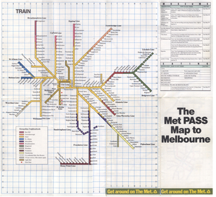
Map, The Met, "The Met PASS Map to Melbourne", c1988/90
... Maps ...Folded Map of Melbourne Rail and Tram lines, titled "The Met PASS Map to Melbourne" Tram Map - probably soon after conversion of the St Kilda and Port Melbourne lines to Light Rail, though these are not shown. Opened November 1987. Rail Map - shows Route 96 north section as Light Rail, co-ordinated bus routes, and the Altona line as going to Werribee. This route was opened in 1985. Date of Map c1988/1990. Has details of Museums, Art Galleries, Shopping, Gardens and Sports Arenas. See also Reg Item 379 for a similar item.trams, tramways, the met, melbourne, maps, tourist tickets -
 Bendigo Historical Society Inc.
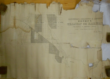
Map - MARKS COLLECTION: TRAMWAY OR RAILWAY MAP SANDHURST
Original map of 'land granted as endowment' for tramway or railway. On top Rh corner of map, in bold print 'Sandhurst, Inglewood & Loddon district Tramway or Railway. Land granted as endowment shaded, scale 60 chains to 1 inch. Lithographed by J & W. Holmes, Lith. Sandhurst'. Signed by Geo Avery Fletcher, Engineer. Map shows Parish of Leichardt, Parish of Yarraberb, Parish of Bridgwater and a section of Marong. On bottom RH corner, is small map of Sandhurst, showing railway reserve. Top LH corner, Inglewood. Map shows route of railway line from Sandhurst to Inglewood.map, marks collection, railway, inglewood -
 Bendigo Historical Society Inc.
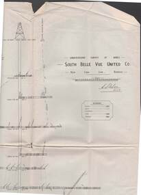
Map - STRUGNELL COLLECTION: UNDERGROUND SURVEY OF MINES, BENDIGO, 29-3-01
Map, Underground Survey of Mines, Bendigo, South Belle Vue United Co.,New Chum Line.Transverse Section. Signed H.S.Whitelaw29.3.01 Drawing appears to show samples of connecting horizontal shafts with their respective mineral contentsH.S.Whitelawmap, bendigo, south belle vue united co.. -
 Whitehorse Historical Society Inc.
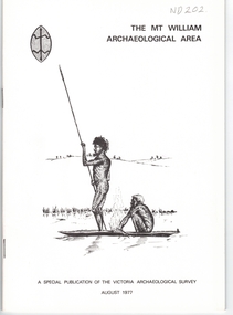
Document, Mt William Archaelogical Area, 1/08/1977 12:00:00 AM
Booklet issued by the Victorian Archaelogical Survey describing an abouiginal axe quarry at Mt William near Lancefield. The history of the site is described as is the archaelogical evidence.Booklet issued by the Victorian Archaelogical Survey describing an abouiginal axe quarry at Mt William near Lancefield. The history of the site is described as is the archaelogical evidence. A section describes the importance of axes in aboriginal culture. Map, illustrations.Booklet issued by the Victorian Archaelogical Survey describing an abouiginal axe quarry at Mt William near Lancefield. The history of the site is described as is the archaelogical evidence. aborigines, stone axes, mount william -
 Melbourne Tram Museum
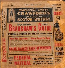
Book - Bradshaws Guide - November 1941, Stillwell & Stephens Pty Ltd
Provides detailed information on Victorian railways country timetables, suburban trains, lists of post offices, Victorian and Commonwealth Government officials and elected representatives, and tramways - all night services, first and last cars, including Sandringham and St Kilda services. Provides a detailed guide to services in Victoria, including public transport.Book - 194 pages, 9 sections stapled paper titled "Bradshaws Guide - November 1941" Priced 8d, No. 1029. Has a fold out map of the VR Country and suburban lines. Includes many advertisements.victoria, tramways, melbourne, timetables, railways, guides, bradshaws guide, advertisements -
 Stawell Historical Society Inc
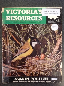
Book, Natural Resources Conservation, Victoria's Resources - Vol 3 No 4, 1962
Departments, Regions, Municipalities and Organisations which are members of the Conservation League. These books were provided free of charge to residents.Paper cover: 3/4 Green strip with white & black print. Black section containing map of Victoria below a colour picture of a nesting mother bird with chicks below black strip with white printVictori's Resources Vol 3. No. 4. December 1961 February 1962. Published Quarterly Price 1'6 Golden Whistler Beautiful Insectivorous bird widespread thoughout Australiatourism -
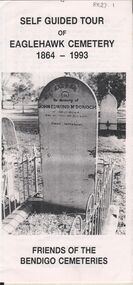 Bendigo Historical Society Inc.
Document - BENDIGO CEMETERIES COLLECTION: SELF GUIDED TOUR EAGLEHAWK CEMETERY DOCUMENT
BHS CollectionWhite trifold document. Self guided tour of Eaglehawk Cemetery 1864 - 1993 Friends of the Bendigo Cemeteries. Document details significant graves in the old monumental section 1864 - Map of graves and 35 graves described.Annette O'Donohue, Bev Hanson.bendigo, cemetery, eaglehawk cemetery -
 Kew Historical Society Inc
Map, MMBW, MMBW Plan No.39 Kew & Heidelberg, 1900-1910
The Melbourne and Metropolitan Board of Works (MMBW) was established by an act of the Victorian Parliament in 1890 to prepare for and to implement a sewerage and water reticulation system across what was then inner Melbourne, its surrounding and middle distance suburbs, including Kew. The MMBW was disbanded in 1991.The map collection of the Kew Historical Society has at its core the historic maps assembled and originally stored in the City Engineer's Department of the City of Kew. These include maps in a number of scales. The vast majority of maps were produced by the MMBW in the first two decades of the twentieth century, and are solid working maps, backed by linen for durability. These maps are historically significant to Kew, the City of Boroondara and to the history of the development of state utilities in Victoria. A number of the Kew maps have additional details added by former municipal officers, including the levels reached by various floods. As these were working documents, information was added to them long after the period of their initial production and distribution.Early map of part of the Borough of Kew, created in the first decade of the twentieth century, at a scale 160 ft to 1 inch. The map covers what was then the north western section of Kew, bordered on its north by Wills Street and the Kew Lunatic Asylum, in the west by the River Yarra [and the later added Yarra Boulevard] , by Princess Street in the East and Holroyd Street in the south. The map shows the extent of urban development by that time, prominent institutions and the outlines of built structures in the municipality. Contour lines were added in ink to the map at a later stage.MELBOURNE AND METROPOLITAN BOARD OF WORKS / PLAN NO. 39 / KEW & HEIDELBERGmelbourne & metropolitan board of works, mmbw maps, mmbw plans, borough of kew, cartography -
 Melbourne Tram Museum
Map, Ministry of Transport, "Melbourne Public Transport Map", c1977
Fold out map (27 sections 9 across x 3 deep), coloured of Melbourne's Tram and Bus routes, route numbers, rail lines, detailed for the central part of Melbourne and insert section for Frankston. On rear description of routes, private bus routes and map of Melbourne metro lines. Has contact details for bookings and lost property etc. Priced 20c Dated 1977, says No. 6 on bottom of rear cover. Note shows route 59 being cut back to the highway.trams, tramways, melbourne, map, tram & bus services, railways, mmtb, minister for transport -
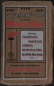 Melbourne Tram Museum
Map, Sands McDougall, Map of Melbourne and Suburbs showing Tramways, Railways, Streets, postal districts, Quarter-Mile Radii etc", c1919
... maps ...Shows railways, cable and electric tram lines c1919. One of a number of maps produced by Sands McDougall of Collins St. Includes the MTOCo zoo horse tram lines, the PMTT, HTT and MBCTT lines, but not the FNPTT or the FTT lines. See items 2885 and 6573 for other editions. Yields information about Melbourne c1919 and its public transport lines. Produced by Sands and McDougall Pty Ltd of Collins St Melbourne. folded sheet of paper 6 sections wide x 6 sections or folds deep contained within a brown paper cover titled "Map of Melbourne and Suburbs showing Tramways, Railways, Streets, postal districts, Quarter-Mile Radii etc", showing both cable and electric tramways. maps, melbourne, cable trams, tramways, railways, horse trams, nmetl, vr trams, sands mcdougall, mbctt, pmtt, htt, zoo horse tramway -
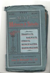 Melbourne Tram Museum
Map, Sands McDougall, Map of Melbourne and Suburbs showing Tramways, Railways, Streets, postal districts, Quarter-Mile Radii etc", c1922
... maps ...Shows railways, cable and electric tram lines c1922. One of a number of maps produced by Sands McDougall of Collins St. Includes the Zoo horse tram lines. See acquisition and Research note by Duncan McAuslan. See items 2885, 6573, amd 6917 for other editions. On inside cover has current postal rates (including a war surcharge) and places worth visiting and on the rear cover, is an advertisement for Imperial ink.Yields information about Melbourne c1922 and its public transport lines. Produced by Sands and McDougall Pty Ltd of Collins St Melbourne. Folded sheet of paper 6 sections wide x 6 sections or folds deep contained within a green paper cover titled "Map of Melbourne and Suburbs showing Tramways, Railways, Streets, postal districts, Quarter-Mile Radii etc", showing both cable and electric tramways. maps, melbourne, cable trams, tramways, railways, horse trams, vr trams, sands mcdougall, zoo horse tramway, mmtb