Showing 250 items
matching residence sites
-
 Bendigo Historical Society Inc.
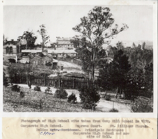
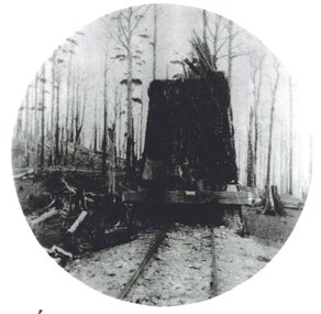
Photograph - HIGH SCHOOL SITE, TAKEN FROM CAMP HILL SCHOOL, 1870
Black and white photograph of high school site taken from Camp Hill School in 1870, looking North East. Inscriptions: Identification of buildings typed on attached paper. Far left is the Corporate High School, the Police Office is the long building, the Supreme Court building at read and the Principal's residence towards the foreground. The vegetation and path in the front is now part of the Camp Hill Primary School.place, landscape view -
 Bendigo Historical Society Inc.
Photograph - BENDIGO HISTORICAL SOCIETY COLLECTION: MATHIESON'S HOTEL, KNOWSLEY
Colour photograph of Mathieson's Hotel, Knowsley. Weatherboard building with iron roof, verandah at front. Hotel is also known locally as Cosmos and has been used as a residence for many years. Currently owned by Don and Carol White, Knowsley. Photo taken on BHS tour. Burke and Wills Expedition camped near this site in 1860, allegedly opposite the Mathieson's Hotel.buildings, commercial, mathieson's hotel, knowsley -
 Bendigo Historical Society Inc.
Document - ALBERT RICHARDSON COLLECTION: VICTORIA HILL IRONBARK
Three page handwritten document outlining the history of the Victoria Hill area. The open cuts on Victoria Hill; Lansell's Big 180 Mine, Victoria Quartz Mine; Wittscheibe's 'Jewellers Shop', Luffman and Sterry, Central Nell Gwynne and New Chum Hill are mentioned in the article. A description of the suitability of the Victoria Hill site as a potential mining museum is discussed as 'it is centrla to both the northern and southern ends of the main portion of the Bendigo and Eaglehawk mines'. William Rae built two fine residences on Happy Valley Road, and also set up a 30 head battery out of his gains from Victoria Hill.bendigo, mining, victoria hill -
 Bendigo Historical Society Inc.
Photograph - RALPH BIRRELL COLLECTION: TREE AT FORMER GUNPOWDER MAGAZINE, WHITE HILLS
Colour photograph of tree 'planted around the gunpowder magazine site in the 1880's, most of which still remain' at White Hills, Bendig ( at the end of Riley Street) The magazine keeper's residence is nearby and is in use as private residence. A magazine for gelignite was built nearby on the site of the Bendigo East School in 1883 and was pulled down in 1915. (see Mosaic 4400.220 for detailed information regarding the White Hills, written by Dr. Ralph Birrell)bendigo, mining, white hills -
 Bendigo Historical Society Inc.
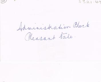
Negative - LA TROBE UNIVERSITY BENDIGO COLLECTION: BENDIGO TEACHERS' COLLEGE ADMINISTRATION BLOCK
A white envelope with the words ' Administration Block Pleasant Vale' written on the front. The number 14 is at the top on the left hand side. Inside is a negative only of the administration block at Bendigo Teachers' College. In the background is the Principal's Residence ' Pleasant Vale'.bendigo, education, bendigo teachers' college, la trobe university bendigo collection, collection, bendigo teachers' college, administration, buildings, site, place, ' pleasant vale, ' education, tertiary education, residence, teacher trainiing, negative -
 Tatura Irrigation & Wartime Camps Museum
Photograph - copy, D. Clark, Brown's Bakery and residence, 1989 copy
Photograph showing residence of Browns Bakery and part of shop and old palm tree on left. Also part of Collivers shop on right. Zappias Pharmacy now on bakery site.Black and white copy photograph of residence and part of Brown's bakery, Hogan Street, Tatura. Late 1940's.on back: Browns Bakery and residencebrowns bakery -
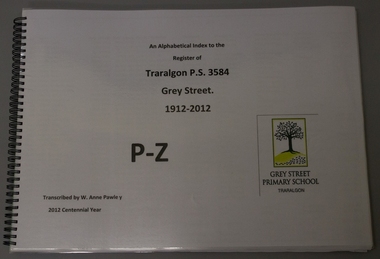 Grey Street Primary School, Traralgon
Book, spiral bound, An alphabetical index to the / Register of / Traralgon P.S. 3584 / Grey Street / 1912- 2012 / P - Z, 2012
This transcription is organised alphabetically making it very ease when searching for family names and information. The columns include Register number, Name, DOB, Date of Admission, Name of Parent/Guardian, Residence of Parent/Guardian, Occupation of Parent/Guardian, School last attended and date, Last attendance and Destination. There are 13420 pupils recorded in this transcription which covers 100 years of Education on the Grey Street site. This transcription set has been divided into 4 volumes for ease of handling.The database in alphabetical order was printed onto A3 pages for ease of reading and has laminated front and back covers.grey street., traralgon, pupil, register, transcription -
 Ruyton Girls' School
Photograph - Studio Portrait, [Henry Henty], c.1890
Henry Henty (b.1833-d.1912) was a successful businessman, and briefly a MLA for the seat of Grenville, Victoria in 1866. He was one of three sons of James Henty, and nephew of Edward Henty who is considered to be the first permanent European colonist to take up residence in Victoria. Henry Henty and his wife Marion Ann Henty (nee McKellar) had ‘Tarring’, Kew built for their family in 1872. The Henty family resided at ‘Tarring’ until the death of Marion Henty in 1919. ‘Tarring’ was then sold to Ruyton Girls’ School, and the School moved to the site, (now 12 Selbourne Rd, Kew) in 1920. ‘Tarring’ was renamed ‘Henty House’ in honour of its original owners. Half-length, sepia-toned studio portrait of Mr Henry Henty (b.1833-d.1912). Mr Henty wears a dark suit and tie. His body is one quarter turned to his left, while he looks straight towards the camera. The background behind him is plain and dark. Photograph is mounted on cream card.henry henty, tarring, marion henty, selbourne road, kew (vic), ruyton girls' school, businessman, politician, 1890s -
 Stawell Historical Society Inc
Photograph, Black Range Quarry Site
Black Range Quarry SiteOn Reverse Bullocky Mary's House (Mary Honan) On Bullocky Mary Road. Remains of Residence are nearly to Mr Snooks Fence.stawell -
Nillumbik Shire Council
Mixed Media (installation): John R. NEESON (b.1956 AUS), John R Neeson, Riverbend Project, 2015
John R Neeson was a Laughing Waters Artist in Residence in 2015. During his residency Neeson made site specific trompe-l’oeil paintings and time based videos that referenced the changes of light upon the Knox architecture and the environment of Laughing Waters.Wooden easel holding an oil on board painting of the Yarra River and surrounding landscape at Laughing Waters (detailed view). Behind the painting and easel is a digital photograph of the painting and easel in situ in the landscape. The photograph is printed on aluminium. No inscriptions and markingsekphrasis 2016, neeson, easel, oil painting, yarra river, digital photograph, landscape, in situ, site specific, riverbend -
 Whitehorse Historical Society Inc.
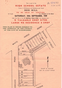
Document, High School Estate, 1949
Advertisement for High School Estate,Advertisement for High School Estate, Box Hill auction on 24/9/1949 of residence and shop and 15 shop sites including plan of development.Advertisement for High School Estate, auctions, high school estate box hill, middleborough road, box hill, flora avenue, whitehorse road -
Whitehorse Historical Society Inc.
Document, The Walker Estate Mitcham, 8/10/1938 12:00:00 AM
Executor's Realisation Auction of the Walker Estate.Executor's Realisation Auction of the Walker Estate of 12 building sites at 1 pm and the residence of E.E Walker at 3 pm, 8 Oct 1938Auctioneers: Edward Haughton Pty Ltd Drake & Co Solicitors: Gillott, Moir & AhernExecutor's Realisation Auction of the Walker Estate.walker estate, mitcham, walker, edgar edwardes -
Whitehorse Historical Society Inc.
Document, Walker Estate Mitcham, 8/10/1938 12:00:00 AM
... Auction brochure for 'Beautiful brick residence' of 9 rooms... sites for brick residences, Saturday 8th October 1938. Auction ...Auction brochure for 'Beautiful brick residence' of 9 rooms, with 1 1/2 acres of grounds, subdivided into 12 sites for brick residences, Saturday 8th October 1938.Auction brochure for 'Beautiful brick residence' of 9 rooms, with 1 1/2 acres of grounds, subdivided into 12 sites for brick residences, Saturday 8th October 1938, by order of the Executors of the late E. E. Walker. Frontages to Mitcham Road, Agra Street, Simla Street and Meerut Street. Auctioneers: Edward Haughton Pty Ltd and Drake & Co. Original copy framed, located in Map Drawer.Auction brochure for 'Beautiful brick residence' of 9 rooms, with 1 1/2 acres of grounds, subdivided into 12 sites for brick residences, Saturday 8th October 1938.walker, edgar edwardes, walker estate, mitcham road, mitcham, agra street mitcham, simla street mitcham, meerut street mitcham, drake & co., edward haughton pty ltd -
Whitehorse Historical Society Inc.
Document, Splendid home sites, 1938?
Sale brochure for 23 home sites and 'Gentleman's delightful country residence',.Sale brochure for 23 home sites and 'Gentleman's delightful country residence', frontages to Mitcham Road, Calcutta Street, Simla Street, Benares Street and Delhi Street. Agents: Baillieu Allard Pty Ltd and Drake & Co.Sale brochure for 23 home sites and 'Gentleman's delightful country residence',.walker estate, mitcham road mitcham, simla street mitcham, benares street mitcham, calcutta street mitcham, delhi street mitcham, drake & co., baillieu allard pty ltd -
 Whitehorse Historical Society Inc.
Document - Report, The Pound House, 1998
Report on The Pound House, 988 Canterbury Road, Box Hill South, by Andrew Ward, architectural historian.Report on The Pound House, 988 Canterbury Road, Box Hill South, by Andrew Ward, architectural historian. The report details the history of the site which was the first Shire Hall of the Shire of Nunawading and then the residence of the pound keeper. The building is described. Photographs. 7 pages.Report on The Pound House, 988 Canterbury Road, Box Hill South, by Andrew Ward, architectural historian. bills, annis, george, fairbanks, g, j, bennett, s, bishop, edward, bayley, leonard sherwin, blood, robert, norman & hayes, kennedy, bob, city of box hill, shire of nunawading -
 Whitehorse Historical Society Inc.
Photograph, View from Mitcham Pedestrian Bridge, 1/07/2000 12:00:00 AM
Coloured photo from the pedestrian overpass on Whitehorse Road, Mitcham, looking north-east towards the Mitcham Shopping Centre.- North - side. House with Spanish taste belonged to Mr. Peake of Peake and Cox, the timber yard directly across Whitehorse Road from this house which became the new site of St.John's Roman Catholic Primary School. This house was on the corner of Whitehorse Road and Albert Street. Upon the sale of the timber yard and mill the catholic church the house was also sold to the church and was occupied as a residence for the school's teaching Sister's. (House since demolished)whitehorse road, mitcham, pedestrian overpass -
 Whitehorse Historical Society Inc.
Photograph, Warrender Hospital
Four copies of Warrender Hospital and Surgery run by Dr. Stanley Cochrane, Harrison Street- McDowall corner, Mitcham - site now occupied by R.S.L. Originally Dr. Cochrane's extremely large home the hospital became two private family dwellings when its activities as hospital ceased . Dr. Cochrane had consequently built a private residence/surgery on the corner of Mitcham Road and Harrison Street.warrender hospital, cochrane, stanley, dr., mitcham private hospital -
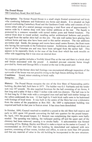
 Ballarat Heritage Services
Photograph, Fernleigh Flats, Ballarat, 12/02/2022
Residents of the Fernleigh Flats Retirement village are understood to be well and strong enough to care for themselves and need to be over the age of 55 years. Fernleigh Flats is owned and operated by the Seventh Day Adventist Church. "TO LET, a Brick House, corner of Urquhart and Ripon Streets. Apply Owen Cazaly, Mining Exchange."(Ballarat Star, 16 Aug 1867) "SALE BY AUCTION, Corner of Urquhart and Ripon streets, 07 COMFORTABLE COTTAGE PROPERTY. M'GREGOR BROTHERS, instructed by the owner, Mr Bradbury, who has bought another property, will sell by public auction, on Monday, 16th May, at half-past 12, His six-roomed substantially-built RESIDENCE. The owner has, under his own supervision, spared no expense in making this a most comfortable and convenient dwelling, situated on a quarter of an acre allotment, at the corner of Urqhuart and Ripon streets, high and dry. Garden laid out with choice young fruit trees; ground capable of growing anything. Fowl yard fenced off. making It a most desirable residence. For a family residence or as An investment this is a good opportunity. Inspection invited. Auctioneer, R. M'GREGOR. (Ballarat Star, 12 May 1893.)A retirement village on the corner of Urquhart Street and Ripon Street, Ballarat. The street trees surrounding this property include a number of trees (blue cedar?) and suggest the demolition of an older stately home on this site. fernleigh flats, residences, architecture -
 Whitehorse Historical Society Inc.
Photograph, 459 Whitehorse Rd. Mitcham
The house used to be the residence of Mr. Arthur Peake, owner of Peake and Cox, timber merchants, Mitcham. The house was on one side of Whitehorse Road and the mill was directly opposite. The Catholic Church built a primary school on the timber mill site and the teaching sisters lived in the house, which has now been demolished to make way for flatsColoured photograph of a house at 459 Whitehorse Rd. Mitcham, that had been built for Mr. Arthur Peake, timber merchant of Mitcham. House has 2 adobe-style archeswhitehorse road mitcham, no. 459 peake, arthur.timber merchants -
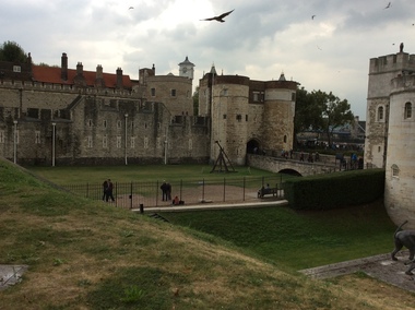 Ballarat Heritage Services
Digital photograph, Dorothy Wickham, Tower of London, 2016
The Tower of London, officially Her Majesty's Royal Palace and Fortress of the Tower of London, is a historic castle located on the north bank of the River Thames in central London. It lies within the London Borough of Tower Hamlets, separated from the eastern edge of the square mile of the City of London by the open space known as Tower Hill. It was founded towards the end of 1066 as part of the Norman Conquest of England. The White Tower, which gives the entire castle its name, was built by William the Conqueror in 1078, and was a resented symbol of oppression, inflicted upon London by the new ruling elite. The castle was used as a prison from 1100 (Ranulf Flambard) until 1952 (Kray twins),[3] although that was not its primary purpose. A grand palace early in its history, it served as a royal residence. As a whole, the Tower is a complex of several buildings set within two concentric rings of defensive walls and a moat. There were several phases of expansion, mainly under Kings Richard the Lionheart, Henry III, and Edward I in the 12th and 13th centuries. The general layout established by the late 13th century remains despite later activity on the site. The Tower of London has played a prominent role in English history. It was besieged several times, and controlling it has been important to controlling the country. The Tower has served variously as an armoury, a treasury, a menagerie, the home of the Royal Mint, a public record office, and the home of the Crown Jewels of England. From the early 14th century until the reign of Charles II, a procession would be led from the Tower to Westminster Abbey on the coronation of a monarch. In the absence of the monarch, the Constable of the Tower is in charge of the castle. This was a powerful and trusted position in the medieval period. In the late 15th century the castle was the prison of the Princes in the Tower. Under the Tudors, the Tower became used less as a royal residence, and despite attempts to refortify and repair the castle its defences lagged behind developments to deal with artillery. The peak period of the castle's use as a prison was the 16th and 17th centuries, when many figures who had fallen into disgrace, such as Elizabeth I before she became queen, Sir Walter Raleigh, and Elizabeth Throckmorton were held within its walls. This use has led to the phrase "sent to the Tower". Despite its enduring reputation as a place of torture and death, popularised by 16th-century religious propagandists and 19th-century writers, only seven people were executed within the Tower before the World Wars of the 20th century. Executions were more commonly held on the notorious Tower Hill to the north of the castle, with 112 occurring there over a 400-year period. In the latter half of the 19th century, institutions such as the Royal Mint moved out of the castle to other locations, leaving many buildings empty. Anthony Salvin and John Taylor took the opportunity to restore the Tower to what was felt to be its medieval appearance, clearing out many of the vacant post-medieval structures. In the First and Second World Wars, the Tower was again used as a prison, and witnessed the executions of 12 men for espionage. After the Second World War, damage caused during the Blitz was repaired, and the castle reopened to the public. Today the Tower of London is one of the country's most popular tourist attractions. Under the ceremonial charge of the Constable of the Tower, it is cared for by the charity Historic Royal Palaces and is protected as a World Heritage Site.(Wikipedia) A World Heritage Site is a landmark which has been officially recognized by the United Nations, specifically by UNESCO. Sites are selected on the basis of having cultural, historical, scientific or some other form of significance, and they are legally protected by international treaties. UNESCO regards these sites as being important to the collective interests of humanity. More specifically, a World Heritage Site is an already classified landmark on the earth, which by way of being unique in some respect as a geographically and historically identifiable piece is of special cultural or physical significance (such as either due to hosting an ancient ruins or some historical structure, building, city, complex, desert, forest, island, lake, monument, or mountain) and symbolizes a remarkable footprint of extreme human endeavour often coupled with some act of indisputable accomplishment of humanity which then serves as a surviving evidence of its intellectual existence on the planet. And with an ignoble intent of its practical conservation for posterity, but which otherwise could be subject to inherent risk of endangerment from human or animal trespassing, owing to unmonitored/uncontrolled/unrestricted nature of access or threat by natural or accelerated extinction owing to local administrative negligence, hence it would have been listed and demarcated by the United Nations Educational, Scientific and Cultural Organization (UNESCO) to have been identified or recognised and officially christened and internationally elevated through multilateral declaration by UNESCO as a universally protected zone. [1] The list is maintained by the international World Heritage Programme administered by the UNESCO World Heritage Committee, composed of 21 UNESCO member states which are elected by the General Assembly. (Wikipedia)The Tower of London is a UNESCO world heritage site.tower of london -
 Ballarat Heritage Services
Photograph - Photograph - Colour, Dorothy Wickham, Ballarat Female Refuge, 2000
Ballarat Female Refuge was established in 1867 by a group of 26 Ballarat ladies. It was moved to the present site in Scott's Parade in 1884. It is now a private residence.Postcard size colour photgraphs showing the interior and exterior of the Ballarat Female Refuge. ballarat femail refuge, welfare, town and city mission, alexandra babies home, baby, orphanage, sarah ellis -
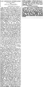 Old Colonists' Association of Ballarat Inc.
Photograph - Newsclipping, The Old Colonists' Association of Ballarat, 1888, 1888
The Old Colonists' Association Ballarat Inc. is a not for profit charitable organisation providing accommodation for elderly people. It manages a 27 Home retirement village at Charles Anderson Grove Ballarat. Accommodation is offered at significantly below market rates. It has been providing low cost accommodation to the elderly since the 1920s. The Association Council overseas the running of this facility on a voluntary basis. OLD COLONISTS' ASSOCIATION OF BALLARAT. (FROM OUR CORRESPONDENT.) BALLARAT, WEDNESDAY. This association, which was founded in August, 1883, and at first known as the Old Identities' Association, now has a roll of 450 members. The objects of the association are "to aid and assist indigent or suffering old colonists ; to raise a fund, by the voluntary subscriptions of the members and the aid of outside donations, for the purpose of relieving members in sickness and old age; for assisting those in extreme distress, to provide the shelter of a home for old and indigent pioneers of the gold fields, their widows, or anyone connected with the association, and in the event of the death of any member to have his remains decently buried, the association defraying the expenses of the funeral (providing that no funds or property are left by the deceased), and to attend the funeral if so desired by the relatives." The qualifications for member ship are good character and repute, and residence in the colonies for a quarter of a century. For some time the association had no property except the regular subscriptions, but about a year ago they obtained from the Minister of Lands the grant of a very valuable block of land in Lydiard-street, the Crown grant of which they received last week. This block has a frontage of 66ft to Lydiard street, worth at least £100 a foot. The ground was given to the association as a site for them to build a hall upon, and with so valuable an asset they had no difficulty in borrowing at 7 per cent, enough money to construct a hall. For revenue purposes the ground floor of the building has been made into four shops, and the rental from these, judging from the rentals of shops in the vicinity, will not only pay all the interest on the borrowed money, but over £200 a year towards clearing off the principal. The officers of the association are Messrs J. P. Murray, President; J. W. Graham and T. Stoddart, vice presidents; D. Fern, treasurer; and J. Fraser, secretary. The Old Colonists' Hall is an elegant looking building in Lydiard-street, lying between the newly-opened mining exchange and the Commercial Club house, and a few doors north of the Post Office. The style of the facade is classic. The lower portion of the front is constructed of Waurn Ponds stone, forming piers, and the upper portion of brick and cement, the background being tuckpointed. The centre bay is carried by two three quarter columns with Ionic cups, which support a pediment on which is set a cast of the Ballarat coat of arms. The four other bays are supported by pilasters with Corinthian caps mid partly fluted. The entrance is through a spacious circular headed doorway, the keystone of the arch of which bears a sculptured head, in marble, representing that of the president of the Old Colonists' Association here, Mr. John P. Murray. An ample vestibule leads to a wide stone staircase which ends at a spacious landing. The landing has a dome over the centre, with cornice and enrichments, and is lighted from above. The walls round the landing are panelled with marble slabs, which are to be appropriately inscribed in the future. On the first door are the rooms appropriated to the association. The principal of these is a hall 44ft x 33ft and 17ft high. This room is well ventilated and lighted from the back of the building with large windows, and the walls are finished with Keene's cement. The other rooms are committee room, 14ft x 16ft; secretary's, 14ft x 17ft, 6in; kitchen, bedrooms, bathroom, &c. The front portion of the first floor is arranged so that it may be let for offices, or utilised for club purposes. Suitable provision has been made throughout for lighting, ventilation, and means of egress. The architect for the edifice is Mr A. G. Legge, of this city, and the contractors are Messrs. Whitelaw and Atkinson, Irving and Glover, Reynolds, and J. Donaldson. The total cost of the building when completed, which will be in a few weeks, will be about £4,000. (The Argus, 10 May 1888)ballarat old colonists' club, charles anderson grove, old colonists' association -
 Otway Districts Historical Society
Photograph, Crowes: Terminus of the railway line, 1911
The terminus of the railway, and the southern-most station on the Australian mainland, was Crowes, approximately 2 kilometres from Lavers Hill. The line ended at "The Black Stump". Crowes was designed as a fully functioning terminus and received a complete instalment of facilities. The site was laid out with three roads plus a dead end siding for a locomotive shed and ash pit. Goods sheds, a platform and livestock ramps catered for freight loadings, while on the north side was a station office, waiting room, parcels shed and passenger shelter. Three departmental residences were also provided. The resident Station Master was withdrawn in November 1916 and the station closed with the line on 10 December 1954.Photograph. Terminus of the Colac-Crowes at Crowes.crowes; terminus; "the black stump"; -
 Bendigo Historical Society Inc.
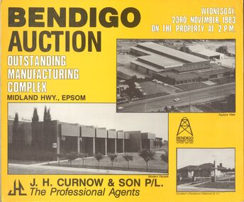
Document - IAN DYETT COLLECTION: AUCTION NOTICE
Three yellow, black and white placards advertising the auction of a manufacturing complex on the Midland Hwy., Epsom, held on 23rd November, 1983. On the front are two photos of the complex and a photo of the Caretaker's Residence. J. H. Curnow & Son P/L were the auctioneers. On the back are photos of Factory 1 (with crane), General Office, Amenities Courtyard, Factory 2, Mezzanine Office and the Modern Boardroom. There is Plan of site, Site relation to city and Situation in State. A list of area, frontage, benefits, terms and vendor's solicitors - Hyett, Ellinhaus John & Morrison. Instructed by McNiece Bros. Pty Ltd.business, auctioneers, j h curnow & son pty ltd, ian dyett collection - auction notice, j h curnow & son p/l, huntly shire, hyett ellinhaus john & morrison, mcniece bros pty ltd, resi auctioneers -
 Kew Historical Society Inc
Plan, Melbourne & Metropolitan Board of Works : Borough of Kew : Detail Plan No.1585, 1904
The Melbourne and Metropolitan Board of Works (MMBW) plans were produced from the 1890s to the 1950s. They were crucial to the design and development of Melbourne's sewerage and drainage system. The plans, at a scale of 40 feet to 1 inch (1:480), provide a detailed historical record of Melbourne streetscapes and environmental features. Each plan covers one or two street blocks (roughly six streets), showing details of buildings, including garden layouts and ownership boundaries, and features such as laneways, drains, bridges, parks, municipal boundaries and other prominent landmarks as they existed at the time each plan was produced. (Source: State Library of Victoria)This plan forms part of a large group of MMBW plans and maps that was donated to the Society by the Mr Poulter, City Engineer of the City of Kew in 1989. Within this collection, thirty-five hand-coloured plans, backed with linen, are of statewide significance as they include annotations that provide details of construction materials used in buildings in the first decade of the 20th century as well as additional information about land ownership and usage. The copies in the Public Record Office Victoria and the State Library of Victoria are monochrome versions which do not denote building materials so that the maps in this collection are invaluable and unique tools for researchers and heritage consultants. A number of the plans are not held in the collection of the State Library of Victoria so they have the additional attribute of rarity.Original survey plan, issued by the MMBW to a contractor with responsibility for constructing sewers in the area identified on the plan within the Borough of Kew. The plan was at some stage hand-coloured, possibly by the contractor, but more likely by officers working in the Engineering Department of the Borough and later Town, then City of Kew. The hand-coloured sections of buildings on the plan were used to denote masonry or brick constructions (pink), weatherboard constructions (yellow), and public buildings (grey). This plan, which covers parts of High Street, Pakington Street and Derby Street is dominated by two historic Kew mansions: ‘Konetta’ and ‘Ramornie’. Ramornie was constructed in 1890 for James Maitland Campbell, three times Mayor of Kew. Sold in 1940, it became a boarding house known as ‘The Towers’. Now a private residence again, it has only one of its three balconies remaining. The location of the missing two balconies can be seen on the plan. In 1903, the grounds of Ramornie included a large tennis court fronting Pakington Street. The rear of the property is shown as extending to Cobden Street. One of Kew’s oldest hotels, the Prospect Hill Hotel on the corner of High and Cobden Street was established in 1858. The outline of the hotel shown on the plan represents the second building on the site. During the 19th century it was often used for electoral meetings. The Prospect Hill Hotel was to be redeveloped again in 1928, by the local architect Robert McIntyre. Since the 1980s, the hotel has been a live music venue, the home of the Melbourne Jazz Club, a restaurant and a liquor outlet.melbourne and metropolitan board of works, detail plans, maps - borough of kew, mmbw 1585, cartography -
 Kew Historical Society Inc
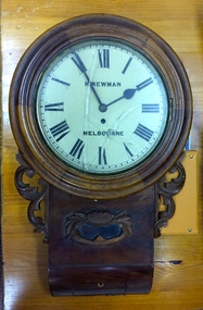
Functional object, H Newman, Boxed Wall Clock, 19th Century
DEATH OF MR. H. NEWMAN. Widespread regret will be felt at the announcement of the death of Mr Henry Newman, an old colonist and a member of firm of Newman and Sons Proprietary Limited, jewellers, which occurred at his residence, "Sadova," William street, on Saturday, at the age of 89 years. Mr Newman who was born at Riga, in Russia, went to England when a lad, became naturalised, and emigrated to Victoria 61 years ago. He tried his fortune at Ballarat but soon afterwards returned to Melbourne, and began business as a jeweller, on a site in Collins street that is now occupied by Scott's Hotel. A few years later Mr Newman went back to England, where he was married. On his return to Victoria again he resumed his jewellery business in Elizabeth street opposite the General Post-office. An interesting fact in connection with his business is that his first journeyman watchmaker was Mr. Thomas Gaunt, the founder of the firm of Messrs. T. Gaunt & Co. Five years ago Mr. Newman retired from the business, which has since been carried on by his two elder sons. Although he took no active part in public affairs, Mr Newman was held in high regard on account of his business integrity, sterling personal worth. and the unostentatious way in which he did good. His vitality, even in his later years, was wonderful. On four occasions he met with accidents, having been twice knocked down by motorcars and twice by trams, without having sustained injury. A widow and grown up family of four sons and four daughters survive him. The Age Monday 27 October 1913, page 9. Roy Cronin 156 High Street Kew Jeweller and watchmaker. East side between Denmark Street and Cotham Road. Wood, enamel, brass and glass wall clock, the movement made by H Newman of Collins Street, Melbourne. A small label on the interior records the name R. Cronin, 156 High St, Kew, 1/7/20. It is unclear whether Cronin, a watchmaker and jeweller may have repaired or sold the clock. The clock (broken) is housed in a steel box.roy cronin - watchmaker - jeweller - kew (vic), h newman - melbourne (vic) - collins street - jeweller - clockmaker -
 Kew Historical Society Inc
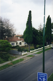
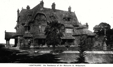
Photograph, 'Goathland', The Residence of Sir Malcolm D McEacharn, 1901-1911
The architect, Edward Kilburn designed Byram in the Arts & Crafts style for the industrialist George Ramsden. Construction began in 1888 and was reputed to have lasted three years. The mansion had frontages to Studley Park Road and Stevenson Street, including gardens laid out with great taste, including pleasure grounds, tennis lawn, fruit and flower garden, and paddock.The size of many of the trees in the garden indicate that many survived from the garden of Clifton Villa, the previous single-storeyed house built on the site by the Stevenson brothers. Byram had views to Melbourne and Port Phillip Bay. The house was demolished in 1960, despite opposition from the National Trust (Victoria), and its gardens subdivided into residential allotments.An early photograph of Goathland (also known as Byram, Lowan and Tara Hall). The photo shows the front of the building during the period of Sir Malcolm McEacharn’s occupation of the house (1901-11). Edward George Kilburn, of Ellerker & Kilburn, had originally designed the house for the industrialist George Ramsden in 1888. When Sir Malcolm McEacharn purchased Byram, he was to rename it as Goathland. This has led to some confusion, as Goathland was also the name used for McEacharn’s other home in St. Kilda. The period of McEacharn’s ownership represented the high point of the mansion’s history. 'Lost Glories: a memorial to forgotten Australian buildings' was published by David Latta in 1986. It tells the story of a number of significant Australian buildings that had previously been demolished. A chapter in the book was devoted to Goathland, later known as Tara Hall. To supplement the text, he sourced photographs from a range of suppliers, chiefly the Royal Women's Hospital which had once owned Tara Hall, but had sold it in 1960. This is one of the photographs donated to KHS by the author."'Goathland', The Residence of Sir Malcolm D McEacharn"byram, goathland, tara hall, lowan, studley park road -- kew (vic.), melbourne mansions, e g kilburn - architect -
 Kew Historical Society Inc
Photograph - 'Carronbank', Marshall Avenue, 1980s
Carronbank (demolished) in Marshall Avenue, Kew was once the home of the Rev Graham Henty Balfour. It had extensive grounds, including a tennis court at the rear of the property. It remained a private residence until c.1960. The Department of Education purchased Carronbank as a school for partially sighted children, opening in February 1961 as State School No 4483. During the period 1961 to c.1980, the building housed a number of services. From 1969 to 1974, it was the site of Carronbank State School, later renamed Carronbank School for Deaf-Blind Children. In 1973, the Department established the Visiting Teacher Service for the Visually Impaired at the site. Its aim was to support teachers working in Victorian Government, Catholic and Independent Schools. From 1983 the school operated as Statewide Resource Centre for Visiting Teachers of the Vision Impaired. In 1988, the amalgamation of Princess Elizabeth Junior School for Deaf Children, the Monnington Centre and Carronbank School for Deaf Blind Students allowed the Victorian Government to sell each of the sites. Monnington [Adeney Avenue, Kew] reverted to private ownership, while Glendonald and Carronbank in Marshall Avenue were demolished and subdivided.The donor, Mr Murray Osler, was Principal of the Monnington Special Education Centre in Adeney Avenue (Kew) from 1976. This photo, and an accompanying drawing of 'Monnington' are important primary resources for the delivery of education to and for deaf-blind children in Victoria.The photograph, framed under perspex, shows the tennis court of Carronbank which had been converted into a play area for the students of the school. The flat roofed building may have been a toilet block, added for the school. The garage brick wall belongs to No 11. Grass is growing on the original asphalt court and there is equipment and tunnels for play. When sold the property was divided into three separate building blocks.carronbank -- marshall avenue -- kew (vic.), schools -- kew (vic.), carronbank -
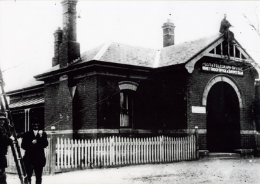 Sunbury Family History and Heritage Society Inc.
Photograph, c 1900s
The building is the Sunbury Post and Telegraph Office and residence, which was built on the corner of Brook and Evans Street in 1892. Prior to that time the postal service ion Sunbury was conducted at the railway station. Over the years changes and extensions have taken place to the building to accommodate it for modern postal delivery practices although it still operates from the same site.The Sunbury Post Office has operated in a building on the same site since 1892 despite many changes and extensions made to the building, which included the demolition of the residence attached to the original building.A black and white photograph of Victorian style brick building with a slate roof with 3 chimneys and surrounded by a white picket fence. Two men are standing by a ladder on the LHS of the image. sunbury, sunbury post office, post and telegraph offices -
 Sunbury Family History and Heritage Society Inc.
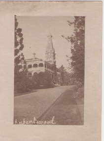
Photograph
Rupertswood Mansion was the Sunbury residence of the Clarke family from 1874 until 1922 when H.V.McKay of Sunshine Harvester fame bought it from Hon. W.L. Russell Clarke in 1922. After the death of H.V.McKay in 1926, it was purchased by W. Naughton who then sold the mansion and 700 acres of land to the Salesian Fathers, who are the present owners. It is now the site of Salesian College, a Catholic co-educational college fore secondary students.Rupertswood Mansion has had close social, spiritual and educational links with Sunbury's development since 1874.A small sepia photograph with a cream frame of a driveway leading to a large mansion. 'RUPERTSWOOD' written in the LH corner of the photograph.rupertswood mansion, clarke, w.j.t., mckay, h.v., salesian college