Showing 272 items
matching bendigo area map
-
 Bendigo Historical Society Inc.
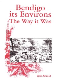
Book - BENDIGO ITS ENVIRONS THE WAY IT WAS, 2003
Bendigo its Environs The way it Was. A brief history of Bendigo & surrounding areas & of the water supply and railway line to Bendigo & surrounds. Contains 432 pages with photographs, illustrations and maps, published by Crown Castleton.Ken Arnoldbendigo, history, bendigo & district, signed by author, limited edition number 175 -
 Bendigo Historical Society Inc.
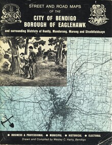
Book - STREET AND ROAD MAPS OF THE CITY OF BENDIGO BOROUGH OF EAGLEHAWK, c1980
Street and Road Maps of the City of Bendigo Borough of Eaglehawk and surrounding Districts of Huntly, Mandurang, Marong and Strathfieldsaye, in color. Drawn and compiled by Wesley C Harry, Bendigo. Publisher: Cambridge Press, Bendigo. ISBN: 9598608.2.2. 68 pages. Photographs, Illustrations & maps. Photos include: Bendigo buildings, scenery mines, streetscapes, parades, pioneer leaders of Bendigo. Many advertisements throughout. List of Justices of the Peace, hospitals, homes for the aged, schools, churches. Page 58: Copy of ''Freedom of the City to the Australian Survey Regiment'' proclamation, 14th June 1970. Maps cover an area of some 169 sq. miles (43,772 hectares). Origin of the name Bendigo. Information on the five Wards of Bendigo, and their councilors.Wesley C Harrybook, bendigo, bendigo & district maps, bendigo and districts map, buildings, streetscapes, historical pictures, advertisements, historical information, commisioners camp, sandhurst -
 Bendigo Historical Society Inc.
Book - BENDIGO THE GOLDEN AGE RETRACED, 1973
Bendigo the golden age retraced Front cover is a map of the area using white lines to point out points of interest in Bendigo. These places are then described in brief detail throught the book. There are also illustrations of each place of interest. Part A has a signature inside the front cover dated 1973. b, has a photo of 'Sun Loong' in front of the Shamrock Hotel, at easter time. This is in a plastic folder which is then inside a folded card, with adrawing of the old Town Hall on the front. C, has a library sticker on the lower spine, numbered 0035 nei. With Index. 64 pages.Jan Neilbendigo, buildings, effects of gold in bendigo., . -
 Bendigo Historical Society Inc.
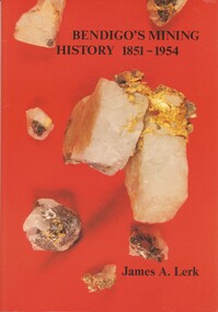
Book - BENDIGO'S MINING HISTORY 1851 - 1954, 1991
Bendigo's Mining History 1851 - 1954. Introduction and overview of gold and mining by the pioneers in the Bendigo area. Contains photographs, Illustrations and Maps. Page 1 has a letter of thanks from James Lerk to the Bendigo Historical Society for use of material in their collection. Autographed by author on 22 July 1991James A. Lerkhistory, mining -
 Bendigo Historical Society Inc.
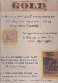
Document - 'GOLD' POSTER WITH DESCRIPTION OF NUGGETS
Poster heading - 'Gold' - 'In the whole world, only 47 nuggets weighing over 30lbs Troy have been recorded. Of these 40 are from Australia. The region from Ballarat around to Bendigo yielded 32 of these large nuggets. This monument erected in 1897 by the Mines Department, is the only one ever erected to honour the discovery of a gold nugget. The 'Welcome Stranger' nugget was unearthed on 5th February, 1869, weighing 2316 ounces and it was sold for 9.553 pounds'. Poster includes a map of Victoria depicting the main gold mining areas, also mention of gypsum, and tin in northern Victoria. A photo of the monument to the discovery of the 'Welcome Stranger' nugget found 1 1/4 miles from Moliagul in the bottom corner.document, gold -
 Bendigo Historical Society Inc.
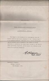
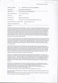
Document - REPORT ON THE BENDIGO GOLDFIELD, EDWARD DYASON
Grey cover document, 21 typed pages with map of goldfield appended. On front page 'Report on the Bendigo Goldfield Central Area. This report is the outcome of an investigation into the present condition and future prospects of the Central Area of the Bendigo goldfield, undertaken with a view to seeing what improved methods could be adopted in the conduct of mining operations to neutralise the recent heavy increase in the cost of labour and mining requisites, and so restore the industry to the level of its previous prosperity' Signed by E.C. Dyason, B.Sc. B.M.E., Commonwealth Chambers, Bendigo, Victoria, 15th November, 1918.bendigo, gold mining, report on goldfield, bendigo goldfield, goldmining, mining companies, reef lines, underground workings, e.c. dyason -
 Bendigo Historical Society Inc.
Map - BENDIGO HISTORICAL SOCIETY COLLECTION: EAGLEHAWK MINE MAP
Base map Australian map grid of Eaglehawk area. Map has letter attached from the Department of Conservation, Forests and Lands, 22 March, 1990, addressed to Felicity Kingerlie, BHS, requesting information regarding the historic mining sites marked on the map. Sites marked are: A. Golden Age Mine, engine mountings present B. Johnson's No. 2 Mine, engine mountings, old boiler foundations C. Johnson's No. 1 Mine, mullock retaining wall made from sandstone, engine mountings, remains of old building demolished? D. Toma's Eucalyptus Factory, old boiler still there, boiler shed, chimney (remnants of) outlet drain, distilling vats, dam, remnant of winch. E. New Argus Mine,mullock heap F. New Moon Mines Dams (1) stone walls G. North Lightning Hill Mine, engine mountings, quartz retainer wall, Pascoe and Simmons open cuts and other open cuts here too H. New Prince of Wales Mine and Poppet Head I. Quarry site for stone, excavation (for miners cottages in Clarke Street) J. Lancashire open cut mine K. Virginia Hill (cynaide vats etc) L. South Prince of Wales mine, now capped and fenced M (possibly ) Catherine United Mine, engine mountings, battery mountings?bendigo, mining, eaglehawk mines -
Bendigo Historical Society Inc.
Book - BENDIGO SUB-REGIONAL STRATEGY PLAN 1980
141 page soft cover spiral bound booklet 'Bendigo Sub-Regional Strategy Plan - September 1980' Areas covered , City of Bendigo, Borough of Eaglehawk, Shires of Huntly, Marong and Strathfieldsaye. Maps included.Bendigo Sub-Regional Committee -
Bendigo Historical Society Inc.
Document - CERTIFICATE OF TITLE MCKENZIE STREET
Certificate of title under the transfer of land act 1890. Vol.3219 fol.643627. James Dunlop Boyd medical practitioner and Annie Sophia Boyd married woman, both of McKenzie Street Bendigo areas tenants in common the proprietors of an estate in fee simple, subject to the encumbrances notified hereunder in all this piece of land delineated and colored red on the map in the margin being part of crown allotment fourteen section two B city of Bendigo, together with a right of carriageway over the road colored brown on the said map. Dated the fourteenth day of August 1907.buildings, commercial, mckenzie street -
Bendigo Historical Society Inc.
Book - REPORT ON THE NORTH CENTRAL STUDY AREA OF VICTORIA
252 page Report on the North Central Study Area by the Land Conservation Council of Victoria - July 1978 Illustrated with B&W photos Back section contains several removeable maps. Printed by F D Atkinson, Government Printer, MelbourneLand Conservation Council, Victoria -
 Bendigo Historical Society Inc.
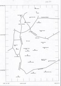
Document - CENTRAL DEBORAH GOLD MINE : GOLDEN SQUARE MINE SITES
Map showing mines in the Golden Square, Diamond Hill area. Roads include Diamond Hill Road, Burns Street, Woodward Road, Belle Vue Road, Houston Street. Latitude and Longitude on map.bendigo, mining, golden square mine sites -
 Bendigo Historical Society Inc.
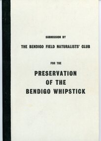
Document - PETER ELLIS COLLECTION: SUBMISSION BY THE BENDIGO FIELD NATURALIST CLUB FOR THE PRESERVATION OF THE WHIPSTICK 1971, 1971
PETER ELLIS COLLECTION: Submission by The Bendigo Field Naturalist Club for the Preservation of the Whipstick Bendigo 1971 The submission was sent to the Minister for Forests. 'On behalf of the Bendigo Field Naturalist's Club, we, the President and Honorary Secretary, make application to the Forests Commission to have two areas, as approximately shown in green on the maps submitted (under separate cover), and being in the parishes of Huntly Nerring and Whirakee, Edgerton declared as Forest Parks under the Appropriate Act.' The Submission has the following contents: Bendigo's Claim for a Forest Park or National Park The Proposed Foiorest Parks Near Bendigo The Flora of The Proposed Whipstick Forest Park Species of Native Plants Bendigo Whipstick Area 1971 Species of Birds Bendigo Whipstick Area 1971 Mammals of the Whipstick Historical Bendigo Whipstick Statisticsperson, individual, peter ellis oam -
 Bendigo Historical Society Inc.
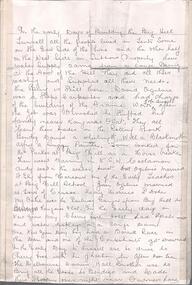
Document - BIG HILL TUNNEL DESCRIPTION
Description of the Big Hill Tunnel, why it was built and David Ogilvie who worked on it with a detailed map of the area.bendigo, planning, big hill tunnel -
 Bendigo Historical Society Inc.
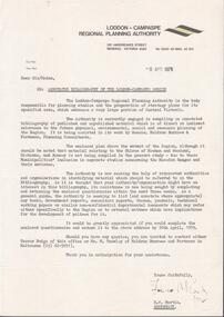
Document - LODDON - CAMPASPE REGIONAL PLANNING AUTHORITY LETTER
Two letters from the Loddon - Campaspe Regional Planning Authority the first dated 9th April, 1979 the second 12th April, 1979 both titled: annotated bibliograpghy of the Loddon-Campaspe Region. Also a map of the Loddon-Campaspe regional Autorithy area of study. Two stapled pages of the Annotated Bibliography of the Loddon - Campaspe Regionorganisation, government, loddon campaspe -
 Bendigo Historical Society Inc.
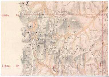
Map - DIAMOND HILL AREA
Copy of map of Diamond Hill area, with the Trig Station mid centre on map. Shafts, mines and geological features are marked.bendigo, mining, diamond hill -
 Bendigo Historical Society Inc.
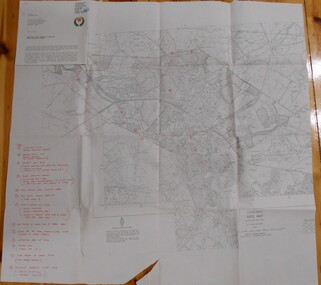
Document - DIAMOND HILL AREA MAP
Map copy, 2 pages, from 'Old Mines Department Plan, Dept of Conservation and Environment File No W91006, 16.6.1972' Map shows Golden Gully area with 'Town and Country Hotel' on north side and further south, with shafts and mine names marked.bendigo, mining, diamond hill -
 Bendigo Historical Society Inc.
Document - GOLDEN GULLY ALLUVIAL WORKINGS
Golden Gully alluvial workings, Diamond Hill area, site number 1.1. Document has map/grid references, parcel number and location - runs along Woodward Road. History from 1851 to 186 detailed. . Information from David Bannear's Bendigo goldfields survey. -
 Bendigo Historical Society Inc.
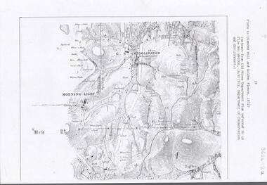
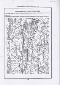
Document - DIAMOND HILL, GOLDEN GULLY COSERVATION AREA
Map of Golden Gully conservation area comprising Glasgow and Golconda Consolidated, Glasgow Reef Company (Golden Gully) and New Napoleon. The area is significant because it contains the 'best evidence for hydraulic sluicing on the field as well as several early reef mining sites' On top of page 'Eaglehawk & Bendigo Heritage Study, Significant areas' Mines marked on page: Goldfields Extended shaft South Concord shaft Concord shaft Morning Light shaft Hansel and Mundy shaftbendigo, mining, golden gully -
Bendigo Historical Society Inc.
Document - DIAMOND HILL HISTORIC AREA PARKS VICTORIA
Document, two pages, prepared by Parks Victoria in relation to the Diamond Hill Historic Area. Contains information regarding the history of the area; German Miners; Plants and animals. On second page is a map of the area showing historic features: Deborah Consolidated Gold workings Red, White and Blue Extended gold workings Goldfields Extended gold workings Dead Dog Gully, alluvial gold workings Glasgow & Golconda Gold workings and tramway Surface gold mining site Hansel Mundy gold workings Bendigo Goldfields Pty gold workings Stafford gold workings Langdon gold workings Great Opossum Gully alluvial gold workingsbendigo, mining, diamond hill -
 Bendigo Historical Society Inc.
Document - STATE RIVERS AND WATER SUPPLY COMMISSION VICTORIA : CENTRAL PLANT WORKSHOPS
State Rivers and Water Supply Commission of Victoria. Brochure titled 'Central Plant Workshops'. Double-sided, three pages on each. Information about the workshops (CPW for short) and the setting up of the Bendigo site from 1946. There is a map of the layout of the site, and information given under the following headings - Central Plant Workshops, Work of the CPW, Meter Wheels, Pump Station Equipment, Steel Fabrication, Precast Concrete, and the Area and its Equipment. The brochure is dated June, 1968.state infrastructure, water supply, coliban system, state rivers and water supply commission of victoria. coliban system. central plant workshops. -
 Bendigo Historical Society Inc.
Book - WHO DISCOVERED BENDIGO GOLD, 2009
Who discovered Bendigo gold? A new look at the 1890 select committee report, 65 pages with maps and black & white photographs, published by the Australian Institute of Genealogical Studies Inc, Bendigo area.David Horsfallbendigo, history, early digging days, bendigo-history-gold discovery- henry frenchman -
 Bendigo Historical Society Inc.
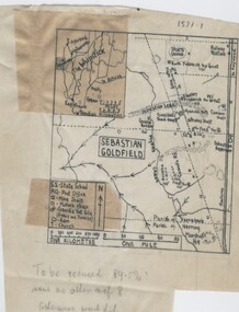
Negative - TOM PATULLO COLLECTION: SEBASTIAN GOLDFIELD
Negative,/Hand drawn of the goldfield featuring gold mine sites,cyanide vats,heaps,railway station,sports ground. A small map of the Whipstick area, and legend. Tom Patullo was formerly of Clear-Ads Bendigo.cottage, miners, sebastian goldfield, sebastian goldfield -
 Bendigo Historical Society Inc.
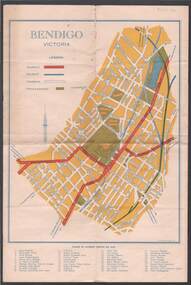
Map - BILL ASHMAN COLLECTION: MAP OF BENDIGO
... of Interest marked, Map of the Bendigo Area with Places of Interest... - Correspondence Map of Bendigo Cambridge Press A R McConnachie Bendigo ...Map of Bendigo. Contains street of Bendigo with Places of Interest marked, Map of the Bendigo Area with Places of Interest marked, and on the centre page is Bendigo the Golden Gateway to the North. There is a map with circles around Bendigo and their distance from centre Bendigo. Circles go to a distance of 20 miles. Information includes General Information, Scenic Attractions, Industrial Activities, Industries already Established, Sporting Facilities - Bendigo and District, and Cultural Organizations. JCI shield on the left under the map. Also some brief information about Bendigo.sciences, instruments - general, scalebuoy, bill ashman collection - correspondence, map of bendigo, cambridge press, a r mcconnachie, bendigo junior chamber of commerce, bendigo city council -
 Bendigo Historical Society Inc.
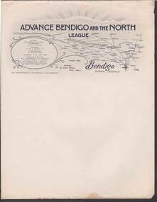
Document - CAMBRIDGE PRESS COLLECTION: LETTERHEAD - ADVANCE BENDIGO AND THE NORTH LEAGUE
Advance Bendigo and the North League, Allan's Walk, Pall Mall, Bendigo. Letterhead printed in dark blue and grey. At the top are sun rays above a cloud? On the right it has a map showing Bendigo and a large area to the North, North East and North West. On the left is an oval shape with the names of the Patron, His Worship the Mayor of Bendigo Cr. W. H. Taylor, President: Cr. G. D. Garvin, J.P., Vice-President W. Cowling, Esq, Executive Committee, Cr. J. Michelsen, J. L. Shoosmith, Cr. W. H. Taylor, J. Jeffrey, Dr. A. Beischer, C. L. Stilwell,A. L. Bolton O.B.E., W. Wallace, Lt. Col. G. V. Lansell, M.L.C.business, printers, cambridge press, cambridge press collection, advance bendigo and the north league, cr w h taylor, cr g d garvin j.p., w cowling, c m dawe, cr j michelsen, j l shoosmith, cr w h taylor, j jeffrey, dr a beischer, c l stillwell, a l bolton o.b.e., w wallace, lt col g v lansell m.l.c. -
 Bendigo Historical Society Inc.
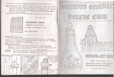
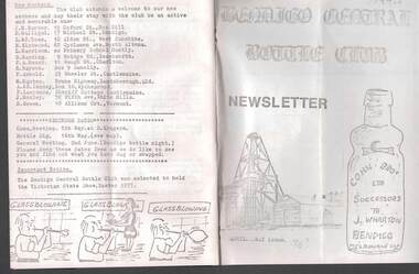
Document - JAMES LERK COLLECTION: BENDIGO CENTRAL BOTTLE CLUB NEWSLETTER
Bendigo Central Bottle Club Newsletter - James Lerk Collection (June /July 1976). Article on ''Old Inglewood'' (by Ken Arnold) - information on 1858 - 1860s with sketch map of gullies in area; Reference to bottle of T R Jones, Chemist of Bendigo (Pall Mall, near Allans Walk); list of some other bottle manufacturers in Bendigo. -
 Bendigo Historical Society Inc.
Document - JAMES LERK COLLECTION: BENDIGO CENTRAL BOTTLE CLUB NEWSLETTER
Bendigo Central Bottle Club Newsletter - James Lerk Collection (April 1976 by deduction). Reference to William Brude store owner/wine and spirit merchant. Involved in partnership in London Brewery and owned Norfolk Brewery - includes list of various bottles owned and used by William Bruce. Reference to Sheepwash being once a main thoroughfare to Bendigo (with sketch map) and information on two of the seven vineyards in area by 1855 - A. Derivan (sic) De Ravin and William Jones, Wine Merchant; article on Bendigo Breweries - reference in it to Albion Brewery, Phoenix Brewery (Pheonix sic), Lucan St Brewery, Thunder & Co, Thunders Sandhurst Brewery, A Thunder & Co, Tankard Malting Co, Bendigo Cognac Distilling Coy, Norfolk Brewery, BB Brewery, Union Brewery, Dublin Porter Brewery, Hindmarsh Brewery, Liverpool Brewery, Edinborough Brewery, Adelaide Brewery, the City Brewing Co, Anchor Brewing Co, Kent Brewery, Alpine Brewery, Sandhurst Brewery; Page listing know Bendigo aerated water manufacturers who used the Hamilton Patent - W Bruce, J Heffernam (sic) ,Hefferman?, G Pritchard, Hunter Bros, J Wharton, F G Beard, A Phillips, T Davies. -
 Bendigo Historical Society Inc.
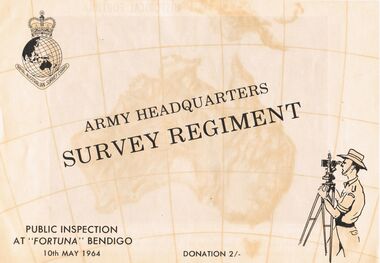
Document - ARMY HEADQUARTERS SURVEY REGIMENT, BENDIGO, 10 May, 1964
Army Headquarters Survey Regiment, Bendigo. Public Inspection at 'Fortuna', 10 May 1964. Donation 2/-. Includes photos of the Entrance Hall, Music Room and Villa. 3 army photos. In 1942 the mansion was occupied by the Australian Survey Corps and 'Fortuna' became the site of the base map production plant of the Australian Army for the remainder of the war years. During this period approximately sixteen million maps of Australian Territories and theatres of operation in the South West Pacific Area, were produced for use by the Allied Services. This function was continued as a peace time role in the post war years, and in 1951 ''Fortuna'' was purchased by the Commonwealth Government. As the largest unit of the Royal Australian Survey Corps, AHQ Survey Regiment carries out mapping in all parts of the Commonwealth and Territories including Papua and New Guinea. The Regiment is not only capable of doing its own field surveys but is responsible for the drawing and printing of map compilations from Royal Australian Survey Corps units in all States. . . . Includes map of grounds.buildings, residential, fortuna villa, army headquarters survey regiment, bendigo. public inspection at 'fortuna', 1964. photos of the entrance hall, music room and villa. mansion was occupied by australian survey corps and 'fortuna' site of the base map production plant australian army war. sixteen million maps australian territories and theatres of operation in the south west pacific area, were produced for use by the allied services. 1951 ''fortuna'' was purchased by the commonwealth government. royal australian survey corps, ahq survey regiment mapping commonwealth and territories including papua and new guinea. royal australian survey corps units in all states. map of grounds -
Bendigo Historical Society Inc.
Map - CAMPBELL COLLECTION: BENDIGO AND DISTRICT MAPS, 1982
Map. Forest Commission Victoria, Bendigo Forest District, Sub-Plan 1 District Fire Prevention Plan, Greater Bendigo Area. Prevention Strategy Plan. Shire of Marong, Shire of Huntly, Borough of Eaglehawk, Shire of Strathfieldsaye, Sailors Gully, Epsom, Jackass Flat, White Hills, California Gully, Maiden Gully, Long Gully, North Bendigo, City of Bendigo, Bendigo East, Kennington, West Bendigo, Golden Square, Quarry Hill, Flora Hill, Spring Gully, Kangaroo Flat.Base prepared 1982. (number 397 in map cupboard 1)map, bendigo, forest district -
Bendigo Historical Society Inc.
Map - CAMPBELL COLLECTION: BENDIGO AND DISTRICT MAPS, 10-5-29
Map. Mandurang, Scale 20 chains to an inch. Total area 5746 acres. Kennington, Township of Mandurang. To accompany my report of 10-5-29 R. Marshall, Forest assessor. Drawn by I.M.K. (number 399 in map cupboard 1)I.M.K.map, bendigo, allotments -
Bendigo Historical Society Inc.
Map - CAMPBELL COLLECTION: BENDIGO AND DISTRICT MAPS, 6-4-28
Map. Sedgwick, Parishes of Strathfieldsaye, Lyell, and Sedgwick. Scale 20 chains to 1 inch. Total area 5372 acres. Prepared in W.P.B. from C.L.and A. Plans by W.J.Galbraith 6-4-28. (number 400 in map cupboard 1)W.J.Galbraith.map, bendigo, agricultural lands