Showing 494 items
matching building lots
-
 Eltham District Historical Society Inc
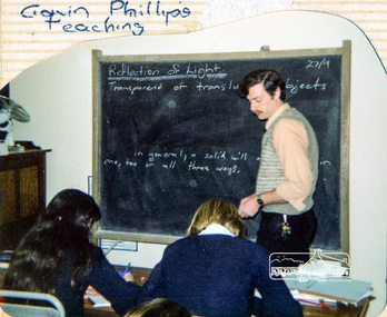
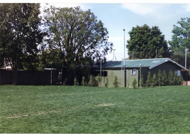
Photograph, Gavin Phillips teaching, Eltham Christian School, 1982, 1982
Gavin Phillips teaching, Eltham Christian School, 1982 The Stokes family settled in this area of Eltham in the 1940s and were associated with the Eltham Christian Church. In the 1970s this church had met in temporary premises in Eltham. Lots of the original 1920s subdivision remained south of Nyora Road and a number of these lots were utilized for the Eltham Christian School, which was established by the Eltham Christian Church in 1981. The school operated on this site until 2000. The premises were owned by the Nillumbik Community Church who were in operation till November 2010 when the Eltham Baptist Church commenced a lease arrangement until the site was purchased by them in April 2012. The building is constructed of brick and timber with a balcony on two sides that looks over an expanse of grass. Sources: STOKES ORCHARD – AN INCOMPLETE HISTORY February 28, 2015 http://www.elthamhistory.org.au/ Australian Christian Church Histories - Eltham Baptist Church http://www.churchhistories.net.au/church-catalog/eltham-vic-baptist/ From an album featuring a series of photographs (some cropped) from a magnetic photo album relating to the staff, students and activities of the Eltham Christian School which operated as part of the Eltham Christian Church at Nyora Road, Eltham. See also entries for each photograph.colour photographeltham christian school, nyora road, gavin phillips, teaching -
 Eltham District Historical Society Inc
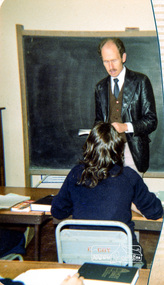
Photograph, Pastor Chris Trinham, Eltham Christian School, 1982, 1982
Pastor Chris Trinham, Eltham Christian School, 1982 The Stokes family settled in this area of Eltham in the 1940s and were associated with the Eltham Christian Church. In the 1970s this church had met in temporary premises in Eltham. Lots of the original 1920s subdivision remained south of Nyora Road and a number of these lots were utilized for the Eltham Christian School, which was established by the Eltham Christian Church in 1981. The school operated on this site until 2000. The premises were owned by the Nillumbik Community Church who were in operation till November 2010 when the Eltham Baptist Church commenced a lease arrangement until the site was purchased by them in April 2012. The building is constructed of brick and timber with a balcony on two sides that looks over an expanse of grass. Sources: STOKES ORCHARD – AN INCOMPLETE HISTORY February 28, 2015 http://www.elthamhistory.org.au/ Australian Christian Church Histories - Eltham Baptist Church http://www.churchhistories.net.au/church-catalog/eltham-vic-baptist/ From an album featuring a series of photographs (some cropped) from a magnetic photo album relating to the staff, students and activities of the Eltham Christian School which operated as part of the Eltham Christian Church at Nyora Road, Eltham. See also entries for each photograph.colour photographeltham christian school, nyora road, teaching, chris trinham -
 Eltham District Historical Society Inc
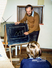
Photograph, Len Whalley, primary and secondary photography elective, Eltham Christian School, 1982, 1982
Len Whalley, primary and secondary photography elective, Eltham Christian School, 1982 The Stokes family settled in this area of Eltham in the 1940s and were associated with the Eltham Christian Church. In the 1970s this church had met in temporary premises in Eltham. Lots of the original 1920s subdivision remained south of Nyora Road and a number of these lots were utilized for the Eltham Christian School, which was established by the Eltham Christian Church in 1981. The school operated on this site until 2000. The premises were owned by the Nillumbik Community Church who were in operation till November 2010 when the Eltham Baptist Church commenced a lease arrangement until the site was purchased by them in April 2012. The building is constructed of brick and timber with a balcony on two sides that looks over an expanse of grass. Sources: STOKES ORCHARD – AN INCOMPLETE HISTORY February 28, 2015 http://www.elthamhistory.org.au/ Australian Christian Church Histories - Eltham Baptist Church http://www.churchhistories.net.au/church-catalog/eltham-vic-baptist/ From an album featuring a series of photographs (some cropped) from a magnetic photo album relating to the staff, students and activities of the Eltham Christian School which operated as part of the Eltham Christian Church at Nyora Road, Eltham. See also entries for each photograph.colour photographeltham christian school, nyora road, teaching, len whalley -
 Eltham District Historical Society Inc
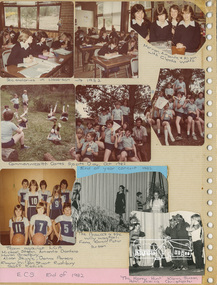
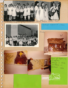
Photo Album page, Photo album, Eltham Christian School, Nyora Road, Eltham 1981-1984, 1982
Photo album, Eltham Christian School, Nyora Road, Eltham 1981-1984 The Stokes family settled in this area of Eltham in the 1940s and were associated with the Eltham Christian Church. In the 1970s this church had met in temporary premises in Eltham. Lots of the original 1920s subdivision remained south of Nyora Road and a number of these lots were utilized for the Eltham Christian School, which was established by the Eltham Christian Church in 1981. The school operated on this site until 2000. The premises were owned by the Nillumbik Community Church who were in operation till November 2010 when the Eltham Baptist Church commenced a lease arrangement until the site was purchased by them in April 2012. The building is constructed of brick and timber with a balcony on two sides that looks over an expanse of grass. Sources: STOKES ORCHARD – AN INCOMPLETE HISTORY February 28, 2015 http://www.elthamhistory.org.au/ Australian Christian Church Histories - Eltham Baptist Church http://www.churchhistories.net.au/church-catalog/eltham-vic-baptist/ From an album featuring a series of photographs (some cropped) from a magnetic photo album relating to the staff, students and activities of the Eltham Christian School which operated as part of the Eltham Christian Church at Nyora Road, Eltham. See also entries for each photograph.Page from magnetic photo album with colour photographs (some cropped) with captionseltham christian school, nyora road -
 Eltham District Historical Society Inc
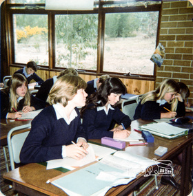
Photograph, Secondaries in classroom, Eltham Christian School, 1982, 1982
Secondaries in classroom, Eltham Christian School, 1982 The Stokes family settled in this area of Eltham in the 1940s and were associated with the Eltham Christian Church. In the 1970s this church had met in temporary premises in Eltham. Lots of the original 1920s subdivision remained south of Nyora Road and a number of these lots were utilized for the Eltham Christian School, which was established by the Eltham Christian Church in 1981. The school operated on this site until 2000. The premises were owned by the Nillumbik Community Church who were in operation till November 2010 when the Eltham Baptist Church commenced a lease arrangement until the site was purchased by them in April 2012. The building is constructed of brick and timber with a balcony on two sides that looks over an expanse of grass. Sources: STOKES ORCHARD – AN INCOMPLETE HISTORY February 28, 2015 http://www.elthamhistory.org.au/ Australian Christian Church Histories - Eltham Baptist Church http://www.churchhistories.net.au/church-catalog/eltham-vic-baptist/ From an album featuring a series of photographs (some cropped) from a magnetic photo album relating to the staff, students and activities of the Eltham Christian School which operated as part of the Eltham Christian Church at Nyora Road, Eltham. See also entries for each photograph.2 Colour photographseltham christian school, nyora road, classroom -
 Eltham District Historical Society Inc
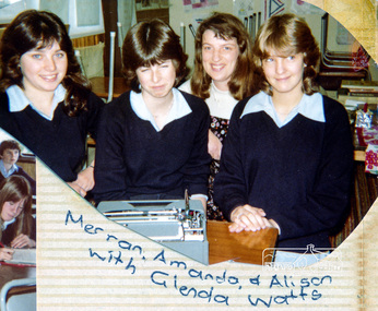
Photograph, Merrin Bradbury, Amanda Doedens, Alison Skingle with Glenda Watts, Eltham Christian School, 1982, 1982
Merrin Bradbury, Amanda Doedens, Alison Skingle with Glenda Watts, Eltham Christian School, 1982 The Stokes family settled in this area of Eltham in the 1940s and were associated with the Eltham Christian Church. In the 1970s this church had met in temporary premises in Eltham. Lots of the original 1920s subdivision remained south of Nyora Road and a number of these lots were utilized for the Eltham Christian School, which was established by the Eltham Christian Church in 1981. The school operated on this site until 2000. The premises were owned by the Nillumbik Community Church who were in operation till November 2010 when the Eltham Baptist Church commenced a lease arrangement until the site was purchased by them in April 2012. The building is constructed of brick and timber with a balcony on two sides that looks over an expanse of grass. Sources: STOKES ORCHARD – AN INCOMPLETE HISTORY February 28, 2015 http://www.elthamhistory.org.au/ Australian Christian Church Histories - Eltham Baptist Church http://www.churchhistories.net.au/church-catalog/eltham-vic-baptist/ From an album featuring a series of photographs (some cropped) from a magnetic photo album relating to the staff, students and activities of the Eltham Christian School which operated as part of the Eltham Christian Church at Nyora Road, Eltham. See also entries for each photograph.colour photographeltham christian school, nyora road, merrin bradbury, amanda doedens, alison skingle, glenda watts -
 Eltham District Historical Society Inc
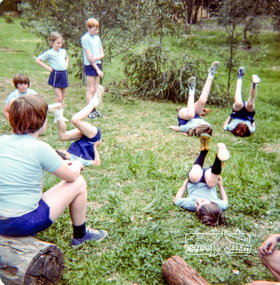
Photograph, Commonwealth Games Sports Day, Eltham Christian School, October 1982, 1982
Commonwealth Games Sports Day, Eltham Christian School, October 1982. Students doing exercises and showing off their awards. The Stokes family settled in this area of Eltham in the 1940s and were associated with the Eltham Christian Church. In the 1970s this church had met in temporary premises in Eltham. Lots of the original 1920s subdivision remained south of Nyora Road and a number of these lots were utilized for the Eltham Christian School, which was established by the Eltham Christian Church in 1981. The school operated on this site until 2000. The premises were owned by the Nillumbik Community Church who were in operation till November 2010 when the Eltham Baptist Church commenced a lease arrangement until the site was purchased by them in April 2012. The building is constructed of brick and timber with a balcony on two sides that looks over an expanse of grass. Sources: STOKES ORCHARD – AN INCOMPLETE HISTORY February 28, 2015 http://www.elthamhistory.org.au/ Australian Christian Church Histories - Eltham Baptist Church http://www.churchhistories.net.au/church-catalog/eltham-vic-baptist/ From an album featuring a series of photographs (some cropped) from a magnetic photo album relating to the staff, students and activities of the Eltham Christian School which operated as part of the Eltham Christian Church at Nyora Road, Eltham. See also entries for each photograph.3 colour photographseltham christian school, nyora road, sport -
 Eltham District Historical Society Inc
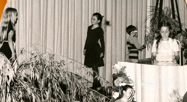
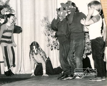
Photograph, End of year concert, “The Peacock and the Willy Wagtail”; Fiona Berry, Karen Whalley, Peter Whalley, Susan Field, Eltham Christian School, 1982, 1982
End of year concert, “The Peacock and the Willy Wagtail”; Fiona Berry, Karen Whalley, Peter Whalley, Susan Field, Eltham Christian School, 1982 The Stokes family settled in this area of Eltham in the 1940s and were associated with the Eltham Christian Church. In the 1970s this church had met in temporary premises in Eltham. Lots of the original 1920s subdivision remained south of Nyora Road and a number of these lots were utilized for the Eltham Christian School, which was established by the Eltham Christian Church in 1981. The school operated on this site until 2000. The premises were owned by the Nillumbik Community Church who were in operation till November 2010 when the Eltham Baptist Church commenced a lease arrangement until the site was purchased by them in April 2012. The building is constructed of brick and timber with a balcony on two sides that looks over an expanse of grass. Sources: STOKES ORCHARD – AN INCOMPLETE HISTORY February 28, 2015 http://www.elthamhistory.org.au/ Australian Christian Church Histories - Eltham Baptist Church http://www.churchhistories.net.au/church-catalog/eltham-vic-baptist/ From an album featuring a series of photographs (some cropped) from a magnetic photo album relating to the staff, students and activities of the Eltham Christian School which operated as part of the Eltham Christian Church at Nyora Road, Eltham. See also entries for each photograph.black and white photographeltham christian school, nyora road, concert, fiona berry, karen whalley, peter whalley, susan field, the peacock and the willy wagtail -
 Eltham District Historical Society Inc
Photograph, End of year concert, “The Honey Hunt”; Karen Whalley, Susan Field, Peter Whalley, Jessica Doedens, Christopher Field, Eltham Christian School, 1982, 1982
End of year concert, “The Honey Hunt”; Karen Whalley, Susan Field, Peter Whalley, Jessica Doedens, Christopher Field, Eltham Christian School, 1982 The Stokes family settled in this area of Eltham in the 1940s and were associated with the Eltham Christian Church. In the 1970s this church had met in temporary premises in Eltham. Lots of the original 1920s subdivision remained south of Nyora Road and a number of these lots were utilized for the Eltham Christian School, which was established by the Eltham Christian Church in 1981. The school operated on this site until 2000. The premises were owned by the Nillumbik Community Church who were in operation till November 2010 when the Eltham Baptist Church commenced a lease arrangement until the site was purchased by them in April 2012. The building is constructed of brick and timber with a balcony on two sides that looks over an expanse of grass. Sources: STOKES ORCHARD – AN INCOMPLETE HISTORY February 28, 2015 http://www.elthamhistory.org.au/ Australian Christian Church Histories - Eltham Baptist Church http://www.churchhistories.net.au/church-catalog/eltham-vic-baptist/ From an album featuring a series of photographs (some cropped) from a magnetic photo album relating to the staff, students and activities of the Eltham Christian School which operated as part of the Eltham Christian Church at Nyora Road, Eltham. See also entries for each photograph.black and white photographeltham christian school, nyora road, concert, karen whalley, susan field, peter whalley, jessica doedens, christopher field, the honey hunt -
 Eltham District Historical Society Inc
Photo Album page, Photo Album Eltham Christian School, Nyora Road, Eltham, 1981-1984, 1982
The Stokes family settled in this area of Eltham in the 1940s and were associated with the Eltham Christian Church. In the 1970s this church had met in temporary premises in Eltham. Lots of the original 1920s subdivision remained south of Nyora Road and a number of these lots were utilized for the Eltham Christian School, which was established by the Eltham Christian Church in 1981. The school operated on this site until 2000. The premises were owned by the Nillumbik Community Church who were in operation till November 2010 when the Eltham Baptist Church commenced a lease arrangement until the site was purchased by them in April 2012. The building is constructed of brick and timber with a balcony on two sides that looks over an expanse of grass. Sources: STOKES ORCHARD – AN INCOMPLETE HISTORY February 28, 2015 http://www.elthamhistory.org.au/ Australian Christian Church Histories - Eltham Baptist Church http://www.churchhistories.net.au/church-catalog/eltham-vic-baptist/ From an album featuring a series of photographs (some cropped) from a magnetic photo album relating to the staff, students and activities of the Eltham Christian School which operated as part of the Eltham Christian Church at Nyora Road, Eltham. See also entries for each photograph.page from magnetic photo album with photographs and captionseltham christian school, nyora road -
 Eltham District Historical Society Inc
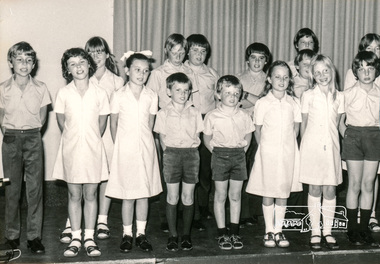
Photograph, School Concert, Primary Singing Group, Eltham Christian School, 1982, 1982
School Concert, Primary Singing Group, Eltham Christian School, 1982 The Stokes family settled in this area of Eltham in the 1940s and were associated with the Eltham Christian Church. In the 1970s this church had met in temporary premises in Eltham. Lots of the original 1920s subdivision remained south of Nyora Road and a number of these lots were utilized for the Eltham Christian School, which was established by the Eltham Christian Church in 1981. The school operated on this site until 2000. The premises were owned by the Nillumbik Community Church who were in operation till November 2010 when the Eltham Baptist Church commenced a lease arrangement until the site was purchased by them in April 2012. The building is constructed of brick and timber with a balcony on two sides that looks over an expanse of grass. Sources: STOKES ORCHARD – AN INCOMPLETE HISTORY February 28, 2015 http://www.elthamhistory.org.au/ Australian Christian Church Histories - Eltham Baptist Church http://www.churchhistories.net.au/church-catalog/eltham-vic-baptist/ From an album featuring a series of photographs (some cropped) from a magnetic photo album relating to the staff, students and activities of the Eltham Christian School which operated as part of the Eltham Christian Church at Nyora Road, Eltham. See also entries for each photograph.black and white photographeltham christian school, nyora road, concert -
 Eltham District Historical Society Inc
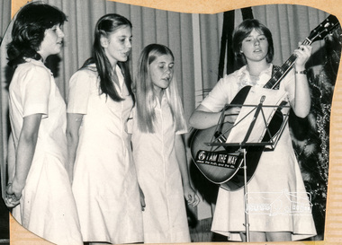
Photograph, School Concert, Merrin Bradbury, Sonya Illingworth, Colleen McCoy, Helen Morrow, Eltham Christian School, 1982, 1982
School Concert, Merrin Bradbury, Sonya Illingworth, Colleen McCoy, Helen Morrow, Eltham Christian School, 1982 The Stokes family settled in this area of Eltham in the 1940s and were associated with the Eltham Christian Church. In the 1970s this church had met in temporary premises in Eltham. Lots of the original 1920s subdivision remained south of Nyora Road and a number of these lots were utilized for the Eltham Christian School, which was established by the Eltham Christian Church in 1981. The school operated on this site until 2000. The premises were owned by the Nillumbik Community Church who were in operation till November 2010 when the Eltham Baptist Church commenced a lease arrangement until the site was purchased by them in April 2012. The building is constructed of brick and timber with a balcony on two sides that looks over an expanse of grass. Sources: STOKES ORCHARD – AN INCOMPLETE HISTORY February 28, 2015 http://www.elthamhistory.org.au/ Australian Christian Church Histories - Eltham Baptist Church http://www.churchhistories.net.au/church-catalog/eltham-vic-baptist/ From an album featuring a series of photographs (some cropped) from a magnetic photo album relating to the staff, students and activities of the Eltham Christian School which operated as part of the Eltham Christian Church at Nyora Road, Eltham. See also entries for each photograph.black and white photographeltham christian school, nyora road, concert, merrin bradbury, sonya illingworth, colleen mccoy, helen morrow -
 Kiewa Valley Historical Society
Alex McCullough Collection - Notes and Photos on History of Mt Beauty
Alex McCullough was a resident of Mt Beauty for many years and wrote a book on the History of Mt Beauty. Mt Beauty was constructed by the State Electricity Commission of Victoria to house employees working on the Kiewa Hydro Electric Scheme. Alex was involved with many organisations in Mt Beauty and interested in history. He took many photos of events and new developments in town. He also collected individuals memoirs on life in the town.Mt Beauty's history is unique as it was built as a construction town in the late 1940s. The information in Alex's Collection records the town's development perhaps in more detail than in his book "The History of Mt Beauty". His folder includes his education, his work with the SECV (foreman working on Clover Dam), his war service, his community work (Mt Beauty & District Progress Association & Mt Beauty Neighbourhood Centre) and awards, work as Shire Councillor and Mayor, sporting (tennis & golf) interests. Alexander John McCullough 1916 - 2011's obituary is online ref. legacy.comA) Booklet - The Life of Alex McCullough B) Booklet - The Story of Kiewa by Alex McCullough C) Coloured photos 15cm x 10 cm of the renovation of the Mt Beauty Neighbourhood Centre mid 2001. Four photos are labelled by Alex McCullough on the back. Also, photos of various sizes both colored and black and white depicting sites and people in Mt Beauty. Not labelled.Also, six packets of negatives of older photos incl. Community Hall, Fire Brigade, School, School ski group, Back to Kiewa, Alpine Study, D) Alex McCulloughs 1951 Diary - Clover Dam E) Random Items from History Profile Kiewa by Alex McCullough F) Papers - 'Administration of Mt Beauty Township' - 2nd July 1957. SECV buildings in Mt Beauty shared with community groups notes re - arrangement between groups. G) Barrie Wilcox's Memories living in Marum's paddock from c1940s onwards. Written in June 1999 H) Mt Beauty website June 1998 - a lot of history I) Papers - Mt Beauty High School band developement J) The 1950s Development of the Birth of Community support organisations K) Community Centre Mt Beauty opening 3rd August 1951 L) Mt Beauty Fire Brigade History M) Folder Personal papers re Alex McCullough alex mccullough, mt beauty history, community work -
 4th/19th Prince of Wales's Light Horse Regiment Unit History Room
Photograph, Verdun, c 1918
A black & white photograph showing a brick house with a semi-collapsed roof. There is a lot of damage around the building . On the back: "In a deep excavation under this house the Crown Prince watched the battle of Verdun - a camera obscura having been obstructed with lens and periscope up the chimney. The house had been bought by a German some years before the war."photo, verdun, camera obscura -
 Eltham District Historical Society Inc
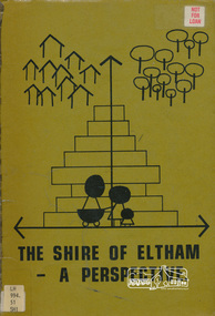
Book, Shire of Eltham, The Shire of Eltham - A Perspective, July 1981
This report was produced by the Shire of Eltham (Planning Department) following a population study of the Shire. It also includes other areas of general interest. The Document contents includes Present and Future - Population - Housing - Residential Lands - Social Characteristics - Development and History. Includes maps, tables and diagrams. Part 1: The Existing situation - introduction, the Shire of Eltham, physical characteristics, historical development, population growth. Characteristics of the population - size and distribution, age / sex, natural increase, migration. Socio-Economic Factors: socio-economic status, employment/workforce, education, other social factors. Housing/ building statistics: characteristics of Housing stock, current residential trends, other types of building activity. Residential Land: existing vacant lots, estimated additional lots. Part 2: The Future. Land availability, the future population.The Shire of Eltham Council resolved on publication of this report "to commend it to the ratepayers as a most valuable resource document". It provides a comprehensive statistical review of the Shire of Eltham, Victoria in 1981 with some population and development predictions for the future.Spiral bound, soft cover, includes indexBarcode and identification markings including stamped "WITHDRAWN" from Heidelberg Regional Library Serviceshire of eltham, planning, population -
 Eltham District Historical Society Inc
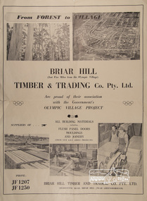
Poster, Briar Hill Timber & Trading Co. Pty. Ltd, c.1956
Advertisement insert in The Age newspaper around the opening of the 1956 Olympic Games promoting Briar Hill Timber's association with the Olympic Village Project being suppliers of all building materials including Flush Panel Doors, Mouldings and Joinery. Briar Hill Timber owned by F. Squire and the Squire family owned a lot of land around Briar Hill and land for forest at Flowerdale. Operations ranged from logging of trees, to milling to manufacture of joinery and housing frames.Poster approximately A2 in sizebriar hill timber, f. squire, olympic village, 1956 olympic games, timber mill, flowerdale, briar hill, h.v. plowman, logging, advertisement -
 Ringwood and District Historical Society
Flyer, Stillwell & Stephens Pty. Ltd, Brochure - Multiple Properties for Public Auction at Box Hill, Ringwood, Wonga Park and Clarinda - 28th November, 1934
Seven-page brochure advertising Mortgagees' Realising Sale by Public Auction on Wednesday, 28th November, 1934 for properties at Box Hill, Ringwood, Wonga Park, and Clarinda (via Oakleigh), including photographs, property descriptions, and terms of sale.Auction Commencing at 2.15 p.m. in the Orient Line Auction Rooms, 352 Collins Street, Melbourne. Solicitors: Messrs. Madden, Butler, Elder & Graham, 406 Collins Street, Melbourne. (Agents) H.P. Knight & Co. Property Salesmen and Subidivisional Experts, 315 Collins Street, Melbourne, 'Phones: Central 10615, 10616. Attractive Residential, Orchard, and Market Garden Properties, and Public Hall and School Rooms. 1. Wonga Park via Ringwood - "Holme Bush" off Warrandyte Road, Part of Lots 14 and 15, Ringwood Orchard Estate, approximatgely three miles (north) of Ringwood Railway Station - 64 Acres. 2. 17 Bishop Street, Box Hill - timber residence. 3. Greenwood Avenue, Ringwood - On East Side, 150 feet 3 inches South of Bedford Road - timber attic residence. 4. Ringwood - Wantirna Road, South-east corner of Canterbury Road - Orchard Property of approx. 11-1/2 Acres. 5. Box Hill - Whitehorse Road, South-east corner of Linsley Street - Timber building utilised as a Public Hall and Private School. 6. Clarinda vic Oakleigh, Talbot Crescent, off Centre Road - Home on 10 acres of land. -
 Ringwood and District Historical Society
Pamphlet, G.A. Green, Auction Sale Brochure - Garden Farms Estate, Ringwood, Victoria - 1919, 1919
Multi-fold brochure advertising public auction of one-acre, 2-acre, 5-acre and 8-acre allotments in Ringwood and Bayswater on Saturday 12th April, 1919. Brochure includes terms of sale, description of subdivision features and local facilities, and photographic images of the area.Subdivison includes Canterbury Road Heathmont, Armstrong Road Heathmont, Armstrong Road Bayswater, Bungalook Road Heathmont, Bungalook Road Bayswater, and Orchard Road Bayswater. Road shown as Bayswater Road to Bayswater became Mountain Highway Bayswater. Vendor: H.E.B.Armstrong, Auctioneers: Coghill & Haughton, 79 Swanston Street Melbourne, Telephone Central 2793, in conjunction with J.B. McAlpin, Ringwood, Opposite Station, Telephone Ringwood 7. (Map) Woodcock & McCormack, Civil Engineers Architects & Surveyors, 430 Little Collins Street, Melbourne, Phone 3241 Central. MOST OF THE MONEY COMES OUT OF THE LAND. And more money can be obtained from anb acre of fruit than from an acre of any other produce. But you do not have to grow fruit on Garden Farms Estate. You can go in for - Outer Suburban Home - Market Garden - Orchard - Pig Raising - Poultry Farm - Small Dairy Farm - Small Fruits - Floral Culture - Scent and Bee Farm - Or just for a Week-end Home. RINGWOOD - THE PLACE TO LIVE. The Beautiful Ringwood District has so many natural attractions, that half a Land Agent's work is done in just showing a prospective buyer round and about. Ringwood has a pull of its own that attracts folk, proved beyond doubt by its rapid development within the last decade (spite the war). First, it is high and healthy, picturesque and undulating, convenient of access, sufficiently close to the Metropolis for City and Business folk to live at Ringwood. Its development is solid, because most of its people are industrious husbandmen, real producers, who have turned idle hills into smiling gardens. These are the kind of real people to live amongst; ones who wear out their spades. The rapidly-developing town has excellent Stores, Trade and Repair Shops Churches, Banks, Telephone Exchange, Weekly General Market, Cool Stores, and good Private and State Schools, etc.; is Electrically lit, has Metropolitan Water Supply, and generally provides so that practically all shopping can be done locally. WHY RINGWOOD MUST GROW. Ringwood is a great centre and must be a greater. Two rapidly-developing railways junction here. The passengers from Ringwood Station cityward, in one year, number 250,000. Ringwood will be the terminus of the Outer Suburban Electric Eastern Railway. Its natural boundaries are the River Yarra on the North, Dandenong Creek on the South, the popular town of Croydon on the East, and the suburb of Mitcham on the West. This is a large territory that is steadily being converted from intense culture, and then it might be called (as regards its gardens) "The Devon Territory of Victoria." ARMSTRONG ROAD. This new road traverses Garden Farms Estate from its northern boundary on the main Canterbury Road, across Dandenong Creek, to its southern boundary on the main Bayswater Road, and will provide a long-desired additional link of communication between Bayswater and Ringwood. The 1-acre building sites on Bayswater Road are within 8 minutes' walk of the Bayswater Railway Station, and the Canterbury Road frontages are only 1-1/2 miles from Ringwood Station, and 1/2 mile from the Railway Station site of Canterbury Road; therefore, the whole Estate is easy of access and there should be a large demand for land so favourably placed. (Image) Cultivation Field - Potatoes on Lot 28 (Image) Picture of Bayswater Creek Flats. (Image) View from "Korumbeen" where Mr. Armstrong lived on Garden Farms Estate. Estate outlined in white ring. (Image) Site of New Bridge over Dandenong Creek. (Image) On one of the timbered lots adjoining railway. (Image) This Dandenong Creek traveres the Estate. (Image) Main Fern Tree Gully Line bisects the Estate. -
 Ringwood and District Historical Society
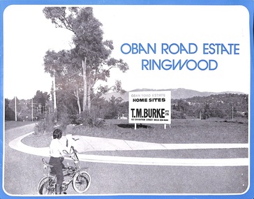
Flyer, Land Sale Advertisement, Oban Road Estate, Ringwood, Vic. - 1974
Double-sided folded page with blue border advertising sale of Oban Road Estate Ringwood building allotments. Front page features photograph of view from the estate towards Dandenong Ranges. Centrefold pages include terms of sale, layout and features of the subdivision, and summary of local services. Photocopy of typewritten price list for the 52 lots also attached.Subdivision includes Oban Road, Ambrie Avenue, Hendra Grove, and Mullum Mullum Road. (Agent) T.M. Burke Pty Ltd., 63 Exhibition Street Melbourne, Telephone 654 4144. -
 Ringwood and District Historical Society
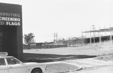
Photograph, Construction work at Target Square, NE corner of Maroondah Hwy and New Street, Ringwood - 1981, 1981
Two views of Target Square shopping complex building under construction.Written on back of photographs - V134a "29-6-81 View from Verstegen's no - New St across Brambles lot at the centre of Target building cnr of Charters-New St on right below Target." - V134b "30-6-81. Looking south from Brambles across Charter St. west end of Target. New St. just out of picture right". -
 Glen Eira Historical Society
Photograph, Dalny Road, 5-17 Rear, Murrumbeena, 2001
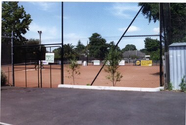
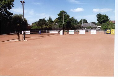
Originally labelled "Beauville Estate, Established 1936, Still Thriving 65 years on, 10th March 2001", the Beauville Estate Album contains colour photographs of houses in the Estate. They were taken around the time of the Beauville Estate’s 65th Heritage Celebration held on 10/03/2001 and donated to the Caulfield Historical Society shortly afterwards. Photographer unknown. From Glen Eira’s Heritage Management Plan by Andrew Ward (1996) Vol 2 p78: "Beauville Avenue is unusual in that it is terminated in a cul-de-sac (see Section 3.9.2) whilst the design of the estate may well be unique for its time in that the houses back onto 6 tennis courts for public use. St. Patrick's Church, which adjoins the estate is a comparatively recent structure whilst the school has one building erected in 1930 and prior to the release of the Beauville lots." It also notes that St.Patrick's Church and School now run the tennis courts. The Beauville Historic Area is important at the State level as the first large housing estate undertaken by the AV Jennings Construction Co, later Jennings Group Limited, Victoria’s largest home builder. It is important also as a very early estate development incorporating a range of features other than houses and including made roads, shops and recreation facilities. In this respect it was the forerunner of the comprehensively planned housing estate of the post war era. The estate is distinguished by its aesthetic values, as is the earlier and comparable Hillcrest Estate, which are formed by a combination of restrained diversity in house styles, with the exception of no. 30 in the emerging International style, and by a landscaped garden environment. See Significance Statement in Glen Eira’s Heritage Management Plan by Andrew Ward (1996) Vol 2 p.79. Available from https://www.gleneira.vic.gov.au/media/4779/heritage_management_plan_volume_2.pdf (Note see p.84 of pdf)Colour photograph of a playground on the Beauville Estate. murrumbeena, houses, 1930's, a.v. jennings, av jennings, jennings, beauville estate, playgrounds, parks and reserves, sir albert victor jennings, a v jennings construction co, beauville estate heritage area, glen eira city council, jennings group limited, land subdivision, gardens, beauville historic area, st patrick's church, st patrick's school, dalny road -
 Glen Eira Historical Society
Photograph, Dalny Road, 5-17 Rear, Murrumbeena, 2001
Originally labelled "Beauville Estate, Established 1936, Still Thriving 65 years on, 10th March 2001", the Beauville Estate Album contains colour photographs of houses in the Estate. They were taken around the time of the Beauville Estate’s 65th Heritage Celebration held on 10/03/2001 and donated to the Caulfield Historical Society shortly afterwards. Photographer unknown. From Glen Eira’s Heritage Management Plan by Andrew Ward (1996) Vol 2 p78: "Beauville Avenue is unusual in that it is terminated in a cul-de-sac (see Section 3.9.2) whilst the design of the estate may well be unique for its time in that the houses back onto 6 tennis courts for public use. St. Patrick's Church, which adjoins the estate is a comparatively recent structure whilst the school has one building erected in 1930 and prior to the release of the Beauville lots." It also notes that St.Patrick's Church and School now run the tennis courts.City of Glen Eira’s Heritage Management Plan Vol 2 p79 (this is p84 of the pdf version) – HO12 Beauville Estate and environs, Murrumbeena: The Beauville Historic Area is important at the State level as the first large housing estate undertaken by the AV Jennings Construction Co, later Jennings Group Limited, Victoria’s largest home builder. It is important also as a very early estate development incorporating a range of features other than houses and including made roads, shops and recreation facilities. In this respect it was the forerunner of the comprehensively planned housing estate of the post war era. The estate is distinguished by its aesthetic values, as is the earlier and comparable Hillcrest Estate, which are formed by a combination of restrained diversity in house styles, with the exception of no. 30 in the emerging International style, and by a landscaped garden environment. Colour photograph of a tennis club house and a park on the Beauville Estate. murrumbeena, houses, 1930's, a.v. jennings, av jennings, jennings, beauville estate, jennings albert victor, parks and reserves, sports and recreations establishments, clubhouses, tennis clubs, beauville tennis courts, st patrick's tennis club, sir albert victor jennings, a v jennings construction co, beauville estate heritage area, glen eira city council, architectural features, jennings group limited, land subdivision, gardens, beauville historic area, dalny road -
 Glen Eira Historical Society
Photograph, Dalny Road, 5-17 Rear, Murrumbeena, 2001
Originally labelled "Beauville Estate, Established 1936, Still Thriving 65 years on, 10th March 2001", the Beauville Estate Album contains colour photographs of houses in the Estate. They were taken around the time of the Beauville Estate’s 65th Heritage Celebration held on 10/03/2001 and donated to the Caulfield Historical Society shortly afterwards. Photographer unknown. From Glen Eira’s Heritage Management Plan by Andrew Ward (1996) Vol 2 p78: "Beauville Avenue is unusual in that it is terminated in a cul-de-sac (see Section 3.9.2) whilst the design of the estate may well be unique for its time in that the houses back onto 6 tennis courts for public use. St. Patrick's Church, which adjoins the estate is a comparatively recent structure whilst the school has one building erected in 1930 and prior to the release of the Beauville lots." It also notes that St.Patrick's Church and School now run the tennis courts.City of Glen Eira’s Heritage Management Plan Vol 2 p79 (this is p84 of the pdf version) – HO12 Beauville Estate and environs, Murrumbeena: The Beauville Historic Area is important at the State level as the first large housing estate undertaken by the AV Jennings Construction Co, later Jennings Group Limited, Victoria’s largest home builder. It is important also as a very early estate development incorporating a range of features other than houses and including made roads, shops and recreation facilities. In this respect it was the forerunner of the comprehensively planned housing estate of the post war era. The estate is distinguished by its aesthetic values, as is the earlier and comparable Hillcrest Estate, which are formed by a combination of restrained diversity in house styles, with the exception of no. 30 in the emerging International style, and by a landscaped garden environment. Colour photograph of tennis courts and surrounding mesh fencing on the Beauville Estate. murrumbeena, houses, 1930's, a.v. jennings, av jennings, jennings, beauville estate, parks and reserves, sports and recreations establishments, tennis courts, sportsgrounds, sir albert victor jennings, a v jennings construction co, beauville estate heritage area, glen eira city council, architectural features, jennings group limited, land subdivision, gardens, beauville historic area, tennis clubs, beauville tennis courts, st patrick's tennis club, dalny road -
 Glen Eira Historical Society
Photograph, Dalny Road, 5-17 Rear, Murrumbeena, 2001
Originally labelled "Beauville Estate, Established 1936, Still Thriving 65 years on, 10th March 2001", the Beauville Estate Album contains colour photographs of houses in the Estate. They were taken around the time of the Beauville Estate’s 65th Heritage Celebration held on 10/03/2001 and donated to the Caulfield Historical Society shortly afterwards. Photographer unknown. From Glen Eira’s Heritage Management Plan by Andrew Ward (1996) Vol 2 p78: "Beauville Avenue is unusual in that it is terminated in a cul-de-sac (see Section 3.9.2) whilst the design of the estate may well be unique for its time in that the houses back onto 6 tennis courts for public use. St. Patrick's Church, which adjoins the estate is a comparatively recent structure whilst the school has one building erected in 1930 and prior to the release of the Beauville lots." It also notes that St.Patrick's Church and School now run the tennis courts. City of Glen Eira’s Heritage Management Plan Vol 2 p79 (this is p84 of the pdf version) – HO12 Beauville Estate and environs, Murrumbeena: The Beauville Historic Area is important at the State level as the first large housing estate undertaken by the AV Jennings Construction Co, later Jennings Group Limited, Victoria’s largest home builder. It is important also as a very early estate development incorporating a range of features other than houses and including made roads, shops and recreation facilities. In this respect it was the forerunner of the comprehensively planned housing estate of the post war era. The estate is distinguished by its aesthetic values, as is the earlier and comparable Hillcrest Estate, which are formed by a combination of restrained diversity in house styles, with the exception of no. 30 in the emerging International style, and by a landscaped garden environment. Colour photograph of tennis courts with lights on the Beauville Estate. murrumbeena, houses, 1930's, a.v. jennings, av jennings, jennings, beauville estate, parks and reserves, sports and recreations establishments, tennis courts, sportsgrounds, sir albert victor jennings, a v jennings construction co, beauville estate heritage area, glen eira city council, architectural features, jennings group limited, land subdivision, gardens, beauville historic area, tennis clubs, beauville tennis courts, st patrick's tennis club, dalny road -
 Glen Eira Historical Society
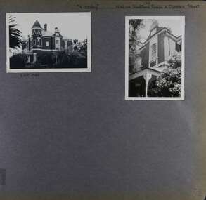
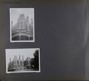
Album - Album page, Eversley, Gladstone Parade & Clarence Street, Circa 1972
This photograph is part of the Caulfield Historical Album 1972. This album was created in approximately 1972 as part of a project by the Caulfield Historical Society to assist in identifying buildings worthy of preservation. The album is related to a Survey the Caulfield Historical Society developed in collaboration with the National Trust of Australia (Victoria) and Caulfield City Council to identify historic buildings within the City of Caulfield that warranted the protection of a National Trust Classification. Principal photographer thought to be Trevor Hart, member of Caulfield Historical Society. Most photographs were taken between 1966-1972 with a small number of photographs being older and from unknown sources. All photographs are black and white except where stated, with 386 photographs over 198 pages. Property now known as Eversley, formerly Nulmore then Brampton. From Caulfield Heritage Management Plan 1996 by Andrew Ward In 1888, C. Hume owned lots 61, 62 and 63 in the Kooyong Park Estate, on the northwest corner of Gladstone Parade and Clarence Street. In 1889 Thomas B. Jackson, architect, of Shoobra Road, purchased the land and in the same year built a ten roomed brick house on lot 63 and part lot 62. Jackson leased the property to William Dalrymple in 1890. By 1894, the property was owned by P. Langwill and leased to James Ainslie, an accountant. By 1899, Frederick Henriques had moved into the house, which was known as ''Nulmore". In 1910, the house was vacant. In 1920, it was leased to Augustine Barbeta who continued to live there in 1930. By 1934, the house was renamed ''Brampton". ''Nulmore" is locally important as an unusually imposing Elizabethan influenced villa in Caulfield, comparing with nos. 34 and 25 Gladstone Parade. Its link with local architect Thomas B Jackson is of interest. Page 52 of Photograph Album with two exterior photographs (one landscape and one portrait) of Eversley , a double storey mansion.Hand written: (36 )[top right] / "Eversley" N.W. cnr Gladstone Parade & Clarence Street [top right] / 8 Oct 1966 [under top left photo] / 52 [bottom right] trevor hart, 1880's, 1890's, gladstone parade, eversley, victorian, clarence street, architectural features, nulmore, brampton, kooyong park estate, architect, shoobra road, hume, elsternwick, double storey mansions, thomas b jackson, william dalrymple, p langwill, james ainslie, frederick henriques, augustine barbeta, elizabethan style, house names -
 Glen Eira Historical Society
Album - Album page, Gladstone Parade, 34, Circa 1972
This photograph is part of the Caulfield Historical Album 1972. This album was created in approximately 1972 as part of a project by the Caulfield Historical Society to assist in identifying buildings worthy of preservation. The album is related to a Survey the Caulfield Historical Society developed in collaboration with the National Trust of Australia (Victoria) and Caulfield City Council to identify historic buildings within the City of Caulfield that warranted the protection of a National Trust Classification. Principal photographer thought to be Trevor Hart, member of Caulfield Historical Society. Most photographs were taken between 1966-1972 with a small number of photographs being older and from unknown sources. All photographs are black and white except where stated, with 386 photographs over 198 pages. From Caulfield Heritage Management Plan 1996 by Andrew Ward In 1889, Thomas B Jackson, an architect in Shoobra Road, owned lots 61-63 at the north west intersection with Clarence Street. He built the two red brick houses, each of 10 rooms, known as "Kenly" and "Nulmore" (later "Brampton") in that year. By 1894, P. Langwill had purchased the property, leasing it to Fred Henriques, an accountant. Alfred Pearson a government chemist, was occupying tenant by 1899. The property was known as ''Kenly''. In 1910, the house was vacant, however, in 1920, James Edmends was living there and continued to do so in 1930. By 1941, Edmends had moved to No. 32, and Alfred Williamson was in residence. "Kenly'' is important as an unusually imposing Elizabethan influenced villa in Caulfield, comparing with nos. 25 and 36 Gladstone Parade. Its importance is enhanced by its substantially intact state whilst its link with local architect Thomas B Jackson is of interest.Page 53 of Photograph Album with two exterior photographs (one portrait and one landscape) of a double storey brick mansion.Hand written: 34 Gladstone Parade [top left] / 53 [bottom left] trevor hart, 1880's, 1890's, gladstone parade, eversley, victorian, double storey, clarence street, architectural features, nulmore, brampton, kooyong park estate, architect, shoobra road, elsternwick, kenly, elizabethan influence, thomas b jackson, p langwill, fred henriques, alfred pearson, james edmends, alfred wiliamson, house names -
 Glen Eira Historical Society
Album - Album page, Glen Huntly Road, Circa 1972
This photograph is part of the Caulfield Historical Album 1972. This album was created in approximately 1972 as part of a project by the Caulfield Historical Society to assist in identifying buildings worthy of preservation. The album is related to a Survey the Caulfield Historical Society developed in collaboration with the National Trust of Australia (Victoria) and Caulfield City Council to identify historic buildings within the City of Caulfield that warranted the protection of a National Trust Classification. Principal photographer thought to be Trevor Hart, member of Caulfield Historical Society. Most photographs were taken between 1966-1972 with a small number of photographs being older and from unknown sources. All photographs are black and white except where stated, with 386 photographs over 198 pages. From: Glen Eira Heritage Management Plan (1996) by Andrew Ward and Associates Moore's Buildings", were built in 1891 and comprising 5 shops. In 1888, Hugh Moore, a gentleman, subdivided his land in Glen Huntly Road, north side between Selwyn Street and St Georges Road into 27 lots, with a right of way separating them from his property "Glenmoore". The subdivision was known as the "Glenmoore Estate". Purchases of land included local builders Corkill, French and Pugh. Moore retained five lots and W.W. Jamieson bought lots 11 to 14. "Moore' s Buildings are locally important for their association with the early Elsternwick land owner, Hugh Moore, whose home, "Glenmoore", at 1 St.Georges Road (qv) survives. They recall Elsternwick's role in the Land Boom and survive as a most prominent row in the Glen Huntly Road shops, enhanced by the survival of the unpainted stuccoed surfaces to nos. 307-311. 287-289 Glen Huntly Road: contributory to HO72, Elsternwick Estate and Environs, City of Glen Eira.Page 63 of Photograph Album with one landscape photograph of retail shops (Moore's Buildings).Hand written: 287-289 Glen Huntly Road [under photo] / 63 [bottom left] trevor hart, shop, grocer, stuccoed, terrace, victorian terrace, protruding parapet, ornate render, hugh moore, 1890's, moore's buildings, glenmoore, glenmoore estate, shopping centres, milk bars, cars, victorian style, glen huntly road, glenhuntly road, elsternwick -
 Glen Eira Historical Society
Album - Album page, Booran Road, 30, Circa 1972
This photograph is part of the Caulfield Historical Album 1972. This album was created in approximately 1972 as part of a project by the Caulfield Historical Society to assist in identifying buildings worthy of preservation. The album is related to a Survey the Caulfield Historical Society developed in collaboration with the National Trust of Australia (Victoria) and Caulfield City Council to identify historic buildings within the City of Caulfield that warranted the protection of a National Trust Classification. Principal photographer thought to be Trevor Hart, member of Caulfield Historical Society. Most photographs were taken between 1966-1972 with a small number of photographs being older and from unknown sources. All photographs are black and white except where stated, with 386 photographs over 198 pages. From Glen Eira Heritage Management Plan 1996 by Andrew Ward: In 1888, John Leek, a trainer, owned Lot 15, measuring one and three quarter acres, in Booran Road, north side between Glen Eira and Neerim Roads. The land backed onto the Caulfield Racecourse Reserve. NAV was £45. In 1890 Leek built for his residence, a ten roomed brick house on the site. NAV was £200. Leek was the owner/trainer of "Ingliston" who won the Caulfield Cup in 1900. Upon the horse's death in 1901, Leek is understood to have defied tradition by spending £20 on boots for the "ragged urchins in Bourke Street" instead of "shouting" at the bar. By 1899, the property was owned and occupied by Alfred Merrill, a dentist and was known as "Andover". NA V had decreased to £ll0. By 1910, Leslie Macdonald, a gentleman had purchased the property and renamed it "Moidart". In 1910-11 Macdonald sold it to John Robertson. The property had extensive wood stables on its north-east boundary and several other outbuildings. The house continued to be described as "Brick, ten rooms" as it was in 1926 when it was owned and occupied by John Arthur, a managing director. The land measured la.2r.31p. and had a NAV of £235. Nine people lived there. In 1926, Arthur also owned the adjoining Lot 16. Other racehorses of note, known to have been stabled here include Sobar, Havelock, Proud, Future and Lord.Victorian Heritage Register https://vhd.heritagecouncil.vic.gov.au/places/13532 What is significant? Lord Lodge is a thoroughbred racehorse training complex adjacent to Caulfield Racecourse, established in 1890. The area immediately around the racecourse has been associated with horse racing activities and businesses servicing the industry since the development of the racecourse in late the 19th century. Lord Lodge was named by the present occupants after the champion racehorse Lord who was stabled there in the 1950s. In the early 20th century the property was known as 'Andover' and subsequently 'Moidart'. The site consists of a single storey brick Italianate villa, jockeys' quarters, stables and open day yards with direct access to Caulfield racecourse from the rear of the property. The villa of 10 rooms on bluestone foundations was constructed in 1890 by John Leek, a horse trainer who purchased the newly subdivided land in 1888. The house has many Victorian Italianate or Boom Style features although it is more modest than many villas of its style. It has an asymmetrical facade with a faceted bay window and a prominent central tower with low pitch pyramidal roof that provides a clear view of the racecourse. Other characteristic features include stilted segmented arches, bracketed eaves, stucco wall finish and cast cement ornamentation. A room has been added on the north-facing verandah in sympathetic style and finish. Internally the rooms are substantially intact with original marble fireplaces and intricate ceiling roses and cornices. An entrance toward the rear of the southern side of the house is said to be where the stable hands, jockeys and other staff lined up for their meals. In the southeast corner of the property, backing directly on to Caulfield racecourse, is a substantial late Victorian timber stable, probably constructed in the 1890s but first appearing on the property title in 1910. The stable has 12 stalls, a loft and brick pavement and jerkin head roof form with varnished pine-lined ceiling carried on a chamfered timber frame. It has an original roof lantern. The doors of the stalls are not the original sliding doors but swing doors obtained from a barn at Epsom Racecourse in Mordialloc prior to demolition. Outside the gambrel roof has fretted barges but the building is otherwise utilitarian. Timber throughout the stalls has been worn by chewing and rubbing of horses over the century of its use. In the southern half of the property are open day yards where the racehorses are kept during the day. The red brick, single storey jockeys' quarters to the rear of the villa were probably built around 1950. A small brick, possibly late Victorian structure on the eastern boundary thought to have originally been a gardening shed, has been converted to a stable of two stalls. Modern concrete brick stables fill the northeast portion of the property. At the front of the property two Moreton Bay Figs (Ficus macrophylla), probably planted in the late 19th century, provide shade for horses in the day yards. In the 1890s John Leek sold the property, relocating his training facility to one of the newly established racecourses at Mentone or Mordialloc (Epsom). By 1899, the property was owned and occupied by Alfred Merrill, a dentist, who named the property 'Andover'. In 1910 it was purchased by Leslie McDonald, a gentleman, and renamed 'Moidart'; sold in 1910-1911 to John Robertson; and again in 1926 to John Arthur, a racehorse owner. The Victorian Amateur Turf Club purchased the property in the late 1930s and since this time has been leased to racehorse trainers. It is unclear whether the property operated as a training facility between 1899 - 1926. Several notable trainers and jockeys are associated with Lord Lodge. The best known is Arthur 'Scobie' Breasley, Australia's most successful jockey who was apprenticed to trainer Pat Quinlan at Lord Lodge (then 'Moidart') from 1928 - 1935. Breasley rode winners of the Caulfield Cup in four successive years 1942-45 and again in 1952. John Leek, the original owner of Lord Lodge trained Ingliston, the 1900 Caulfield Cup winner. Along with 'Lord' a number of well known racehorses including Sobar, Havelock, Proud and Future were trained at Lord Lodge .....Page 40 of Photograph Album with three landscape photographs of the exterior of this house.Handwritten: 30 Booran Road [top right hand corner] / 40 [bottom right]trevor hart, jenny o'donnell, booran road, mansion, caulfield east, ingliston, sobar, havelock, proud, future, lord, andover, moidart, lord lodge, grace darling, caulfield racecourse reserve, victorian amateur turf club, historic buildings register, national estate register, caulfield cup, horses, stables, horse racing, racehorses, outbuildings, racehorse trainers, depression, 1890s, brick houses, mansions, towers, verandahs, stained glass, italianate style, victorian style, architectural features, architectural styles, john leek, leslie macdonald, john arthur, john robertson, alfred merrill, jenny odonnell -
 Flagstaff Hill Maritime Museum and Village
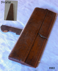
Tool - Moulding Plane, 1770-1809
The story of Christopher Gabriel born on April 2, 1746, in Falmouth England is a tale of a poor boy who made good. Shortly before he turned thirteen years of age in 1759 he was apprenticed to a local master carpenter, recorded as a Mr Barnicot the master trained his apprentice well as we can assume by Christopher's later successes. The apprenticeship ended in 1766 after seven years when Christopher reached twenty. Then in 1768, he relocated to London walking the two hundred miles from Falmouth carrying his possessions in a sack. He no sooner arrived in London when he met Alice Trowell who became his wife in March 1769. They set up house on Albermarie Street Clerkenwell and by the first of 1770, Gabriel had begun his business of plane making. It has been speculated that Gabriel took over the shop of John Cogdell aided with an investment from his in-laws of 131 pounds. He went on to prosper as a plane-maker and lumber merchant over the next forty years. His business did well and in 1774 Gabriel moved to a house in Golden Lane, London and 1779 moved again to a home in Ould Street London. By now Gabriel was making a name for himself and his business at this time was located at 32 Banner Street Golden Lane, the following year he purchased another home in Banner Street and 1793 purchased the house next door. At the time of his death in 1808, he owned twenty-seven houses and commercial building. Christopher Gabriel s descendants became quite prominent in England and his grandson, Sir Thomas Gabriel became the Sheriff of London and Middlesex in 1859 and the Lord Mayor of London 1866 and 1867. Gabriel was an extremely prolific plane-maker with a lot of examples made in the 18th century can still be found today. He made good quality tools and was an innovator of several new plane designs. A vintage tool made by a well-known plane-maker, this item was made commercially for firms and individuals that worked in wood and needed a tool that could give a decorative finish to timber. These planes came in various shapes and sizes to achieve a finish to timber surfaces and came in many sizes. A significant Christopher Gabriel plane from the mid to late 18th century that after 200 years can still be used today. Planes made by Gabriel are eagerly sought after by collectors. The tool gives us a snapshot of how furniture and other finishes were created on timber by the use of cutting edged hand tools. Tools that were themselves hand made shows the craftsmanship used during this time not only to make a tool such as the subject item but also the craftsmanship needed to produce a decorative or even finish that was needed for the finishing of timber items. Side Rabbet Plane Stamped Maker Gabriel (owner M Hobling).flagstaff hill, warrnambool, shipwrecked-coast, flagstaff-hill, flagstaff-hill-maritime-museum, maritime-museum, shipwreck-coast, flagstaff-hill-maritime-village, side rabbet plane, gabriel m hobling -
 Ringwood and District Historical Society
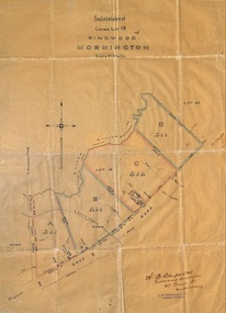
Plan, Subdivision of Crown Lot 19, Ringwood, Victoria - circa 1915
Surveyor's map on wax paperSubdivision map includes Mullum Creek, Government Road to Anderson's Creek, later Warrandyte Road, Government Road to Lillydale, later Whitehorse Road, small creek bridge, later Sandy Creek at Ringwood Lake. Buildings marked include Roman Catholic Church, O.J. Pratt's House and Pratt's butcher shop (photos attached). Map by A.B. Bruford & Co., Licensed Surveyor, 47 Queen Street, Melbourne.