Showing 431 items
matching central and east
-
 Ballarat Tramway Museum
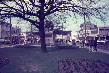
Slide - 35mm slide/s - set of 3, Dave Simpson, trams at the intersection of Sturt and Lydiard St - City terminus, late 1960's early 1970's
Yields information about the intersection of Sturt and Lydiard Sts tramway centre and Boer War monument.Set of three 35mm slides - AGFA dark blue / white plastic mounts of trams at the intersection of Sturt and Lydiard St - City terminus. 1 - view from the central median on the west side of Lydiard St, looking East with the Commonwealth Bank, Post Office, with many passengers at the location. The Boer War monument /statue is in the centre part of the photograph. 2 - No. 14 about to turn into Lydiard St North/ The short tram stop and End of Section sign are adjacent to the tram. 3 - Tram waiting at the north side tram stop - has a Twin Lakes and Cinzano sign. Has the ANZ bank and the SEC offices in the background.tramways, trams, sturt st, city, lydiard st, passengers, signs, tram 14 -
 Surrey Hills Historical Society Collection
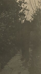
Photograph, David Miller Mair, 20 Barton Street
David Miller (Dave) Mair (1879-1938) married Lily Vipond Deakin (1890-1945) in 1910. They had 5 children: Geoffrey David (1913-1970), Beryl (1916-1976), Gwynneth (1917-1997), Isabel Lillian (1921-1997) and Shirley Inez (1928-1968). His parents were Isabella Brown (1856-1944) and William Mair (1850-1924). Personal communication from Laurie Newton, Beryl's daughter: Dave and Beryl initially lived in East Melbourne after they married. Geoffrey, Beryl and Gwynneth were born in East Melbourne. They subsequently moved to Louise Avenue, Mont Albert and Isabel may have been born while they were there. Later they purchased 20 Barton Street, Mont Albert. Shirley was born after they moved to Barton Street. The children attended Mont Albert Central School. Dave was an extremely keen sportsman (particularly bowls and cricket). He started the Kangaroo Cricket Club and worked for the Melbourne Cricket Club.This is part of a large donation related to the Deakin, Mair and Young families with connections to the Surrey Hills / Mont Albert area.A sepia copy photo with a cream border of a man in suit and tie, wearing a bowler hat and standing on a concreted area with bushes with either side of him.REAR: In blue biro - "Dad / David Millar Mair / South sideway of / Barton St" Handwriting is thought to that of Beryl Young (nee Mair). "indeciperable number" in lead pencil. -
 Surrey Hills Historical Society Collection
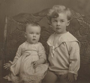
Photograph, Beryl and Geoffrey Mair, 1916
David Miller (Dave) Mair (1879-1938) married Lily Vipond Deakin (1890-1945) in 1910. They had 5 children: Geoffrey David (1913-1970), Beryl (1916-1976), Gwynneth (1917-1997), Isabel Lillian (1921-1997) and Shirley Inez (1928-1968). His parents were Isabella Brown (1856-1944) and William Mair (1850-1924). Personal communication from Laurie Newton, Beryl's daughter: Dave and Beryl initially lived in East Melbourne after they married. Geoffrey, Beryl and Gwynneth were born in East Melbourne. They subsequently moved to Louise Avenue, Mont Albert and Isabel may have been born while they were there. Later they purchased 20 Barton Street, Mont Albert. Shirley was born after they moved to Barton Street. The children attended Mont Albert Central School. Dave was an extremely keen sportsman (particularly bowls and cricket). He started the Kangaroo Cricket Club and worked for the Melbourne Cricket Club.This is part of a large donation related to the Deakin, Mair and Young families with connections to the Surrey Hills / Mont Albert area.A sepia coloured post card photo of (?) a studio portrait with a cream border of 2 children sitting on a couch. The infant is in a light-coloured dress with a lacy border along the hemline and lace embellishments to the sleeves and bodice. The top of the boy's shirt has a 'sailor' collar.REAR: In black ink - "Beryl taken at 8 months / Geoff " " (taken at) 3 years. / 10 Nov. 1916" Handwriting is thought to that of Lily Vipond Mair (nee Deakin). beryl mair, geoffrey david mair, children -
 Kew Historical Society Inc
Photograph - Brick and Stucco Bungalow, J E Barnes, c.1920
The Kew Historical Society's map collection includes a substantial number of real estate subdivision plans, mainly of Kew but also of surrounding suburbs in Melbourne. Most of the subdivision plans date from the 1920s and 1930s when the districts old homes and local farmland were being split up to accommodate residential growth in the postwar period. These early plans were assembled by a local firm, Jas R Mather & McMillan, which had an office in Cotham Road. Many of the plans, and sometimes photos, were annotated by the agents.Subdivision plans are historically important documents used as evidence for the growth of suburbs in Australia. They frequently provide information about when the land was sold as well as evidence relating to surveyors and real estate and financial agents. The numerous subdivision plans in the Kew Historical Society's collection represent working documents, ranging from the initial sketches made in planning a subdivision to printed plans on which auctioneers or agents listed the prices for which individual lots were sold. In a number of cases, the reverse of a subdivision plan in the collection includes a photograph of a house that was also for sale by the agent. These photographs provide significant heritage information relating house design and decoration, fencing and household gardens.The photograph may also be aesthetically significant depending o the importance of the photographic atelier.Real estate photograph for a local agent by the Kew photographer, Josiah Earl Barnes. The photo is of a weatherboard or brick rendered bungalow with a twisted wire fence. Given Barnes' status a a Kew photographer, the house is probably locate din Kew or East Kew. Unfortunately the handwritten information on the mount bordering the photo is damaged and cannot be read. The bungalow has a gabled, tiled roof with terra cotta finials at the front of both gables. The house has a central doorway, framed by a pseudo portico supported by four wooden columns. On each side of the doorway, at the front, there are paired sash windows, which, like the half-timbered gable, are picked out in a darker colour.Handwritten, mostly illegible description by selling agent on mount surround: " .... in Diningroom, Drawing Rooms, ... Photographers details printed on mount: "J. E. Barnes / Photo / Phone 1966 Haw KEW"houses - kew, bungalows - kew, real estate photographs, j.e. barnes -- photographer -
 Victoria Police Museum
Police Stations (Armadale)
Armadale is an inner suburb of Melbourne, Victoria, Australia, 7 km south-east of Melbourne's Central Business District, located within the City of Stonnington local government area. Armadale Police Station opened, in Melbourne Police District, on 11 May 1885. Its original location is unknown, but in 1890 it is listed in the Sands & McDougall directory as at 295 Hight Street. From 1985-1920 it was located at 20/22 Auburn Grove, 1925-1930 at 769 High Street and 1935-1946 at 3 Cheel Street. The station closed on 28 January 1946. The sub-division east of Orrong Rd was incorporated into Malvern Sub-district and west of Orrong Road into Prahran Sub-district. In a special 1930 issue of the Victoria Police Gazette the Armadale Police Station was described as a seven-roomed brick dwelling with a tiled roof on land measuring 127' x 104' x 98'. There was also a bathroom and W.C., a wash-house, office, and a lock-up (one cell). This is probably a description of the Cheel Street police station. It was staffed by one senior constable and three foot constables.12 photographs comprising 8 coloured images and 4 black and white images 1 sketch plan of Old Armadale Police Stationpolice stations; armadale police station -
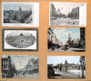 Melbourne Tram Museum
Postcard - Set of 6 mounted cable tram postcards, 1910s
Postcards, all featuring the cable tram era, left to right, top to bottom: 1 - Town Hall Melbourne - damaged paper 2 - General view of Collins Street Melbourne - from Spring St looking west 3 - Central Railway Station, Melbourne - the principal building is complete though the roof along Swanston St over the other platforms is yet to be completed. 4 - Bourke St Melbourne - looking west from Swanston St - has the Wertheim and Roberts Stores in the view along with the post office. 5 - Bourke St Melbourne - looking east from Swanston St with Morells Orient Hotel and the Royal Mail Hotel on the two corners 6 - Melbourne from St Kilda Road.Demonstrates a set of 6 postcards featuring Melbourne cable trams.Set of 6 cable tram postcards mounted on to light weight boardtramways, flinders st station, swanston st, bourke st, collins st, st kilda road -
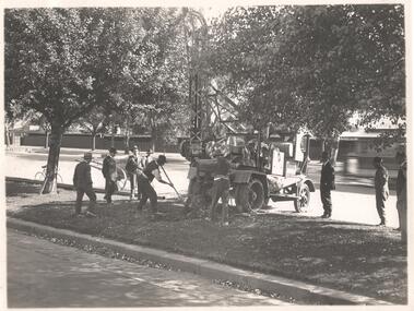 Melbourne Tram Museum
Photograph - Set of 5 Black & White Photograph/s, Sutcliffe Pty Ltd, c1924
Set of five Photographs, Black and White, of St Kilda Road, with works about to commence to convert the cable tram to electric trams. .1 - Overhead pole holes being dug in the one of the central plantations - pole and a Furphy water cart alongside. A cable tram is passing at speed. Note the scale of the houses opposite and the number of side walk superintendents! .2 - View of St Kilda Road with a few motor cars and one cable tram. Looking south on the Sth Melb. side. .3 - ditto, view of cable tram track, poles laid out on the central plantation, note the street lights. About seven cable trams in the view. Look south towards St Kilda Junction. The Junction hotel is in the view. .4 - similar photo, but further north. Cable trailer 74 in the view. .5 - View of St Kilda Road, vehicle road with a number of vehicles in the view. Looking south on the east side of the roadway. Photos Print and photograph by Sutcliffe of Cromwell buildings 366a Bourke St. Melbourne.In ink and pencil on the rear: .1 - "M&MTB H-60, Kew Depot `1920's (E45 in shed)" and the photographers stamp. .2 - "MMTB St Kilda Road about 1924" and in pencil "Tramway poles erected, pole not removed? Sth Melb side, looking south along motor track" .3 - As above - and in pencil - Tramway poles not erected - ????" .4 - As above with notes in pencil. .5 - As above with notes in pencil. About 1924 KSK print number SA932 to SA936.trams, tramways, st kilda rd, cable trams, conversion, trackwork, overhead, construction, tram 74 -
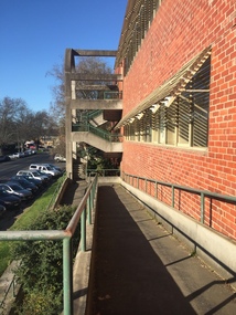 Federation University Historical Collection
Photograph - black and white, Clare Gervasoni, Ballarat School of Mines M.B. John Buildings, 2016, 08/09/2016
The M.B. John Building (Building K), a three storey, face red brick, restrained Late Twentieth Century International styled building with an elongated, cuboid form (defined by the parapeted facades) that is offset by projecting exposed concrete framed, round‐arched entrance and stair wells on the east (Albert Street) elevation (the centrally located entrance breaking the brick façade with glazing). The facades are also characterised by banks of aluminium framed, horizontal ribbon windows, which wrap around the building corners. Metal shades project beyond the windows, while post‐supported bullnosed verandahs and hoods and projecting concrete stairs are other features. On the west elevation, the cuboid façade is punctuated by projecting curved concrete and glazed, elongated bays at first floor level. (David Rowe/Wendy Jacobs)Colour photograph of a red brick building on Albert Street. It was build to house trade workshops and Ceramics at the Ballarat School of Mines. m.b. john, m.b. john building, ballarat school of mines -
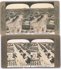 Ballarat Tramway Museum
Photograph - Black & White Photograph/s, Rose Stereograph Co, c1905
Yields information about the appearance of the intersection of Sturt and Lydiard St and Sturt St itself looking west, showing the tram track arrangements.Photographic reproduction - sepia coloured of two stereo pair images with details on the sides. Originals made by the Rose Stereoscopic of Melbourne. Printed on A4 size ink-jet printer. Set of two: 1 - Sturt St and the Lydiard St intersection, electric trams looking east from the Town Hall. Shows Mount Warrenheip. Shows the roof of a tram in the bottom edge and a tram in Bridge St. Has the National Mutual building in the view, advertising the Commercial Union Fire (insurance) and Doepel and Chandler. Another building advertiser is "Carlton Ales" Image No. 8112 2 - Sturt St looking west from the Town Hall tower. Has one tram in the distance. Shows the layout of the Sturt St central median strip.trams, tramways, sturt st, lydiard st, stereo photograph, grenville st, esco, bridge st, town hall -
 Bendigo Historical Society Inc.
Document - MCCOLL, RANKIN AND STANISTREET COLLECTION: CENTRAL NAPOLEON GOLD MINING CO. N.L, 1938-1942
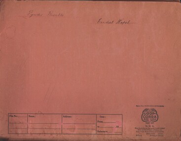
Document: Pink Manilla folder containing invoices for ore purchased by Victor Leggo Mining Co Pty Ltd, Metallurgists, Bendigo School of Mines and Industries Reports on loads taken from mines weighed and contents analysed results in reports, first 6 reports are from Bendigo School of Mines and Industries were headed with their logo, receipts for work by Bendigo School of Mines and Industries, items dated 1st July 1938 to 11 April 1942, markings on front cover read: 'Pyrite Results', 'Central Napoleon', folder has 'East Light Loop Cobra Binder File' logo on cover with ordering instructions and patent number section to write: File Number, Name, Address, Date. Usage instructions inside cover.organization, business, industry - mining, mccoll rankin & stanistreet, mining, gold mining, central napoleon -
 Orbost & District Historical Society
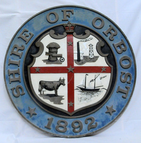
plaque
The Coat of Arms of the Shire of Orbost has been designed in the form of a cross in which five stars are set on a shield. This was typical of those used by many shires and cities throughout Victoria and the Commonwealth. A small crown above the cross indicates the loyalty of the President, Councillors and Ratepayers to the reigning King or Queen. The inner circle of the shield contains four figures, a sheaf of wheat, a factory, a cow, and a ship, which represents the activities of agriculture, fishing, industry and dairying undertaken in the district. Originally part of the Bairnsdale district, Orbost split away as part of the Shire of Tambo in 1882, and became a Shire in its own right as the Shire of Croajingolong on the 30th may 1892. The name changed to the Shire of Orbost on 17 February 1893. Orbost was divided into four ridings on 31st May 1895, they were the North, South, East and Central riding, which was represented by three elected councillors. The Shire coat of arms was on the wall on the right of the front entrance to the building and was removed from the current building when Orbost Shire Council was amalgamated into East Gippsland Shire in 1994.The current building was opened on Friday 28th February 1969 by the Premier of Victoria, The Hon. Sir Henry E. Bolte, K.C.M.G., M.P. Local governments play an important role in the lives of citizens in Australia. Local government authorities exist to provide services and amenities to local communities, and are also responsible for regulating and providing services for land and property in their district. This item is representative of a time when Orbost had its own Shire Council. A large round metal plaque with the words SHIRE OF ORBOST1892 in gold letters around a crown and shield divided into four sections to represent four industries : Shipping ; farming - maize ; dairy and mining.SHIRE OF ORBOST 1892government orbost-shire-council coat-of-arms plaque -
 City of Moorabbin Historical Society (Operating the Box Cottage Museum)
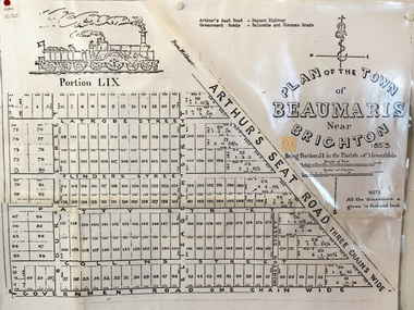
Document, photocopy of Plan of Beaumaris 1853, c1960
Beaumaris includes two early estates in the parish of Moorabbin developed by Josiah Holloway from 1852. Named Beaumaris Town and Beaumaris Estate (after the pastoral run in the area and ultimately after Beaumaris in Wales), the lots comprising them were marketed by Mr Holloway's suggesting that the railway was imminent and a canal would be built. The township developed slowly, a Post Office opened on 1 March 1868, but was replaced next month by Gipsy Village office (now Sandringham) In 1862 Beaumaris was one of the early settler communities within the boundaries of the Moorabbin District Roads Board , the region’s first local government authority. Beaumaris is a suburb in Melbourne, Victoria, Australia, 19 km south-east from Melbourne's central business district. .Since the Amalgamation of Councils 1994 the local government area is the City of Bayside which includes Brighton. A Photocopy of the Plan of Beaumaris 1853 A3moorabbin, county of bourke, brighton, beaumaris, pioneers, early settlers. market gardeners, cheltenham, king. john, holloway josiah, whorral charles, arthur’s seat road, nepean highway, morabbin district roads board, sandringham, mordialloc, mentone -
 Federation University Historical Collection
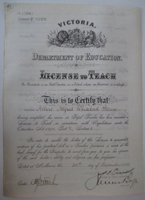
Certificate, Education Department Victoria, License to Teach made out to Albert Steane, 25/09/1899
Born at Sandhurst, Victoria Albert Steane attended the Gravel Hill State School until the fourth class, then transferred to the Central School 1976 where he gained the Merit Certificate. The monitor system of teacher training had been introduced and he passed fourth, third, second and first class pupil teacher. At about 16 years of age he was appointed a teacher monitor at 12 pounds per annum. Albert Steane was awarded the Teachers' Certificate of Competency in 1897. He was the first headmaster of the Ballarat Technical School (1913), and opened the Sloyd (woodwork) Centre in 1902 at the Ballarat East Art School (later known as the Ballarat East Free Library). of Mines and Industries Ballarat (SMB). Steane is known for the teaching of Sloyd or woodwork, which was an important point in his career, and for his love of gymnastics. He was made a life member of the Ballarat Y.M.C.A. in 1968 aged 91 years. The teaching of woodwork in Victoria began in 1901 and Steane was chosen, among 18 others for the inaugural training course at Queensberry State School in Melbourne. Steane died, aged 93 years, on 13 July 1970, at Sydney, leaving his widow Grace Elliott Steane and children Eric and Violet. (See http://guerin.ballarat.edu.au/curator/honour-roll/honourroll_steane.shtml)Victorian Education Department License to Teach Certificate printed and handwriiten on to parchment like paper, made out to Albert Alfred Whitelock Steane. License No. .education, teaching, albert steane, aaw steane -
 4th/19th Prince of Wales's Light Horse Regiment Unit History Room
Medal, Defence Medal, abt 1945
The Defence Medal was instituted to provide recognition for specified periods of service in non-operational areas subjected to air attack or closely threatened. Eligibility The Defence Medal is awarded for six months service in a prescribed non-operational area subject to enemy air attack or closely threatened, in Australia and overseas, or for 12 months service in non-prescribed non-operational areas. Within Australia the area is the Northern Territory , north of 14 degrees 30 minutes south, and the Torres Strait Islands between 3 September 1939 and 2 September 1945. Overseas service includes the Middle East, east of the Suez Canal (less the period of the Syrian Campaign) or Malaya prior to the Japanese invasion on 8 December 1941. The Medal The Defence Medal is cupro-nickel, with the uncrowned effigy of King George VI on the obverse. The reverse has a conventional oak tree centrally, with a crown above, with two lions counter rampart as supporters between the dates 1939 and 1945. The base of the medal reverse has the words ‘THE DEFENCE MEDAL'. The Ribbon The Defence Medal ribbon is orange with green outer stripes, each green stripe having a black pin-stripe running down the centre. The green represents the Islands of the United Kingdom, the orange represents enemy attacks, and the black represents the black outs.Full size and miniature medals with ribbonsnildefence medal -
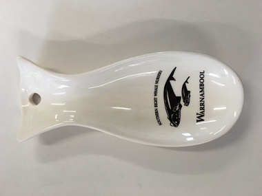 Warrnambool and District Historical Society Inc.
China, Spoon Rest, Early 21st century
This spoon rest is a souvenir item for tourists to purchase. It is a souvenir of the presence of Southern Right whales at Logans Beach, a few kilometres from Warrnambool’s Central Business District. Each year Southern Right whales have been migrating from sub-Antarctic waters to the east coast of Australia during the winter months. Some whales have been coming each year from approximately May to October (since the 1980s) to have their calves at Logans Beach near Warrnambool. This area is now known as Warrnambool’s Southern Right Nursery. The whales calve about every three years and stay in the local waters along with other whales for about three months and over the past thirty years or so over 100 calves have been born at Logans Beach. The whales are now a winter tourist attraction (if an unpredictable one) as they can be viewed from a raised purpose-built platform area and they are often very close to the shore.This spoon rest is of interest as it is a souvenir of the Southern Right Whale Nursery at Logans Beach, Warrnambool and it has a practical use in the kitchen. It indicates the popularity of whale-viewing at Logans Beach and the importance of the presence of the whales, both scientifically and economically as the annual whale migration to our waters is now a vital aspect of tourism in Warrnambool. This is a Warrnambool souvenir cream-coloured china spoon rest in the shape of a whale or fish. It has a hole at the top for hanging the item on a hook and the printed material is in black and includes a sketch of a mother whale and calf. It has the distributor’s name on the back in yellow writing with an outline of a map of Victoria with a dot to show the location of Warrnambool.‘Southern Right Whale Nursery, Warrnambool’ ‘Lady Bay Creations, Warrnambool, Australia’ southern right whales, warrnambool’s southern right whale nursery, history of warrnambool -
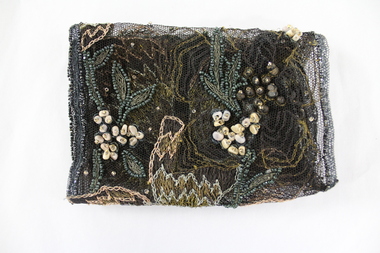 Wodonga & District Historical Society Inc
Textile - Hamilton-Smith Collection Beaded Textile c. late 1800s - early 1900s
The Hamilton-Smith collection was donated by the children of Grace Mary Hamilton-Smith nee Ellwood (1911-2004) and John Hamilton-Smith (1909-1984) who settled in Wodonga in the 1940s. The Ellwood family had lived in north-east Victoria since the late 1800s. Grace’s mother, Rosina Ellwood nee Smale, was the first teacher at Baranduda in 1888, and a foundation member of the C.W.A. Rosina and her husband Mark retired to Wodonga in 1934. Grace and John married at St. David’s Church, Albury in 1941. John was a grazier, and actively involved in Agricultural Societies. The collection contains significant items which reflect the local history of Wodonga, including handmade needlework, books, photographs, a wedding dress, maps, and material relating to the world wars. In the nineteenth and early twentieth century prior to the mass production of clothing and textiles, needlework, alongside motherhood, was the defining work of women. Hand sewing and embroidery was central in the everyday lives and domestic roles of women.This item is unique, handmade and has a known owner. It forms part of a significant and representative historical collection which reflects the local history of Wodonga. It contributes to our understanding of social and family life in early twentieth century Wodonga, as well as providing interpretative capacity for themes including local history, social history and women’s history.Bronze and gold embroidery and bead work on black mesh.needlework, beading, sewing, sew, hamilton-smith collection, hamilton-smith, ellwood, handmade, domestic, women, women's history -
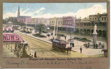 Ballarat Tramway Museum
Postcard, "Shoppee and Alexandra Squares Ballarat Vic.", c1904
Printed colour postcard from top of the Town Hall, looking northwest with Snows building in the foreground looking west. Has a horse tram travelling up to Lydiard St. on the south side of Sturt St. Has the buildings on north side of Sturt St. in the view, including the central median reserve before the trees had grown. Titled "Shoppee and Alexandra Squares, Ballarat Vic." along the bottom edge. On the bottom of the postcard is a one line hand written message, ink fading, very hard to read. On rear of postcard is the address to a Mr Frank Tucker, Glencairn, Park Avenue, Harrogate, England. Has two Victorian stamps, half penny (green) and one penny (red) stamps. Has been postmarked, "Ballarat East 16.11.04". See images .1 and .2. Two copies held - on the second copy, the address details have been crossed out and the stamp removed. Yields information about central Ballarat in the horse tram days.Postcard - printed colour, divided back, used.trams, tramways, horse trams, sturt st, postcards, snows, tram 3 -
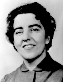 Surrey Hills Historical Society Collection
Photograph, Matron Joan Bray of Barton Street, Surrey Hills
Joan Mary Bray was born 6/9/1915 in Brisbane, the daughter of Herbert Edward Bray and his wife Grace (nee Shepherd) who married in Wisbech, Cambridge in 1892. The family lived at 5 Barton Street from the late 1920s. She completed her primary schooling at Auburn Primary by travelling there by the little black bus along Canterbury Road. She then went on to Mont Albert Central School and Melbourne Girls High. Locally she belonged to the 1st Surrey Hills Girl Guide Company at Holy Trinity Church. She trained as a nurse at Epworth Hospital and in 1941 served with the army at Gaza Hospital in the Middle East, then in New Guinea. From 1944 until the end of the war she was in Bougainville. Her mother died in Surrey Hills 29/9/1945 and her father moved to Hawthorn; he died in 1955. She had 3 older sisters: Eveline Grace (1893-1978) m Eric Benson; Violet Constance (1894-1983 - ? Sister Constance in mother’s death notice); Dorothy Maud (1896 - ? Sister Ursula in mother’s death notice). After the war she was a RSSL nurse, Matron of St Gabriel’s Baby Home in Balwyn, then Director of Nursing at the Royal Eye and Ear Hospital, East Melbourne. She resigned to be married. [No success in locating her marriage, presumed to be to UNKNOWN Wicks.]Black and white head and shoulders portrait of Joan Bray. She is wearing a plain shirt or jacket.barton street, mont albert central school, auburn primary school, melbourne girls high school, girl guides, 1st surrey hills girl guide company, nurses, nursing, hospitals, health services, australian army nursing service, world wars, 1939-1945, epworth hospital, st gabriel's baby home, eye and ear hospital, (miss) joan mary bray, matron joan bray, (mrs) joan wicks -
 Bayside Gallery - Bayside City Council Art & Heritage Collection
Map, H.B. Foot, Plan of the Brighton Estate containing 5120 acres, first special survey at Port Phillip, c. 1842
This plan records the Brighton Estate, also known as Dendy's Special Survey. In 1840 Henry Dendy, a farmer in Surrey, England acquired a "Special Survey" from the Commissioners for Land and Emigration which gave him the right to choose land in Port Phillip for the low price of £1 per acre for 5120 acres. Dendy appointed Jonathan Binns Were, as his agent, who later became a partner. Together, Dendy and Were decided on an area 5 miles south from Melbourne, bounded by North Road, East Boundary Road, South Road and to the west by Port Phillip Bay. Their Brighton Estate was first surveyed by T. S. Townsend in May 1841 and was re-surveyed by Robert Hoddle. Dendy and Were were making plans to sell the land and advertised a 30-guinea prize for the best subdivision which was to be divided into a village, marine residences, suburban and cultivation allotments, with the remainder being divided into country sections. The competition was won by H.B. Foot, who planned the village around a reserve and crescents and a 'green belt' forming the town boundary. brighton estate, dendy's special survey, special survey, henry dendy, jonathan binns were, w.b. were, survey, plan, map, brighton, george ward cole, baker's lithographer, hibernian, subdivision, town planning, cartographic material, h.b. foot -
 Bendigo Historical Society Inc.
Document - MCCOLL, RANKIN AND STANISTREET COLLECTION: NOTES RE GOVERNMENT GAZETTES AND LIST OF PLANT
Two page, handwritten document on lined paper - front page reference to Victorian Government Gazettes and Chinese regulations, where listed in the gazettes and dates. Includes Chinese regulations for management of Chinese on Gold fields (1856) , Chinamans Flat Steam Engine company (1857), two Chinese murdered at Clinkers Hill, Castlemaine (1862) Charles Chromley Dowling appointed Chinese Protector (1857), John Chatfield Tyler Immigration agent, to carry out the Chinese Emigrations Act (1861) Back page dated 1947 lists "stocktake list of plant" On list - Deborah United 1946; North Hustlers; New Monument GMC, North Virginia, South Wattle Gully, Central Napoleon, Red, White and Blue Extended, Deborah Extended, New Don, East Clarence, Napoleon Reef, New Monument Battery, Deborah Extended. Possibly written by Albert Richardson.bendigo, mining, mccoll rankin & stanistreet -
![Scene near Corranderrk Station / [by] Nicholas Caire, circa 1876](/media/collectors/550653872162f11fb04854aa/items/57774ae0d0cdd10a5c12f2d7/item-media/57774b61d0cdd10a5c132dac/item-fit-380x285.jpg) Kew Historical Society Inc
Kew Historical Society IncPhotograph, Anglo-Australasian Photographic Company, Scene near Corranderrk Station, c. 1876
Nicholas Caire was born on Guernsey in the Channel Islands in 1837. He arrived in Adelaide with his parents in about 1860. In 1867, following photographic journeys in Gippsland, he opened a studio in Adelaide. From 1870 to 1876 he lived and worked in Talbot in Central Victoria. In 1876 he purchased T. F. Chuck's studios in the Royal Arcade Melbourne. In 1885, following the introduction of dry plate photography, he began a series of landscape series, which were commercially successful. As a photographer, he travelled extensively through Victoria, photographing places few of his contemporaries had previously seen. He died in 1918. Reference: Jack Cato, 'Caire, Nicholas John (1837–1918)', Australian Dictionary of Biography. The 1860s marked the beginning of the era of reserves and missions. Six Aboriginal reserves were established during the 1860s. These were under the control of the Board for the Protection of Aborigines. Four were Christian missions receiving government aid. These were Lake Tyers (Anglican) and Ramahyuck (Presbyterian/Moravian) in eastern Victoria for the Gunai/Kurnai clans; Ebenezer (Moravian) in north-west Victoria for the clans of the Wimmera and Lower Murray; and Lake Condah (Anglican) in south-west Victoria. The other two were secular government controlled reserves: Framlingham which, like Lake Condah, was established for the Mara-speaking Gunditjmara and Kirrae-wurrung people of south-west Victoria; and Coranderrk, located about 60 kilometres north-east of Melbourne, for the Kulin clans of central Victoria. In 1863, after a period of devastation to the Kulin people, Coranderrk was established at the junction of the Yarra River and Badger Creek. Reference: http://coranderrk.com/, accessed 24 December 2016An original, rare photograph from the series 'Views of Victoria: General Series' by the photographer, Nicholas Caire (1837-1918). The series of 60 photographs that comprise the series was issued c. 1876 and reinforced a neo-Romantic view of the Australian landscape to which a growing nationalist movement would respond. Nicholas Caire was active as a photographer in Australia from 1858 until his death in 1918. His vision of the Australian bush and pioneer life had a counterpart in the works of Henry Lawson and other nationalist poets, authors and painters.Albumen silver photograph mounted on boardprinted in ink on support l.c.: SCENE NEAR "CORRANDERRK" STATION. / COPYRIGHT REGISTERED. printed in ink on support reverse c.: VIEWS OF VICTORIA. / (GENERAL SERIES.) / No. 9. / SCENE NEAR "CORRANDERRK" STATION. / This scene was taken from the hill near Rourke's Bridge, on the Healesville Road, and displays in the foreground / the River Yarra. The roadway which is seen in the mid-distance has lately been constructed by the Government, / as the old tracks which formerly existed, were liable to be swamped by the periodical overflowing of the River. Mount / Ridell can be seen in the extreme distance immediately behind the roadway. / Corranderrk is the local habitation / for the natives of this district, and is situated on the right hand side of the picture, about a mile and a half / from the roadway. printed in ink on support reverse l.c.l.: J.W. FORBES, Agent, printed in ink on support reverse l.c.: ANGLO-AUSTRALASIAN PHOTOGRAPHIC COMPANY, MELBOURNE. printed in ink on support reverse l.c.r.: 10 Temple Court, Collins Street West.nicholas caire (1837-1918), coranderrk aboriginal station, aborigine, yarra river, badger creek, first peoples, aboriginal and torres straight islander -
 Federation University Historical Collection
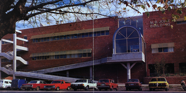
Image - Colour, Ballarat School of Mines M.B. John Building, Albert Street, Ballarat, 1987
The M.B. John Trade–Art building (Albert Street front) of SMB was officially opened by the Hon. John Cain, Premier of Victoria, in the presence of Morgan B. John. Programs include 3 Dimensional Art, Painting & Decorating, and Engineering Trades. (SMB Institutional Plan 1989) The M.B. John Building (Building K), a three storey, face red brick, restrained Late Twentieth Century International styled building with an elongated, cuboid form (defined by the parapeted facades) that is offset by projecting exposed concrete framed, round‐arched entrance and stair wells on the east (Albert Street) elevation (the centrally located entrance breaking the brick façade with glazing). The facades are also characterised by banks of aluminium framed, horizontal ribbon windows, which wrap around the building corners. Metal shades project beyond the windows, while post‐supported bullnosed verandahs and hoods and projecting concrete stairs are other features. On the west elevation, the cuboid façade is punctuated by projecting curved concrete and glazed, elongated bays at first floor level. (David Rowe/Wendy Jacobs)Image of a multi-storey brick building on the Ballarat School of Mines campus. The building is known as the M.B. John Building.ballarat school of mines, m.b. john building, morgan b. john, albert street, m.b. john -
 Bendigo Historical Society Inc.
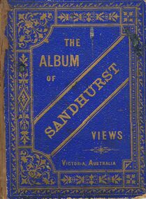
Book - MERLE HALL COLLECTION: THE ALBUM OF SANDHURST VIEWS
A bound book of 16 drawings B&W (lithographs?) in ''photographic'' detail of well-known Sandhurst Views - Town Hall, Mechanics Institute, Masonic Hall, Bendigo Hospital, Bendigo Benevolent Asylum, Post and Telegraph Offices, Mining Exchange, View from Post Office Tower looking East, View from Post Office Tower looking West, Central State School, Alexandra Fountain, Upper Lake,Rosalind Park, Fernery Rosalind Park, St Pauls Church, Bishop's Palace, General View - New Chum Line, Koch's ''Pioneer'' Crushing Works, Quartz Crushing batteries, Town Hall - Eaglehawk, Railway Station. Appended with two pages summarizing Sandhurst history; current councillors and officers, brief review of five places - Bendigo Hospital, Benevolent Asylum, Mechanics Institute and Free Library, School of Mines and Industries, Masonic Hall. Date is given as ''The present (1888) occupants are ....'' -
 Whitehorse Historical Society Inc.
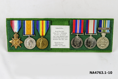
Medal - Military Medals, World War medals WW1 and WW2, 1919 1946
Issued to Defence personnel for service during world war I and II1. Green felt covered board with 6 medals to the Father Boleslas Slaweski (Staff Sgt ,Warrant Officer)and Son Bernard Bruce Slaweski and son 2 1914 -1915 star Bronze medal with 4 stars with crown on top star, ribbon has red white and blue colours merged at edges. Medal has crossed swords and laurel wreath Engraved on rear 7637 S/Sgt B Slaweski 1/6 Hosp. A. I. F. 3 British War medal circular medal of Silver Words on obverse GEORGIUS V BRITT OMN REX ET IND EMP AROUND THE HEAD OF KING GEORGE V Reverse has a figure of St. George mounted on a horse with a short sword in one hand, the other raised in victory. The horse tramples on the figures of death the Prussian eagle and skull and crossbones in the background are ocean waves The years 1914 1918 are embossed on the sides Around the edge is 7637 W O 1 B Slaweski A.M.C. A.I.F. Ribbon is dark blue, black, white,orange, white, black and dark blue 3. Victory medal Bronze medal with winged victory figure on obverse with The great war fro civilisation 1914 1918 non the reverse Ribbon is watered from a central red stripe through yellow green blue and purple 4 War medal 1939- 1945 Medal is round cupro nickel obverse shows head of King George 6th with circular inscription G.B>R> REXETINDIAE IMP GEORGIVS VI Reverse has a lion standing on a dragon the top shows the dates 1939- 1945 Ribbon is narrow red central strip with radiating stripes of white (narrow) and blue and red|5 Australian Service medal 1939 - 1945 Nickel silver medal with crowned effigy of King George VI on the obverse Reverse has Australian Coat of Arms placed centrally surrounded by the words The Australian Service Medal 1939- 1945 Ribbon has wide Khaki central stripe flanked by two narrow red stripes and one of dark blue (navy) and one of light blue. (Air Force)|6. Australian Service medal 1945 -1975 Reverse has Federation star with name B B Slaweski R 38254 Ribbon Central yellow stripe with green flanked by navy blue Khaki and light blue stripes Medal has clasps PNG and FESR (Far East Strategic Reserve)|7 Small Clasps (For miniature medals )PNG and FESR Photo on back of Board Father and son Slaweski 8 Letter 2/2/1999 addressed to Mitcham RSL with details of Boreslas and Kevin Slaweski. 9 Letter dated 11/2/1999 to Mitcham RSL regarding PNG clasp.B Slaweski B B Slaweskimilitary history, army -
 Ringwood and District Historical Society
Flyer, Stillwell & Stephens Pty. Ltd, Brochure - Multiple Properties for Public Auction at Box Hill, Ringwood, Wonga Park and Clarinda - 28th November, 1934
Seven-page brochure advertising Mortgagees' Realising Sale by Public Auction on Wednesday, 28th November, 1934 for properties at Box Hill, Ringwood, Wonga Park, and Clarinda (via Oakleigh), including photographs, property descriptions, and terms of sale.Auction Commencing at 2.15 p.m. in the Orient Line Auction Rooms, 352 Collins Street, Melbourne. Solicitors: Messrs. Madden, Butler, Elder & Graham, 406 Collins Street, Melbourne. (Agents) H.P. Knight & Co. Property Salesmen and Subidivisional Experts, 315 Collins Street, Melbourne, 'Phones: Central 10615, 10616. Attractive Residential, Orchard, and Market Garden Properties, and Public Hall and School Rooms. 1. Wonga Park via Ringwood - "Holme Bush" off Warrandyte Road, Part of Lots 14 and 15, Ringwood Orchard Estate, approximatgely three miles (north) of Ringwood Railway Station - 64 Acres. 2. 17 Bishop Street, Box Hill - timber residence. 3. Greenwood Avenue, Ringwood - On East Side, 150 feet 3 inches South of Bedford Road - timber attic residence. 4. Ringwood - Wantirna Road, South-east corner of Canterbury Road - Orchard Property of approx. 11-1/2 Acres. 5. Box Hill - Whitehorse Road, South-east corner of Linsley Street - Timber building utilised as a Public Hall and Private School. 6. Clarinda vic Oakleigh, Talbot Crescent, off Centre Road - Home on 10 acres of land. -
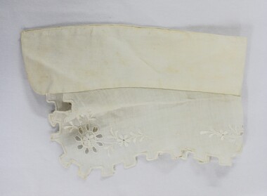 Wodonga & District Historical Society Inc
Clothing - Hamilton-Smith Broderie Anglaise Collar c. late 1800s - early 1900s
The Hamilton-Smith collection was donated by the children of Grace Mary Hamilton-Smith nee Ellwood (1911-2004) and John Hamilton-Smith (1909-1984) who settled in Wodonga in the 1940s. The Ellwood family had lived in north-east Victoria since the late 1800s. Grace’s mother, Rosina Ellwood nee Smale, was the first teacher at Baranduda in 1888, and a foundation member of the C.W.A. Rosina and her husband Mark retired to Wodonga in 1934. Grace and John married at St. David’s Church, Albury in 1941. John was a grazier, and actively involved in Agricultural Societies. The collection contains significant items which reflect the local history of Wodonga, including handmade needlework, books, photographs, a wedding dress, maps, and material relating to the world wars. This collar was made using the broderie anglaise needlework technique that incorporates embroidery, cutwork and needle lace. This technique originated in sixteenth century Europe and became popular in England in the nineteenth century. In the nineteenth and early twentieth century prior to the mass production of clothing and textiles, needlework, alongside motherhood, was the defining work of women. Hand sewing and embroidery was central in the everyday lives and domestic roles of women.This item is unique, handmade and has a known owner. It forms part of a significant and representative historical collection which reflects the local history of Wodonga. It contributes to our understanding of social and family life in early twentieth century Wodonga, as well as providing interpretative capacity for themes including local history, social history and women’s history.A white cotton collar from the Edwardian period with broderie anglaise embroidery. hamilton-smith, hamilton-smith collection, needlework, clothing, sewing, embroidery, women, domestic, edwardian -
 Wodonga & District Historical Society Inc
Memorabilia - CountryLink Collection, c2000
For residents of Northeast Victoria, railway services have provided a critical link between the area and state capital cities. CountryLink was established in January 1989 under the Transport Administration Act 1988. It was a passenger rail and road service brand that operated in regional areas of New South Wales, and to and from Canberra, Brisbane and Melbourne. CountryLink operated rail services a fleet of XPT and locomotive-hauled passenger trains. The Southern region of the Country Link network covered New South Wales districts of Illawarra, South Coast, Snowy Mountains, South West Slopes, Southern Tablelands, Riverina and Sunraysia regions plus the Australian Capital Territory and parts of Victoria. The Government of Victoria contributed to the provision of these services. Services ran along the Main South line from Sydney Central station to Albury before continuing on the North East line to Southern Cross station in Melbourne. The Sydney/Melbourne Express ceased in November 1993 and was replaced by an XPT in November 1993 In December 1994, a daylight service to Melbourne resumed by extending the Riverina XPT from Albury. In July 2013, CountryLink was merged with the intercity services of CityRail to form NSW TrainLink.These items are connected to a major transportation system in eastern Australia.A collection of uniform items and memorabilia from the CountryLink rail service. They include a tie and tiepin, staff badge and lanyard, cups and a bag with CountryLink logo.Tag on tie: Stylecore Corporate Wear Australia/ Polyester/ Made in England On all items: CountryLinkcountrylink, australian railways, countrylink uniforms -
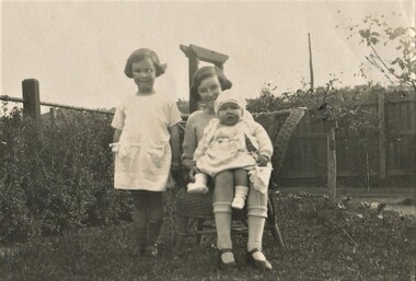 Surrey Hills Historical Society Collection
Photograph, Isabel and Beryl Mair with cousin Margaret Williamson, 1916
David Miller (Dave) Mair (1879-1938) married Lily Vipond Deakin (1890-1945) in 1910. They had 5 children: Geoffrey David (1913-1970), Beryl (1916-1976), Gwynneth (1917-1997), Isabel Lillian (1921-1997) and Shirley Inez (1928-1968). Personal communication from Laurie Newton, Beryl's daughter: Dave and Beryl initially lived in East Melbourne after they married. Geoffrey, Beryl and Gwynneth were born in East Melbourne. They subsequently moved to Louise Avenue, Mont Albert and Isabel may have been born while they were there. Later they purchased 20 Barton Street, Mont Albert. Shirley was born after they moved to Barton Street. The children attended Mont Albert Central School. Lily's sister Alice married Hector Williamson (1892-1981) in 1921. Hector was a civil servant and worked at the Melbourne Museum, where accommodation was provided. They had one daughter Margaret. Another sister Minnie (Min) married Hector's brother Charles (Charlie) Prosser Williamson (1893-1961). Charlie was an engineer and ran a hardware business in Whitehorse Road (near the tram terminus). They lived at 12 Barloa Road and had one son, Donald Williamson, born 1924. Donald (Service number VX146389) entered RMC on 28 February 1942 and graduated on 14 December 1943. He enlisted the following day as a Lieutenant with the 2/32 Infantry Battalion. He was mentioned in Despatches "for exceptional service in the field S.W.P. area". Promulgated in the Commonwealth of Australia Gazette 6 March 1947; was killed in action in Brunei on 3 July 1945. Williamson was buried in grave B.C.10 in Labuan War Cemetery, Borneo, Malaysia.This is part of a large donation related to the Deakin, Mair and Young families with connections to the Surrey Hills / Mont Albert area.A sepia coloured photo with a cream border of 2 girls in either a front or back garden. One is sitting on a cane chair and holding a young baby; the other is standing close by. The fence behind appears to be of constructed of posts with a metal horizontal support and wire mesh. REAR: In blue biro "Isabel Beryl / Margaret Williamson / (cousin) / Auntie Alice & Uncle Hec / her mother & father" The handwriting is believed to be that of Beryl Mair. margaret williamson, beryl mair, isabel mair, children -
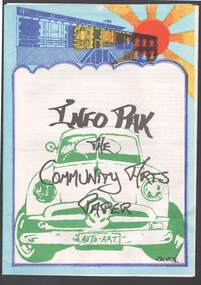 Bendigo Historical Society Inc.
Document - MERLE HALL COLLECTION: DOCUMENTS RELATING TO ORGANIZATIONS (NOT BENDIGO BASED)
Documents relating to organizations (not Bendigo based): a. Flyer (bi fold) ''A Community Radio Station for Central Victoria?'' re obtaining an FM radio broadcasting licence- Central Victorian Community Broadcasting Association; b. paper presented at Bendigo seminar for ''Regionalism and the Arts'' 13/7/1985 by Ric McCracken, Footscray Community Arts Centre; c. 12 page booklet ''Info Pak - the Community Arts Paper'' published by the Footscray Community Arts Centre, 1978; d. 4 -paged Newsletter of the Victoria Welsh Male Voice Choir, issue 1, May2002 ''Tongues of Fire''; e. 8-paged booklet describing the Robert Blackwood Hall, Monash University, Clayton (pub. Ca. 1971?); f. 26- paged ''Work Guide - How to establish an Artist In Community project'' , published by the Community Arts Resource Centre, East Melbourne , 1989; g. info sheet on residential schools, Jan 1979 - ''Mime and Dance Education'', Dept of Continuing Education, University of New England; h. personal and artistic information re potter, Judy Lorraine , Wedderburn; i. Copied extracts from ''Australian Quilts - The People and Their Art'' descriptions of the work of nine quilters from The Quilters Guild, pub. By Simon Schuster (no date); j. letter from The Lieder Society of Victoria Inc to Arts Bendigo October 2001 re opportunities for concerts in area; k. information about various performances of the Australian Performing Group, APG, (Pram Factory) -no stated date -
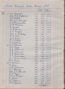 Bendigo Historical Society Inc.
Book - MCCOLL, RANKIN AND STANISTREET COLLECTION: SHARE REGISTER - VARIOUS MINES LISTED BELOW, 1952
Book; Hard cover with paper pages listing shares held by shareholders and funds distributed. 1. South Deborah G.M. N.L. - 1st & final distribution. 2. Monument Hill Cons. N.L. 1st & final distribution. 3. Napoleon Reef G.M. N.L. 1st & final distribution. 4. South Wattle Gully Co. N.L. 1st 7 final distribution. 5. East Clarence G.M. Co. N.L. 1st 7 final distribution. 6. Golden Carshalton G.M. N.L. 1st 7 final distribution. 7. South Nell Gwynne G. M. N.L. 1st 7 final distribution. 8. North Virginia G.M. N.L. 1st 7 final distribution. 9. Central Napoleon G.M. N.L. 1st & final distribution. 10. Red White & Blue Extended G.M. N.L. 1st & final distribution. 11. South Costerfield Antimony G.M. Co. N.L. 1st & final distribution. Graphic Analysis Book 13 Sets on front cover.MCCOLL RANKIN & STANISTREETorganisation, industry, shares, mccoll rankin & stanistreet