Showing 170 items
matching contours
-
 Bendigo Historical Society Inc.
Photograph - The Young and Wirth Families at Preston Vale, near the Springs Sedgwick, 1880s-1900s
The Phil Wilkin Collection contains a series of 11 Items. The related items can be found by clicking on the reference link below. The following history of the Young family and their descendants who lived at the Springs is provided by Phil Wilkin. His Great Grandparents were Frances Young and August Wirth. Phil has also provided notes on the Wilkin Family and some history of the gold mining in Sedgwick. Frances Young's parents Joseph and Margaret Young owned the property called "The Old Place, Preston Vale or Wellington Flat" at Sedgwick near the Springs. Joseph Young owned and Managed the Standard Brewery which was located at Campbells Creek during the late 1800’s early 1900’s. Joseph and Margaret are buried in the Harcourt cemetery. In 1880 August Wirth lived at Mosquito Creek (Lake Eppalock, Victoria) when he married Frances Young. In 1902 they moved to part of Joseph Young's property. They milked cows and sold cattle for a living. One of their children Charles Wirth (Phil Wilkin's Grandfather) bought the land in 1935 after his parents had died. Charles Wirth was a councillor and also was president of the Shire of Strathfieldsaye. The "Old Place" was part of the property owned by members of the family. The old house at the Springs was burnt out by bushfire in January 1944 and much of the stonework was later vandalized by campers. The original Coliban Water Works were designed in 1863 by the Irish engineer Joseph Brady. The system included 70 kilometres of open water channels, aqueducts, syphons and tunnels to carry water (by gravity) from the Coliban River at Malmsbury, north to Castlemaine and Bendigo. Sedgwick is a locality in Central Victoria, Australia. It is located in the City of Greater Bendigo. Facilities include a public hall that opened in 1958 and CFA Rural fire station. It was named Upper Emu Creek until 1901 when it was renamed as Sedgwick after British geologist Adam Sedgwick.Thirty Four Photos of Joseph Young's property near "The Springs" on the main Coliban water channel from Malmsbury to the Sandhurst Reservoir in Bendigo. This item contains family history of Joeph's descendant Charles Wirth, who was a councillor for the Shire of Strathfieldsaye. The water race descends through a concrete chute, and continues sharply around the contour of the hills. Once it descended into a syphon across the gully. The are 182 photos in this series and can be found at 8683.1 to 8683.11. The series also includes photos of the surrounding farming land and the remains of an old house. There are also some notes on the pioneers of the district.history, bendigo, coliban water, joseph brady, irrigation, the springs, sedgwick, charles wirth, preston vale, joseph and margaret young, standard brewery campbells creek harcourt, phil wilkin collection -
 Kew Historical Society Inc
Map, MMBW, MMBW Plan No.40 Collingwood & Kew, 1900-1910
The Melbourne and Metropolitan Board of Works (MMBW) was established by an act of the Victorian Parliament in 1890 to prepare for and to implement a sewerage and water reticulation system across what was then inner Melbourne, its surrounding and middle distance suburbs, including Kew. The MMBW was disbanded in 1991.The map collection of the Kew Historical Society has at its core the historic maps assembled and originally stored in the City Engineer's Department of the City of Kew. These include maps in a number of scales. The vast majority of maps were produced by the MMBW in the first two decades of the twentieth century, and are solid working maps, backed by linen for durability. These maps are historically significant to Kew, the City of Boroondara and to the history of the development of state utilities in Victoria. A number of the Kew maps have additional details added by former municipal officers, including the levels reached by various floods. As these were working documents, information was added to them long after the period of their initial production and distribution.Early map of part of the Borough of Kew, created in the first decade of the twentieth century, at a scale 160 ft to 1 inch. The map covers what was then the south western section of Kew, bordered on its north by Studley Park Road, in the west by Walmer Street and the River Yarra, by High Street South and Princess Street in the East and Barkers Road in the south. The map shows the extent of urban development by that time, prominent institutions and the outlines of built structures in the municipality. Contour lines and historic flood levels were added in ink to the map at a later stage.MELBOURNE AND METROPOLITAN BOARD OF WORKS / PLAN NO. 40 / COLLINGWOOD & KEWmelbourne & metropolitan board of works, mmbw maps, mmbw plans, borough of kew, cartography -
 Bendigo Historical Society Inc.
Map - LONG GULLY HISTORY GROUP COLLECTION: MAP OF LONG GULLY/CALIFORNIA GULLY AREA
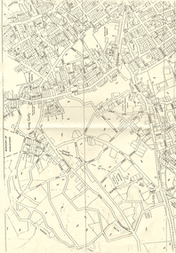
BHS CollectionTwo copies of a map, printed on yellow paper, of the Long Gully/California Gully Area. It shows Eaglehawk Road from Craig Street then Mr Korong Road,to the Murray Valley Highway to just past Avenue Street. Sandhurst Road and Holmes Road are to the right. To the left is California Gully Road. Water Supply Purposes Reserve, Mental Hygiene Authority, Comet Hill State School Reserve, Agricultural Showgrounds and Recreation Reserve, Rubbish Reserve and two un-named State Schools are shown. Some contours are also shown.bendigo, history, long gully history group, the long gully history group - map of long gully/california gully area -
 Kiewa Valley Historical Society
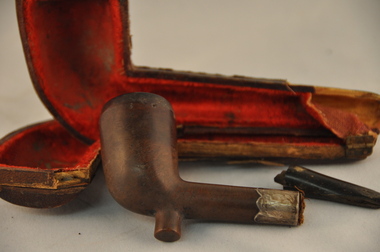
Pipe Tobacco Smoking, Circa 1889
Pipe smoking has been in vogue for centuries, and in Australia it was a symbol of the "discerning smoker" such as the landed gentry or men of professional status. This pipe, of the Standard Canadian style, would have emigrated to Australia with its owner, a reasonable young professional or executive of the Hudson Bay Tobacco Company in the late 1800s or early 1900s. It is the type of pipe well suited to a harsh rural backdrop and with its owner found the Kiewa Valley a more relaxed environment than the Canadian Indian locations. The value of this pipe to the original owner, who would have sealed many trade contracts during the Canadian Indian smoke rituals In the late 1800s, is indicated by the long voyage to Australia and the Kiewa Valley. However with the health related restrictions placed on public smoking in the early 2000s, these tobacco pipes were not immune from the legislation, and even though the pipe smoke was not as offensive as cigarette smoke it still came under the umbrella of smoking. Pipes were also used in the process of inhaling illicit drugs i.e. marijuana, but this use was limited to a very few and not with this pipe. Smoking in the second millennium is being phased out as a social habit in Australia but may affect the few "private" smoker and has, as the United States prohibition era (alcoholic drinks) did, spawn an illicit trade in cheap contraband tobacco. Pipes such as this item show that smoking was not only part of the lifestyle of the era but also that it was part of a ritual (especially to the Indians of the Canada Hudson Bay region) that sealed a brotherhood not only socially but also politically and economically.This type of pipe lends itself well to the rural setting of the Kiewa Valley and although it is a very exclusive pipe it blended into the tobacco industrial environment of the Kiewa Valley and its surrounding districts. The Kiewa Valley region was up until the late 1900s part of the Australian Tobacco industry and the levels of men smoking pipes was enhanced by the readily supply, "off the fields", of tobacco leaves and the attitude to city based smoking restrictions was one of resentment.This pipe has a straight shank and stem and its style is 'standard Canadian'. The pipe has a permanent filter and a stainless steel band with the initials of the Hudson Bay Tobacco Company and its seals stamped on it.. The bowl and shank are one piece of appropriate shaped wood. The bit and bore are made from bakelite (dark brown in colour). The pipe is fashioned in the form of the clay pipes used by trappers, in the late 1800s early 1900s. It has a "rest" lug at the bottom of the bowl similar to clay pipes. This pipe has its own pipe case with wood reinforcement running the entire pipe shaped contour.On the stainless steel at the mortise and tenon junction is stamped "HP" and below that are stamped symbols of a ship's anchor, a lion and a tobacco leaf.tobacco, pipe smoking, smoking accessories -
 Bendigo Historical Society Inc.
Map - GEOLOGICAL MAP OF BENDIGO GOLD FIELD
Two framed laminated maps (a,b) of Bendigo goldfield reef lines, map (b) is a continuation of the reef lines in map (a). On map(a) written in black on top: 'Geological Map, Bendigo Gold Field', Scale of chains, anticlines, synclines, shafts, alluvial and contours marked. Map (b) is continuation of (a). Written on the bottom RH corner of map: 'Prepared in 1923 in the Bendigo Office Mines Department under the direction of H. Herman, Director of Geological Surveys, from surveys by H.S. Whitelaw, Fiield Geologist, assisted by E.S. Usher & J. J. Moore. Re-issued in 1936.'H. Herman, Director of Geological Surveys, from surveys by H.S. Whitelaw, Fiield Geologist, assisted by E.S. Usher & J. J. Moore. Re-issued in 1936.'bendigo, mining, geological map. -
 Kew Historical Society Inc
Map, MMBW, MMBW Plan No.117 Heidelberg & Kew, 1900-1910
The Melbourne and Metropolitan Board of Works (MMBW) was established by an act of the Victorian Parliament in 1890 to prepare for and to implement a sewerage and water reticulation system across what was then inner Melbourne, its surrounding and middle distance suburbs, including Kew. The MMBW was disbanded in 1991.The map collection of the Kew Historical Society has at its core the historic maps assembled and originally stored in the City Engineer's Department of the City of Kew. These include maps in a number of scales. The vast majority of maps were produced by the MMBW in the first two decades of the twentieth century, and are solid working maps, backed by linen for durability. These maps are historically significant to Kew, the City of Boroondara and to the history of the development of state utilities in Victoria. A number of the Kew maps have additional details added by former municipal officers, including the levels reached by various floods. As these were working documents, information was added to them long after the period of their initial production and distribution.Early map of part of the Borough of Kew, created in the early twentieth century, at a scale 160 ft to 1 inch. The map covers what was then the north eastern part of Kew showing the natural landscape and limited development on the south side of the Yarra River. In the Kew section, south of the river, the land is occupied currently by the Greenacres and Kew Golf Clubs. The map shows the extent of urban development by that time and the outlines of the few built structures in the municipality. The height above sea level of all parts of the landscape are indicated numerically in feet. Contour lines and the levels of historic floods were added in ink to the map at a later stage. MELBOURNE AND METROPOLITAN BOARD OF WORKS / PLAN NO. 117 / HEIDELBERG & KEW melbourne & metropolitan board of works, mmbw maps, borough of kew, cartography, mmbw plan no. 117, kew (vic.) -- maps, heidelberg (vic.) -- maps -
 Federation University Art Collection
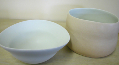
Ceramic, 'Helmet Bowl & Vessel' by Neville French, 2003
Neville FRENCH (1955- ) Born Maryborough, Victoria In 1977 Neville French graduated from Ballarat College of Advanced Education after studying a Diploma in Fine Art (Ceramics) between 1974 and 1976, and was a tutor there for six months in 1978. He holds a Master of Arts, Research (Ceramics) from RMIT Universiy, and was awarded the Vitrify Alcorso National Ceramics Award in 2012. Neville has an international reputation as a ceramics artists and educator. From 1982 to 2012 Neville French was teach and coordinator of the Ceramics department at the Ballarat School of Mines and University of Ballarat (now Federation University). From 1982 to 2012 Neville French taught Ceramics at the Ballarat School of Mines TAFE, which later merged with the University of Ballarat (now Federation University Australia). He completed a Graduate Diploma of Education at Hawthorn State College in 1980, a Certificate of Stoneware Glazes from Brisbane College of Advanced Education in 1983 and a Master of Arts Fine Art (Ceramics) at RMIT University in 2000. Between 2010 and 2012 Neville French taught post graduate honours and masters Ceramics students. During his time as a student at Ballarat Neville Bunning would collect clay from the Enfield clay pit. He described following white tyre tracks to find the location. He described the clay as silky smooth and and fired to a beautiful grey colour at stoneware tempreture. When blended with terracotta clay from Nerrina or fireclay from Bacchus Marsh a wide range of different bodies could be created. This item is part of the Federation University Art Collection. The Art Collection features over 2000 works and was listed as a 'Ballarat Treasure' in 2007.Two vessels made as a sculptural pair. Statement: "My work involves an exploration of elemental vessels - extending porcelain to develop taut contours and spatial dynamics. I seek to distill an essence of purity to evoke notions of quietude and transendence through the expressive use of glaze and its relationship to form, tactility, weight and light. Forms are wheel-thrown, altered and slowly scraped to develip a soft line and solidity. Coloured matt glazes are layered and fused to the porcelain body through multiple firings to give expression and luminosity to the surface,. The iodosyncratice nature of glaze stimulates the imagination. It evokes associations with the natural environement and alludes to a meditative infinity."Signed on base 'f.'art, artwork, neville french, french, ceramics, porcelain, wheelthrown, thrown and altered, alumni -
 Bendigo Military Museum
Administrative record - Geodetic Survey and Topographical Mapping in Australia - Report by BP Lambert 1968, 1968
Australia is governed by a Federal Government and by six State Governments. National coordination of their respective geodetic survey and topographic mapping activities is effected on the advice of a National Mapping Council. Twenty years ago, at least 95% of Australia was poorly mapped and what maps existed were in need of revision. only a small area of the continent was covered by horizontal geodetic control and there was no scheme for a national levelling survey. Over the intervening period there has been an urgent and increasing demand for topographic maps varying from large scale contoured maps in support of specific engineering projects to rapid reconnaissance maps required for mineral prospecting in remote areas. Superimposed on this has been a defence requirement, specifically for military training areas, and generally for maps of the whole country. During the period much progress has been made. This paper reports on the progress from early colonial days through to the present time and finally hazards a prediction of future trends.Photocopy of 18-page typed report including diagrams, stapled top left-hand corner. Geodetic Survey and Topographic Mapping a Report by BP Lambert Director of National Mapping, Department of National Development, Canberra, Australia, 1968.royal australian survey corps, rasvy, fortuna, army survey regiment, army svy regt, asr, national mapping -
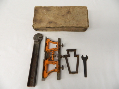 Kiewa Valley Historical Society
Tool Spring Set, circa early 1900s
This is part of a crosscut saw raker/jointer/guage set used to bend the tip of each cutter tooth for cross cut logging saws. The logging saws used in the early 1900's for the clearing of forests required constant sharpening of their "cutting teeth". The logging of forested areas during these times was very much a "hands on" method of either one or two men by the use of saw or hand axe. This item was used by the surveyors commissioned by The S.E.C. Victoria Kiewa Hydro Electricity Scheme project mapping the relevant Alpine region. Chain saws, chain and ball(clearing) and bulldozing methods came in the mid 1900's.This particular saw sharpening method was used by surveyors laying down boundaries for the S.E.C. Victoria Hydro Electricity Scheme (1920's). This item was given to a local Kiewa Valley lad who accompanied the initial surveyors. The lad was responsible for the tendering and feeding of the surveyors "pack horses". Surveys work during this period and in these dense mountainous terrain of the Victorian Alps was both exhausting and hazardous. Overnight accommodation at various log cabins was not always possible and swag/tent alternative was the "fall back".This cast iron Spring Setting tool has a main body of angle iron contours with one end tappered into a flat circular extension with a slit (3/32" wide) running from the top to nearly the centre(15mm). This slit is to allow the bending of each "cutter tooth" of the cross cut saw. The "bottom of this slit has a semi circular ending. Protruding from one side of the bar body, and close to the "slit" is a tounge like extension (wedge) to fasten the spring set tool into a tree stump. See KVHS 0090 (A) for its Raker/Jointer saw sharpening guage set partner. Also see KVHS 0090 (C) for the associated wrench. On one side of the bar "DISSTON U.S.A."hand tool, saw, sharpening method, tree felling -
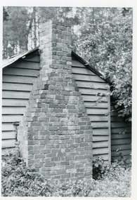 Mt Dandenong & District Historical Society Inc.
Photograph, Rowse Brothers Worman's Cottage, 1972
1972 photograph of the Rowse Brothers workman's cottage built on the bank of the Olinda Creek in 1938.This photograph has a detailed inscription on the back handwritten by John Lundy-Clarke in 1974.Rowse Bros Workman’s Cottage built in 1938 on bank of the Olinda Creek at the 800’ contour on Crown Allotment 925B of materials and bricks taken on demolishing in the same year the house built in 1897 for J.W. Richardson before his marriage to Jeanie Green and their family’s home till 1912 when they went to Queensland. Sold to Rowses in 1913 was Rowse family home till the thirties then workman’s cottage. Chimney built by J. Lundy-Clarke. Picture Dec 1972 by JLC.rowse, workman's cottage, richardson, olinda creek, kalorama, chimney -
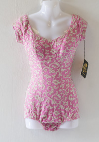 Brighton Historical Society
Swimsuit, late 1950s - early 1960s
Ada of California was a Melbourne swimwear company founded in the early 1950s by Brighton locals Ada and Toni Murkies. Born in Poland in 1922, Ada was 17 when the Second World War reached her doorstep. She and her family were torn from their home by Soviet soldiers and sent to a brutal labour camp in Siberia as part of a series of mass deportations. In order to escape the horrific conditions of the camp, Ada and her sister Barbara joined the Soviet-backed Polish Army. During her time in the military she became close with a handsome young Jewish officer, Lieutenant Antoni Murkies, who later became her husband. After the war Toni was awarded 15 medals including the highest Polish military honour, the Virtuti Militari. Ada was awarded 10 medals, including the Order of the Cross of Grunwald. Emigrating to Australia as postwar refugees in 1948, Ada and Toni arrived in Melbourne with little to their name. Working initially in garment factories and building their connections, by the mid-1950s the couple were able to start a company of their own, with Ada designing the garments and Toni managing the business. Within ten years, Ada of California swimwear was being sold in department stores throughout Australia, and the Murkies family were able to build a permanent home of their own in Brighton. By the early 1980s they had acquired several other major labels, including Watersun. This swimsuit is believed to be one of a large quantity of samples, seconds and unsold Ada Productions stock donated to Brighton Historical Society in late 1990 by Brian Samuel, who worked at the company between 1979 and 1990.Pink short-sleeved one-piece swimsuit with silver lamé embellishment. Sweetheart neckline and low-cut back with metal zip. A black and gold swing tag is attached to one sleeve.Label in bra: “Ada OF CALIFORNIA / MIRACULOUS s-t-r-e-t-c-h BRI-NYLON / 34” Swing tag, front: black with gold text and palm tree logo. “Ada / OF CALIFORNIA / ‘Limited Edition’”. Back: gold with black text. “‘Limited Edition’”. Interior: “Congratulations on your choice of ADA OF CALIFORNIA ‘Limited Edition” Swimsuit contoured for your discriminating taste. / Style 546 / Size 34 / Price £11.9.6”. Care instructions also included.swimwear, ada productions, ada of california, ada murkies, toni murkies, melbourne designers -
 Bendigo Military Museum
Photograph - Stereoscopic Equipment – Army Survey Regiment, Fortuna, Bendigo
This is a set of six photographs of stereoscopic equipment and personnel at the Army Survey Regiment, Fortuna, Bendigo, c1950s to c1960s. The stereoscopes shown in photos .1P and .2P were used to stereoscopically view and interpret features in overlapping aerial photographs. The stereoscopic plotters shown in photos .3P and .4P were used to stereoscopically plot topographic detail from overlapping aerial photographs using a pantograph arm with pencil onto a controlled plotting sheet. The Ryker Model PL-3 Wernstedt-Mahan type stereoscopic plotter shown in photos .5P and .6P was used for precision contouring, planimetry and profiling. It was a comparatively simple stereoscopic mapping instrument designed to use ordinary contact prints of aerial photographs. It provides for plotting on a constant scale and approximate tilt correction but does not provide refinements such as correction for lens distortion. The plotter in Photo .6P does not have its pantograph arm attached. These plotters pre-date the Wild B9 and B8 stereo plotters introduced in the 1960s.This is a set of six photographs of stereoscopic equipment and personnel at the Army Survey Regiment, Fortuna, Bendigo, c1950s to c1960s. Black and white photos are on photographic paper and were scanned at 300 dpi. .1) - Photo, black & white, c1950s to c1960s, Universal Stereoscope, unidentified technician. .2) - Photo, black & white, c1950s to c1960s, Old Delft Scanning Stereoscopes, unidentified technicians. .3) - Photo, black & white, c1950s to c1960s, Unidentified stereoscopic plotters and technicians. .4) - Photo, black & white, c1950s to c1960s, Unidentified stereoscopic plotter, CPL Bill Shapcott. .5) and .6) - Photo, black & white, c1950s to c1960s, Ryker Model PL-3 stereoscopic plotter.Photo .4P is annotated on back - ‘Bill Shapcott (CPL)’royal australian survey corps, army svy regt, rasvy, army survey regiment, fortuna, asr, air survey, photogrammetry -
 Federation University Historical Collection
Plans, Plans of the Ballarat School of Mines, Lydiard Street South, Ballarat, 1953
.3) Ballarat School of Mines plan for water supply installation to prefabricated classrooms associated with the Ballarat Girls' Techncial School, April 1953 .4) Ballarat School of Mines plans for three prefabricated classrooms to be used as the Ballarat Girls' Techncial School, Hickman Street, Ballarat by Percy E. Everett, 16 December 1952. Earthworks undertaken by T.G. James. .5) Ballarat Sewerage Authority Plan of Drainage Prefabricated Class Rooms Ballarat School of Mines by Chief Architect Percy E. Everett, 13 April 1953. The plan shows basket ball court and shelter, classrooms, contours, excavations and girls toilet associated with the Ballarat Girls' Techncial School, Hickman Street, Ballarat. ballarat junior girls' technical school, ballarat girls' technical school, ballarat school of mines, hickman street, white flat, t.g. james -
Bendigo Historical Society Inc.
Document - MERLE HALL COLLECTION: ROSALIND PARK CREATIVE VILLAGE BENDIGO PLAN OF MOSAIC AND TYPICAL REEF CONTOURS, 1990s
MERLE HALL COLLECTION: ROSALIND PARK CREATIVE VILLAGE BENDIGO Plan of Mosaic and Typical Reef Contours 3858.14.pdf contains five pages First Page: Describes the plan the mosaic is a stylised representation of the cenral area of the main Bendigo Goldfield. A typical croos section ogf the Bendigo Goldfield. The mosaic are based on actual mine layouts. The artist has used gold as her inspiration. Second Page: A plan of the mosaic using the atomic structure of gold. Third Page: A plan of the quartz vains winding through the earth, containing gold in its various forms. Fourth Page: A typical reef layout in the Bendigo Goldfields and cross sections. Fifth page: On of the Mosiaic depicking a bird -
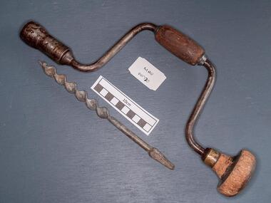 City of Moorabbin Historical Society (Operating the Box Cottage Museum)
Tool - Brace and Bit hand drill, 20thC
Before drills and braces, T-shaped augers were used to poke holes into wood, while smaller gimlets were used to start them. Auger handles were usually made of a piece of hardwood that was sanded, rounded, or even contoured to give the user a firm grip. Bits on spoon augers essentially carved a hole in the piece of wood, and had to be periodically removed to clear the chips. Spiral-bit augers were precursors to modern drills, whose bits cleared the hole of chips as the user drilled. A significant advance on the auger was the brace, which was originally designed with a single, permanently fixed bit at its end. Eventually, though, braces were designed with sophisticated chucks to accommodate replacement bits, as well as bits of different sizes and for various purposes. Chucks were patented as vigorously as the braces themselves The braces themselves also evolved for particular trades, from furniture makers to surgeons. The operator holds the ‘head’ in one hand, positions the drill in the wood , applies pressure and rotates the ‘centre piece’ to cause the drill to pierce the wood. A steel revolving hand tool for boring and screw-driving with wood handles * pioneers, early settlers, market gardeners, moorabbin, bentleigh, cheltenham, brighton, tools, craftsman, carpenters, , blacksmiths, builders, farmers, metalwork, woodwork, screws -
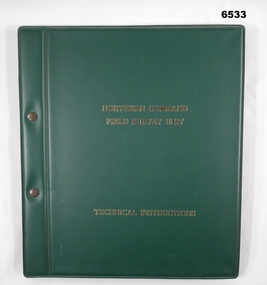 Bendigo Military Museum
Manual - Royal Australian Survey Corps - Northern Command Field Survey Unit Technical Instructions 1966-73, Northern Command Field Survey Unit, Brisbane, Aug 1966 - Feb 1973
The Royal Australian Survey had Field Survey Units located in most States of Australia. Northern Command Field Survey Unit was located in Brisbane. This folder contains technical Instructions for tasks carried out by the Unit from Survey control and data capture through to Field completion. The folder is held together by Chicago screws so that Instructions could be updated when necessary. Instruction No1 Production Data Records Aug 1966 23x pages, Instruction No2 Standard Operating Procedure for B8 Stereoplotting Oct 1967 4 x pages, Instruction No3 Provisional Compilation Specifications 1:100 mapping contouring Oct 1967 (Missing), Instruction No4 Horizontal Control Station Summaries Aug 1972 13 x pages, Instruction No5 Airphotography Mar 1972 8 x pages, Instruction No6 Reconnaisance Station marking and Station Notes Aerodist Operations Mar 1972, 13 x pages, Instruction No7 Field Completion Feb 1973, 7 x pages.A hard green plastic covered manual of 68 x paper pages of typed text diagrams and tables, some fold out Annexes. The pages are held together with two Chicago screwsWhite # "5 " inside front and back coversroyal australian survey corps, rasvy, fortuna, army survey regiment, army svy regt, asr, norther command field survey unit -
 Flagstaff Hill Maritime Museum and Village
Document - Map, Department of Lands & Survey, Victoria / Panmure, 1942
This Emergency Edition of the map of Panmure, Victoria, is part of the W.R. Angus Collection. It was printed in 1942 during World War II. It is one of two maps donated to Flagstaff Hill Maritime Village by the family of Doctor William Roy Angus, who served as Surgeon Captain in the Australian Defence Department. The map was compiled for the Dept. of Army by the Dept. of Lands and Survey in Melbourne, prepared by the Australian Section of the Imperial General Staff, which was a British Government body created in 1907 to co-ordinate the defence of Britain and its Empire. It was printed by A.H.Q. Cartographic Company, Survey Corps, which was formed in 1941. The Corp changed its name to L.H.Q. Cartographic Company of Bendigo. In 1947 the name reverted back to the A.H.Q. Cartographic Company until 1955 when it became the A.H.Q. Survey Regiment. The W.R. Angus Collection includes historical medical equipment, surgical instruments and material once belonging to Dr Edward Ryan and Dr Thomas Francis Ryan, (both of Nhill, Victoria) as well as Dr Angus’ own belongings. The Collection’s history spans the medical practices of the two Doctors Ryan, from 1885-1926 plus that of Dr Angus who began practice in 1924. Dr. Angus served with the Australian Department of Defence as a Surgeon Captain during the Second World Was from 1942 to 1945. He served in Ballarat, Victoria, and in Bonegilla, N.S.W. until he suffering from a heart attack just before the war ended. ABOUT THE “W.R.ANGUS COLLECTION” - Doctor William Roy Angus M.B., B.S., Adel., 1923, F.R.C.S. Edin.,1928, was generally known as Dr Roy Angus. His working life included a position as a doctor with the Flying Doctor Service in Australia’s rural and remote areas. After many varied experiences Dr Angus and his family moved to Warrnambool in 1939 where he purchased “Birchwood,” the 1852 home and medical practice of Dr John Hunter Henderson. He was appointed on a part-time basis as Port Medical Officer in Warrnambool and held this position until the 1940’s when the government no longer required the service of a Port Medical Officer. Dr Angus was a surgeon at the Warrnambool Base Hospital 1939-1942. After further studies he commenced practice as an ophthalmologist in Warrnambool, pioneering in artificial eye improvements. He was Honorary Consultant Ophthalmologist to Warrnambool Base Hospital for 31 years and made monthly visits to Portland to perform eye surgery. Dr Angus and his wife Gladys were very involved in Warrnambool’s community with a strong interest in civic affairs. They were both involved in the creation of Flagstaff Hill Maritime Village, including the layout of the gardens. After his death on 28th March 1970 his family requested his practitioner’s plate, medical instruments and some personal belongings be displayed in the Port Medical Office surgery at Flagstaff Hill Maritime Village, and be called the “W. R. Angus Collection”. This Emergency Edition of the Map of Panmure is significant as an example of the documents prepared for the defence of Australia in World War 2. The Map is also significant for its connection between the Australian Army and the involvement of Dr WR Angus as a Surgeon in the Medical Services during World War II. The W.R. Angus Collection is significant for still being located at the site it is connected with, Doctor Angus being the last Port Medical Officer in Warrnambool. The collection of medical instruments and other equipment is culturally significant, being an historical example of medicine, administration, household equipment and clothing from late 19th to mid-20th century. Dr Angus assisted Dr Tom Ryan, a pioneer in the use of X-rays and in ocular surgery. The collection includes Dr Angus’s Army objects and is significant as an example of items issued to Doctors and Surgeons in the Medical Services of the Australian Army in World War IIMilitary map of Panmure, Victoria, Australia; part of the W.R. Angus Collection. Rectangular coloured map on cream paper for the Australian Army. Details include sea, waterways and land, contour lines, grid lines, names of districts, towns and roads, bridges, swamps, rail lines, cuttings, tracks, buildings (including blacksmiths), pumps, lighthouses, telegraph, telephones and electric transmission lines, and fire stations. The map has margin notes that include distances in miles to nearby towns. The map was compiled for the Dept. of Army by the Dept. of Lands and Survey in Melbourne, prepared by the Australian Section, Imperial General Staff and printed by A.H.Q. Cartographic Company, Melbourne in 1942. Crown Copyright Reserved. Inscriptions in red print state that it is and Emergency Edition and an Official document. An oval purple stamp includes the price.Printed in black; 'Victoria / Panmure", "No. 930 / Zone 6" Printed in red; “EMERGENCY EDITION”, “THIS MAP IS AN OFFICIAL DOCUMENT. IF FOUND, IT MUST BE HANDED / IN TO THE NEAREST MILITARY HEADQUARTERS OR POLICE STATION” Stamped: within concentric ovals (“- - - FOR SALE / PRICE 2/- / - - - - - OF THE ARMY”)flagstaff hill, warrnambool, flagstaff hill maritime museum, maritime museum, shipwreck coast, flagstaff hill maritime village, great ocean road, dr w r angus, dr ryan, warrnambool base hospital, flying doctor, surgeon captain, australian department of defence, royal australian army, world war 2, map panmure 1942, roy angus, port medical officer, nhill base hospital, military map, emergency map, military service australian army, department of army, department of lands and survey, a.h.q. cartographic company melbourne, panmure 1942, australian section, imperial general staff -
 Flagstaff Hill Maritime Museum and Village
Document - Map, Department of Lands & Survey, Victoria / Port Campbell, 1942
This Emergency Edition of the map of Port Campbell, Victoria, is part of the W.R. Angus Collection. It was printed in 1942 during World War II. It is one of two maps donated to Flagstaff Hill Maritime Village by the family of Doctor William Roy Angus, who served as Surgeon Captain in the Australian Defence Department. The map was compiled for the Dept. of Army by the Dept. of Lands and Survey in Melbourne, prepared by the Australian Section of the Imperial General Staff, which was a British Government body created in 1907 to co-ordinate the defence of Britain and its Empire. It was printed by A.H.Q. Cartographic Company, Survey Corps, which was formed in 1941. The Corp changed its name to L.H.Q. Cartographic Company of Bendigo. In 1947 the name reverted back to the A.H.Q. Cartographic Company until 1955 when it became the A.H.Q. Survey Regiment. The W.R. Angus Collection includes historical medical equipment, surgical instruments and material once belonging to Dr Edward Ryan and Dr Thomas Francis Ryan, (both of Nhill, Victoria) as well as Dr Angus’ own belongings. The Collection’s history spans the medical practices of the two Doctors Ryan, from 1885-1926 plus that of Dr Angus who began practice in 1924. Dr Angus served with the Australian Department of Defence as a Surgeon Captain during the Second World Was from 1942 to 1945. He served in Ballarat, Victoria, and in Bonegilla, N.S.W. until he suffering from a heart attack just before the war ended. ABOUT THE “W.R.ANGUS COLLECTION” - Doctor William Roy Angus M.B., B.S., Adel., 1923, F.R.C.S. Edin.,1928, was generally known as Dr Roy Angus. His working life included a position as a doctor with the Flying Doctor Service in Australia’s rural and remote areas. After many varied experiences Dr Angus and his family moved to Warrnambool in 1939 where he purchased “Birchwood,” the 1852 home and medical practice of Dr John Hunter Henderson. He was appointed on a part-time basis as Port Medical Officer in Warrnambool and held this position until the 1940’s when the government no longer required the service of a Port Medical Officer. Dr Angus was a surgeon at the Warrnambool Base Hospital 1939-1942. After further studies he commenced practice as an ophthalmologist in Warrnambool, pioneering in artificial eye improvements. He was Honorary Consultant Ophthalmologist to Warrnambool Base Hospital for 31 years and made monthly visits to Portland to perform eye surgery. Dr Angus and his wife Gladys were very involved in Warrnambool’s community with a strong interest in civic affairs. They were both involved in the creation of Flagstaff Hill Maritime Village, including the layout of the gardens. After his death on 28th March 1970 his family requested his practitioner’s plate, medical instruments and some personal belongings be displayed in the Port Medical Office surgery at Flagstaff Hill Maritime Village, and be called the “W. R. Angus Collection”. This Emergency Edition of the Map of Port Campbell is significant as an example of the documents prepared for the defence of Australia in World War 2. The Map is also significant for its connection between the Australian Army and the involvement of Dr WR Angus as a Surgeon in the Medical Services during World War II. The W.R. Angus Collection is significant for still being located at the site it is connected with, Doctor Angus being the last Port Medical Officer in Warrnambool. The collection of medical instruments and other equipment is culturally significant, being an historical example of medicine, administration, household equipment and clothing from late 19th to mid-20th century. Dr Angus assisted Dr Tom Ryan, a pioneer in the use of X-rays and in ocular surgery. The collection includes Dr Angus’s Army objects and is significant as an example of items issued to Doctors and Surgeons in the Medical Services of the Australian Army in World War IIMilitary map of Port Campbell, Victoria, Australia; part of the W.R. Angus Collection. Rectangular coloured map on cream paper for the Australian Army. Details include sea, waterways and land, contour lines, grid lines, names of districts, towns and roads, bridges, swamps, rail lines, cuttings, tracks, buildings (including blacksmiths), pumps, lighthouses, telegraph, telephones and electric transmission lines, and fire stations. The map has margin notes that include distances in miles to nearby towns. The map was compiled for the Dept. of Army by the Dept. of Lands and Survey in Melbourne, prepared by the Australian Section, Imperial General Staff and printed by A.H.Q. Cartographic Company, Melbourne in 1942. Crown Copyright Reserved. Inscriptions in red print state that it is and Emergency Edition and an Official document. An oval purple stamp includes the price.Printed in black; 'Victoria / Port Campbell", "No. 932 / Zone 6" Printed in red; “EMERGENCY EDITION”, “THIS MAP IS AN OFFICIAL DOCUMENT. IF FOUND, IT MUST BE HANDED / IN TO THE NEAREST MILITARY HEADQUARTERS OR POLICE STATION” Stamped: within concentric ovals (“- - - FOR SALE / PRICE 2/- / - - - - - OF THE ARMY”)flagstaff hill, warrnambool, flagstaff hill maritime museum, maritime museum, shipwreck coast, flagstaff hill maritime village, great ocean road, dr w r angus, dr ryan, warrnambool base hospital, nhill base hospital, flying doctor, surgeon captain, map port campbell 1942, roy angus, port medical officer, military map, emergency map, australian department of defence, royal australian army, military service australian army, department of army, department of lands and survey, world war 2, a.h.q. cartographic company melbourne, australian section, imperial general staff, port campbell 1942 -
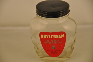 Kiewa Valley Historical Society
Jar Brylcream- Personal Item, Circa mid 1900s
This product was introduced in an era where the "silky smooth" look was in vogue. From the 1920s on, American and British film stars set the tone of how clean cut (hero type) masculine look attracts the opposite sex faster and in greater quantities than the "unkempt" or natural maintained look. This look was bold and "polished" and had the intended projection that the hair matched the character of "I look after myself and have a high opinion of physical appearances". As fashion goes this slick and well maintained look has circled many times, in and out of history and in Australia in the 1950s this was a prime example. The liberation of the stereo type of both sexes occurred in the 1960s when the freedom loving "hippie culture" had a marked affect upon the city inhabitants but not so strong among rural males. Sexism was still rife in that time frame.This jar of Brylcreem was a part of the (masculine) rural scene for a longer period than that found in the larger towns and cities. The long held "men are men" and "women are women" distinction between the sexes lingered on more in rural areas because of the perceived physical differences, mainly "strength" and perceived tasks such as "men only" activities (heavy farm/mining/construction). The jar of Brylcreem maintained the respectable male look for those special occasions when males "dressed" up and looked clean physically and well behaved (to show respect to the women folk)This glass jar with a glued on,red background, label detailing the product Brylcreem (a men's) hairdressing ointment is empty of its original product. It has been contoured on each side to allow for a man's fingers to comfortably and firmly grip the jar. This form would allow even "greased up" hands to maintain control. The glass thickness is far greater than needed and also added the extra stability to the standing jar. The shape of the jar is a latent attempt to emulate the physique of a fit young man (small waist, expanded and muscled mid rift and large shoulders). The jar does not distract from viewing its contents (clear glass). It has a black gloss screw (on/off) lid made from mild grade steel. The jar holds approximately 200 grams of a thick molasses textured product. On the front red Label; in large white letters "BRYLCREEM" underneath this is in smaller silver print "THE PERFECT HAIRDRESSING" underneath this is a banner type motif with a crown at the top and a black letter "B"in the centre. Below this and in much smaller print are printed in black script "BEECHAM (AUSTRALIA) PTY. LTD. MELBOURNE VICTORIA M A Imen's deportment, toiletries, men's hair styles, physical appearances -
 Whitehorse Historical Society Inc.
Functional object - Post Box
Receiver was obtained from Supply Branch of Telecom Australia. It was located by Harold Bakes (early member of the Nunawading Historical Society) at the Hawthorn Line depot and Society purchased. It was stored at the former City of Nunawading Depot in Station Street, Nunawading. It was noticed by Postal Services when they were building the Nunawading Mail Exchange and loaned to them whilst it remained in the City of Nunawading at the Mail Exchange. The had it refurbished and it stood in the Mail Exchange vestibule. When the exchange closed it was taken to Dandenong. It took much negotiation before it was returned to the Society.Alternative Name: Letter Receiver Large round cast iron Letter Receiver surmounted with a gold crown on domes to pointed top. Top has a gold cast iron fancy fringe and below on the main body a further gold plain fringe. Door follows the contour of the round receiver and cover about on of the body. Handle of door is in shape of a fist painted gold. Receiver is mounted on a cast iron base (could have been all cast together) approx 3/8 of the overall height of 250cm. Receiver is painted Pillar Box Red - base which is placed in ground is mid green. From a similar Receiver installed near the Prahran Railway it would appear that half of the base is above ground. Station It has five oblong holes. Cast into the body between the two fringes are a letter opening and two words POST OFFICE and Receiving Pillar.Cast into Receiver - POST OFFICE / Letter Receiver In door - transfer with crown and E11Rcommunication, postal, historical society -
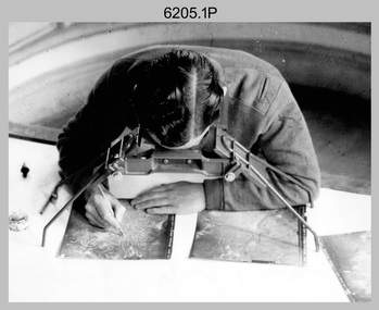
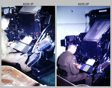
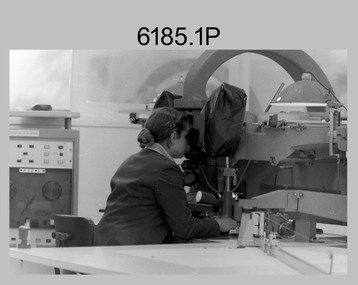 Bendigo Military Museum
Photograph - Capturing Topographic Features with a Wild B8 – Army Survey Regiment, Fortuna, Bendigo, c1980
These four photographs of SPR Santina (Argetto) Straube capturing topographic features – plotting with a Wild B8 stereo plotter were most likely taken in c1980. Introduced in 1966, the Wild B8 stereo plotter was used for plotting topographic detail and contours. These analogue machines were manually controlled by adjusting the control knobs for the orientation of the 3D image. The B8s used a nine-inch square photo image on a film or glass diapositive which allowed highly accurate extraction of map features. At first, plotting by B8 and B9 equipment was undertaken at the aerial photography scale of 1:80,000 in pencil onto a controlled plotting sheet. Sheets were then inked up and reduced photographically to the 1: 100,000 publication scale for scribe impression production. In these photos SPR Santina (Argetto) Straube was plotting with a pencil or ink pen mounted at the far end of the pantograph arm. The plotting procedure was upgraded to direct plotting in ink with photographic reduction to publication scale. In 1975 four B8s were upgraded with tri-axis locaters as part of the Input Sub-system to enable digital extraction to AUTOMAP 1’s topographic database. When AUTOMAP 2 was introduced in 1982 these B8s were upgraded, and additional machines added to expand the Army Survey Regiment’s digital capture capability. This is a set of four photographs of a technician capturing topographic Features with a Wild B8 stereo plotter in Air Survey Squadron – Army Survey Regiment, Fortuna, Bendigo. 1980. The photographs were on 35mm negative film and were scanned at 96 dpi. They are part of the Army Survey Regiment’s Collection. .1) to .4) Photo, black & white, c1980. SPR Santina (Argetto) Straube operating a Wild B8 stereo plotter..1P to .4P – no annotations.royal australian survey corps, rasvy, army survey regiment, army svy regt, fortuna, asr, air survey, photogrammetry -
Bendigo Historical Society Inc.
Map - GEOLOGICAL MAP: BENDIGO GOLD FIELDS
GEOLOGICAL MAP - BENDIGO GOLD FIELDS - Donated by JOHN HORWOOD. Two geological maps of the Bendigo Gold fields. The maps display , reef lines, Hills, Dams and mine locations. Also Anticlines, sinclines, shafts, alluvial deposits, contours and gullys. All items are superimposed on a map of the major roads and streets of Bendigo. The maps were printed by The Victorian Minister for Mines in 1923 and re-issued in 1936. The maps have been specifically framed and donated to The Bendigo Historical Society Inc. in May 2015 for display at Specimen Cottage. John had been a student at The School of Mines- Bendigo and found them useful as a student living in Bendigo. Prior to being framed , the maps have been kept rolled up in his home. Accession Number 309/15 Were on Display at Specimen Cottage 2015 - 2020. After all items removed from SC to the BRAC in 2021 the framed maps could not be located. Search ongoing. BP 2.3.2023Victorian Minister of Minesgoldfields -
 Mt Dandenong & District Historical Society Inc.
Photograph, Isaac Jeeves First Home On Running Creek 1917, 1917
Enlargement of photograph taken by Norman Rowse in 1917 that shows the first home of Isaac Jeeves built at the Running (Olinda) Creek. This photograph has a detailed inscription on the back handwritten by John Lundy-Clarke in 1974.Enlargement of photo taken by Norman Rowse in 1917 of the group of buildings erected as his first home by Isaac Jeeves at the 800° contour on the Running (Olinda) Creek on Crown Allotment 925A. The small building on the right behind the pony and the fowls was Isaac’s first substantial home and was occupied in 1858 he having lived in camp on the creek as a miner since 1855. The tall building on left was barn built in the sixties and the large roof behind was the five roomed house with a tree fern floor. This last building was of blackwood entirely above the floor and was built in the early sixties. The two old homes were pulled down by the Rowses in 1918 and the tree fern floor was pulled up by Len Childs in 1933.norman rowse, isaac jeeves, len childs, running creek -
 Bendigo Military Museum
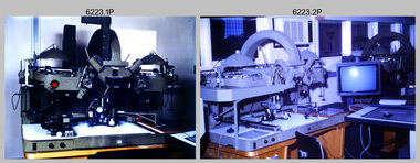
Photograph - AUTOMAP 2 Production - Army Survey Regiment, Fortuna, Bendigo, c1986
This collection of 23 photos of map production on the AUTOMAP 2 computer-based system in Air Survey and Cartographic Squadrons, was most likely taken in 1986. The AUTOMAP 2 system was an upgrade to the AUTOMAP 1 system, comprising Intergraph graphic edit workstation terminals networked to VAX 750/785 main frame computers. Unlike AUTOMAP 1, operators could display digital topographic features on monitors for editing. Successful adaptation of this system meant RASvy was at the forefront of digital mapping/cartographic systems in Australia and overseas. The system comprised Input (Wild B8 Aviograph feature extraction) Raster Scanning (digitising from compilation sheets, Graphic Edit (cartographic completion) and Plot Verification Sub Systems. The system was operational from 1984 to its ‘Newheart’ upgrade in 1993. Throughout its life, the system was progressively refined with productivity gains, achieved from award winning technical development in-house by talented and innovative Army Survey Regiment personnel.This is a set of 23 photograph of AUTOMAP 2 production at the Army Survey Regiment at Fortuna, Bendigo, c1986. The photographs were on 35mm colour slides and were scanned at 96 dpi. Photos .5P and .6P are also printed on photographic and scanned at 300 dpi. They are part of the Army Survey Regiment’s Collection. .1) - Photo, colour, c1986, AUTOMAP 2 Production - Army Survey Regiment, Fortuna, Bendigo. c1986. .2) - Photo, colour, c1986, AUTOMAP 2 Wild B8 Aviograph stereoplotter. .3) - Photo, colour, c1986, AUTOMAP 2 Wild B8 Aviograph stereoplotter feature extraction, unidentified technician. .4) - Photo, colour, c1986, Wild B8 Aviograph stereoplotter feature extraction, LCPL Raelene (Munting) Brodie. .5) - Photo, colour, c1986, AUTOMAP 2 computer tape maintenance, SPR Steve Linane. .6) - Photo, colour, c1986, AUTOMAP 2 Graphic Edit Workstation, SPR Steve Linane. .7) to .8) - Photo, colour, c1986, AUTOMAP 2 Graphic Edit Workstation, unidentified technician. .9 to .10) - Photo, colour, c1986, AUTOMAP 2 Graphic Edit Workstation. .11) - Photo, colour, c1986, AUTOMAP 2 Graphic Edit Workstation feature coding and command menu. .12) - Photo, colour, c1986, AUTOMAP 2 high resolution computer monitor. .13) to .16) - Photo, colour, c1986, AUTOMAP 2 production output comparison to AUTOMAP 1. .17) to .18) - Photo, colour, c1986, AUTOMAP 2 computer system components. .19) - Photo, colour, c1986, AUTOMAP 2 Intergraph 7596 verification plotter. .20) - Photo, colour, c1986, AUTOMAP 2 Benson verification plotter, SPR Steve Coulson. .21) - Photo, colour, c1986, AUTOMAP 2 drainage, contour, roads and cultural digital data verification plot. .22) - Photo, colour, c1986, AUTOMAP 2 drainage, contour, roads and cultural digital data on computer monitor. .23) - Photo, colour, c1986, AUTOMAP 2 3D digital terrain model on computer monitor. .1P to .23P - Some of the equipment is annotated on the frame of the 35mm slides. .5P & .6P prints annotated incorrectly ‘Steve Lenane’. Correct spelling is - ‘Steve Linane’ royal australian survey corps, rasvy, army survey regiment, army svy regt, fortuna, asr, automap 2 -
 Footscray Community Arts
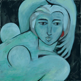
Oh Matise, Jo Darvall, (exact); 2006
MEDIUM: Acrylic on canvas. DESCRIPTION: Blue and black, no external frame. A figurative nude, the close up takes most of the canvas. It sits on a dark background in undefined surroundings. The blue woman sits flat as many of Matisse’s works do, favouring this style over the illusionistic depth to achieve his aim, here we see this replicated. Matisse is also noted for his use of colour as a means of expression rather than description. Here we have a woman painted all in blue, with this knowledge we could say the artist has painted his subject as someone who has been captured in a very relaxed, very calm version of herself, an ocean onto herself, mysterious and captivating in this moment. Her arm slung confidently above and around her head, her view directly facing the viewer provocatively. The only other colour on her other than the thick black lines which outline and shadow her contours, is the circular red of her earring -mirroring the generous sweeping curves of the work. The presence of visible brushstrokes produces a sense of movement and energy as well as providing a decorative quality to the painting.Signed and dated on bottom proper left of center of image (on reverse of canvas).acrylic, darvall, matisse -
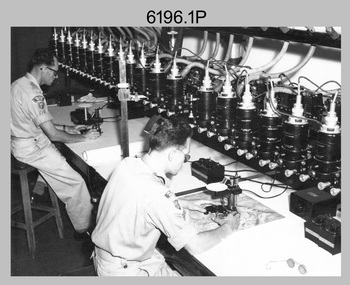 Bendigo Military Museum
Photograph - Multiplex mechanical stereoplotting equipment, Army Survey Regiment, Fortuna Bendigo, c1950s
This is a set of five photographs of Multiplex mechanical stereoplotting equipment at the Army Survey Regiment, Fortuna Bendigo. c1950s. Multiplex equipment was imported from the UK in 1951 and introduced in the following year, to accelerate map production output covering CMF training areas at 1:25,000 map scale. Multiplex plotting was a productive advancement replacing the ‘Arundel’ method of graphical plotting planimetric detail that was expensive and slow, especially in timbered mountainous terrain. Air photos were made into small diapositives and mounted on racks in the exact position relative to when the aerial photos were taken. The technicians operated the Multiplex in a darkened room, with one photo projected with a green filter and the other through a red filter to form a 3D view of the overlapping photos. The 3D model projected onto a platen, which was a small platform that was raised up and down. The technician viewed the 3D image with special glasses fitted with red and green lenses. In the centre of the platen was a small pinhole that served as a floating mark, with a vertical pencil located exactly below the pinhole. This tracing table was moved to follow the topographic feature or contour line and draw it on the paper underneath. The technician raising or lowering the platform’s floating mark to match the height of the 3D terrain. It also replaced the slotted template method of mechanical adjustment of strips of aerial photography, however was restricted to each strip rather than between strips in the block. Although the Multiplex was phased out of production in 1968, it was used in the training of photogrammetry and aero-triangulation at the School of Military Survey located at Bonegilla, Victoria until the early 1990s. The history of the Multiplex is covered in more detail with additional historic photographs, in pages 50 to 51 of Valerie Lovejoy’s book 'Mapmakers of Fortuna – A history of the Army Survey Regiment’ ISBN: 0-646-42120-4.This is a set of five photographs of Multiplex mechanical stereoplotting equipment at the Army Survey Regiment, Fortuna, Bendigo. c1950s. The photographs were printed on photographic paper and are part of the Army Survey Regiment’s Collection. The photographs were scanned at 300 dpi. .1) - Photo, black & white, c1950s, unidentified personnel operating Multiplex equipment. .2) - Photo, black & white, c1950s, Multiplex equipment. .3) - Photo, black & white, c1950s, Multiplex components identified. .4) - Photo, black & white, c1950s, Multiplex optical components. .5) - Photo, black & white, c1950s. Unidentified technician laying down individual Multiplex plots..1P to .2P, .4P – No annotations. .3P annotations identifying Multiplex components on front of photo. .5P annotated on front ‘Lay down of individual Multiplex plots at 1/14000 to framework of master grid to form Composite Compilation Sheet – Material Duralex.’royal australian survey corps, rasvy, army survey regiment, army svy regt, fortuna, asr, photogrammetry -
 Bendigo Military Museum
Photograph - Cartographic Production – Army Survey Regiment, Fortuna, Bendigo, c1960 -1975
This is a set of 10 photographs of Cartographic Squadron technicians undertaking map production tasks in at the Army Survey Regiment, Fortuna, Bendigo circa 1968 to 1975. Production was undertaken on the top floor of Fortuna Villa. The Fotosetter type setting machine shown in photos .1P and .2P. replaced the letterpress method of type production in 1956. CPL Arty Lane specialised in the operation of the Fotosetter type setting machine for many years. For more information on the Fotosetter, see page 71 of Valerie Lovejoy’s book 'Mapmakers of Fortuna – A history of the Army Survey Regiment’ ISBN: 0-646-42120-4. The computer based Editwriter Model 7500 typesetting system shown in photos .3P and .4P. was introduced in 1975 as a replacement to the aging Fotosetter. It was operated by a specialised technician, who generated a large variety of map type styles and sizes quickly and reliably, as well as text panels. Output on Copy proof adhesive backed stripping type film replaced messy wax and spray adhesives in 1978. The Editwriter capability supported all RASvy units and its contractor type setting requirements. The Aristo Co-ordinatorgraph shown in photos .5P to .7P was introduced in 1962. It was a large heavy steel framed light table with a scribing head that moved in a XY direction using a vernier calibrated measuring scale to 0.001 of an inch. Whilst hand operated it was much quicker and accurate than manual grid and graticule calculation, plotting and scribing. The history of co-ordinatorgraphs is covered in more detail with additional historic photographs, in pages 50 to 51 and page 88 of Valerie Lovejoy’s book 'Mapmakers of Fortuna – A history of the Army Survey Regiment’ ISBN: 0-646-42120-4. The scribing process as shown in photos .8P to .9P was the cartographic process of drafting features such as drainage, relief, vegetation, roads and culture on specially coated map reproduction material. The cartographic technician scribed out the map feature such as a contour to a specified line width on the map sheet, using a tool affixed with a sapphire tipped cutter. The quality control edit (Proving) stage of map production shown in photo .10P was the first opportunity to independently and systematically inspect a proof of the map.This is a set of 10 photographs of cartographic Squadron technicians undertaking map production tasks at the Army Survey Regiment, Fortuna, Bendigo, c1968 to c1975. The photographs were on 35mm colour slides and scanned at 96 dpi. They are part of the Army Survey Regiment’s Collection. .1) to .2) - Photo, colour, c1968, Fotosetter type setting machine, CPL Arty Lane. .3) to .4) - Photo, colour, c1975, Typesetting machine, ‘Editwriter’ Model 7500. .5) - Photo, colour, c1960s, PTE Desi Asaris and CPL Kalen Sargent operating Aristo Co-ordinatorgraph equipment. .6) - Photo, colour, c1970s, L to R: CPL Desi Asaris, CPL John Bennett, operating Aristo Co-ordinatorgraph equipment. .7) - Photo, colour, c1970s, L to R: CPL John Bennett, CPL Desi Asaris operating Aristo Co-ordinatorgraph equipment. .8) - Photo, colour, c1970s, L to R: CPL Desi Asaris scribing drainage, CPL John Bennett. .9) - Photo, colour, c1970s, CPL Desi Asaris scribing drainage. .10) - Photo, colour, c1970s, L to R: CPL Desi Asaris, CPL John Bennett and their supervisor WO2 Roger Rix inspecting features on an aeronautical chart proof. .1P to .10P There are no annotations stored with the 35mm slides.royal australian survey corps, rasvy, army survey regiment, army svy regt, fortuna, asr, carto -
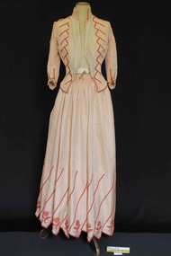 Brighton Historical Society
Clothing - Dress, Afternoon dress, c.1890
This afternoon dress belonged to Clara Johnstone Miller (nee Bell, 1866-1910). Clara was the only daughter of Mr James Bell, a councillor of the Shire of Leigh (today a part of Golden Plains Shire) and owner of Woolbrook Homestead in Teesdale, near Geelong. In 1888, Clara married prominent businessman, racehorse owner, racing identity and pastoralist Septimus Miller (1854-1925). Septimus was the sixth of seven children born to Henry 'Money' Miller and Eliza Miller (nee Mattinson). 'Money' Miller was a well known financier and politician and reputedly one of Australia's wealthiest people in his time. In 1889, Clara and Septimus moved into the house 'Cantala' in Dandenong Road, Caulfield. They had one child, Gwendoline Stewart Miller, who died in 1902 at the age of thirteen of diabetes - a largely untreatable condition at the time (insulin would not be discovered until 1921). Clara died in 1910, aged only 44. Septimus subsequently married Helen (nee Henderson), with whom he had a son, Ronald (1915-1990). The Millers were buried in the Brighton General Cemetery in a large Gothic-style vault. Upon Clara's death, Septimus sent much of her clothing and Gwendoline's to her mother Mary Bell. Some of these items were passed down to two of Clara's nieces, Miss Mary Bell and Mrs Lois Lillies, who donated them to BHS around 1973.A salmon (pale orange pink) corded silk afternoon dress with orange beaded embellishments, consisting of a bodice (.1) and skirt (.2) from c.1890. The bodice features a high standing collar with triple pleated bone silk chiffon trim along the top line, under the chin. This same chiffon is also secured in two pieces gathered and secured under the collar and and at the waist adding volume over the bust line and partially obscuring the jacket closing. The chiffon is secured at the side into the main fabric of the bodice by the beaded embellishment. The pink seed beads are sewn in lines of five beads one after the other creating a diagonal design that tapers from the shoulder to the waist. The bodice is boned around the front and back and secured down the centre font by nineteen hook and eyes and additional cotton tapes. Further beading details the bottom centre front and base line of the bodice. The shoulders have been repaired with replacement fabric to match, from our records it appears that the repair work was performed in circa 1974 but no record exists of the original shoulder design and if the repair was an exact copy of the original. The repaired shoulders feature a small frill around the shoulder yoke and top of the arm. The sleeve is fitted and three quarter finishing just below the elbow. The base of the sleeve is also trimmed with the pink bead design and bone three pleat chiffon trim. The back of the bodice features shaped panels contouring the jacket neatly in at the waist and then splitting and splaying out over the fullness of the skirt. The skirt appears to have been floor or ankle length held at the waist by a wide waistband. The skirt openings have been altered from the original currently featuring two openings secured by press studs. The skirt is gathered to the waistband at front and back creating fullness. The lower part of the skirt features the same pink bead embellishment and additional beaded flowers and diagonal point edge detail.clara miller, woolbrook, septimus miller, henry 'money' miller, gwendoline miller, cantala, 1890s fashion, caulfield, brighton general cemetery -
 Eltham District Historical Society Inc
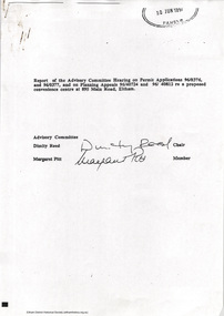
Document - Report, Dimity Reed et al, Advisory Commlttee Hearing on Permit Applications 96/0376, and 96/0377, and on Planning Appeals 96/40724 and 96/40812 re a proposed convenience centre at 895 Main Road, Eltham, June 1997
On 15 December 1994 the former Shire of Eltham ceased to exist following the Liberal Kennett Government local council amalgamations. A new Nillumbik Shire Council was established with unelected commissioners appointed. That Council sold the former Eltham Shire Council Offices and land at 89S Main Road Eltham to Dallas Price Homes Pty. Ltd. the sale being conditional upon the granting of a planning permit for a petrol station/convenience store, fast food and video outlet. The sale was conditional that if the permit was not granted by 30 August. 1997, the contract could be avoided by either the purchaser or the vendor. The proposed development consisted of a petrol station with undercover fuelling facilities, convenience shopping, a drive through service facility for fast food, an 80 seat cafe, automated banking, a children's play area and retail space. In addition, the proposal included a 200 square metre community facility for Council use, provision of on site carparking over 2 levels for 83 vehicles, and advertising signage. The Advisory Committee was appointed under Section 151 of the Planning and Environment Act 1987 to hear submissions on the proposal to develop the land at 895 Main Road Eltham, the site of the former Eltham Shire Offices. In September 1996, two applications were made by Contour Consultants Australia Pty Ltd on behalf of Dallas Price Homes Ply Ltd, to Nillumbik Shire Council. After extensive notification, the Council received 213 objections and a petition of over 1400 signatures. On October 9, 1996, Nillumbik Shire Council issued Notices of Decision to Grant Permit on Applications number 96/03376 and 96/0377 for the use and development of the land as a convenience Centre consisting of a petrol station, convenience store, cafe/takeaway food premises, a retail facility and a community facility, with associated advertising signs. Objectors to the proposals lodged Planning Appeals number 96/40724 and 96/40812 with the Administrative Appeals Tribunal on November 1, 1996. The grounds of appeal can be summarised as: inappropriate development, insufficient carparking, traffic and access issues, unsatisfactory design, inadequate permit conditions, the proposal being out of character with the area. and being contrary to the purpose and orderly development of the Eltham Town Centre, excessive noise, lack of consultation and unsuitable signage. On November 13, 1996, the Minister for Planning and Local Government directed the Registrar of the Administrative Appeals Tribunal. under Section 41 (1) (a) of the Planning Act 1980, to refer the Appeals to the Governor in Council for determination without a hearing or recommendation by the Tribunal. The Minister for Planning and Local Government called in the Appeals as he considered that they raised major issues of policy relating to the facilitation of development in accordance with the objectives set out in Section 4 of the Planning and Environment Act 1987, and that determination of the Appeals could have a substantial effect on the achievement of these planning objectives. The Minister required the Advisory Committee to consider the planning merits of the proposed use and development, and to address the issues raised in the objections. The Advisory Committee was required to produce a report providing: • The Committee's response to the matters detailed; • Relevant supporting information for the Advisory Committee's recommendation; and • A description of the proceedings conducted by the Advisory Committee and a list of those consulted or heard by the Committee. In March 1997, elections were held in the Shire of Nillumbik and the view of the new Council to this proposal differed from the view held by the earlier Council Hence the Submission made to the Committee by the Shire was against the decision by the Shire of Nillumbik to issue the Notices of Decision to Grant a Permit. The Recommendations of the Advisory Committee were: i. The cafe and take away food premises are as of right uses and are therefore allowable, but that shop and petrol station are unacceptable uses. A community facility is a discretionary use and is acceptable. ii. A development of the type and scale proposed is totally inappropriate for this land and that the Applications number 96/03376 and 96/0377 for the use and development of the land as a convenience Centre consisting of a petrol station, convenience store, café/takeaway food premises, a retail facility and a community facility, with associated advertising signs, be refused. iii. The land should be rezoned for public purposes and should remain in the community's ownership for community use. 895 main road, advisory committee, dallas price homes, eltham, eltham shire office, nillumbik shire council, planning application, administrative appeals tribunal -
 Southern Sherbrooke Historical Society Inc.
Information folder - Glen Park
Folder containing information pertaining to the history of Glen Park homestead, Menzies Creek. Contents: -two pages photocopied from "That Little Train" by Peter Cuffley, showing four photos of Glen Park homestead and a short history of Edwin Johns at Glen Park (2 copies of each) -articles, "No. 861's full steam ahead again", photo shows Col Rees with Coonara Community School students, and "Living the dream" re. engine no. 861. On verso, "A Family Reunited", article by Emerald Tourist Railway re. locomotives, and "Colin just loves steam locomotion" re. engine no. 861. -4 letters, from Puffing Billy Railway, in support of Col Rees. -Letter, dated 19 June 1996, from Emerald Tourist Railway, re. appeal for restoration of Garratt engine. On verso, copy of certificate awarded to Col Rees for donation to appeal. -Letter, 1 June 1998, re. Garrett appeal. On verso, certificate awarded to Col & Kellie Rees for donation to appeal. -Aerial photo showing proposed property boundaries of Glen Park subdivision. -Aerial photo showing existing property boundaries of Glen Park. NB. last four items provided to society by Col Rees in support of subdivision. -Memorandum dated 2 May 2000 from Graham Whitt, Shire of Yarra Ranges, to Shire Service Centres, re proposed division of Glen Park land. -Fax, dated 13 June 2000, from Southern Sherbrooke Historical Society to Shire of Yarra Ranges, re. intention to make submission. -Letter, dated 14 June 2000, acknowledging receipt of above fax. -Submission, dated 18 June 2000, from Southern Sherbrooke HS, expressing concern re. proposed subdivision of Glen Park. -Fax, dated 27 June 2000, from Dianne Kueffer to Susan Heywood-Downard, Agenda Item 2 of the Yarra Ranges Planning Committee Agenda 14 March 2000, including detailed description of proposed subdivision and map. -Letter, dated 7 July 2000, Shire to Society, re. discussion of Glen Park subdivision by council. -Letter, dated 7 July 2000, Society to Shire, re. withdrawal of objection subject to certain conditions. -Letter, dated 14 July 2000, Shire to Society, re. council resolution to allow subdivision of Glen Park. -Letter, dated 24 October 2000, Shire to Society, stating that amendment to Planning Scheme allowing subdivision was approved by council and gazetted on 19 October 2000. -seven A3 sheets, showing house and property plans for new constructions proposed for Lot 1 of Glen Park subdivision. -diagram, hand-drawn (by Col Rees?) on lined A4 sheet, showing proposed development. -A1 sheet, Plan of feature survey of Lot 2 Blackhill Rd, Selby, dated 12 April 2000, showing contours, vegetation, proposed location of buildings, etc. -Glen Park Homestead and Cyprus Avenue, document prepared for the Shire Of Yarra Ranges by Helen Lardner Conservation & Design P/L, June 2003edwin johns, breen family, col & kellie rees, puffing billy