Showing 291 items
matching early farming
-
 Greensborough Historical Society
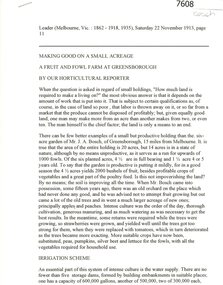
Newspaper - Newspaper Clipping (copy), Leader (Melbourne), Making good on a small acreage 1913, 22/11/1913
An article about the small fruit and fowl farm at Greensborough owned by Mr J. A. Bosch in 1913, with detail on farming methods.Mr J. A. Bush was formerly known as Johannes Adem Bosch, an early Greensborough orchardist. He changed his name during World War 1.4 pages, copy of newspaper article.Edited by S. Ballantyne28/02/2021.plenty river, bosch family, bush family, farming, orchardists -
 Koroit & District Historical Society
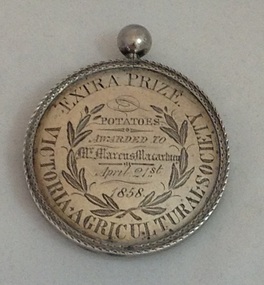
Victorian Agricultural Society Medal, 1850's
This medal, dated 1858, was awarded to local farmer Marcus Macartney by the Victorian Agricultural Society on the 21 April 1858, for the prize 'PotatoesThe medal is of local historical significance"for its association with the early promotion of agriculture in Victoria through public shows and competitions in the 1850's; and its link to the emergence of the Koroit-Tower Hill area,with its rich volcanic soil, as a properous farming district, especially for potato-growing." (Helen Doyle, Significance Assesment: Koroit & District Historical Society.)Circular medal with small knob on top.Äround circumference/""EXTRA PRIZE VICTORIAN AGRICULTUREAL SOCIETY. Engraving on medal "Potatoes/Awarded To/Mr Marcus Macartney /April 21st/1858 Reverseägricultural shows, potatoes, koroit, tower hill -
 Koroit & District Historical Society
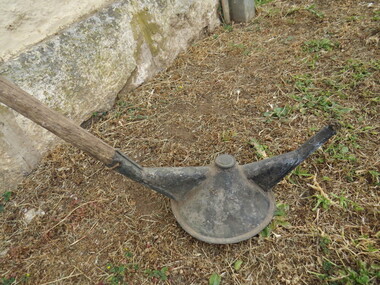
Tussock burner
... of the kind of hand tools used during the period of early farming ...This hand tool was used to reduce tussock grass by burning. It comprised of a long wooden handle with a wick and fuel container at one end. This kind of implement was used in the early 20th Century up until around the 1940s.The tussock burner is of local historical significance as an example of the kind of hand tools used during the period of early farming in the Koroit district. The significance is increased by its possible connection to Joseph Patrick Lee, farmer of Wangoom.The tussock burner is a long handled tool with a fuel burner at one end. farming implements, tussock, burner, tools, wangoom, st mary's farm -
 Phillip Island and District Historical Society Inc.
Newspaper clippings
Arrival of George Bass at Westernport - History of John Cleeland and his farming & horse racing interests. Quarrying at Cape Woolamai. Loss of Ketch Kermandie.Article on arrival of George Bass at Westernport - early history of John Cleeland including his farming and horse racing interests.local history, documents, newspapers, newspaper clipping, george bass, john cleeland, black & white newspaper clipping, george bass, john cleeland, mrs cleeland, ketch kermandie, shenandoah, lt james waddell. -
 Phillip Island and District Historical Society Inc.
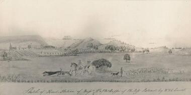
Photograph, Bryant West
One of a collection of over 400 photographs in an album commenced in 1960 and presented to the Phillip Island & Westernport Historical Society by the Shire of Phillip IslandPhotograph of a Sketch of Head Station of Messrs. W & W J McHaffie by W. & E. Liardet. Copy of water colour by Victoria's earliest artist late 1840's.Hand written inscription by W. J. McHaffie - "Sketch of Head Station of Mssrs. W & J.M. McHaffie of Phillip Island by W.F.E. Liardet."local history, photography, photographs, painting, early settlement, black & white photograph, farming, settlement, mchaffie, john jenner, bryant west -
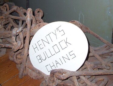 Glenelg Shire Council Cultural Collection
Functional object - Chains - bullock harness, n.d
Thought to be the chains used for the Henty's bullock harness. The Henty family are known as Victoria's earliest European settlers and pastoralists, emigrant squatters who played a defining role in the establishment of Portland and the development of the region's wool trade. Facing challenges as a farmer in early 19th-century England, West Sussex grazier Thomas Henty (1775–1839) turned his sights south to the colonies, where he believed his seven sons would have a brighter future as sheep breeders and wool producers. He had been the first to introduce merino to the south of England, and would do so in the colonies also.Thought to be the chains used for the Henty's bullock harness.Iron chains with fittings for bullock harnesses.farming, rural industry, henty, bullock, chains -
 Greensborough Historical Society
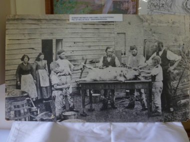
Photograph, Robert Whatmough and family slaughtering pig at Willis Vale Greensborough. 1870, 1870_
... . Early evidence of farming and animal husbandry ...Robert Whatmough and family lived at Willis Vale from approx 1863 to 1878. Willis Vale was later owned by the Partington family. In this photograph the family is involved in butchering a pig. The people have been identified as: Mary (Hill) Whatmough b1813; and her daughter Rosalie b1856; Grandpa John Wilson; Joseph Wilson b1835; Emmett Whatmough b1842; John Thomas Fielding b1860; James Fielding b1861; Robert Whatmough b1815; [Sarah Whatmough b1845 m1866 Joe Wilson b1835 8 children]. Photo and article also appeared in The Diamond Valley News 9/10/1984 page 26.Early evidence of farming and animal husbandry in the Greensborough area.Black and white photograph, enlarged and mounted on timber backing.Typed caption pasted on front of photograph: 'Robert Watmaug [sic Whatmough] and family slaughtering pig at Willis Vale Greensborough.' Identification of those in photo by Faye Fort 2015.robert whatmough, whatmough, willis vale, greensborough, wilson -
 Greensborough Historical Society
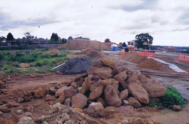
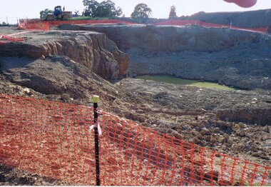
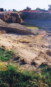
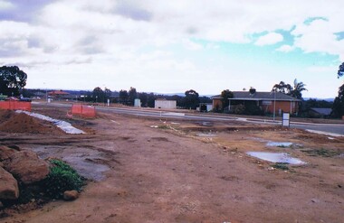
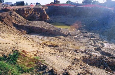
Photograph - Digital image, Frank Solomon, Development of pig farm to residential blocks, 1, 02/08/2009
A view of the redevelopment of the pig farm in Weidlich Road Greensborough, owned by Werner Hanusch. The land was used as a pig farm and quarry from 1954 and this photo shows early stages of the land being subdivided into the Evelyn Way estate. This project of fifty, one double storey, dwellings was commenced on 2/8/2009 and completed on 6/2/2011.An example of the changing land use in Greensborough, from farming to residential.Digital copy of colour photographwerner otto fritz hanusch, pig farm st helena, weidlich road greensborough, one evelyn way greensborough -
 Greensborough Historical Society
Photograph - Digital image, Frank Solomon, Development of pig farm to residential blocks, 2, 02/08/2009
A view of the redevelopment of the pig farm in Weidlich Road Greensborough, owned by Werner Hanusch. The land was used as a pig farm and quarry from 1954 and this photo shows early stages of the land being subdivided into the Evelyn Way estate. This project of fifty, one double storey, dwellings was commenced on 2/8/2009 and completed on 6/2/2011.An example of the changing land use in Greensborough, from farming to residential.Digital copy of colour photographwerner otto fritz hanusch, pig farm st helena, weidlich road greensborough, one evelyn way greensborough -
 Greensborough Historical Society
Photograph - Digital image, Frank Solomon, Development of pig farm to residential blocks, 3, 02/08/2009
A view of the redevelopment of the pig farm in Weidlich Road Greensborough, owned by Werner Hanusch. The land was used as a pig farm and quarry from 1954 and this photo shows early stages of the land being subdivided into the Evelyn Way estate. This project of fifty, one double storey, dwellings was commenced on 2/8/2009 and completed on 6/2/2011.An example of the changing land use in Greensborough, from farming to residential.Digital copy of colour photographwerner otto fritz hanusch, pig farm st helena, weidlich road greensborough, one evelyn way greensborough -
 Greensborough Historical Society
Photograph - Digital image, Frank Solomon, Development of pig farm to residential blocks, 4, 02/08/2009
A view of the redevelopment of the pig farm in Weidlich Road Greensborough, owned by Werner Hanusch. The land was used as a pig farm and quarry from 1954 and this photo shows early stages of the land being subdivided into the Evelyn Way estate. This project of fifty, one double storey, dwellings was commenced on 2/8/2009 and completed on 6/2/2011.An example of the changing land use in Greensborough, from farming to residential.Digital copy of colour photographwerner otto fritz hanusch, pig farm st helena, weidlich road greensborough, one evelyn way greensborough -
 Greensborough Historical Society
Photograph - Digital image, Frank Solomon, Development of pig farm to residential blocks, 5, 02/08/2009
A view of the redevelopment of the pig farm in Weidlich Road Greensborough, owned by Werner Hanusch. The land was used as a pig farm and quarry from 1954 and this photo shows early stages of the land being subdivided into the Evelyn Way estate. This project of fifty, one double storey, dwellings was commenced on 2/8/2009 and completed on 6/2/2011.An example of the changing land use in Greensborough, from farming to residential.Digital copy of colour photographwerner otto fritz hanusch, pig farm st helena, weidlich road greensborough, one evelyn way greensborough -
 City of Moorabbin Historical Society (Operating the Box Cottage Museum)
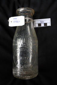
Manufactured Glass, milk bottle 'Black Rock Dairy', 20thC
... in Eliza Street, Black Rock, Victoria. Dairy farming ...Alfred R Varcoe was a dairyman with stables, cart shed and his house in Eliza Street, Black Rock, Victoria. Dairy farming was established early in the settlement of the Brighton / Moorabbin area following the Dendy's Special Survey 1841 and subsequent land sales c1850. The produce was taken to feed the population of Melbourne and local residents.A clear glass ,1 pint , milk bottle used by Black Rock Dairy, MelbourneTHIS BOTTLE CONTAINS/ MILK / BOTTLED FOR SALE BY / BLACK ROCK MODEL / DAIRY / BLACK ROCK / BOTTLE IS THE PROPERTY OF THE ABOVE / IT IS OWNED AND CANNOT BE LEGALLY USED BY OTHERS/ ONE IMPERIAL PINT on base 440market gardeners, early settlers, farmers, dairies, milk production, moorabbin shire, moorabbin, cheltenham, black rock, brighton, dairy farmers, bottles, glass manufacture, varcoe alfred r; black rock dairy, dairy farmer, dairy products sales and deliveries, -
 Dunkeld Museum Inc.
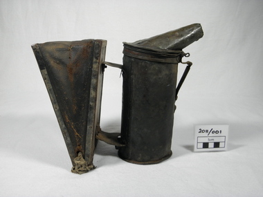
Bee Smoker
Many farming families in the district kept bees as a source of honey for home consumption. This item was made for use on the family farm. Most of the equipment used in the local industry was homemade.During the early to mid 20th century bee keeping was a significant rural industry in Dunkeld and surrounding districts. It is believed that there were nearly twenty apiarists operating in the area. Honey in large quantities was railed to Melbourne for sale.Homemade bee smoker consisting of a copper cylindrical firebox and rectangular bellows constructed of wood and leather. Components are assembled with rivets, scrap wire, sheet metal, nuts and bolts and nails. -
Glenelg Shire Council Cultural Collection
Photograph - Photograph - Portland Show, n.d
Black and white photo taken from glass plate negative. Crowd at Portland Show. Dress late 19th, early 20th Century. Photo glued onto heavy card.Front: Portland Show - White Portland Show - black textaportland show, rural show, portland, recreation, farming -
 Eltham District Historical Society Inc
Photograph, Edendale Farm, Eltham Heritage Tour, 24 May 1992, 24/05/1992
ELTHAM HERITAGE TOUR The Society excursion on 24th May 1992 was arranged by David Bick, leader of the team carrying out the Shire's heritage study. David selected a number of sites or buildings identified in the study, some of them lesser known components of the Shire's heritage. The tour commenced at the Eltham Shire Office at 10.00 am. Travel was by private car and mini-bus with stops at about twelve locations for commentary by David.It included a short walk in Hurstbridge and lunch at Kinglake. Highlights of the tour included: - 10 am Leave from Shire Offices - 3 Important Trees - A Physical Link to Eltham's First Settlers - Toorak Mansion Gates - A Surviving Farm House - An Intact Circa 1900 Main Street - First Settlers - Gold Miners, and Timber-getters - An Early Hotel - A Pioneering Homestead - Changing Eltham Shire - 20th Century - 4 pm Afternoon Tea and Finish Tour Extract from ELTHAM CULTURAL HERITAGE TOUR (Newsletter No. 85, July 1992, by Bettina Woodburn) "The land was unprofitable for intensive farming, but there was always water in the Diamond Creek. The railway, a technological advance, followed the valley, and was provided to transport produce. At North Eltham we were privileged to tour a surviving farmhouse of the 1860-70 era at the Shire’s Edendale Farm, with the as yet unfinished Sculpture for a front fence - bulbous tree-trunks decorated with salt pots, with cross members from the old trestle bridge. As was usual these six veranda posted houses faced South (or East, away from the sun!) with the scullery, kitchen and pantry "out the back". The veranda, which must have been very narrow, no longer exists. It probably wrapped around three sides. The drive took us past the Dutch Windmill, only twenty years old and in the Shire of Diamond Valley, then the Diamond Creek Cemetery with impressive gateway, to a detour to see another old farmhouse, isolated on a hill off Murray Road Wattle Glen. Here was a particularly thick patch of exotic planting of pines and cypresses. Subsistence farming no longer pays. Following the rail-line we noticed on the left near Silvan Road an Edwardian cottage and on the right near Yates Road the old school residence for this Upper Diamond Creek area."Record of the Society's history and activities and highlighting various aspects of the Heritage Study undertaken by David Bick used to create the future heritage overlay for the Shire of Eltham and later Nillumbik Shire.Roll of 35mm colour negative film, 4 stripsKodak Gold 100 5095eltham, shire of eltham historical society, activities, heritage tour -
 Kiewa Valley Historical Society
Photograph of Kiewa Valley Panorama, Farming lands within the Kiewa Valley in1950s, Circa 1950
This photograph shows how (early to mid1900s), before the establishment of the Mount Beauty "gated" village, the Kiewa Valley was farmed and the scarce population was spread out over acres of productive land. This photograph catches a time before (what appeared to the local farmers as the invasion by a mass of construction workers) when this remote valley was part of a "lay back" rural landscape,occasionally visited by friends and some wayward tourists. The mountain ranges provided an adequate barrier against the way-would traveller. The immigration numbers coming into Australia was still quite small ( due to the "white" Australia policy) which was in force before World War II. After World War II a mass of displaced European refugees and migrants boosted the Australian population and provided for a greater degree of diverse professions and rural related work force.This photograph depicts the borderline in time between an exclusively rural based population and respective activities(early 1900s)to the present (2000 on wards) integrated village, tourist and retiree/holiday area. The time when land was exclusively used in agriculture is over and the impact of cheaper rural produce from Asian markets will see a shift of land useage and population activities. The Kiewa Valley is loosing its hiding place and is becoming more and more a source of untapped residential land. Black and white photograph of farming/grazing land useage, before the establishment of the Mount Beauty Village. Small pockets of residentual houses can be viewed. Road access (unsealed dirt) was typical of that provided in rural regions in the 1950s. The photo is on 200gms paper and not on photographic paper.kiewa valley in the early1900s, grazing in the kiewa valley, sec victoria -
 Kiewa Valley Historical Society
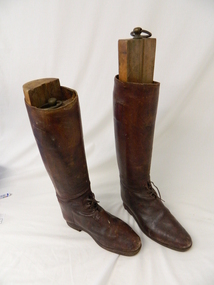
Boots Riding, late 1800's - early 1900's
... because the mark a period of early farming within the Kiewa Valley ...The early Kiewa Valley farmers opened up the Bogong High Plains for cattle grazing in the late 1800's and early 1900's. Many farmers of the Kiewa Valley built huts on the Bogong High Plains to stay in during the summer mustering season. The Roper family had their own cattle run on the High Plains with several version's of Ropers Hut being built and used for this purpose. These boots were owned by Fred Roper whose father was one of the first pioneers of the Upper Kiewa Valley and Tawonga farming district. These boots were made around the late 1800's to early 1900's and are of a quality hide and a very good example of historical clothing worn at the time. These boots are very significant to the Kiewa Valley because the mark a period of early farming within the Kiewa Valley and Bogong High Plains as they were worn by Fred Roper who comes from one of the farming pioneering families of Tawonga. These boots were used when mustering the families cattle up to the Bogong High Plains for summer grazing and also around his farm in Tawonga when riding his horses. They were donated by his great grand daughter Leonie Roper in 2011, therefore the manufacturing of these boots could be anything from the late 1880's to early 1900's. They are made of high quality leather and were made to last the tough conditions of mustering and farming cattle. They also had wooden stock which fitted into them "KVHS 0445"These knee high "riding" boots have a 4 "rung" laces at the base of the upright boot and a strap at the top of the boot. They are made of brown leather and have a small heel (not the usual higher heel for stirrups)riding boots. footwear. cattle mustering footwear. roper family. cattlemen. bogong high plains. -
 Kiewa Valley Historical Society
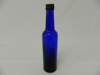
Bottle - Castor Oil, Circa 1920's to 1900's
... Valley as it demonstrates the self reliance of the early farming ...This bottle of castor oil was used during the mid to late 1900's when there was a Hospital in the Kiewa Valley, but regarded as only for serious injuries and near death situation. For this reason many households had a "first aid" box full of items such as this bottle of castor oil. Home based remedies for non life threatening injuries and illnesses were a part of life in a semi remote rural region. True and trusted family "health" remedies were passed from generation to generation.This Castor Oil bottle is very significant to the Kiewa Valley as it demonstrates the self reliance of the early farming and grazing pioneer families. Knowledge of "first aid" was uppermost to the survival of families before the late 1900's. Naturopathic remedies such as connected with the castor oil contained in this bottle, although may not be sanctioned by medical research, does not take into account of the positive "self healing" of the human mind (if you think it is doing you good it creates a positive action). Such preservation techniques were handed down through the generations.Medical Reference material was limited to books available and read and not not from "the internet" in the latter part of the 1900's. The availability of General Practitioners increased because of the boost in the population growth (SEC Vic Hydro Electricity Scheme) in the Kiewa Valley from 1940's onward. This small indigo coloured glass bottle has a narrow neck and a screw on lid.It has an embossed manufacturer's name and contents (Castor Oil) on one side and identification marks embossed on the underside base.medicine bottles, home first aid remedies, indigo glass medicine bottles -
 Eltham District Historical Society Inc
Photograph, Edendale Farm, Eltham Heritage Tour, 24 May 1992, 24/05/1992
ELTHAM HERITAGE TOUR The Society excursion on 24th May 1992 was arranged by David Bick, leader of the team carrying out the Shire's heritage study. David selected a number of sites or buildings identified in the study, some of them lesser known components of the Shire's heritage. The tour commenced at the Eltham Shire Office at 10.00 am. Travel was by private car and mini-bus with stops at about twelve locations for commentary by David.It included a short walk in Hurstbridge and lunch at Kinglake. Highlights of the tour included: - 10 am Leave from Shire Offices - 3 Important Trees - A Physical Link to Eltham's First Settlers - Toorak Mansion Gates - A Surviving Farm House - An Intact Circa 1900 Main Street - First Settlers - Gold Miners, and Timber-getters - An Early Hotel - A Pioneering Homestead - Changing Eltham Shire - 20th Century - 4 pm Afternoon Tea and Finish Tour Extract from ELTHAM CULTURAL HERITAGE TOUR (Newsletter No. 85, July 1992, by Bettina Woodburn) "The land was unprofitable for intensive farming, but there was always water in the Diamond Creek. The railway, a technological advance, followed the valley, and was provided to transport produce. At North Eltham we were privileged to tour a surviving farmhouse of the 1860-70 era at the Shire’s Edendale Farm, with the as yet unfinished Sculpture for a front fence - bulbous tree-trunks decorated with salt pots, with cross members from the old trestle bridge. As was usual these six veranda posted houses faced South (or East, away from the sun!) with the scullery, kitchen and pantry "out the back". The veranda, which must have been very narrow, no longer exists. It probably wrapped around three sides. The drive took us past the Dutch Windmill, only twenty years old and in the Shire of Diamond Valley, then the Diamond Creek Cemetery with impressive gateway, to a detour to see another old farmhouse, isolated on a hill off Murray Road Wattle Glen. Here was a particularly thick patch of exotic planting of pines and cypresses. Subsistence farming no longer pays. Following the rail-line we noticed on the left near Silvan Road an Edwardian cottage and on the right near Yates Road the old school residence for this Upper Diamond Creek area."Record of the Society's history and activities and highlighting various aspects of the Heritage Study undertaken by David Bick used to create the future heritage overlay for the Shire of Eltham and later Nillumbik Shire.Roll of 35mm colour negative film, 4 stripsKodak Gold 100 5095eltham, shire of eltham historical society, activities, heritage tour -
 Eltham District Historical Society Inc
Photograph, Edendale Farm, Eltham Heritage Tour, 24 May 1992, 24/05/1992
ELTHAM HERITAGE TOUR The Society excursion on 24th May 1992 was arranged by David Bick, leader of the team carrying out the Shire's heritage study. David selected a number of sites or buildings identified in the study, some of them lesser known components of the Shire's heritage. The tour commenced at the Eltham Shire Office at 10.00 am. Travel was by private car and mini-bus with stops at about twelve locations for commentary by David. It included a short walk in Hurstbridge and lunch at Kinglake. Highlights of the tour included: - 10 am Leave from Shire Offices - 3 Important Trees - A Physical Link to Eltham's First Settlers - Toorak Mansion Gates - A Surviving Farm House - An Intact Circa 1900 Main Street - First Settlers - Gold Miners, and Timber-getters - An Early Hotel - A Pioneering Homestead - Changing Eltham Shire - 20th Century - 4 pm Afternoon Tea and Finish Tour. Extract from ELTHAM CULTURAL HERITAGE TOUR (Newsletter No. 85, July 1992, by Bettina Woodburn) "The land was unprofitable for intensive farming, but there was always water in the Diamond Creek. The railway, a technological advance, followed the valley, and was provided to transport produce. At North Eltham we were privileged to tour a surviving farmhouse of the 1860-70 era at the Shire’s Edendale Farm, with the as yet unfinished Sculpture for a front fence - bulbous tree-trunks decorated with salt pots, with cross members from the old trestle bridge. As was usual these six veranda posted houses faced South (or East, away from the sun!) with the scullery, kitchen and pantry "out the back". The veranda, which must have been very narrow, no longer exists. It probably wrapped around three sides. The drive took us past the Dutch Windmill, only twenty years old and in the Shire of Diamond Valley, then the Diamond Creek Cemetery with impressive gateway, to a detour to see another old farmhouse, isolated on a hill off Murray Road Wattle Glen. Here was a particularly thick patch of exotic planting of pines and cypresses. Subsistence farming no longer pays. Following the rail-line we noticed on the left near Silvan Road an Edwardian cottage and on the right near Yates Road the old school residence for this Upper Diamond Creek area."Colour photograph1992, culture, edendale, edendale community farm, events -
 Kiewa Valley Historical Society
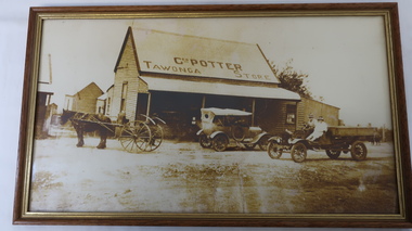
Photo - Tawonga Store Geo. Potter
The Tawonga Store was a general store in the Upper Kiewa Valley providing for the farming community. This store had a variety of items and was the main store for many of the farming families who would travel in on horse and cart to make weekly trips to the store for supplies.George Potter owned the store before 1920. Whit Potter, George's son worked with his father for many years. See KVHS 0621 for early Ledgers, which give a comprehensive list of what type of items the residents of the Kiewa Valley purchased during this period.Rectangular sepia photo of Tawonga Store with Geo. Potter printed on its roof. Horse and cart and one early model car and one truck are parked out the front. The truck has a driver and passenger.tawonga store, george and whit potter -
 Kiewa Valley Historical Society
Posters - "Tawonga Remembers" x 5
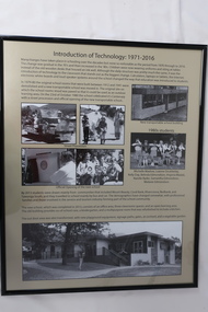
The town of Tawonga is in the Kiewa Valley surrounded by farmland. It is adjacent to Mt Beauty (built from 1946), an SECV town built for the workers on the Kiewa Hydro Electric Scheme which was being constructed from 1911-to 1961. Tawonga consisted of essential amenities including a store, school, butter factory, sporting facilities, post office, hall and hotel. Activities involved sport, social get togethers eg. dances, fundraising, CWA etc.The posters are a collection of historical photos, documentation and information regarding the history of the town of Tawonga, which is the centre of a farming community in the Kiewa Valley.Posters framed with thin black plastic strip, covered by glass. Each one has a title re "Tawonga Remembers" and includes print and photos in black and white. Beige background. 1.Butcher Shop and Slaughter Yard; 2. Tawonga Saw Mill; 3. Post Office; 4. Tawonga District Hospital (2 pages); 5. Introduction of Technology: 1971-2016tawonga, photos of early tawonga, kiewa valley, tawonga remembers, businesses -
 Kiewa Valley Historical Society
Posters - "Tawonga Remembers" x 5
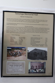
The town of Tawonga is in the Kiewa Valley surrounded by farmland. It is adjacent to Mt Beauty (built from 1946), an SECV town built for the workers on the Kiewa Hydro Electric Scheme which was being constructed from 1911-1961. Tawonga consisted of essential amenities including a store, school, butter factory, sporting facilities, post office, hall and hotel. Activities involved sport, social get togethers eg. dances, fundraising, CWA etc. The posters are a collection of historical photos, documentation and information regarding the history of the town of Tawonga, which is the centre of a farming community in the Kiewa Valley.Posters framed with thin black plastic strip, covered, by glass. Each one has a title re "Tawonga Remembers" and includes print and photos in black and white. Beige background. 1. Tawonga Memorial Hall 2. Opening of the Second Public Hall 1925 3. Public Hall for Tawonga 4. Tawonga Debutante Ball 1947 5. Tawonga Hall Ghosttawonga, photos of early tawonga, kiewa valley, tawonga remembers, tawonga hall -
 Kiewa Valley Historical Society
Posters - "Tawonga Remembers" x 4
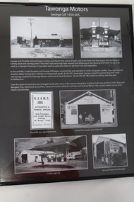
The town of Tawonga is in the Kiewa Valley surrounded by farmland. It is adjacent to Mt Beauty (built in 1946), an SECV town built for the workers on the Kiewa Hydro Electric Scheme which was being constructed from 1911 to 1961. Tawonga consisted of essential amenities including a store, school, butter factory, sporting facilities, post office, hall and hotel. Activities involved sport, social get togethers eg. dances, fundraising, CWA etc.The posters are a collection of historical photos, documentation and information regarding the history of the town of Tawonga,which is the centre of a farming community in the Kiewa Valley.Poster framed with thin black plastic strip, covered, by glass. Each one has a title re "Tawonga Remembers" and includes print and phtots in black and white. Black background. 1. Tawonga SEC Depot; 2. Tawonga Service Station circa 1940s; 3. George Johnston's Taxi Service; 4. Tawonga Motors 1950-60stawonga, photos of early tawonga, kiewa valley, tawonga remembers, transport -
 Kiewa Valley Historical Society
Posters - "Tawonga Remembers" x 4
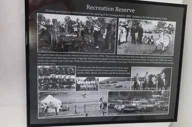
The town of Tawonga is in the Kiewa Valley surrounded by farmland. It is adjacent to Mt Beauty (built from 1946), an SECV town built for the workers on the Kiewa Hydro Electric Scheme which was being constructed from 1911 to 1961. Tawonga consisted of essential amenities including a store, school, butter factory, sporting facilities, post office, hall and hotel. Activities involved sport, social get togethers eg. dances, fundraising , CWA etc.The posters are a collection of historical photos, documentations and information regarding the history of the town of Tawonga, which is the centre of a farming community in the Kiewa Valley.Posters framed with thin black plastic strip, covered, by glass. Each one has a title re "Tawonga Remembers" and includes print and photos in black and white. Black background. 1. Recreation Reserve 2. St Aidan's Church 3. Lois Pearce 4. Boarding Housetawonga, photos of early tawonga, kiewa valley, tawonga remembers, tawonga businesses -
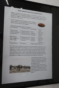 Kiewa Valley Historical Society
Posters - "Tawonga Remembers" x 8
The town of Tawonga is in the Kiewa Valley surrounded by farmland. it is adjacent to Mt Beauty (built from 1946), an SECV town built for the workers on the Kiewa Hydro Electric Scheme which was being constructed from 1911 to 1961. Tawonga consisted of essential amenities including a store, school, butter factory, sporting facilities, post office, hall and hotel. Activities involved sport, social get togethers eg. dances, fundraising, CWA etc. The posters are a collection of historical photos, documentations and information regarding the history of the town of Tawonga, which is the centre of a farming community in the Kiewa Valley.Posters framed with thin black plastic strip, covered by glass. Each one has a title re "Tawonga Remembers" and includes print and photos in black and white. White background. 1. Where and How Kiewa Valley Soldiers Served; 2. Tawonga and Dederang Servicemen; 3. Kergunyah and Gundowring Servicemen and Women; 4. Kiewa and Tangambalanga Servicemen.5. Sacrifice and Honour; 6. The End of the Great War; 7. World War 1914-18; 8. Soldiers in Uniform (Black background and glass cracked) tawonga, photos of early tawonga, kiewa valley, tawonga remembers, ww1