Showing 171 items matching "hillside"
-
 Bendigo Historical Society Inc.
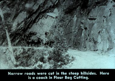
Slide - DIGGERS & MINING. DIGGERS AND MINERS, c1800s
Diggers & Mining. Diggers and miners. Walhalla - Gold Town. Narrow roads were cut in the steep hillsides. Here is a coach in Flour Bag Cutting. Picture show that the cutting is on a very steep incline. There are at least ten men and four horses in the photo. Markings: 19 995 WAL. Used as a teaching aid.hanimounteducation, tertiary, goldfields -
 Flagstaff Hill Maritime Museum and Village
Photograph, March, 1895
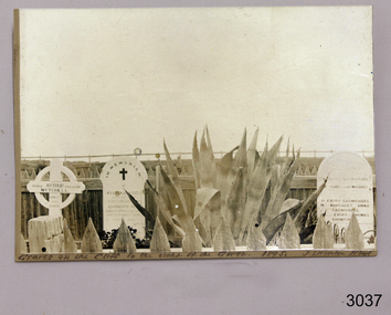
Loch Ard was bound for Melbourne in 1878 loaded with passengers and cargo when it ran into a rocky reef at the base of Mutton Bird Island, near Port Campbell. Of the 54 crew members and passengers on board, only two survived: an apprentice, Tom Pearce and a young woman passenger, Eva Carmichael, who lost all of her family in the tragedy. The wreck of Loch Ard still lies at the base of Mutton Bird Island and much of the cargo has been salvaged. Some was washed up into what is now known as Loch Ard Gorge following the shipwreck. Cargo and artefacts have also been illegally salvaged over many years before protective legislation was introduced. The photograph is significant for its association with the wreck of the Loch Ard. This wreck has been protected as a Historic Shipwreck since 11 March 1982, under the Commonwealth Historic Shipwrecks Act (1976) Flagstaff Hill’s collection of artefacts from Loch Ard is significant for being one of the largest collections of artefacts from this shipwreck in Victoria. It is significant for its association with the shipwreck, which is on the Victorian Heritage Register. The collection is significant because of the relationship between the objects, as together they have a high potential to interpret the story of the Loch Ard. The Loch Ard collection is archaeologically significant as the remains of a large international passenger and cargo ship. The Loch Ard collection is historically significant for representing aspects of Victoria’s shipping history and its potential to interpret sub-theme 1.5 of Victoria’s Framework of Historical Themes (living with natural processes). The collection is also historically significant for its association with the Loch Ard, which was one of the worst and best known shipwrecks in Victoria’s history. The Loch Ard collection meets the following criteria for assessment: Criterion A: Importance to the course, or pattern, of Victoria’s cultural history. Criterion B: Possession of uncommon, rare or endangered aspects of Victoria’s cultural history. Criterion C: Potential to yield information that will contribute to an understanding of Victoria’s cultural history. Photograph of Loch Ard Gorge graves on hillside, including the Carmichael family, Reginald Jones and Arthur Mitchell Reverse has hand writing in pen and ink, part of details are lost due to photo being trimmed. Also has four areas of torn surface, perhaps were photo had been mounted. Reverse has hand writing “ … Loch Ard Gorge / Graves of / the Carmichael family / Mr. Reginald Jones / Mr Arthur Mitchell “ and “Mr J Swinton / March 1895”flagstaff hill, warrnambool, shipwrecked coast, flagstaff hill maritime museum, maritime museum, shipwreck coast, flagstaff hill maritime village, great ocean road, loch line, loch ard, captain gibbs, eva carmichael, tom pearce, glenample station, mutton bird island, loch ard gorge, loch ard shipwreck, carmichael family, arthur mitchell, reginald jones, loch ard gorge graves -
 School of Health and Biomedical Sciences, RMIT University
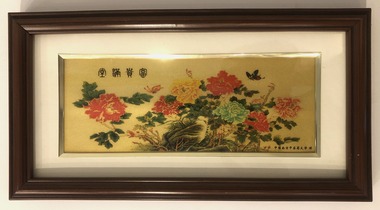
Artwork, other - Chinese reproduction artwork
Small elongated framed floral reproduction artwork in dark brown frame with cream window mount with silver edge. Picture depicts chrysanthemums and a hillside on a gold backgrounds with a butterfly at top right and Chinese script at top left and bottom right corners. Black felt rear face with hinged stand. Signs of warping. chinese corporate collection -
 Whitehorse Historical Society Inc.
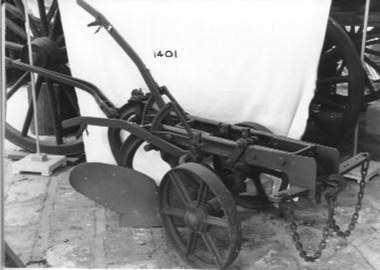
Machine - Plough
Horse drawn one way plough with one share - mould board; two discs, one fluted. Two off set adjustable wheels. Hand steered. adjustable. Suited for dry soil and hillside. Possibly made by Thomas H Corbett of Perseverance Ironworks in Shrewsbury Shropshire who developed a similar plough in 1870s.'V13R and A8178' on the main frame. 'DH53' on rotary blade.|'V5' on handle attachment to frame.rural industry, orcharding -
 Mt Dandenong & District Historical Society Inc.
Photograph, Fox's Point Scenic Railway c1955, c1955
Shows tracks up the hillside with passengers riding in carriage down the short course railway at Kalorama. The railway was built around 1950, initially to carry building materials. It was burnt in the 1962 bushfires. Phil McClure gave a talk to the Historical Society 15/8/2009. As a teenager he had assisted with 'Foxie's' operation of the railway.fox's point, scenic railway, stanley neil fox-croft, kalorama -
 Hume City Civic Collection
Photograph, c Early 1990's
The Kaolin quarries at Bulla were an important industry in the district and supplied clay products to the Cornwell and Hoffman companies in Brunswick. The Kaolin deposits were found in the 1850's and were considered to be some of the largest in the colony.A landscape photograph of a valley with a post and wire fence and a partial view of a farm gate in the immediate foreground. A clump of native trees are on the LHS and a small grove of almond trees has been planted on the river flat. Kaolin quarry is on the hillside and two buildings can be seen on the hill top. High tension pylons are in the distance near the skyline.kaolin quarries, almond groves, bulla township, deep creek, hoffmans kaolin mine, hoffmans potteries, cornwell potteries, george evans collection -
 Southern Sherbrooke Historical Society Inc.
Photograph - Cardinia Creek area, Narre Warren East, prior to dam works
A set of four colour photos showing the area around where Cardinia Reservoir is now located. The photos show various views of the hillsides and valleys prior to the damming of Cardinia Creek. Each photo has 'Belgrave Cardinia Creek' handwritten on the back. They date from prior to May 1970. The set was donated to the society by David Howe. 'Belgrave Cardinia Creek' handwritten on the back of each photo. -
 Melbourne Tram Museum
Magazine, Public Transport Corporation (PTC), Turning Point, 23-10-1997
Magazine - issued by the Public Transport Corporation announcing the split up of The Met into the parts that facilitated the later franchising of the trains and trams. Created Yarra Trams and Swanston Trams and Hillside and Bayside trains. Includes a map of the two systems, lists the senior positions and their names. Includes the launch of Principal Drivers for trains, sporting news, operator performance delivery statistics, Transcom adverts and Bairnsdale line upgrade.Yields inforamation about split up of the PTC in readiness for future franchising. Magazine - three fold to A4 sheet, printed in two colours.tramways, tramcars, yarra trams, swanston trams, ptc, bayside trains, hillside trains, management, managers -
 Lakes Entrance Historical Society
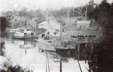
Photograph - Mossiface Wharf, 1908
Black and white photograph showing P S Tanjil left and S S Burrabogie right at Mossiface Wharf on the Tambo river. Larger open sided white shed at wharf, smaller shed further back, pipes on wharf small row boat beside stern of Burrabogie. Hillside partly cleared trees ring barked. East Gippsland Victoriaships and shipping, waterways, wharfs -
 The Beechworth Burke Museum
Photograph, 1907-8
The photo from 1907-8 is a sepia print, depicting a small valley with building at base. There are flumes visible above areas of water, trees on hills and a few small cottages on the hillside. Cock's Pioneer Gold & Tin Sluicing Co NZ No 2 Site. The photo was taken of Matthews Gully looking west. Sluicing was undertaken in the area from 1900 to 1942 with some short breaks between these periods. The image depicts a location mined by Cocks Pioneer Gold and Tin Sluicing Company (as recorded on the annotation on the card mount) The Cocks Pioneer Gold and Tin Mines N.L was one of El Dorado's two largest open cut sluicing mines of the 20th Century. The other was named the Cocks El Dorado Gold Dredging Company. The Cocks Pioneer Mines operated from 1901 until 1941 and found a total of 117,378 ounces of Gold and 1,673 tones of tin concentrates over these years. The Cocks company was formed in 1898 and operated until 1941. Open cut sluicing involved the use of high-powered hoses which used the centrifugal sand pump system (known as hydraulic sluicing) which broke down the soil which was then processed for gold and other precious metals. From 1914 , four years after this image was captured, the company reformed to Cocks Pioneer Gold and Tin Mines NL (previously it was known as Cocks Pioneer Sluicing Co) and undertook large scale sluicing operations until 1929 and then 1934-1941. El Dorado is located on Reedy Creek and is surrounded by forested country to the north and east. It is 20 km east of Wangaratta in Victoria's regional north-east. John Cock was the son of a Cornish minor who arrived in El Dorado in 1858. Cock founded his gold and tin mining company which ran successfully for many years in the El Dorado region. It was an open cut sluicing company because of the abandonment of underground mining after this was deemed too dangerous. In 1935 Cock's El Dorado Company commissioned the floating dredge which is still visible in El Dorado today. The dredge was built by the Thompson engineering works, Castlemaine, and weighed over 2,000 tones and today has a place on the Victorian Registers of historic buildings. Interestingly, the name El Dorado does not derive from the gold in the region, but from the Barambogie pastoral run completed by William Baker in 1840-1841. Gold was discovered in El Dorado 1854 but the gold was too deep for individual prospectors to find, it required the use of heavy machinery.The search for gold is ingrained into the history of Victoria and therefore, images like this one which portray an open cut sluicing site can reveal important information for society and technology for the date when the photograph was taken. This image is of important historical significance for its ability to convey information about sluicing and the methods used to find gold in 1910. It also shows a location where sluicing was undertook which provides insight into the impact of sluicing on the environment at a time when it was done. This image is important for current research into the history of El Dorado, a small regional location near Wangaratta in Victoria's North East. Therefore, this image has the capacity to be beneficial for research into society and the motivations of those living and working in this region during this period and therefore, has social significance. The Beechworth Burke Museum has additional images relating to gold sluicing and El Dorado which can be analysed and studied alongside images like this one.Sepia coloured rectangle photograph printed on gloss photographic paper Reverse: 1997. 2613/ A02613/ No2 site/ Matthews Gully/ Cocks Pioneer G&T. ?? Co NZ/ No2 Site looking West/ 1907-8/ (7)sluicing, hydraulic sluicing, 1907, 1908, mining, cock's pioneer gold & tin sluicing co nz, nz, site no 2, matthews gully, west, valley, building, cottages, hillside, trees, water, gold and tin mine -
 Hume City Civic Collection
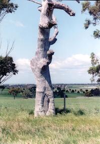
Photograph, early 1990's
The scarred tree is located on a hillside in a local reserve. The bark has been removed in the past to make a boat or other large utensil. Melbourne's skyline can be seen faintly in the distance in the middle of the photograph with local suburban development in the middle distance. The set of 20 photographs were taken of a number of archaeological ands sacred sites in the Bulla district. The photographs were included in a study published by the Shire of Bulla in the early 1990's.A scarred tree aboriginal ring sites, george evans collection -
 Ballarat Tramway Museum
Letter - Letter from Owen to Wal Jack - set of 2, 1954
Wal Jack had an extensive number of correspondents in Australia and around the World. This set of letters are from Owen in Hillside South Australia. 1 - Letter or 22-12-1954 covers topics such as new SAR railcars, breakdown of a railcar, construction of a miniature live steam locomotive and ARHS SA activities. 2 - Letter of 6-1-1955 covers his construction of a miniature live steamer, SAR Railcars and personal matters.Yields information about Wal Jack's correspondence.Set of two letters from Owen to Wal Jack ruled sheets, handwritten in ink. Letters dated 22/12/1954 (three quarto sheets) and 6/1/1955 (two foolscap sheets)letters, wal jack, owen, sar -
 Eltham District Historical Society Inc
Photograph, George Coop, Single Motor Carriage (Red Rattler) Tait train, possibly 471M, heading for Eltham near Allendale Road, Diamond Creek, c.December 1980, 1980
View is looking northwest from the hillside just north of Allendale Road. The long rectangular house in the upper left is No. 22 Challenger Street, Diamond Creek, right at the sharp turn into Price Court. On the track in the straight section heading northwest are two small bridges where the track crosses the Diamond Creek, each fitted with derailment guard rails to prevent severe derailments should a train come off the tracks whilst crossing the culverts. Digital TIFF file Scan of 35mm Ilford FP4 black and white transparency471m, allendale road, challenger street, derailment guard rail, diamond creek, hurstbridge line, price court, red rattler, red rattler single carriage, single motor carriage, tait train -
 Bendigo Historical Society Inc.
Slide - DIGGERS & MINING: THE DIGGINGS - THE DIGGERS, c1856
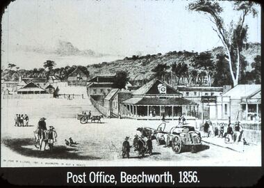
Diggers & Mining: The Digging - The Diggers. Slide reads; Post Office, Beechworth, 1856. Depicts the buildings including other buildings around the post office with the hillside in the background and towns folk in the foreground. Bottom left corner of the picture reads; ON STONE BY A STOPPS FROM A DAGUEREOTYPE BY ACCLEY K ROCWLETZ. Black and white slide. Markings: 44 994.LIF:6. Used as a teaching aid.hanimounteducation, tertiary, goldfields -
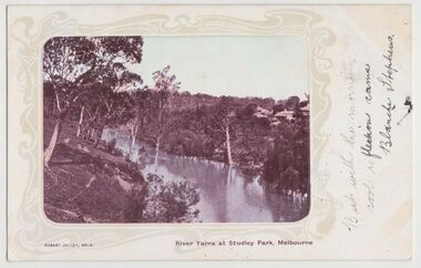 Kew Historical Society Inc
Postcard, River Yarra at Studley Park, Melbourne, 1900-04
Monochrome postcard titled lower right: “RIVER YARRA AT STUDLEY PARK, MELBOURNE”. The postcard was produced by ROBERT JOLLEY, MELB, (active 1900-1904). The photo is positioned to the left of the card and framed by an art nouveau design. A handwritten annotation on the front reads “BUT WITH THE MORNING / COOL REFLECTION CAME / BLANCHE STEPHENS”. On the reverse, there is a handwritten address in black ink to: MISS L STEPHENS / 26 WEST TERRACE / ADELAIDE. There is no division on the reverse of the postcard, dating it to before 1905. It lacks a postage stamp and postmark. Monochrome postcard of the River Yarra in Studley Park. The view is of the Yarra and its banks, with Kew on the left and Abbotsford on the right, as it appeared in the years 1900-1904. On the Abbotsford side of the river, there are a number of weeping willows lining the banks and houses on the hillside. The Studley Park side of the river includes some remnant vegetation and meandering walking tracks. Three very small figures are sitting on the Kew side. "RIVER YARRA AT STUDLEY PARK, MELBOURNE"river yarra -- kew (vic.), postcards -- kew, postcards -- studley park, robert jolley -
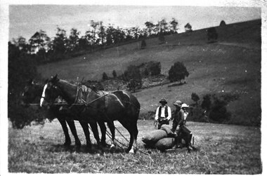 Southern Sherbrooke Historical Society Inc.
Photograph - Bringing in potatoes at Glen Park Farm, Selby, c.1913
B&W photo shows a two-horse team harnessed to a small sled which is laden with bagged-up potatoes. A man wearing dark hat, waistcoat and trousers and a pale shirt is holding the reins of the horses, and two people who could be the Johns children, Percy and Cissie, are seated on the potatoes. The paddock slopes away and another hillside rises in the background. This is most likely Black Hill. dated c.1913. -
 Melbourne Tram Museum
Newspaper, The Age, Sushi Das, "Pledge for safety, style and comfort", 16/07/1999 12:00:00 AM
Newspaper cutting from "The Age Wednesday 16 July 1999 titled "Pledge for safety, style and comfort" about the new investment in public transport vehicles for suburban rail and tram services. Gives information on costs, images of proposed vehicles and some interior images. Notes National Express, Bayside trains, Yarra Trams, Swanston Trams, Metrolink, Hillside Trains and Melbourne Transport Enterprises. Report by Sushi Das Transport Reportertrams, tramways, colour schemes, livery, yarra trams, new trams, swanston trams, national express, hillside trains, bayside trains, metrolink -
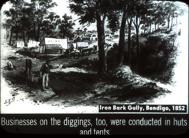 Bendigo Historical Society Inc.
Slide - DIGGERS & MINING. DIGGERS AND MINERS, c1852
Diggers & Mining. Diggers and miners. S.T.G. Iron Bark Gully, Bendigo, 1852. Businesses on the diggings, too, were conducted in huts and tents. Slide depicts the huts and tents at the diggings in which business was conducted. This view you can see there are still quiet a number of trees in the surrounding area, there is also a fence. Miners can be seen walking amongst the tents and huts as well as on the hillside. Markings: 36 994:LIF I. Used as a teaching aid.hanimounteducation, tertiary, goldfields -
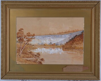 Glenelg Shire Council Cultural Collection
Painting, A.S. Murray, Scene on the River Glenelg, c. 1894
Art Collection Previously located in History HouseThe painting depicts a large body of water surrounded by hills. The body of water extends from the front right corner through to the centre of the work. Predominately depicted in shades of brown, the body of water has a white centre with three birds (swans) sitting on the surface. In the foreground to the left of the water is a riverbank with a large brown tree. The background consists of a large blue/grey hillside and brown cloudless sky. The work has a gilded ornate frame with a gold mount and exposed canvas.Front: A.S. Murray Back: W.HAMER, 189 Sturt Street, Ballarat, VICTORIA BUILDINGS, OPPOSITE CITY FIRE BRIGADElandscape, glenelg river -
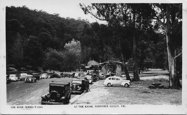 Southern Sherbrooke Historical Society Inc.
Postcard - At The Kiosk, Ferntree Gully, Vic
B&W postcard, Rose Series P.2365, named 'At The Kiosk, Ferntree Gully, Vic.' Photo shows around twenty or more cars parked outside the kiosk in what is now Ferntree Gully National Park Several people are walking and standing in the carpark and on the paths. The kiosk is visible in the background with advertising signs outside, including one for Peters Ice-cream. Closer to the camera is a stone shelter. There are tall trees beside the carpark and in the background of the photo is a heavily treed hillside. The back of the postcard is blank. -
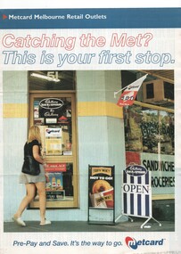 Melbourne Tram Museum
Pamphlet, VicTrip, "Catching the Met? - This is your first stop.", Apr. 1999
Pamphlet - four fold - special size - full colour titled "Catching the Met? - This is your first stop." giving the list of Metcard shops in central and suburban Melbourne, along with maps of the tram and train systems. The maps show both Yarra and Swanston trams with route numbers along with Bayside and Hillside trains and the various ticket zones at the time. The number of car parking spots at each station also shown. On the rear is general information about Metcard with ticket machines, and validators. List dated effective from April 1999.trams, tramways, maps, metcard, yarra trams, swanston trams, hillside trains, bayside trains, tickets -
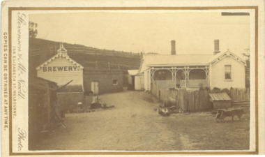 Bacchus Marsh & District Historical Society
Photograph, Symington Brewery, Hopetoun, near Bacchus Marsh 1883
The family of William Symington arrived in Melbourne in 1855. By 1858 they had come to Bacchus Marsh and built a house at Hopetoun a few kilometres east of the town. A brewery next to the house was also built around this time. It was a licensed brewery between 1862 and 1886. The elder William Symington died in March 1867 and the brewery was then operated by his son the younger William Symington for a number of years. It ceased operations sometime before 1900. Small sepia unframed photograph on card with gold border framing photograph. Housed in the album, 'Photographs of Bacchus Marsh and District in 1883 by Stevenson and McNicoll'. The image shows the brewery and house which belonged to the Symington family of Hopetoun, near Bacchus Marsh. The house is a timber structure with two chimneys and a front verandah. The front yard of the house is enclosed by a timber fence. At the front of the fence can be seen a dog kennel. Other tools, such as a wheelbarrow, lie in the yard. The brewery building is of timber and brick. On the hillside behind the buildings are paddocks fenced with post-and -rail fencing.On the front: Stevenson & McNicoll. Photo. 108 Elizabeth St. Melbourne. COPIES CAN BE OBTAINED AT ANY TIME. On the back: LIGHT & TRUTH inscribed on a banner surmounted by a representation of the rising sun. Copies of this Portrait can be had at any time by sending the Name and Post Office Money Order or Stamps for the amount of order to STEVENSON & McNICOLL LATE BENSON & STEVENSON, Photographers. 108 Elizabeth Street, MELBOURNE. stevenson and mcnicoll 1883 photographs of bacchus marsh and district, breweries, symington family bacchus marsh, william symington 1840-1929, william symington 1802-1867 -
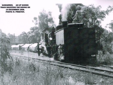 Otway Districts Historical Society
Photograph, R. Preston, Kawarren: an UP goods train, 1958, 14 December 1958
Kawarren was an early timber and limestone loading point. Timber was shipped in by Watson and Facey, Condon Brothers, and Coppock, amongst others, some of which had tramways up to 6.5 km long to the station. Bushfires roared through the area in 1939 and made the area unworkable. An outcrop of limestone existed near Kawarren but it was not until the railway was built that it became workable. 360 metres north of Kawarren station two then three kilns were erected, and later a shed and covered area over a short length of the rail siding in order to prevent rain damage to the lime while it was being loaded. Sluicing was introduced, and the tramway was extended further when the quarry ate deeper into the hillside. Limestone traffic of around 2,000 tonnes each year kept the station busy until the trade ceased in 1957.B/W. On the 14 December 1958 at Kawarren an UP goods train shunts on the siding. A man is talking to the engine driver while another man approaches the engine.kawarren; railways; timber; lime; -
 Linton and District Historical Society Inc
Photograph, Electro Hydraulic Dredge, Snake Valley, 1909
Electro hydraulic dredge Snake Valley 1909. J Mc Bennett, was an engineer back at the main base, at Dawson's dam on the Carngham Road, Between Linton and Snake Valley. These dredges were used for getting gold. The streams of water under high pressure just washed the hills and ground away. This dredge closed down early 1910. 200 H.P. motors were used and 10 in. pumps.Black and white image of three workmen, one beside mining building the other two at dredge pump outlet. Image mounted on dark brown card. Between 1904 and 1911 the Electro Hydraulic Company sought to extract gold in an area north of Linton known as the Hard Hills. By blasting water from high-pressure hoses into the hillsides, soil containing gold was washed out for sluicing. Two gravel pumps in Dawson's Dam pumped the wash through the sluices. Despite considerable investment in expensive equipment, the Company did not have a great deal of success, and the mining operation ceased in 1911.mining, gold, mining equipment, electro hydraulic dredge, dredging, sluicing, dawson's dam, snake valley, miners -
 The Beechworth Burke Museum
Photograph, c1900
Taken around 1858, depicting a row of five business buildings on a rocky, sloping hillside at New Town, with a view across to residences and open land. Businesses included, Joseph E. Bishop, Coach Builders; Straughair Duncan, Engineers, Blacksmiths & Farriers; Straughair Duncan, Beechworth Foundry; Wholesale & Retail Est. 1855, Mackenzie Family Store ; and T. Pratten, Grocer. The Mental Hospital can be seen in the background. Mark Straughair and John Duncan, established the Beechworth Foundry, Newtown in 1858 and went on to build an important industry, employing around sixteen men, after acquiring Alexander Roger's New Ford Street Foundry in the late 1860s. Making and repairing mostly mining and agricultural machinery for the Ovens District and a Beechworth brewery, the business continued to function after Straughair's death in 1882, up until the death of Duncan in 1896, when the business folded. This photograph is historically significant because it shows the development of the businesses in Beechworth from the early establishment of the town.Sepia rectangular photograph printed on photographic paper mounted on boardObverse: [Pin holes from circular tacks in all four corners] Reverse: 84.216-1/ Newtown/ 1997.2650/ 21/ BMM3056/new town, newtown, newtown beechworth, local business, 1858, 1850s beechworth, joseph e. bishop, coach builder, coach, mark straughair, m. straughair, straughair and duncan, john duncan, j. duncan, beechworth foundry, mackenzie family store, t. pratten, grocer, beechworth grocers, beechworth mental asylum, beechworth mental hospital, mayday hills mental asylum, mental hospital, alexander rogers, new ford street foundry, 1860s beechworth, 1860s, mining machinery, agricultural machinery, manufacturing, bridge road -
 Victorian Interpretive Projects Inc.
photograph, Opening of the bew building at Stratford Railway Station, Victoria, c1921, c1921
Stratford railway station is located on the Bairnsdale line in Victoria, Australia. The railway lined opened on 8 November 1887 it served the town of Stratford. The building at the Stratford Railway Station was opened around 1921 after the original building was destroyed by fire on 10 January 1920. "STRATFORD RAILWAY STATION. Mr. M'Lachlan, M.L.A., has received the following from Mr. Norman, late Chairman of the Railway Commissioners:-"In reply to yours, I beg to state that material for the new Stratford railway station has been ordered, and the work will be put in hand as soon as it has been delivered. It is not an easy matter at the present time to obtain materials, and I cannot say exactly when those required will be received." (Gippsland Times, 27 September 1920) Until their demolition, Munro, Fernbank, Lindenow and Hillside stations were located between Stratford and Bairnsdale stations. (wikipedia)Photograph of two postcards showing a crowd at Stratford Railway Station to celebrate the opening of the new building. stratford, stratford railway station, railway -
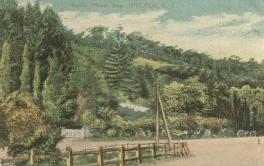 Bendigo Historical Society Inc.
Postcard - GLADYS DEAN COLLECTION: POSTCARD, 1906 - 1908
Printed coloured postcard depicting Devils Elbow Adelaide. Image is of a country road sharp bend set against a thickly treed hillside. A white gate, parts of a white fence, a horse and cart and another cart can be seen on the far edge of the road. A post and rail fence and power pole are in the foreground. The words Devils Elbow Near Adelaide S.A. are printed in red across the top edge. On the reverse card is addressed to Miss R Dean 'Esmond' Golden Square Victoria and a one penny stamp is affixed and postmarked Adelaide. Handwriting is on one side. The words South Australian Post Card Commonwealth of Australia are printed on the top.postcard -
 The Beechworth Burke Museum
Photograph, Circa 1858
Taken around 1858, depicting a row of five business buildings on a rocky, sloping hillside at New Town, with a view across to residences and open land. Businesses included, Joseph E. Bishop, Coach Builders; Straughair Duncan, Engineers, Blacksmiths & Farriers; Straughair Duncan, Beechworth Foundry; Wholesale & Retail Est. 1855, Mackenzie Family Store ; and T. Pratten, Grocer. Eleven men may be seen outside the Foundry building. The Mental Hospital can be seen in the background. Mark Straughair and John Duncan, established the Beechworth Foundry, Newtown in 1858 and went on to build an important industry, employing around sixteen men, after acquiring Alexander Roger's New Ford Street Foundry in the late 1860s. Making and repairing mostly mining and agricultural machinery for the Ovens District and a Beechworth brewery, the business continued to function after Straughair's death in 1882, up until the death of Duncan in 1896, when the business folded. This photograph is historically significant because it shows the development of the businesses in Beechworth from the early establishment of the town.Black and white rectangular photograph printed on photographic paperReverse: [Agfa wordmarks: diamond-shaped watermarks for Agfa photographic paper] 1997.2642/ refer to/ 1997 2650/ 3056joseph e. bishop, mark straughair, john duncan, mackenzie family store, beechworth foundry, coach, coach builder, engineer, blacksmith, farrier, t. pratten, beechworth grocers, grocer, new town, newtown beechworth, newtown, foundry, 1858, local business, new ford street foundry, alexander rogers, victorian agricultural history, mining machinery, beechworth brewery, ovens district, mayday hills mental asylum, beechworth mental hospital, beechworth mental asylum, mental hospital, mental -
 Southern Sherbrooke Historical Society Inc.
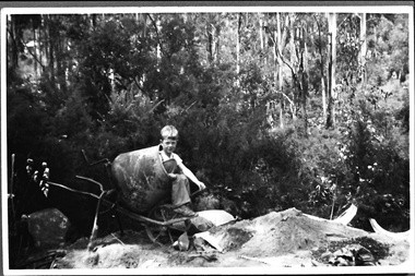
Photograph - Terry Smith at the building site of the caretaker's house, Belgrave Reservoir, c.1940s
Black and white photo of Terry Smith, Pam Harris's younger brother, aged about 6 or 7, during the building of a septic tank for the caretaker's house at Belgrave Lake Park. Terry is sitting in a concrete mixer. On the ground are bags of concrete. A pile of sand is on a tarpaulin. Behind Terry there are shrubs and small trees and behind them are tall trees on a steep hillside. The Belgrave Reservoir is at the bottom of the slope. A house can be seen in the distance, possibly the house visible in B0399. Terry and Pam's father, Oscar Smith, built the caretaker's house, selling it in 1960 for £1250. The photo probably dates to the 1940s and is part of a collection of family photos donated by Pam Harris, Shire of Sherbrooke President, 1982-1983 & 1987-1988. -
 Mt Dandenong & District Historical Society Inc.
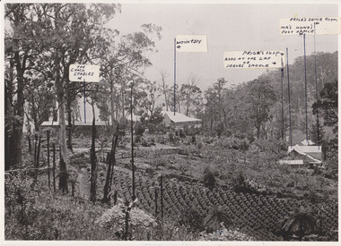
Photograph, 1908 View of the Kalorama Gap from Main Road With Labelling, 1908
Photograph with labels attached to front identifying buildings. View of the Kalorama Gap from main Road (now Ridge Road), looking across Walker's raspberry patch with Mountjoy coaching stables on the LHS and Mountjoy Guest House in centre. Price's house and shop on the RHS. This photograph has a detailed inscription on the back handwritten by John Lundy-Clarke in 1974.1908 View of the Kalorama Gap from main Road – now Ridge Road above Lot 2 of the Village Settlement. Looking across Walker’s raspberry patch with “Mountjoy” coaching stables on left. “Mountjoy” in centre. Prices house and shop on right with Hands “Beulah Tearooms” above Prices roof. On hillside beyond Hand’s is the slope now taken up by Kalorama Terrace. Walker’s well, then newly dug is in lower right hand corner below the tree fern head. Mt Kalorama is the hill top right. Track leaving Main Road left is Walker’s entrance drive.kalorama, kalorama gap, walker, beulah tea rooms, price, hand, mountjoy, mt kalorama