Showing 346 items
matching mt beauty construction
-
 Kiewa Valley Historical Society
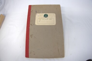
Book - Minute book of the Progress Association Ladies' Auxilary, Minute book of the Progress Association Ladies' Auxilary, 25th February 1960 to 29th February 1968
This is the 1st minute book for the Mount Beauty Progress Association Ladies Auxilary. The first meeting was held on 25th February 1960. At this time the construction of the Kiewa Hydro Electric Scheme was coming to a close and the town of Mount Beauty and its infrastructure was being handed over by the State Electricity Commission of Victoria (SECV) to the Bright Shire. Homes and businesses were sold and residents were having to 'fill in the gaps' for services that had been provided by the SECV.The Mount Beauty Progress Association was formed by community members to improve and enrich the lives of people in the early days of independence from the State Electricity Commission of Victoria as construction of the Kiewa Hydro Electric Scheme was coming to a close and the town and its infrastructure was being handed over to the Bright Shire.Foolscap Ritewell No. 246 Minute Book with red cloth spine and thick brownish cardboard cover. Label on front cover - Cream with "Ritewell (in green over logo) / No 246 Minute Book (printed in green)kiewa hydro electric scheme; bright shire; mount beauty progress association; fund raising. -
 Kiewa Valley Historical Society
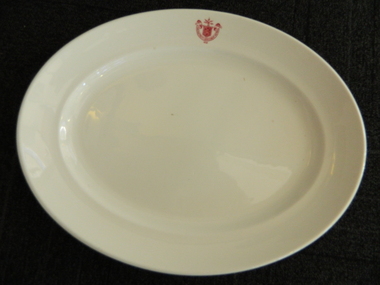
Plate - SECV dinner plates x2
The SECV had chalets, cafes, mess halls and tea rooms all over Victoria including their construction sites. The SECV had a stores system which purchased thousands of sets of crockery & cutlery for use by personnel. there was a system of chefs, cooks, tea persons etc. to supply food and beverages to the workers. 1921 signified the year the SECV was formed.This dinner plate was used at one of the sites on the Kiewa Hydro Electric Scheme which began construction in 1938 and concluded in 1961. Heavy white ceramic oval plate with State Electricity Commission of Victoria 1921 logo/insignia on the inside of one edge - middle of the long side of the plate. On the base, also inscribed in red are details of the makers.State Electricity Commission of Victoria / 1921. On the base: Vitrified / Sold by/ Cafe and Hotel Supplies / Pty. Ltd./ DunnBennett & Co. ITC / Burslem / Made in Englandstate electricity commission of victoria, dinner plate, crockery, kiewa hydro electric scheme, mess hall, mt beauty chalet -
 Kiewa Valley Historical Society
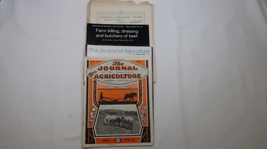
Journals - Department of Agriculture, 1. 1950s and 2. one 1932 & others 1970s
The Kiewa Valley has been a farming district from early settlement of white people. This has continued until the present although the nature of farming has varied over the years. Access to information has improved with transport and technology. The journals kept the farmers informed and up to date.These booklets and journals were one of the few sources of information during the 1950s for the isolated farmers of the Kiewa Valley. The Kiewa Hydro Electric Scheme improved both transport and technology during the scheme's construction from the 1940s. It provided the township of Mt Beauty at the upper end of the valley where shops and schools were constructed, roads were improved out of the valley and the supply of electricity for milking etc. became available. 1. 14 articles each bounded by 2 staples, and each reprinted from Dept. of Agriculture Journal on a particular topic relating to Agriculture. All black & white and c1950s. 2. 4 Journals with colored covers 3 from Victoria Dept. of Agriculture (1932, 1974 & 1975) and 1 from Sth. Australia.1. "J.H.Wallace" hand written top right corner of covers of pamphlets titled 'Diseases Affecting /Young Cattle' and 'Mastitis'. "AHW" hand written top right corner of cover of pamphlet titled ' Grading Land for Irrigation' 2. Nonefarming, agriculture, cattle, pasture, kiewa valley, department of agriculture in victoria, kiewa hydro electric scheme, -
 Kiewa Valley Historical Society
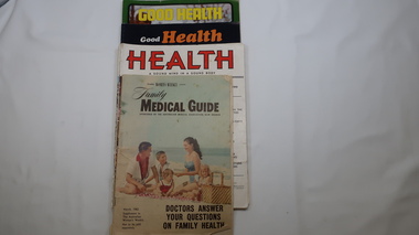
Magazines - Health, 1951, 1952, 1973, 1974, 1962
These magazines published articles on health for the family giving up to date information with diagrams on common health problems. Magazines with written Information was subscribed to by families at the time as transport and technology was not readily available in remote areas. The Upper Kiewa Valley situated in a remote part of Victoria didn't have easy access to health information. These magazines were available to farmers in the Kiewa Valley and to the workers and their families during the construction of the Kiewa Hydro Electric Scheme from the 1940s. With the introduction of improved transport and technology magazines eventually became less popular as a source of information. They are of interest in that they indicate the medical knowledge of the time and can thus be compared to current day knowledge.11 magazines with colorful covers and the occassional colored picture inside. Each has 32 pages. Periodicals - March, may, July, Sept, Nov. 1951 & jan. 1952. Also - Jan-Feb., Sept-Oct. 1973 and Mar, July-aug. 1974 Also Australian Women's Weekly supplement magazine 'Family Medical Guide' March 1962 with 47 pages. Inserted is a 16 page supplement (also Women's Weekly) dated Aug. 1976 titled 'Poison & First Aidhealth, magazines, medical guide, kiewa hydro electric scheme, kiewa valley -
 Kiewa Valley Historical Society
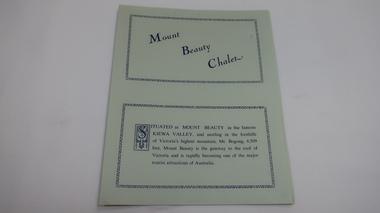
Leaflet - Mount Beauty Chalet, Mount Beauty Chalet, Pre 1966
... . These are the two main industries for the construction town of Mt Beauty ...The Mount Beauty Chalet was built by the State Electricity Commission as accommodation for single staff working on the Kiewa Hydro Electric Scheme. Towards the end of the completion of the Scheme the chalet was used for accommodating tourists. This brochure advertises the attractions in the area and includes tariffs - the Weekly rate and Casual rate.The chalet was built for accommodating employees working on the Kiewa Hydro Electric Scheme and then became a centre of accommodation for tourists in Mt Beauty. These are the two main industries for the construction town of Mt Beauty with the Chalet playing an important part.Pale green sheet of paper folded in half, with navy blue print. Advertising Mount Beauty Chalet under several headings. On the back the leaflet has been glued onto paper which, in turn, has been cut so as to not show around the outside.mt beauty chalet; tourism; state electricity commission of victoria; kiewa hydro electric scheme; accommodation -
 Kiewa Valley Historical Society
Booklet - Victoria's Hydro Power x2, Victoria's Hydro Power - SEC, August 1975
The State Electricity Commission of Victoria built several hydro power stations from 1928-1981. This book names each - up to 1975 - with a summary and explanation.The State Electricity Commission of Victoria built the Kiewa Hydro Electric Scheme which included the construction of Bogong Power Station, McKay Creek Power Station and West Kiewa Power Station. It also established infrastructure such as the townships of Bogong and Mt Beauty and the opportunity for tourism in the area Colored green/blue 'splash' of water on front cover with SEC logo in white centred under the yellow printed title. On the back cover is the SEC logo at the bottom in the middle.state electricity commission of victoria; kiewa hydro electric scheme; mckay creek power station; clover power station; west kiewa power station -
 Kiewa Valley Historical Society
Leaflet - Kiewa, Welcome to Kiewa
The State Electricity Commission of Victoria constructed the Kiewa Hydro Electric Scheme from 1938 to 1961. The Scheme included three power stations, dams, tunnels and was becoming a popular tourist destination with Falls Creek Ski field within its boundaries.This leaflet was published by the SECV to ensure all visitors to the Kiewa Hydro Electric Scheme were made aware of safety measures with regard to their driving and to bush fires. These were necessary as the area was unique with driving on mountainous roads, changeable and extreme weather and the threat of bush fires. The gatehouse existed during construction, when the SECV was in charge, as a restriction to entry to the Scheme for SECV workers and those with permission to enter. The SECV controlled the area so in case of accident, the SECV was the body to contact not eg. the police.Small white and green leaflet made from one sheet of glossy paper and folded in half. Front cover has the title in the middle, the SECV emblem at the centre top and across the bottom is a message to read the inside pages which are safety messages for driving and bush fires. The back cover has a RACV road map of Kiewa and its 'works' including the Gatehouse which was the entrance to the scheme.The map also has an insert of the main roads & nearby cities. state electricity commission of victoria; kiewa hydro electric scheme; gatehouse; safety rules; kiewa -
 Kiewa Valley Historical Society
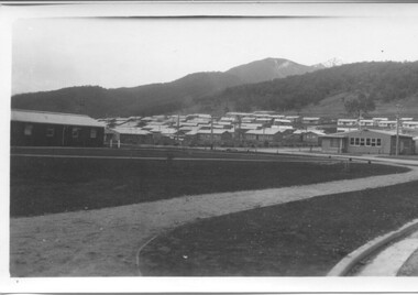
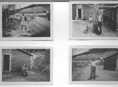
Photographs - Townships of Mt Beauty and Bogong and the Kiewa Valley, c 1940, 1950, 1960
The township of Mt. Beauty was built to provide family accommodation for personnel working on the construction of the Kiewa Scheme. construction commenced in 1946. Photo 1 is looking towards the corner of Lakeside Ave. and Kiewa Crescent. The Post Office is on the corner and the original building housing the Co op store was in Kiewa Crescent. Photo 2 is taken at a later date as the garden in front of the Post Office is well established. The Community Centre is centre left of the photo and the back buildings are the staff accommodation called "The Chalet". Photo 3. Farming country taken from Wallacedale. The Wallaces were one of he early farming families in the Kiewa Valley. Photo 4. This photo is of Junction Camp at Bogong Village and was commenced late in 1939 and by 1940 accommodated 96 men who were engaged in work on Junction Dam. Sleeping accommodation was provided in hutments, each of four rooms, each room being approx. 12 feet by 10 feet and provided for the accommodation of 2 men. This camp remained in use until November 1962.These photos have both historical and social significance. They show the type of accommodation available for workers during the construction of the SEC Kiewa Hydro Scheme as well as early streetscape views of Mt. Beauty. The Junction Camp photo also shows the state of the forest following the 1939 fires in the area.4 Black and white photographs of various sizes.Photo 1. On back, hand written in pencil: top left hand corner: "Sept 1950". Centre of photo: "Return to Gibson Envelope". Right hand side: "Cooper". Bottom left corner: "Mt. Beauty Camp SEC Kiewa Scheme". Photo 2. No inscriptions or markings. Photo 3. Back of photo handwritten in pencil: "In W>T> June 14. 1961 page31. Some of the farming country in the Kiewa Valley. This taken from the home of Mr. Geoff Wallace Wallacedale, Kergunyah where some of his 600 cattle were rounded up." Bottom right corner "Return to Gibson Envelope". There is a copyright stamp belonging to "the Herald & Weekly Times Ltd. also on the back. Photo 4. Typed on a sticker on the back of the photo "Stable attendants Cottage and Camp Sept. 1940".camp, sec kiewa scheme, kiewa, cattle, mt. beauty -
 Kiewa Valley Historical Society
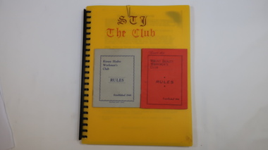
Folder - Mount Beauty Workmen's Club
The Mount Beauty Workmen's Club was established in 1946. Formerly known as the Kiewa Hydro Workmen's Club.Social history of Mount Beauty during the construction of the Hydro Scheme and its aftermath.Plastic spiral bound A4 folder with numerous plastic sleeves./ The folder contains club rules, some auditor's reports and financial statements and misc correspondence - mostly from 1990s./ Inside there are two rule booklets one red and one grey.On the top front cover of the red rules booklet is written 'Peart. A.L'.workmen's club, community club, west peak hotel, mt beauty, secv, kiewa hydro electric scheme -
 Kiewa Valley Historical Society
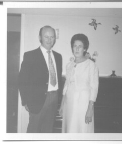
Photograph - Wedding Photographs x 2 - McKendrick, 11th January, 1958
Photographs of Ian and Margaret Rose McKendrick (nee Vyner) on their wedding day. Margaret was the daughter of Reta and Harry Vyner who were early residents of the Kiewa area during the construction of the Hydro Electric Scheme. Margaret and Ian were married at St. Mathews Anglican Church, Albury on 11th January 1958. The cream dress that Margaret wore was her Mother's dress, Reta Vyner. Note: Wedding Dress is stored in Box 66. Wedding Photo is in KVHS 0970(B) This wedding dress was part of a display in the Information Centre and is part of the social history of Mt. Beauty and Bogong Village during the construction period of the Kiewa Hydro Electric Scheme. It is typical of the apparel worn in the 1950's. Two photographs, one black and white and one sepia tone No inscriptions or markingswedding dress, clothing, mt. beauty, social history, mckendrick -
 Kiewa Valley Historical Society
Photograph - 8 Black and white photographs - SECV, Unknown
All eight photographs have been taken at a workmen's camp erected by the State Electricity Commission to house workmen during the construction of the Kiewa Hydro Electric Scheme. These were established in close proximity to various work centres - Junction Camp at Bogong Village, three camps at Mt. Beauty, West Kiewa, Clover Dam and Clover Flat, Howman's sawmill and Howman's Gap, Rocky Valley, Langford's Gap, Pretty Valley, Mountain Creek and Big Hill. These photos have not been identified as to which camp they are taken but typical of the type of accommodation for wages personnel. They followed a general design and layout. There was a mess and recreation hall as well as a building for general trading and postal facilities (this conducted by proprietors of trading stores in Mt. Beauty and Bogong). Originally the rooms accommodated 2 men but later there was a demand for single rooms - the floor size then being 10 feet x 8 feet and furnished with a bed, small table and chair and cupboard with hanging space. The first camps were erected in 1940 and the last was removed in 1962.These photographs are of historical significance as they show the type of accommodation provided for wages personnel working on the Hydro Electric Scheme between 1940 and 1960.Eight small black and white photographs of unknown person and workmen's camp.All photos have been stamped on the back - Two "965U" in red, four "S80 " in green (indistinct) and two "141" in red.workmen's camps, kiewa hydro electric scheme, accommodation, secv, camps on kiewa hydro electric scheme, west kiewa -
 Kiewa Valley Historical Society
9 small black and white Photographs, c1950
These photos were taken in 1950 by Bill Peel who was appointed as a secondary teacher at the newly built Mt. Beauty School in January 1950. He was the entire secondary staff for an enrolment of 4 students in Form 3 (year 9), 9 in Form 2 and 25 in Form 1. There were also 4 primary teachers as the school combined both primary and secondary education. He was provided with accommodation at the staff hostel (Mt. Beauty Chalet). A autobiography is also enclosed describing his 12 months as a teacher in Mt. Beauty.These photographs give a clear picture of the stage of construction of housing in both Bogong Village and Mt. Beauty in 1950. Large workmen's camps are clearly visible at both sites. Construction at Rocky Valley Dam site has just begun. They are of historical significance. The autobiography gives an excellent insight into conditions teachers faced in small country schools;Nine small black and white photographs3 photos stamped with "1 856", 4 photos stamped with "210, 2 photos are identified with hand written inscriptions, in ink, on the back - "Railway Bridge Bright '50" and second photo "Lake Catani '50" also 'Kodak' circular stamp on back of both.mt. beauty, bogong, acccommodation, education, rocky valley -
 Kiewa Valley Historical Society
Calendar 2008
Brief history of the SECV construction town of Bogong which became a tourist town."Memories of Bogong Calendar 2008" Photographs of the physical environment. Front cover has a photograph of a person standing in a river. A short history of 'Bogong 1957-1963' and 'Come visit Bogong Village' a 'celebration of Bogong Village's environment'. 12pp with a hole (to hang up) in the centre bottombogong, calendar, tourism, bogong village, secv, kiewa hydro electric scheme -
 Kiewa Valley Historical Society
Book - Kiewa Hydro Electric Scheme, Bogong - Technical Notes
Ronald G. Thorn was a cadet engineer with the SEC on the Kiewa Hydro Electric Scheme. The SEC employed young engineers as cadets to gain experience in their profession. As a cadet he took notes on his work for future reference. Refer to KVHS 1148Ronald George Thorn cadet engineer with the SECV on the KHES 1948 - 1950 doing overhead line re-construction and maintenance plus electrical design and drawing work.Leather cover with 2 silver rings. Pages A-Z with additional fold out pages of diagrams. Some pages have handwritten notes.Inside on front cover "R.G.Thorn / H.V. Section/ Yarraville Lab/ SEC / OE Section Y.T.S. R.T.S./ N.P.S. / Stamped 'Bogong" / N.P.S. / Sub/E / E.P.E."kiewa hydro electric scheme, r.g.thorn, cadet engineers, electrical design -
 Kiewa Valley Historical Society
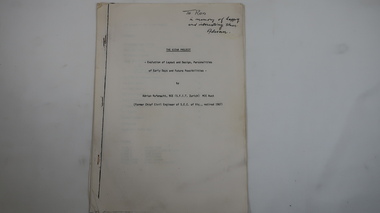
Memoir - Adrian Rufenacht, The Kiewa Project
Adrian Rufenacht, BCE (S.F.I.T. Zurich) MIE Aust. former Chief Civil Engineer of the State Electricity Commission of Victoria, retired 1967. Insight into the Kiewa Hydro Electric Scheme.First hand knowledge of the history of the Kewa Hydro Electric Scheme.40 pages stapled with 4 staples. The Kiewa Hydro Electric Scheme by Adrian Rufenacht, former civil engineer of SECV. Includes maps.On the front page - handwritten: 'To Ron / in memory of happy / and interesting times. / Adrianadrian rufenacht, khes, kiewa project, construction, secv -
 Kiewa Valley Historical Society
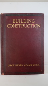
Book - Technical, Building Construction by Prof. Henry Adams M.I.C.E
Comprehensive technical detail for building in 1907. Materials and tools of the time.Belonged to a resident of the Kiewa Valley.A thick book with dark red hard cover and gold print for title and author. It has more than 567 pages of shiny thin paper. Its spine is bound and has the title, author and 'Cassell & Company/Limited' also printed in gold on it. Printed 1907Inside on the cover page "Charles Blacker / Murrumbeena / July 18 1908.building trade -
 Kiewa Valley Historical Society
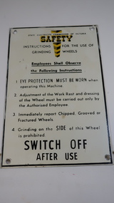
Sign - SECV, Safety - Grinding Wheels
... and included the construction of Mt Beauty and Bogong townships. Safety ...The State Electricity Commission of Victoria produced and displayed safety signs for their employees during the construction of the Kiewa Hydro Electric Scheme.KHES was constructed from the late 1940s to early 1960s and included the construction of Mt Beauty and Bogong townships. Safety was a concern for the SECV towards its workers. Metal black print on white background with yellow 'emphasis' at the top - 'Safety'. "Instructions for the use of / Grinding Wheels". There is a circular hole in each corner with a black frame around the perimeter.state electricity commission of victoria, kiewa hydro electric scheme, safety sign, grinding wheels -
 Kiewa Valley Historical Society
Book - Diary - G.P. Lyons SECV x4, 1. Catherine Moss; 2. Crossing the Rubicon; 3. Running the Line; 4. Twilight of the Gods
Geoff Lyons worked initially as a storeman for SECV on the Kiewa Hydro Electric Scheme and later possibly as a linesman on the transmission lines from Mt Beauty to Melbourne.A social history of working in the north east on a construction site. Geoff worked with European migrants in his youth and describes his life as a young man - an interesting comparison to life in the 2020s.4 Books with coloured (2 tones) cardboard cover with hard plastic attached. 1 and 2 books are bound by white plastic strips 3 and 4 are bound with white tape. 1. 1951-52 with 150 pages; 2. 1952-53 with 130 pages; 3. 1954-55 with 101 pages; 4. 1955-56 with 122 pages.All 4 books have "To Colin & Lyn Maxwell from Joy and Geoff Lyons" handwritten on the first page.geoff lyon, storeman, linesman, secv, khes -
 Kiewa Valley Historical Society
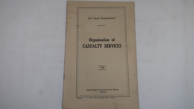
Book - Air Raid Precautions, 1941, Organisation of Casualty Services by State Emergency Council for Civil Defence Victoria
An Air Observers Hut was used by volunteers 24 / 7 at Bogong to monitor the skies for enemy aircraft during WWII. Bogong was built by the SECV during the construction of the Kiewa Hydro Electric Scheme. See also KVHS 0937 (photo), KVHS 0938 (certificate), KVHS 1259 (book)This book informed the volunteers of First Aid posts, ambulances, rescue teams etc.Cream coloured book with black print on cover. 31 pages printed on both sides and with some black & white photos. Bound by 2 staples.air raid, wwii, bogong air observers hut, khes -
 Kiewa Valley Historical Society
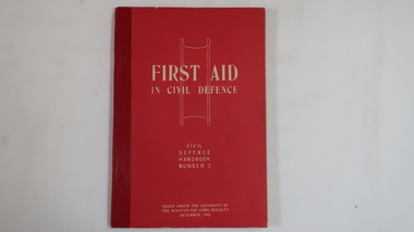
Book - Civil Defence, First Aid in Civil Defence - Handbook No.3 Dec. 1942
First Aid during WWII was important for the civil population in case of attack or accidents especially in remote communities. This book was issued under the authority of the Minister for Home Security Dec. 1942This book informed the workforce employed by the SECV working on the construction of the Kiewa Hydro Electric Scheme in the remote Kiewa Valley.Small thick red book with title and 'author' written in white block letters on the front cover. 160 pages with some diagrams and bound by red tape.first aid, wwii, civil defence, kiewa valley -
 Kiewa Valley Historical Society
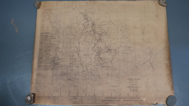
Map - Kiewa Scheme General Plan
Existing and possible future roads are numbered and named 1 - 45. The plan is based on an aerial photos taken March 1945. It includes revisions up to 1951. Signed by H.H.C. Williams, construction engineer. Mountains, rivers, roads and SECV places are named, also SECV infrastructure and construction eg. workers camps, Power stations.Significant for the information re the Kiewa Hydro Electric Scheme's development.Yellowed paper with brown print. Kiewa Scheme general plan showing its development. A lot of information is recorded. Note: Dyeline print was used which causes fading when exposed to light. Handwritten: 'Bob Duncan'bob duncan, kiewa hydro electric scheme, secv, khes development -
 Kiewa Valley Historical Society
Postcard Circa 1950, Snow Plough, Bogong High Plain,5,500 Feet Kiewa Hydro-Electric Project, Circa 1950
This postcard was produced in the 1950's for the tourist trade in the Kiewa Valley and Alpine region. It encompasses the period when the State of Victoria was pressured by the ever increasing demand by industry and its population for electricity supplies. Hydro electricity was seen as an untapped natural resource to quench this demand. The Victorian Alps and the rivers flowing into its valleys was ideal for the construction of the Kiewa Hydro Electricity Scheme. The late 1940's saw the development of this scheme and the changing of sections of alpine landscape is covered by this and other postcards/pictures (tourists, construction workers, and established rural populations). This period in time was before the established wildlife and forest/nature groups became political activist who changed legislative acts to protect the environment. This rural region (Kiewa Valley/alpine plains) was at most only significant to a smaller group of winter sports, summer hikers/horse riders and rural farmers/graziers. The numbers of tourists and the increase in the local resident population was boosted by the construction of the Hydro Electricity Scheme. This influx to the regional population resulted in a corresponding diversity in services and brought about an environment that responded to a growing level of tourists and thereby permitting this industry to grow more rapidly than it would have naturally. This postcard details an attraction to the "cleaner" method of providing electricity. This postcard was purchased in 1950 by a surveyor at Landford's Gap. This item is a black and white photograph(professional) of a panoramic view of a snow plough clearing the unsealed road in 1950.This postcard is on quality paper and the reproduction of the picture is of a high standard.For other "tourist" postcards see 0480 (A) -(F) for other photos of similar postcards. kiewa valley tourism, victorian alps, alternate energy supplies, alpine population growth, secv, snow plough -
 Kiewa Valley Historical Society
Postcard Circa 1950, Road to Bogong High Plains Kiewa Hydro Electric Project, Circa 1950's
This postcard was produced in the 1950's for the tourist trade in the Kiewa Valley and Alpine region. It encompasses the period when the State of Victoria was pressured by the ever increasing demand by industry and its population for electricity supplies. Hydro electricity was seen as an untapped natural resource to quench this demand. The Victorian Alps and the rivers flowing into its valleys was ideal for the construction of the Kiewa Hydro Electricity Scheme. The late 1940's saw the development of this scheme and the changing of sections of alpine landscape is covered by this and other postcards/pictures (tourists, construction workers, and established rural populations). This period in time was before the established wildlife and forest/nature groups became political activist who changed legislative acts to protect the environment.This rural region (Kiewa Valley/alpine plains) was at most only significant to a smaller group of winter sports, summer hikers/horse riders and rural farmers/graziers. The numbers of tourists and the increase in the local resident population was boosted by the construction of the Hydro Electricity Scheme. This influx to the regional population resulted in a corresponding diversity in services and brought about an environment that responded to a growing level of tourists and thereby permitting this industry to grow more rapidly than it would have naturally. This postcard details an attraction to the "cleaner" method of providing electricity. This postcard was purchased in 1950 by a surveyor at Landford's Gap.This black and white photograph on a Valentine's postcard is from a V2 Argus photograph.. It is on a 200g/m paper density photo side gloss. See 0480 (A) - (G) for other photos of similar postcards.In white lettering " ROAD TO BOGONG HIGH PLAINS KIEWA HYDRO-ELECTRIC PROJECT", V3secv, road making, victorian alps -
 Kiewa Valley Historical Society
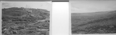
Postcard - Rocky Valley - Circa 1950, 1950
This postcard was produced in the 1950's for the tourist trade in the Kiewa Valley and Alpine region. It encompasses the period when the State of Victoria was pressured by the ever increasing demand by industry and its population for electricity supplies. Hydro electricity was seen as an untapped natural resource to quench this demand. The Victorian Alps and the rivers flowing into its valleys was ideal for the construction of the Kiewa Hydro Electricity Scheme. The late 1940's saw the development of this scheme and the changing of sections of alpine landscape is covered by this and other postcards/pictures (tourists, construction workers, and established rural populations). This period in time was before the established wildlife and forest/nature groups became political activist who changed legislative acts to protect the environment.This rural region (Kiewa Valley/alpine plains) was at most only significant to a smaller group of winter sports, summer hikers/horse riders and rural farmers/graziers. The numbers of tourists and the increase in the local resident population was boosted by the construction of the Hydro Electricity Scheme. This influx to the regional population resulted in a corresponding diversity in services and brought about an environment that responded to a growing level of tourists and thereby permitting this industry to grow more rapidly than it would have naturally. This postcard details an attraction to the "cleaner" method of providing electricity. This postcard was purchased in 1950 by a surveyor at Landford's Gap.This black and white photograph is from a Valentine's V2 Argus postcard. It is on a 200g/m paper density one side gloss. See also KVHS 0480 (A) to (L) for similar postcards. "ROCKY VALLEY FROM BOGONG HIGH PLAINS KIEWA HYDRO-ELECTRIC PROJECT" "V1"kiewa valley tourism, victorian alps, alternate energy supplies, alpine population growth, rocky valley, secv -
 Kiewa Valley Historical Society
Postcard - Junction Dam - Circa 1950, Circa 1950's
This postcard was produced in the 1950's for the tourist trade in the Kiewa Valley and Alpine region. It encompasses the period when the State of Victoria was pressured by the ever increasing demand by industry and its population for electricity supplies. Hydro electricity was seen as an untapped natural resource to quench this demand. The Victorian Alps and the rivers flowing into its valleys was ideal for the construction of the Kiewa Hydro Electricity Scheme. The late 1940's saw the development of this scheme and the changing of sections of alpine landscape is covered by this and other postcards/pictures (tourists, construction workers, and established rural populations). This period in time was before the established wildlife and forest/nature groups became political activist who changed legislative acts to protect the environment.This rural region (Kiewa Valley/alpine plains) was at most only significant to a smaller group of winter sports, summer hikers/horse riders and rural farmers/graziers. The numbers of tourists and the increase in the local resident population was boosted by the construction of the Hydro Electricity Scheme. This influx to the regional population resulted in a corresponding diversity in services and brought about an environment that responded to a growing level of tourists and thereby permitting this industry to grow more rapidly than it would have naturally. This postcard details an attraction to the "cleaner" method of providing electricity. This postcard was purchased in 1950 by a surveyor at Landford's Gap.This black and white photograph is a Valentine's postcard, from a V2 Argus photograph. It is on a 200g/m paper density with only the photo side gloss.Front "JUNCTION DAM & SPILLWAY, BOGONG KIEWA HYDRO-ELECTRIC PROJECT" on the flip side "VALENTINE'S POST CARD " "A GENUINE PHOTOGRAPH"kiewa valley tourism, victorian alps, alternate energy supplies, alpine population growth, junction dam, secv -
 Kiewa Valley Historical Society
Postcard - Junction Dam - Circa 1950, Circa 1950
This postcard was produced in the 1950's for the tourist trade in the Kiewa Valley and Alpine region. It encompasses the period when the State of Victoria was pressured by the ever increasing demand by industry and its population for electricity supplies. Hydro electricity was seen as an untapped natural resource to quench this demand. The Victorian Alps and the rivers flowing into its valleys was ideal for the construction of the Kiewa Hydro Electricity Scheme. The late 1940's saw the development of this scheme and the changing of sections of alpine landscape is covered by this and other postcards/pictures (tourists, construction workers, and established rural populations). This period in time was before the established wildlife and forest/nature groups became political activist who changed legislative acts to protect the environment.This rural region (Kiewa Valley/alpine plains) was at most only significant to a smaller group of winter sports, summer hikers/horse riders and rural farmers/graziers. The numbers of tourists and the increase in the local resident population was boosted by the construction of the Hydro Electricity Scheme. This influx to the regional population resulted in a corresponding diversity in services and brought about an environment that responded to a growing level of tourists and thereby permitting this industry to grow more rapidly than it would have naturally. This postcard details an attraction to the "cleaner" method of providing electricity. This postcard was purchased in 1950 by a surveyor at Landford's Gap.This black and white photograph on a Valentine's postcard is from a V2 Argus photograph. It is on a 200g/m paper density one side gloss only/. See 0480 (A) -(L) for other photos of similar postcards."JUNCTION DAM & SPILLWAY, LAKE GUY, BOGONG, KIEWA HYDRO-ELECTRIC PROJECT" "V5" on the flip side" VALENTINE'S POST CARD " "A GENUINE PHOTOGRAPH"kiewa valley tourism, victorian alps, alternate energy supplies, alpine population growth, junction dam, secv -
 Kiewa Valley Historical Society
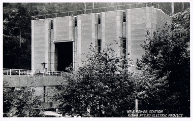
Postcard Circa 1950, No.3 Power Station Kiewa Hydro-electric Project "V.8", Circa 1950
This postcard was produced in the 1950's for the tourist trade in the Kiewa Valley and Alpine region. It encompasses the period when the State of Victoria was pressured by the ever increasing demand by industry and its population for electricity supplies. Hydro electricity was seen as an untapped natural resource to quench this demand. The Victorian Alps and the rivers flowing into its valleys was ideal for the construction of the Kiewa Hydro Electricity Scheme. The late 1940's saw the development of this scheme and the changing of sections of alpine landscape is covered by this and other postcards/pictures (tourists, construction workers, and established rural populations). This period in time was before the established wildlife and forest/nature groups became political activist who changed legislative acts to protect the environment.This rural region (Kiewa Valley/alpine plains) was at most only significant to a smaller group of winter sports, summer hikers/horse riders and rural farmers/graziers. The numbers of tourists and the increase in the local resident population was boosted by the construction of the Hydro Electricity Scheme. This influx to the regional population resulted in a corresponding diversity in services and brought about an environment that responded to a growing level of tourists and thereby permitting this industry to grow more rapidly than it would have naturally. This postcard details an attraction to the "cleaner" method of providing electricity. This postcard was purchased in 1950 by a surveyor at Landford's Gap.This black and white photograph from a Valentine's postcard is from a V2 Argus photograph postcard. It is on a 200g/m paper density photo side gloss. See 0480 (A) - (K) for other photos of similar postcards."No.3 POWER STATION KIEWA HYDRO ELECTRIC PROJECT" "V8"kiewa valley tourism, victorian alps, alternate energy supplies, alpine population growth, secv -
 Kiewa Valley Historical Society
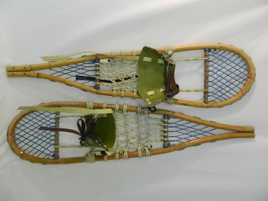
Snow Shoes
Snow shoes were used to move between places on the snow fields at Falls Creek and the Bogong High Plains especially during the construction of the Kiewa Hydro Scheme.Historical: Snow shoes were used on the Bogong High Plains during winter. The body is made of light wood 'bamboo' with a back and front wooden cross bar. Between the front cross bar and toe, blue nylon is tied to form diamonds 'lacing', similarly the back. Between the bars, in the middle is cream coloured rope tied to form a strong basket. A shoe harness made of olive green vinyl to which is clipped brown strong woven material tape with a circular steel loop through which the tape is threaded. There are 3 steel fasteners on 1 side and 2 on the other with a black plastic fastener. At the front between the cream and blue woven baskets there is a gap called the toe hole. The rope is attached either side of the toe hole to the front wooden bar.snow. falls creek. bogong high plains. transport. victorian alps. -
 Kiewa Valley Historical Society
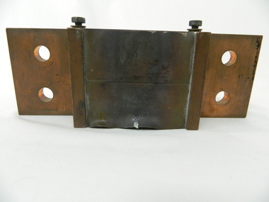
Electric Current Shunt
This shunt is a type of resistor built of copper and designed to carry a current. It was part of the Hydro generator control metering system. It reduces the large current to a small voltage.Historical: This equipment represents a major construction and ongoing operational industry dealing with the supply of hydro electricity to Victoria.Made of copper the shunt has a middle cube with 12 sheets of copper, 5mm apart formed like shelves. On either side of the cube are two shelves coming out from the middle. Both have 2 hollow circles 17.5mm in diameter 25 mm apart in the middle. At the Join of the 'shelves' and cube is a screw on each side.Screwed in metal plaque: Deriv. 1662691 / OHM 0.0000833 / AMP 1200 on the side of the cube above a shelf and on the opposite shelf: ALTO ----> (also a metal plaque screwed on). kiewa hydro electric scheme. secv. hydro generator. victorian electricity grid, power station. electricity., resistor -
 Kiewa Valley Historical Society
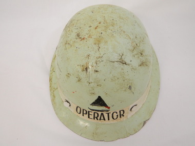
Helmet Safety
Safety helmets were worn during construction work on the Kiewa Hydro Electric Scheme and during its operation. Each group of workers had a different coloured helmet to identify their role.A pale green fibre glass oval shaped helmet with a small rim and with hard white plastic 'netting' inside - shaped with 6 pieces coming towards the outside from an oval in the centre. These are attached with screws. Around the circumference of the head is a plastic adjustable piece covered by soft plastic in the front. This has a wide cord attached that fits under the chin.On the outside front: a triangle colored in black with "operator" underneath. Inside rim at front: "Made in England"helmet. safety. kiewa hydro electric scheme. operator.