Showing 403 items
matching pictorial record
-
 Orbost & District Historical Society
black and white photograph, Green, O. S, late 19th - early 20th century
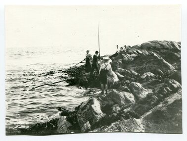
... of this photograph was possibly a glass plate negative. This is a pictorial ...Orbost locals have been fishing recreationally at Cape Conran since at least the early 20th century. The original of this photograph was possibly a glass plate negative.This is a pictorial record of family recreational activity in the late 19th to early 20th century.A black / white photograph of three people fishing off rocks into the ocean. Others are sitting on the rocks nearby.on back - " Cape Conran"recreation-fishing-cape-conran -
 Orbost & District Historical Society
black and white photograph, 1918
... ) This item is a pictorial record of roads in the early 20th century ...Tonghi Creek is 66km north - west of Orbost. Prior to the sealing of the Princes Highway west of Orbost, the road surface was anything but good, even by C1917 when cars started to use the road. From Orbost the old road via Marlo to Sydenham was abandoned for the new location which traversed more rugged country via Cabbage Tree, Bell Bird and Club Terrace to Cann River, and the reason for this diversion was on account of settlements being established at Murrungowar and Club Terrace, at which latter place there was a temporary rush to obtain gold. This road was constructed by the Public Works department and a maximum grade of 1 in 19 was adopted, and as speed was not to be catered for the grade followed in and out round the spurs and gullies, resulting in a maze of turns and twists which required a good deal of skill on the part of the horse driver to negotiate." - Bairnsdale Advertiser, Friday, May 2, 1947. (More information from Newsletter February 2010)This item is a pictorial record of roads in the early 20th century in East Gippsland.A large black / white photograph of a bridge over a small creek, surrounded by bush. The photograph is mounted on a thick cream coloured card.on back - "Bridge at Tonghi Creek 1918"tonghi-creek-bridge country-roads-east-gippsland -
 Orbost & District Historical Society
black and white photographs, 1915
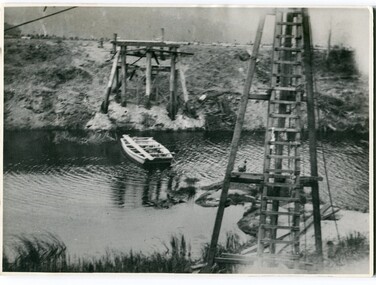
... at the right / Gordon " This is a pictorial record associated ...This photograph is of the construction of the first road bridge over the Genoa River - 1915. Before today's timber truss and concrete bridge was constructed between 1926-1928 by contractor J.T. Noble Anderson, two earlier bridges crossed the Genoa River at this location. They provided crucial links in the Princes Highway route from Melbourne to Sydney. The letter on the back of the postcard was written by Gordon ? to Alex ? on 2nd October 1917. "this represents the opening of Genoa Bridge. Mrs Alexander cutting the ribbon and Mr Martin holding it at the other side. Did most of the speaking. The gent holding the roll of paper is who came to open the bridge. I can't think of his name. Hubert is standing up at the right / Gordon " This is a pictorial record associated with the history of Genoa in East Gippsland.1100 -A large black / white photograph on a cream coloured buff card. It is of an unfinished bridge with men working there. A small rowboat can be seen on the far side of the river. 1100.1 - A photograph / postcard of the opening of "Genoa Bridge 1917". There is a ribbon stretched across the timber decking road in front of a group of people. 1100.2 - A black / white photograph of a road bridge across a river.on back - "Princes Highway - the 1st bridge over the Genoa River - 1915" on back of 1100.1 is a hand-written letter.genoa-bridge princes-highway-east-gippsland -
 Orbost & District Historical Society
black and white photograph, first half 20th century
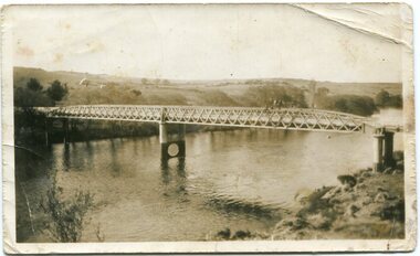
... . This is a pictorial record of a significant structure on the Snowy River ...This is the Dalgety bridge across the Snowy River. It is a steel construction.The first bridge over the river was constructed in 1888. There was a punt across the river before the bridge was built . Dalgety is a small service centre, located on the Snowy River approximately 235 km from Orbost. It was an early consideration for the site of Australia,s capital city. The Dalgety Bridge over the Snowy River has been an important item of infrastructure in the history of New South Wales for over 110 years. It was designed by noted bridge engineer J. A. McDonald,and was a technically sophisticated bridge structure for its time. This is a pictorial record of a significant structure on the Snowy River.A small black / white photograph of a large bridge over a river.bridge-dalgety-snowy-river -
 Orbost & District Historical Society
black and white photograph, Vogt, Stanley, first half 20th century
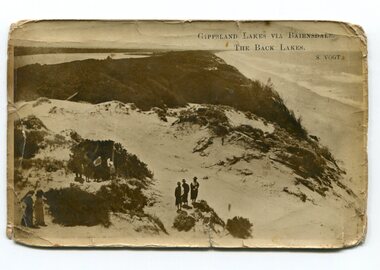
... . This is a pictorial record of the Gippsland Lakes in the early 20th century ...Back Lake track is near Metung, East Gippsland.This is a pictorial record of the Gippsland Lakes in the early 20th century.A black / white postcard photograph of a beach scene. Small groups of people are standing on a vegetated sand dune overlooking the water. on front - " Gippsland Lakes via Bairnsdale - the Back Lakes, S. Vogt"gippsland-lakes back-lake-bairnsdale -
 Orbost & District Historical Society
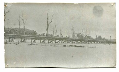
black and white photographs, Howard D. Bulmer, first half 20th century
... used by road traffic. This is a pictorial record of an early ...This bridge was built in the 1920s as a road and rail bridge, and was partly washed away by flood waters in 1934. After the end of the first World War the Victorian Railways considered an extension of the railhead across the river at Orbost, and in 1922 a new timber and steel girder structure, a joint Country Roads Board — Victorian Railways venture, was built and completed at a cost of £41,000 (the steel girders came from the Flinders Street viaduct reconstruction). Subsequently it was decided not to take the railway across the river, and the bridge has only been used by road traffic. This is a pictorial record of an early bridge across the Snowy River at Orbost.A large black / white photograph of the Orbost Snowy River bridge. There is a large copy as well as a postcard copy in sepia.on front - Snowy River Bridge Orbost H.D. Bulmer - photo - Lake Tyers.snowy-river-bridge-orbost -
 Orbost & District Historical Society
black and white photograph, January 1934
... . This is a pictorial record of a significant event in Orbost's history. orbost ...Orbost has been subject to major floods throughout its history, such as those which left the town isolated in 1934, 1952, 1971 and 1978. It is recorded that the Snowy River broke its banks and flooded the flats 104 times between 1884 and 1978. Extensive flooding in Eastern Victoria during June 1978, caused widespread damage to roads, road closures and hazards to traffic, particularly over the Queen's Birthday holiday weekend.This is a pictorial record of a significant event in Orbost's history.A very faded black / white photograph of flood water under the railway viaduct at watt's Gulch.orbost-flood-1934 railway-viaduct-orbost -
 Orbost & District Historical Society
black and white photograph, July 1922
... . This is a pictorial record of a significant event in Orbost's history. snowy ...A new bridge over the Snowy River at Orbost was opened for traffic on June 20th 1922. It was designed for future joint use by road and railway traffic, but it was only used for road traffic. During the last few years the condition of an old suspension bridge [the 1893 bridge] which was the only vehicular crossing between the town of Orbost and the railway station, caused much concern. The structure was of timber, except for the wire suspension cables of its central span of about 100 feet. A design was prepared in 1914 for a permanent bridge with five spans of 85 feet composed of plate girders on concrete piers. With great increase in the price of steel work during the war, the cost of this design became prohibitive, and the need for a new structure becoming urgent, alternative proposals were investigated. As a result the present design was adopted as providing a sem-permanent bridge at moderate cost. The new bridge spans the river about 160 feet upstream from the old bridge on a slight skew, the piers being at an angle of 80 degrees with the centre line of the bridge. It has a camber of about 2 feet 5 inches in its total length of 527 feet. ( information from Newsletter March 2014 - Lois Crisp) The photograph shows Mrs James Cameron cutting the ribbon at the opening of the Orbost Pile Bridge in 1922. This second bridge, was built by the Victorian Railways and the Country Roads Board. Constructed at a cost of 35,000 pounds and used second-hand girders from the Flinders Street- Spencer Street viaduct. On July 4 1922 it was officially opened by Mrs James Cameron. Unfortunately, her husband, who had long championed the building of the bridge so that it would be ready for the railway to continue to the border, was too ill to attend the ceremony. In fact, James Cameron died on July 13 after a long and severe illness (ref. S.R.M. 20.7.1922). There is a section of this ribbon in the collection - Registration No. 366. This is a pictorial record of a significant event in Orbost's history.A black / white photograph of a pile bridge with a suspension bridge behind it. There are many people standing on the bridge.on back - "Opening of Pile Bridge - 1922"snowy-river-bridge ceremonies cameron-mrs -
 Orbost & District Historical Society
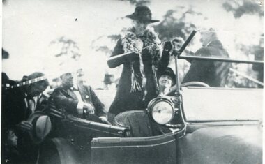
black and white photograph, July 1922
... . This item is a pictorial record of a significant event in Orbost's ...The photograph shows Mrs James Cameron cutting the ribbon at the opening of the Orbost Pile Bridge in 1922. The first bridge was officially opened in August, 1893 (ref. S.R.M. 12.8.1893) by Mrs W. Watt, the mother of Councillor Watt, who presided over the opening of the 1922 bridge. This bridge was extensively damaged when a herd of cattle allegedly stampeded over it causing the cable to snap. Even after repairs it became obvious that a new bridge was needed. This second bridge, was built by the Victorian Railways and the Country Roads Board. Constructed at a cost of 35,000 pounds and used second-hand girders from the Flinders Street- Spencer Street viaduct. On July 4 1922 it was officially opened by Mrs James Cameron. Unfortunately, her husband, who had long championed the building of the bridge so that it would be ready for the railway to continue to the border, was too ill to attend the ceremony. In fact, James Cameron died on July 13 after a long and severe illness (ref. S.R.M. 20.7.1922). There is a section of this ribbon in the collection - Registration No. 366.This item is a pictorial record of a significant event in Orbost's history.A black / white photograph of a lady standing up in a motor vehicle cutting a ceremonial ribbonsnowy-river-bridge-orbost cameron-mrs ceremonies -
 Orbost & District Historical Society
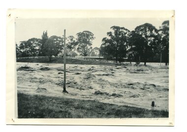
black / white photograph, January 1934
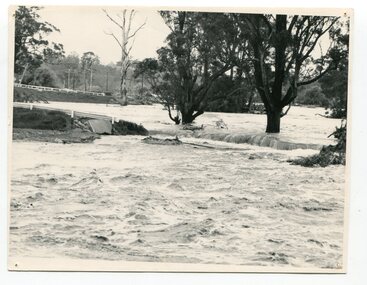
... . This item is a pictorial record of the 1934 floods, a significant ...Damage estimated at £500,000 was caused by the 1934 floods in the Orbost district. This 1934 flood was devastating, destroying a section of the 1922 Orbost bridge, wrecking fences, bridges and roads, dumping silt and debris on the rich river flats and drowning cattle. This photograph shows Lochiel Lagoon ( the billabong) in the foreground. Ten minutes after this photograph was taken, the centre span of the Orbost Bridge was washed away.This item is a pictorial record of the 1934 floods, a significant part of Orbost's history.A black / white photograph of swirling floodwaters with township in the background.orbost-floods-1934 natural-disasters-floods -
 Orbost & District Historical Society
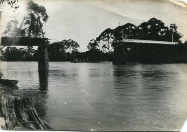
black and white photograph, January 1934
... away. This item is a pictorial record of the 1934 floods ...Damage estimated at £500,000 was caused by the 1934 floods in the Orbost district. This 1934 flood was devastating, destroying a section of the 1922 Orbost bridge, wrecking fences, bridges and roads, dumping silt and debris on the rich river flats and drowning cattle. The centre span of the Orbost Bridge was washed away. This item is a pictorial record of the 1934 floods, a significant part of Orbost's history.A black / white photograph showing the flood damage to the Snowy River Bridge. There is a gap in the bridge where the centre span has been washed away. In the background is a punt.orbost-floods-1934 natural-disasters-floods snowy-river-bridge -
 Orbost & District Historical Society
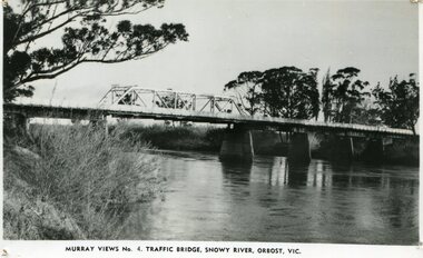
black and white photograph, Murray Studio, Murray Views, 1934
... production. This is a pictorial record of an early bridge across ...After the flood damage of 1934, the bridge was repaired with a new section in the middle. This bridge remained largely unchanged until its final demolition in 1975 after construction of the new concrete bridge and Orbost by-pass which exists today. This photograph is one of a collection of photographs produced by Murray Views, Gympie. It features eight scenic b/w photographic prints of Orbost and surrounding tourist areas.Photographs like these allowed tourists to send many images of their holiday destination or hometown in the one small package. Fred Murray opened Murray Studios in Gympie in 1906. The postcard and souvenir production side of the business initially covered Gympie and surrounding regions, but Murray expanded the business to include North Queensland, New South Wales and even Adelaide. It was opened under a separate name, Murray Views, in 1929. In 1945 the business was taken over by Murray’s nephews who began postcard folder production. This is a pictorial record of an early bridge across the Snowy River at Orbost.A black / white photograph / postcard of the Snowy River Bridge at Orbost.on front bottom printed - Murray Views No.4 Traffic Bridge , Snowy River, Orbost, Vic.orbost-snowy-river-bridge -
 Orbost & District Historical Society
black and white photograph, February, 1971
... Phillips. (see orbosthistory.com.au) This is a pictorial record ...This photograph shows the floodwaters during the 1971 flood at Orbost. The two mahogany trees in the photograph stopped the Snowy River from changing its course. The 1971 flood was the the worst flood on record. At Jarrahmond it was at least 11 metres and up to one and a half kilometres wide on the flats causing enormous damage to the flood plain. Records say that "The brown floodwater stain in Bass Strait could be seen from passing airliners." Considerable damage was done to railway infrastructure, roads and farms. More information from the APRIL, 2008 newsletter by John Phillips. (see orbosthistory.com.au)This is a pictorial record of a significant event in the history of floods in Orbost.A black / white photograph of raging floodwaters at the bottom of the Orbost township.orbost-flood-1971 -
 Orbost & District Historical Society
black and white photograph, 1976
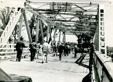
... . This is a pictorial record of the former Snowy River Bridge at Orbost. snowy ...This bridge over the Snowy River was opened on July 4 1922. It was constructed in 1922 alongside the previous suspension bridge. Its building was a combined effort of the Victorian Railways and the Country Roads Board at a cost of 35,000 pounds. It was replaced in 1976 by the present bridge after several major floods. This photograph shows people walking over the bridge for the last time.This is a pictorial record of the former Snowy River Bridge at Orbost.A black / white photograph showing a group of people walking across a bridge. There are several cars, a man on a horse and people standing on the side of the roadway.on back - "1976 - old bridge"snowy-river-bridge-1976 -
 Orbost & District Historical Society
black and white photograph, 1971
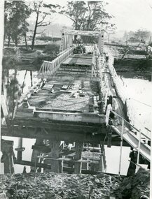
... Newletter 54N by John Phillips) This is a pictorial record ...This photograph shows the second major bridge across the Snowy River at Orbost. The current Snowy River bridge is the fourth to provide a crossing to the township of Orbost. The first, in 1891, lasted just two years before it succumbed to flood waters. The bridge in this photograph was built in the 1920s as a road and rail bridge, and was again partly washed away by flood waters in 1934. After the end of the first World War the Victorian Railways considered an extension of the railhead across the river at Orbost, and in 1922 a new timber and steel girder structure, a joint Country Roads Board — Victorian Railways venture, was built and completed at a cost of £41,000 (the steel girders came from the Flinders Street viaduct reconstruction). Subsequently it was decided not to take the railway across the river, and the bridge was only used by road traffic. It was severely battered by floods during its life. and after the devastating 1971 floods was eventually replaced by the current bridge in 1975. (info from Newletter 54N by John Phillips)This is a pictorial record of the flood damage in 1971 when part of the Snowy River Bridge was washed away.A black / white photograph of a bridge which has been damaged by floodwaters. It shows one end has been washed away.orbost-snowy-river-bridge-1971 floods-orbost-1971 -
 Orbost & District Historical Society
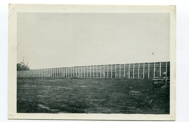
black and white photograph, Vogt, Stanley, 1918
... disappeared and this photograph is a pictorial record ...Maize,has been grown on the Orbost flats for at least 70 years. When early settlers began to arrive on the Snowy River somewhere in the 1880s, the land was mostly swamps and heavily timbered jungle on the river frontages. The swamps were drained, bit by bit, by men with short handled shovels and working in mud and water. The frontages were cleared by axe and shovel and fire. Several kinds of crops were experimented with such as hops, hemp and maize, the latter grew particularly well and became the main crop of district. The problem then was to thresh and deliver the product to the market. A small single cob machine was brought here and one man turned the handle, while the boy or Mum fed the cobs singly into the machine. A good day’s work would thresh about 50 bushels or about 12 bags (4 bushels). The task then was to cart the maize to market. For a few years this was done by horses and dray carrying about 60 bushels to Mossiface, where it was loaded onto river boats to Lakes Entrance, and then by ocean boats to Melbourne. Later it was taken to Bairnsdale by foot and loaded onto the trains to Melbourne. (more information in Newsletter October 2006) This crib, measuring seven chains, sixteen feet, contained 10,000 bags of maize cobs which were grown by Linc Timmons on Peter Irvine's farm (Fairlea?) in Orbost, East Gippsland. The growing of maize in the Orbost district contributed significantly to the economy of the township for many years, The many maize cribs once seen on the surrounding farms have now disappeared and this photograph is a pictorial record of that significance.A black / white photograph of a large maize crib full of maize in a paddock. There is a large framed copy of the original.agriculture-orbost farming-maize-orbost maize-crib-orbost -
 Orbost & District Historical Society
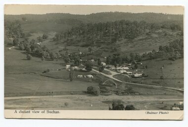
black and white photograph, Howard D. Bulmer, first half 20th century
... gippsland This is a pictorial record of Buchan in the first half ...This is a pictorial record of Buchan in the first half of the 20th century.A black / white photograph / postcard of a township in a valley. The photograph has been taken from a distance.on front - A Distant View of Buchanbuchan -
 Orbost & District Historical Society
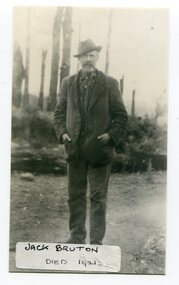
black and white photograph, before 1921
... of the Snowy River just to the south of town. This is a pictorial ...Jack Bruton selected land at Murrungowar and held the licence for the Murrungowar Hotel. He later became a butcher in Orbost. He was on the first Orbost Golf Club committee in 1906. .The golf club was established in 1906 it was originally formed as the Snowy River Golf Club and played on private land near the banks of the Snowy River just to the south of town.This is a pictorial record of Jack Bruton, one of the early settlers of Murrungowar, a former township east of Orbost.A black / white photograph of a man standing outside alone with his hands in his pocket. He has a moustache and has a pipe in his mouth. He is wearing a hat.on front - "Jack Bruton died 1921" on back - "Mr Jack Bruton, Murrungower Hotel"bruton-jack murrungowar-hotel orbost-golf-club -
 Orbost & District Historical Society
black and white photograph, 1919
... Coad on 4th December 1947. This is a pictorial record ...Ian and Jean McDonald are the children of Mr and Mrs Norman McDonald of 42 Gladstone Street, Orbost. This photograph was taken in late January 1919 on the occasion of Jean's first day of school at the house of John Rowe, a former headmaster, who then lived opposite the school. Norman Alexander McDonald was a book-keeper at Macarthur‟s and was very musical. He was proprietor of the Capitol Cafe, Nicholson Street, Orbost, selling the business to Mr Coad on 4th December 1947.This is a pictorial record of a significant event in the life of the McDonald family of early Orbost.A black / white photograph of two children, holding their hats , standing in front of a tree outside a school fence. on back - "Ian & Jean McDonald opposite the school"mcdonald-ian mcdonald-jean orbost-education rowe-john -
 Orbost & District Historical Society
black and white photograph, first half 20th century
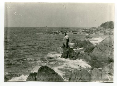
... is a pictorial record of that recreational activity in the early 20th ...This is a photograph of a man fishing off the rocks at Cape Conran in Far East Gippsland.Cape Conran has always been a popular fishing destination for Orbost people. This photograph is a pictorial record of that recreational activity in the early 20th century. A black / white photograph of a man fishing from rocks into the ocean. -
 Orbost & District Historical Society
black and white photograph, C1929
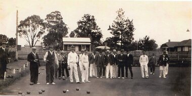
... recreation needs. This is a pictorial record of this recreational ...The Orbost Bowling Club was founded in 1929, by a group of farmers and businessmen. They set about providing a sporting icon for the town. Six rinks were constructed on the current site using horse drawn scoops and drags. The "Back to Orbost” 1937 book, describes the greens as "a bit rough for the first two seasons but now compare favourably with most country greens". Funds for the construction were raised by the issue of debentures at £5 each, and subscriptions were £1/1s/0d ($2.10). ( info. Margaret Smith) Included in the photograph are: Wm Kerr; D. Robinson; Lance Herbert; Fred McCoy; Jacob Perry; Ted Eaton; Jack McKeown; Wm Cumming; Harry Cameron; Dick Pardew; Wm Cowell; John Bird; Paul Spadaro; Carl Dreverman.Lawn bowling” is an outdoor game that has been popular for centuries. Bowling clubs play a significant role in community recreation needs. This is a pictorial record of this recreational activity in the first half of the 20th century.A black / white photograph of a large group of men playing bowls on a bowling green. Some are dressed in whites and others in suits.orbost-bowling-club sport recreation lawn-bowls -
 Orbost & District Historical Society
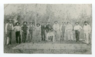
black and white photograph, April 18 1897
... Camp - April 18 1897. This is a pictorial record of a late 19th ...This photograph shows a group of surveyors at Treasury Camp - April 18 1897.This is a pictorial record of a late 19th century bush camp set up by surveyors involved in determining land settlement in East Gippsland.A black / white photograph of a group of men and a horse standing around a campfire. The camp is in a clearing and tents are set up with some bark coverings.surveyors- land-settlement -
 Orbost & District Historical Society
black and white photograph, 1895 - 1905
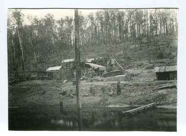
... February 2011 - John Phillips) This is a pictorial record of gold ...This photograph shows the Battery Goldmine at Club Terrace from 1896 - 1905. Gold was found at Club Terrace in 1896. One of the best finds at Club Terrace was the 'Ace of Clubs' mine which was later sold to the Mallina Gold Mining Company. Syd Cadwallader was appointed manager of the company. The gold was smelted and brought to Orbost on horseback. The only protection against thieves was a revolver and riding crop, which the manager always carried. The 'Ace of Clubs' was eventually closed as the company was unable to cope with the rising water problem. (information Newsletter February 2011 - John Phillips)This is a pictorial record of gold mining in East Gippsland during the late 19th - early 20th century.A black / white photograph of a mine site with timber mine constructions spread around. There is a river in the foreground. Some wooden buildings can be seen in the background.gold-mining-battery-mine club-terrace -
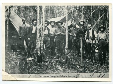 Orbost & District Historical Society
black and white photograph, 1897
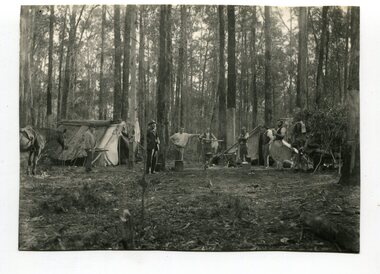
... mandatory in Australia. This is a pictorial record of a surveyors ...This is a surveyors' camp in the McCulloch Ranges April, 1897. Surveyors were among the first European settlers to arrive in Australia. A Surveyor-General was present on the First Fleet, as well as the first two ships which landed in South Australia. These men were issued with instructions to record observations in a journal that included the country’s general appearance, its soil, flora and fauna and the customs and language of local inhabitants. The conditions they worked in were harsh and they embarked on journeys with drays carrying cumbersome surveying and camping equipment, spending months camping out in the bush and mapping the land. It was not until well into the second half of the nineteenth century that the professional training of surveyors became mandatory in Australia. This is a pictorial record of a surveyors' camp in the late 19th century.A black / white photograph of a group of men standing at a campsite in the bush. Two tents are in the background.on the front - "Surveyors Camp, McCulloch Ranges" Some names have been added for identification - Bates, Thorn and others which cannot be read.surveyors-camp-mcculloch-ranges land-settlement -
 Flagstaff Hill Maritime Museum and Village
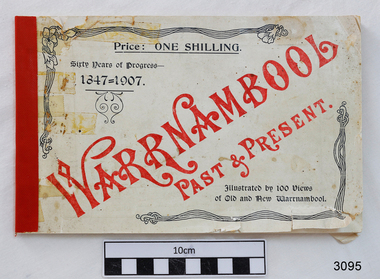
Book, Warrnambool Past & Present, 1907
This is the original book “Warrnambool Past & Present Sixty Years of Progress 1847-1907” that was published in 1907. It features photos of Warrnambool, taken by Edward Vidler in 1907, who matches them with some earlier prints. Vidler had a photographic studio in Liebig Street Warrnambool. Compiled by Edward A. Vidler, Secretary, Warrnambool Chamber of Commerce and Manufacturers, and Warrnambool and District Progress League The front cover of this little but significant book of photographs, advertisements and commentary reads “Warrnambool Past & Present. Sixty Years of Progress – 1847-1907. Illustrated by 100 views of Old and New Warrnambool. Price : One Shilling.” The title page of the book states “Warrnambool : Past and Present. The Metropolis of the Western District. Compiled from contemporary records by Edward A. Vidler, Secretary, Warrnambool Chamber of Commerce and Manufacturers, and Warrnambool and District Progress League. Illustrated. Printed by The Thompson Printing Co., Koroit Street Warrnambool.” In 1984 a facsimile reproduction of Vidler's publication was printed by the 'Osburne Group'. (The Group was named after Richard Osburne who owned the first newspaper in Warrnambool, called The Examiner. The donor of this book was another member of the three people who formed the Osburne Group). This newer book is an A4 portrait style format with Vidler's publication on the top of each page, and a matching 1984 photograph with contemporary comments on the lower half of the page. This book is significant record of the development and changes of Warrnambool therough the years since it was first settled to more recent times.Warrnambool Past & Present. Compiled by Edward D. Vidler. Sixty Years of Progress 1847-1907. Cream, soft cover, A5 landscape orientation, black and white print book, apart from front cover's title, which is red print. Printed by The Thompson Printing Co. Koroit Street, Warrnambool. Original 1907 publication. Includes photographs, advertisements and commentary on Warrnambool and the Western District of Victoria. Price was One Shilling. flagstaff hill, warrnambool, shipwrecked coast, flagstaff hill maritime museum, maritime museum, shipwreck coast, flagstaff hill maritime village, great ocean road, warrnambool history book, vidler’s warrnambool past & present, warrnambool historical photographs, edward a. vidler, pictorial work of warrnambool -
 Orbost & District Historical Society
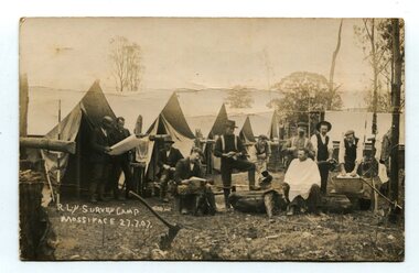
black and white photograph, July 27 1907
... . This is a pictorial record of a surveyors' camp in the early 20th century ...This is a camp of survey workers surveying the railway line . They were camped at Mossiface in 1907. It has been sent as a postcard - "Dear Miss Ross, Just a card, hoping you are well etc, trust you have not forgotten our trip. I forgot to get the name of the street in Hobart of Mr Benjamin or Temple?????? Sufficient. Yours sincerely H.R. Gordon". It has been dated September 30th 1907. There had been men surveying in East Gippsland from the late 19th century. Railway surveyors advocated two lines beyond Bairnsdale – one via Bruthen and the Tambo Valley to Omeo, the other via Swan Reach and Colquhoun to Orbost, then on to Bendoc and the border. With all the argument and feuding between the warring factions, by the end of 1891, the Parliamentary Railways Standing Committee gave up in despair of trying to reach any agreement and abandoned the idea altogether. Finally, with all problems solved, the first sod was turned at Mossiface on 9.1.1912, the government sticking to the original route in the 1890 survey .This is a pictorial record of a surveyors' camp in the early 20th century. The Bairnsdale to Orbost Railway was a significant contributor to the economy of Orbost until it closed.A black / white photograph / postcard of a group of men at a campsite. In the background is a row of tents. on the right side is a clothes line with several sheets hung over it. Two men are studying a map or chart; one man is sitting with a cloth around his shoulders while another is standing behind him cutting his hair; one man is washing cloth in a tin tub; another appears to be stirring a pot; others are sitting reading or just observing.on front - handwritten is " R.L.Y.S. SURVEY CAMP MOSSIFACE 27.7.07" on back is a letter - "Dear Miss Ross.............yours sincerely ????? Gordon"surveying-railway east-gippsland-railway mossiface-survey-camp -
 Orbost & District Historical Society
black and white photograph, C 1880
... than 200 years. This photograph is a pictorial record ...This photograph shows Orbost's first cricket team in the Lochiel paddock - C 1880's.Included are: Alec Cameron; Harry Richardson; Jo Swallow; Matt Lynch; Joe Roderick; ? Hatton; Alf Richardson; Janes Cameron; John Cameron;John FarquharSport is often regarded as an important part of life in rural Australia. Cricket is one of the most popular sports in Australia at international, domestic and local levels. It has been played in Australia for more than 200 years. This photograph is a pictorial record of an Orbost cricket team in the nineteenth century.A black / white photograph of a group of men standing in front of a cricket pitch. Two men are holding cricket bats and are wearing pads. One man is crouching.sport-cricket recreation-cricket -
 Orbost & District Historical Society
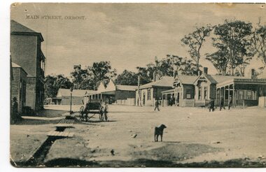
black and white photograph, early 20th century
... and in particular, the Orbost Post Office. This is a pictorial record ...This photograph shows the main street of Orbost and in particular, the Orbost Post Office.This is a pictorial record of the Main street of Orbost in the early 20century.A black / white photograph which has been taken diagonally across the post office in the main street of Orbost. Buildings are wooden. The road is unsealed. There are several people outside the building, a dog in the foreground and a small cart on the left side.at top front - MAIN STREET, ORBOSTorbost nicholson-street-orbost post-office-orbost main-street-orbost -
 Orbost & District Historical Society
black and white photograph, 1897
... in 1897. This is a pictorial record of the Orbost township ...This photograph has been taken looking up McLeod Street, Orbost from the present farmers' store towards the Club Hotel in 1897.This is a pictorial record of the Orbost township in the late 19th century.A black / white photograph of a street scene. The road is unsealed and there are several wooden buildings. A man can be seen on the left side.orbost-township mcleod-street-orbost -
 Orbost & District Historical Society
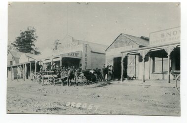
black and white photograph, August 1897
... net door in August 1897. This is a pictorial record ...This photograph shows Nicholson Street, Orbost with horse teams in front Of Borland's Blacksmith shop and Royce's Bakery net door in August 1897.This is a pictorial record of the main street of Orbost in the late 19th century.A black / white photograph of the main street of Orbost. The road is unsealed. There are several wooden buildings facing the road and a cart with a team of horses is standing outside the blacksmith's building. A small child is standing behind the cart and several men are outside the bakery.on front - Orbostnicholson-street-orbost orbost-township borlands-blacksmith royces-bakery main-street-orbost