Showing 487 items matching "renovated building"
-
 Bendigo Military Museum
Furniture - TABLES, MEETING ROOM BDRSL, Red Dog Furniture, Post 2008
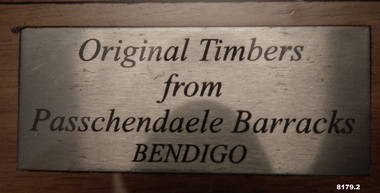
... building Depot was closed down and dismantled with the unit based there moved out to the new “Multi User Depot in Junortoun”. The tables were made in Bendigo and placed in the new Meeting Room of the Bendigo District RSL in Havilah Road which was named “Kokoda Room”. In another round of renovations...building Depot was closed down and dismantled with the unit based there moved out to the new “Multi User Depot in Junortoun”. The tables were made in Bendigo and placed in the new Meeting Room of the Bendigo District RSL in Havilah Road which was named “Kokoda Room”. In another round of renovations ...The centre Timbers under the glass tops came from the old Passchendaele Barracks building in Mollison Street Bendigo. The old building dated back to 1916. The building Depot was closed down and dismantled with the unit based there moved out to the new “Multi User Depot in Junortoun”. The tables were made in Bendigo and placed in the new Meeting Room of the Bendigo District RSL in Havilah Road which was named “Kokoda Room”. In another round of renovations to the Club the two tables were placed in the Soldier's Memorial Museum Pall Mall now Bendigo Military Museum. One was placed in the old Meeting room which at that time was part of the Museum, the second was placed in the old kitchen which had been converted into an BDRSL Office. With more renovations the two tables were returned to the Bendigo District RSL in a new meeting room. The two computer insets for cabling was then put into the tables. .1) .2) Two tables solid construction brown stain colour, the top has in inset of Timbers narrow a lighter brown stain laying across the width dimension, a glass top sits over these Timbers level with the heavy outside frame. Each table has an inset centre to accomodate computer cabling. There is a small plaque on each table.On the small plaques, “ Original Timbers from Passchendaele Barracks Bendigo”.brsl, smirsl, bdrslinc -
 Bendigo Military Museum
Plaque - RECOGNITION PLAQUES 2011, C.2011
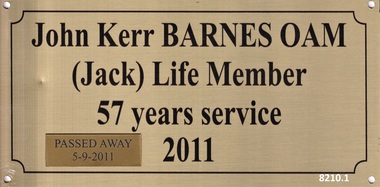
... These 3 plaques were originally placed on 3 doors within the Soldiers Memorial Institute building in Pall Mall Bendigo in recognition of the years of service as volunteers to the Bendigo RSL Sub Branch & Bendigo District RSL Sub Branch in 2011. Over time the small plaques were added regarding their ongoing volunteer years and passing. During the renovations...Bendigo Military Museum 37 - 39 Pall Mall Bendigo goldfields These 3 plaques were originally placed on 3 doors within the Soldiers Memorial Institute building in Pall Mall Bendigo in recognition of the years of service as volunteers to the Bendigo RSL Sub Branch & Bendigo District RSL Sub Branch in 2011. Over time the small plaques were added regarding their ongoing volunteer years and passing. During the renovations ...These 3 plaques were originally placed on 3 doors within the Soldiers Memorial Institute building in Pall Mall Bendigo in recognition of the years of service as volunteers to the Bendigo RSL Sub Branch & Bendigo District RSL Sub Branch in 2011. Over time the small plaques were added regarding their ongoing volunteer years and passing. During the renovations to the Soldiers Memorial Institute & Museum which closed in 2016 all plaques were taken down that were in the building. These 3 were not put back in the original positions. .1) John Kerr Barnes OAM, refer Cat No 8040 for his volunteer service. .2) John Edward Fay, refer Cat No 8129P for his volunteer service. .3) William James Norman Smart, refer Cat No 8131.2P for his volunteer service..1) Plaque, metal, front face gold colour, all text and edging in black, one small gold plaque placed on the bottom RH corner. .2) Plaque, metal, front face gold colour, all text and edging in black, 3 small gold colour plaques have been added. .3) Plaque, metal, front face gold colour, all text and edging in black, 2 small gold colour plaques have been added.brsl, smirsl, plaque, recognition, volunteer -
 Kiewa Valley Historical Society
Photos - Mt Beauty Buildings in 1973. Set of 8, 1973
... buildings and streetscape, have undergone significant changes since 1973. The kindergarten has undergone extensive remodelling, The Chalet has been replaced by Svarmisk Resort and Accommodation Spa. Tawonga hospital has undergone extensive renovation...buildings and streetscape, have undergone significant changes since 1973. The kindergarten has undergone extensive remodelling, The Chalet has been replaced by Svarmisk Resort and Accommodation Spa. Tawonga hospital has undergone extensive renovation ...The shopping centre in Mt Beauty, both buildings and streetscape, have undergone significant changes since 1973. The kindergarten has undergone extensive remodelling, The Chalet has been replaced by Svarmisk Resort and Accommodation Spa. Tawonga hospital has undergone extensive renovation and is now Mt Beauty Hospital AND Kiewa Valley House. The Workman’s Club changed name to the Country Club and has since closed down. Hospital and Kiewa Valley House now occupy what is shown as a vacant lot opposite the motel which is now called Mt Beauty Motor Inn.The houses in Mt Beauty were brought in by the State Electricity Commission of Victoria when they constructed Mt Beauty Town for their workers building the Kiewa Hydro Electric Scheme. Mt Beauty is unique began as a construction town in the late 1940's.Colour photographs of various buildings in Mt Beauty taken in 1973 1. Workman’s Club 2. View over the pondage 3. Tawonga Hospital (Mt Beauty) 4. Mt Beauty Chalet 5. Mt Beauty Kindergarten 6. The Merjei Motel 7. 8 Valley Avenue 8. Shopping Centre Handwritten in ink on the back of photos 1. Workman’s Club 1973 (after the brick makeover) From the sports oval – the high school is to the right 2. A view over the pond 1973 3. Tawonga Hospital 1973 (Mt Beauty) 4. Mount Beauty Chalet 1973 5. Kindergarten 1973 6. The Merjei Motel 1973 7. Our house at 8 Valley Ave 1973, Owner after us erected the car port, let the front hedge run amok and vanquished the vegetable garden and citrus trees Dad created. 8. Shopping Centre 1973. At the end of the street is the hospital (believe it is now Mt Beauty Bush Nursing Hotel) mt beauty, workman's club, chalet, tawonga hospital -
 Kiewa Valley Historical Society
Photographs x 2 - Mount Beauty Infant Welfare Centre, February 1994
... buildings in the Mt Beauty area, their uses and how they have changed to meet the changing needs of the community. Mt Beauty Infant Welfare Centre Printed at bottom of page underneath photos - Mt Beauty Infant Welfare Centre February 1994. Replacement of tile roof with Colourbond corrugated iron and construction of covered entry porch. 2 x colour photographs of renovations ...During the 1950's, Mt Beauty's population was rapidly increasing due to the post war baby boom and because there was a young workforce moving into the area due to the opportunity available for work on the construction of the Kiewa Hydro Electric Scheme. Maternal Infant Welfare Centre Sisters conducted regular check-ups on babies to ensure they were feeding well, gaining weight and reaching appropriate milestones for their age.Infants and young children in the Kiewa Valley area continue to be monitored by the Maternal Health Nurses to ensure their healthy development. The photographs are an historical record of early buildings in the Mt Beauty area, their uses and how they have changed to meet the changing needs of the community.2 x colour photographs of renovations to Mt Beauty Infant Welfare Centre. Mounted on white A4 copy paperPrinted at bottom of page underneath photos - Mt Beauty Infant Welfare Centre February 1994. Replacement of tile roof with Colourbond corrugated iron and construction of covered entry porch.mt beauty, infant welfare centre -
 Kiewa Valley Historical Society
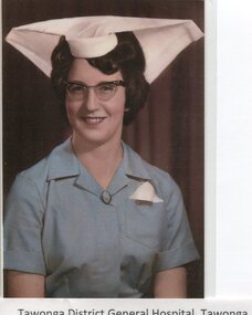
Photographs - Tawonga District General Hospital - Set of 21
... building; 19. The rear of the Tawonga District General Hospital and Matron’s house seen from Holland St, Mt Beauty during a snow storm in the mid 1960’s; 21. Tawonga District General Hospital & Kiewa Valley House, 2000. 1. Early nurses uniform; 2. Hospital Opening Ceremony; 3-7. Nursing Staff; 8. Delivery Room; 9. Mens Ward; 10.Enclosed Veranda; 11. Main Ward; 12-13. Kitchen; 14. Opening Ceremony 1949; 15.Original Hospital at Tawonga; 16-18. Relocated Hospital at Mt Beauty; 19. Rear of hospital and Matron’s quarters; 20. Hospital and Kiewa Valley House; 21. Renovated ...In the early stages of the Kiewa Hydro-Electric Scheme the State Electricity Commission took over the financial and construction responsibility of the Tawonga District General Hospital building at a cost of 27,000 pounds. This included the removal and re-erection of the ex-military Bonegilla ward from Wodonga while in addition they carried out all the necessary building works that allowed the hospital to operate as a functional unit. The work was completed and handed over to the Hospital Committee of Management on September 1, 1949. Local residents raised 3,400 pounds through fund raising. The balance was met by the SEC and the Hospital and Charities Commission. The initial project was to provide for a basic temporary hospital which was later to include an Operating Theatre, Offices, Store, Mortuary and a Nurse’s Home, until the establishment of a permanent medical premises. Following the opening, 455 patients were admitted to the Tawonga District General Hospital and 254 operations were performed in the first year. The hospital relocated to Mount Beauty in the former SEC administration offices located in the town centre. Official opening of the 18 bed Tawonga District General Hospital on April 29 in 1961. Alpine Health CEO Mr Lyndon Seys oversaw the opening of the new Mount Beauty Hospital in November 2001 alongside Board of Management President Mr Andrew Randell, other board members and politicians. The Kiewa Hydro-Electric Scheme the State Electricity Commission played a pivotal part in the planning and initial funding of the Tawonga District General Hospital, with a view to providing medical support for its many workers on the Hydro scheme. Later, spouse and family members of workers were also able to access medical assistance The hospital was originally located in Tawonga away from the majority of the patients as the Hospital and Charities Board was not prepared to have it within the SEC controlled area. It was not until the gate at Tawonga South was taken down that the hospital was moved to the main centre of population at Mount Beauty. 1. Early nurses uniform; 2. Hospital Opening Ceremony; 3-7. Nursing Staff; 8. Delivery Room; 9. Mens Ward; 10.Enclosed Veranda; 11. Main Ward; 12-13. Kitchen; 14. Opening Ceremony 1949; 15.Original Hospital at Tawonga; 16-18. Relocated Hospital at Mt Beauty; 19. Rear of hospital and Matron’s quarters; 20. Hospital and Kiewa Valley House; 21. Renovated Hospital in 20001.Tawonga District General Hospital Tawonga; 2. Kiewa construction engineer Mr HHC Williams speaking at the opening of the hospital. Health Minister the Hon CP Gartside performed the official opening. L to R: TH Mitchell MLA; Manager of the hospital Mr RH Kronberg (obscured) Hon CP Gartside; CL McVilley; LT Knevitt; Matron AI Tarnish & W Sealey: 4. Dedicated Nursing Staff; 5. Nurse Campbell (nee Reid); 6. Sister Seager 1955 (nee Janice Burnett. First District Nurse; 7. L to R: Sister F Rosengrove; Sister J Griffiths; Matron AI Tarnish; Nurse D Satori; Nurse D Tregonning; Sister E Hill & Sister S O’Shannessy; 8. In the early years Tawonga District General Hospital had the second highest birth rate in Australia; 9. The men’s ward catered for men only in the early years of the hospitals operation; 10. The enclosed verandah at the original Tawonga District General Hospital allowed for an additional 10 beds; 11. Tawonga District General Hospital, Tawonga Main Ward. Ward ready and waiting for patients at Tawonga Hospital. Complete with lovely vases of flowers for every bed. Nice touch by the nurses; 12. Kitchen of Tawonga District General Hospital, Mt Beauty. The hospital kitchen provided meals for patients and a 3 course dinner for Meals on Wheels. In 1977, 11,795 meals were produced at an average cost of $2.60 per meal; 13. Tawonga District General Hospital, Tawonga. Kitchen. Kitchen staff employed in the old Tawonga District General Hospital 1949-1961; 14. The official opening ceremony of the Tawonga District General Hospital, 1949. The official ceremony was attended by a large number of residents and Tawonga District General Hospital was open for public inspection; 15. Original Tawonga District General Hospital transported form Bonegilla began operations in 1949; 16. In 1961, the Tawonga District General Hospital relocated to take a central position in the town of Mt Beauty in the former SEC Administration building; 19. The rear of the Tawonga District General Hospital and Matron’s house seen from Holland St, Mt Beauty during a snow storm in the mid 1960’s; 21. Tawonga District General Hospital & Kiewa Valley House, 2000. tawonga district hospital, mt beauty hospital, medical, health care, s.e.c. -
 Bendigo Military Museum
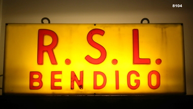
Sign - ILLUMINATED, RSL BENDIGO, pre 1990's
... building in Pall Mall Bendigo. It was in the centre space of the Portico. It was taken down approximately 1999 - 2000 due to damage. It was then put in storage and when the Renovations...building in Pall Mall Bendigo. It was in the centre space of the Portico. It was taken down approximately 1999 - 2000 due to damage. It was then put in storage and when the Renovations ...This sign was situated outside the Soldiers Memorial Institute building in Pall Mall Bendigo. It was in the centre space of the Portico. It was taken down approximately 1999 - 2000 due to damage. It was then put in storage and when the Renovations were completed to the SMI in 2018 it was then placed in what is now the Building/RSL/history room of the Bendigo Military Museum SMI.Sign, timber rectangular shape construction, illuminated face on both sides, faces are yellow background with red text "RSL BENDIGO", illumination is via one globe, at the top are two eyelets for holding in place.brsl, smirsl, sign, rsl bendigo -
 Bendigo Military Museum
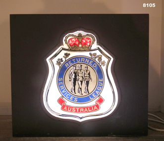
Sign - ILLUMINATED, RSL LOGO, pre 1990's
... After the renovations to the Soldiers memorial in 2018 it was placed in what is now the Building & RSL History room of the BMM....After the renovations to the Soldiers memorial in 2018 it was placed in what is now the Building & RSL History room of the BMM. brsl smirsl sign rsl logo "Returned Services League Australia" Sign, timber construction box shape, illuminated faces front and rear with the RSL Logo in colour. ...This sign was used in the Billiard room of the Soldiers Memorial Institute Bendigo RSL. Years ago when the Billiard room had a section divided off for part of a Caretakers Residence it was placed on the internal roof of the residence. It was mainly used at RSL meetings. When the RSL Meetings moved to the B&DRSL Club Inc it was used during the day when the Museum was open. After the renovations to the Soldiers memorial in 2018 it was placed in what is now the Building & RSL History room of the BMM.Sign, timber construction box shape, illuminated faces front and rear with the RSL Logo in colour. Illumination is via a single globe."Returned Services League Australia"brsl, smirsl, sign, rsl logo -
 Bendigo Military Museum
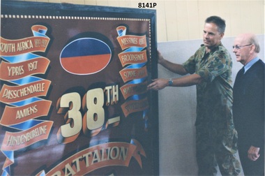
Photograph - 38th BATTALION BATTLE HONOURS, C. Jan 1999
... building in January 1999. The 38th Battalion AIF was known as Bendigo's own, raised in Bendigo in 1916 for service in the Great War. Due to its size it was placed high up in what was the Billiard Room in the Museum. After a major renovation...building in January 1999. The 38th Battalion AIF was known as Bendigo's own, raised in Bendigo in 1916 for service in the Great War. Due to its size it was placed high up in what was the Billiard Room in the Museum. After a major renovation ...The Officer in Uniform was Major Phil Chapman OC of 15th Transport Sqd based in Bendigo in the old Passchendaele Barracks depot in Mollison Street where the Battle Honour board was held. The other in civilian clothes is Cliff Richards who was Junior Vice President of the Bendigo RSL Sub Branch at the time. The photo relates to the Board being donated to the Bendigo RSL Museum in the SMI building in January 1999. The 38th Battalion AIF was known as Bendigo's own, raised in Bendigo in 1916 for service in the Great War. Due to its size it was placed high up in what was the Billiard Room in the Museum. After a major renovation to the BDRSL Inc Club in Havilah Rd in 2013 it was then placed over the foyer front entrance. Due to another up grade it was placed in storage for awhile and is now on display in the rear foyer patrons entrance. Refer Cat No 8176.Photograph colour showing one person in military uniform and another in civilian clothes, the Officer is steadying the 38th Battalion Battle honours board.On rear in black pen, "Jan 99 C Richards Jnr Vice - Major Chapman OC 15th Tpt Platoon".brsl, smirsl, 38th -
 Kiewa Valley Historical Society
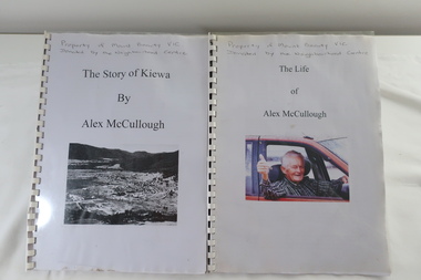
Alex McCullough Collection - Notes and Photos on History of Mt Beauty
... renovation of the Mt Beauty Neighbourhood Centre mid 2001. Four photos are labelled by Alex McCullough on the back. Also, photos of various sizes both colored and black and white depicting sites and people in Mt Beauty. Not labelled.Also, six packets of negatives of older photos incl. Community Hall, Fire Brigade, School, School ski group, Back to Kiewa, Alpine Study, D) Alex McCulloughs 1951 Diary - Clover Dam E) Random Items from History Profile Kiewa by Alex McCullough F) Papers - 'Administration of Mt Beauty Township' - 2nd July 1957. SECV buildings...renovation of the Mt Beauty Neighbourhood Centre mid 2001. Four photos are labelled by Alex McCullough on the back. Also, photos of various sizes both colored and black and white depicting sites and people in Mt Beauty. Not labelled.Also, six packets of negatives of older photos incl. Community Hall, Fire Brigade, School, School ski group, Back to Kiewa, Alpine Study, D) Alex McCulloughs 1951 Diary - Clover Dam E) Random Items from History Profile Kiewa by Alex McCullough F) Papers - 'Administration of Mt Beauty Township' - 2nd July 1957. SECV buildings ...Alex McCullough was a resident of Mt Beauty for many years and wrote a book on the History of Mt Beauty. Mt Beauty was constructed by the State Electricity Commission of Victoria to house employees working on the Kiewa Hydro Electric Scheme. Alex was involved with many organisations in Mt Beauty and interested in history. He took many photos of events and new developments in town. He also collected individuals memoirs on life in the town.Mt Beauty's history is unique as it was built as a construction town in the late 1940s. The information in Alex's Collection records the town's development perhaps in more detail than in his book "The History of Mt Beauty". His folder includes his education, his work with the SECV (foreman working on Clover Dam), his war service, his community work (Mt Beauty & District Progress Association & Mt Beauty Neighbourhood Centre) and awards, work as Shire Councillor and Mayor, sporting (tennis & golf) interests. Alexander John McCullough 1916 - 2011's obituary is online ref. legacy.comA) Booklet - The Life of Alex McCullough B) Booklet - The Story of Kiewa by Alex McCullough C) Coloured photos 15cm x 10 cm of the renovation of the Mt Beauty Neighbourhood Centre mid 2001. Four photos are labelled by Alex McCullough on the back. Also, photos of various sizes both colored and black and white depicting sites and people in Mt Beauty. Not labelled.Also, six packets of negatives of older photos incl. Community Hall, Fire Brigade, School, School ski group, Back to Kiewa, Alpine Study, D) Alex McCulloughs 1951 Diary - Clover Dam E) Random Items from History Profile Kiewa by Alex McCullough F) Papers - 'Administration of Mt Beauty Township' - 2nd July 1957. SECV buildings in Mt Beauty shared with community groups notes re - arrangement between groups. G) Barrie Wilcox's Memories living in Marum's paddock from c1940s onwards. Written in June 1999 H) Mt Beauty website June 1998 - a lot of history I) Papers - Mt Beauty High School band developement J) The 1950s Development of the Birth of Community support organisations K) Community Centre Mt Beauty opening 3rd August 1951 L) Mt Beauty Fire Brigade History M) Folder Personal papers re Alex McCullough alex mccullough, mt beauty history, community work -
 Bendigo Military Museum
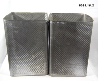
Container - KEROSENE TINS, pre 1990
... building. It was made from Chicory Essence coffee, milk and a small amount of water, a bottle of Rum was added to each when near ready. These were used for many, many years up until about 2006 when new containers were used. The old kitchen was removed in the Renovations...building. It was made from Chicory Essence coffee, milk and a small amount of water, a bottle of Rum was added to each when near ready. These were used for many, many years up until about 2006 when new containers were used. The old kitchen was removed in the Renovations ...These four tins were used to make the ANZAC Day rum and coffee at the Soldiers Memorial Institute Hall to be served after the Dawn Service. (Bendigo RSL Sub - Branch) It was brewed on the electric stoves in the old kitchen on the side of the building. It was made from Chicory Essence coffee, milk and a small amount of water, a bottle of Rum was added to each when near ready. These were used for many, many years up until about 2006 when new containers were used. The old kitchen was removed in the Renovations to SMI in 2016 - 2018 as it was not part of the original building..1) - .4) Kerosene tins, metals, open at one end.brsl, smirsl, rum, coffee -
 Bendigo Military Museum
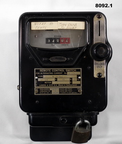
Functional object - HEATER METERS, ONE SHILLING, Landis & GYRS.A, Pre 1970
... Building & History room. it was attached to the LH side of the Fire Place and ran an old Electric Heater on the Hearth. It was used up to about 2005. .2) This one was in the Old Kitchen built on the side of the Soldiers Memorial Institute in the mid 1960's This one ran the Electric stoves used by the Womens Auxiliary of the Bendigo RSL and to make the Rum & Coffee for the ANZAC Day Dawn service. The kitchen was removed as part of the Renovations...Building & History room. it was attached to the LH side of the Fire Place and ran an old Electric Heater on the Hearth. It was used up to about 2005. .2) This one was in the Old Kitchen built on the side of the Soldiers Memorial Institute in the mid 1960's This one ran the Electric stoves used by the Womens Auxiliary of the Bendigo RSL and to make the Rum & Coffee for the ANZAC Day Dawn service. The kitchen was removed as part of the Renovations ....1) This one was used in the Writing room which later became a Meeting room then finally the RSL Building & History room. it was attached to the LH side of the Fire Place and ran an old Electric Heater on the Hearth. It was used up to about 2005. .2) This one was in the Old Kitchen built on the side of the Soldiers Memorial Institute in the mid 1960's This one ran the Electric stoves used by the Womens Auxiliary of the Bendigo RSL and to make the Rum & Coffee for the ANZAC Day Dawn service. The kitchen was removed as part of the Renovations in 2016 - 18..1) Heater meter, metal construction black coating, top face has a glass section with a "usage meter" saying "coins paid, unused", metal plate under with details re numbers, maker, coins per hour, on right side slot for "Shillings only" with knob, removeable lockable tray at bottom for coin storage and removing. .2)Same style as .1) but a different glass face style metering, it has 11 circular dials with one hand, these show "Coins paid, coins unused", this one shows the round meter going around when in use. The only differance between to two shapes is at the top re fixing to a wall..1) On plate, "Remote Control Switch - for alternating switch No 26 204 020 - Type Wik 36.1 - Adjustable 1-6 coins per hour, Adjusted for 1 coin per hour" On stickers, "insert 10 cents - Turn knob to right". .2) On glass section, "230/240 revs per KWH - 1200 - Serial No 8338380 - 5 - 50". On label stuck on, "10 c equals 1/2 hour"brsl, smirsl, shilling -
 Bendigo Military Museum
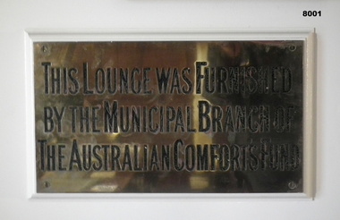
Plaque - AUSTRALIAN COMFORTS FUND, Australian Comforts fund, C.1921
... After the renovations to the SMI 2016 - 18 it was placed in what was originally called "The Writing Room" now named "The Building and RSL History Room"...After the renovations to the SMI 2016 - 18 it was placed in what was originally called "The Writing Room" now named "The Building and RSL History Room" brsl smirsl Comforts "This Lounge was furnished by the Municipal Branch of the Australian Comforts Fund" Plaque brass with engraved writing in black attached by 4 screws to a backing piece on a wall. ...This plaque was originally placed in the Foyer (or vestibule on the original plans) of the Soldiers Memorial Institute Bendigo in 1921. After the renovations to the SMI 2016 - 18 it was placed in what was originally called "The Writing Room" now named "The Building and RSL History Room"Plaque brass with engraved writing in black attached by 4 screws to a backing piece on a wall."This Lounge was furnished by the Municipal Branch of the Australian Comforts Fund"brsl, smirsl, comforts -
 Bendigo Military Museum
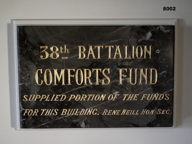
Plaque - 38TH BN COMFORTS FUND, 38th Battalion Comforts Fund, C.1921
... After closure in 2016-18 for the renovations to SMI the plaque was then placed in what was originally called the "Writing Room" now called "The Building and RSL History Room". ...After closure in 2016-18 for the renovations to SMI the plaque was then placed in what was originally called the "Writing Room" now called "The Building and RSL History Room". ...This plaque was originally placed in the Foyer (Vestibule on original plans) of the Soldiers Memorial Institute Bendigo in 1921. After closure in 2016-18 for the renovations to SMI the plaque was then placed in what was originally called the "Writing Room" now called "The Building and RSL History Room". The plaque had the gold paint renewed about 2012 - 15.Plaque marble, grey with streaks of white through, inscription is engraved with Gold paint. The plaque is attached via 2 screws to a backing board on a wall."38th BATTALION COMFORTS FUND supplied portion of the funds for this building. Rene Neill Hon Sec"brsl, smirsl, 38th -
 Bendigo Military Museum
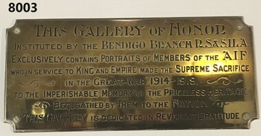
Plaque - GALLERY OF HONOUR, Returned Soldiers & Sailors Imperial League of Australia, c. 1921 onwards
... After the closure of the SMI for renovations 2016 - 18 the plaque was placed in what was originally called "The Writing Room" now called "The Building and RSL history Room"...After the closure of the SMI for renovations 2016 - 18 the plaque was placed in what was originally called "The Writing Room" now called "The Building and RSL history Room" brsl smirsl Plaque “THIS GALLERY of HONOR Instituted by the Bendigo Branch of the RS&SILA exclusively contains portraits of members of the AIF who in the service to King and Empire made the supreme sacrifice in the Great War 1914 - 1919 into the imperishable memory of the priceless heritage beqeathed by them to the nation. ...This plaque was originally in the Foyer (vestibule on the original plans) of the Soldiers Memorial Institute Bendigo to compliment framed photos of Soldiers who never came home from the Great War. This was unveiled on ANZAC Day 1927. After the closure of the SMI for renovations 2016 - 18 the plaque was placed in what was originally called "The Writing Room" now called "The Building and RSL history Room"Plaque brass with curved corners with inscribed text in black with several scrolls around. Plaque is attached via 4 screws to a backing board onto a wall.“THIS GALLERY of HONOR Instituted by the Bendigo Branch of the RS&SILA exclusively contains portraits of members of the AIF who in the service to King and Empire made the supreme sacrifice in the Great War 1914 - 1919 into the imperishable memory of the priceless heritage beqeathed by them to the nation. This Gallery is dedicated in reverent gratitude”brsl, smirsl, plaque -
 Bendigo Military Museum
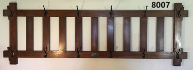
Domestic object - COAT AND HAT RACK, Pioneer Comforts Fund, c. 1921
... After the renovations to SMI 2016 - 18 it was placed back in the same position. This room is now called the "Building and RSL History Museum....After the renovations to SMI 2016 - 18 it was placed back in the same position. This room is now called the "Building and RSL History Museum. brsl smirsl Comforts On the plaque, "Presented by the Pioneer Comforts Fund" Coat and hat rack timber construction rectangular shape, has six hangars at top and six at the bottom. ...This item was placed in what was originally the "Writing Room" of the Soldiers Memorial Institute Bendigo when it was opened in 1921. After the renovations to SMI 2016 - 18 it was placed back in the same position. This room is now called the "Building and RSL History Museum.Coat and hat rack timber construction rectangular shape, has six hangars at top and six at the bottom. Each hangar holds two items, top hangars are different style to the bottom. A small silver oval plaque is central at the bottom.On the plaque, "Presented by the Pioneer Comforts Fund"brsl, smirsl, comforts -
 Bendigo Military Museum
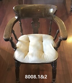
Furniture - OFFICE CHAIRS, Melbourne -------Co Pty, Collingwood, C.1921
... After the renovations to SMI in 2016 -18 they were then placed in what is now called the "Building and RSL History Room"...After the renovations to SMI in 2016 -18 they were then placed in what is now called the "Building and RSL History Room" brsl smirsl Comforts Under both seats just readable, "Melbourne ------ Co PTY --2 Down St Collingwood - European labour only" .1) & .2) Captain style chairs, solid timber construction, curved arm rests and heavy back rest. .3) .4) Padded cushions of white colour, one is very old the other purchased about 2007 to match. ...These Office chairs were originally placed in the front Office of the Soldiers Memorial Institute in 1921funded by the "Australian Mining Comforts Fund" and remained in use till approx 2012 when the Office was renovated. After the renovations to SMI in 2016 -18 they were then placed in what is now called the "Building and RSL History Room".1) & .2) Captain style chairs, solid timber construction, curved arm rests and heavy back rest. .3) .4) Padded cushions of white colour, one is very old the other purchased about 2007 to match.Under both seats just readable, "Melbourne ------ Co PTY --2 Down St Collingwood - European labour only"brsl, smirsl, comforts -
 Bendigo Military Museum
Furniture - OFFICE DESK, c.1921
... After the renovations to SMI in 2016 - 18 it was installed in what is now called the "Building and RSL History Room"...After the renovations to SMI in 2016 - 18 it was installed in what is now called the "Building and RSL History Room" brsl smirsl Comforts Office desk, heavy timber construction rectangular shape, has two pull out side drawer's that originally had a filing system in, one pullout drawer central in the sit position. ...This table was installed originally in the front office of the Soldiers Memorial Institute Bendigo 1921 funded by the "Australian Mining Comforts Fund". It was still in use up till approx 2012 when the office was renovated. After the renovations to SMI in 2016 - 18 it was installed in what is now called the "Building and RSL History Room"Office desk, heavy timber construction rectangular shape, has two pull out side drawer's that originally had a filing system in, one pullout drawer central in the sit position. Side drawers have steel handles, central one timber.brsl, smirsl, comforts -
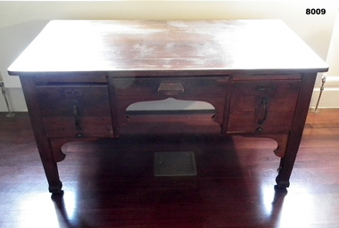
 Bendigo Military Museum
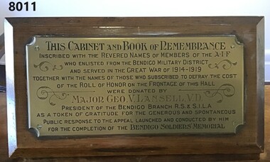
Furniture - GLASS TOP CABINET, Major George LANSELL VD, C.1926
... After the renovations to the SMI 2016 - 18 it was then placed in what is now the "Building and RSL History Room"...After the renovations to the SMI 2016 - 18 it was then placed in what is now the "Building and RSL History Room" brsl smirsl Remembrance "THIS CABINET and BOOK of REMEMBRANCE inscribed with the revered names of members of the AIF who enlisted from the Bendigo Military District and served in the GREAT WAR of 1914 - 1919 together with the names of those who subscribed to defray the cost of the Roll of HONOR on the FRONTAGE of this HALL were donated by MAJOR GEO.V.L. ...This cabinet with the "Book of Remembrance" (refer Cat No 8010) was originally placed in the foyer (vestibule) of the Soldiers Memorial Institute Bendigo in 1926. After the renovations to the SMI 2016 - 18 it was then placed in what is now the "Building and RSL History Room"Cabinet heavy timber construction with four legs, has a glass top that opens at the front and lockable. Has a red felt inset for the "BOOK of REMEMBRANCE". At the back of the cabinet set at an angle is a brass plaque with an inscription in black and red with scrolls around. The plaque is on a timber backing attached to the cabinet."THIS CABINET and BOOK of REMEMBRANCE inscribed with the revered names of members of the AIF who enlisted from the Bendigo Military District and served in the GREAT WAR of 1914 - 1919 together with the names of those who subscribed to defray the cost of the Roll of HONOR on the FRONTAGE of this HALL were donated by MAJOR GEO.V.L. LANSELL, V.D. PRESIDENT of the BENDIGO R.S & S.I.L.A as a token of gratitude for the generous and spontaneous public response to the appeal launched and conducted by him for the completion of the BENDIGO SOLDIERS MEMORIAL"brsl, smirsl, remembrance -
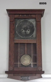
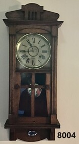 Bendigo Military Museum
Domestic object - CLOCK, WALL PENDULUM, Gilbert Clock Co, C. 1918 - 1921
... After the renovations to the SMI in 2016 - 18 the clock was placed back in the same position in what is now called "The Building and RSL History Room"....After the renovations to the SMI in 2016 - 18 the clock was placed back in the same position in what is now called "The Building and RSL History Room". brsl smirsl Domestic On clock face under hands, "J.T. ...This clock was placed in what was called the "Writing Room" of the Soldiers Memorial Institute when it was opened in 1921. After the renovations to the SMI in 2016 - 18 the clock was placed back in the same position in what is now called "The Building and RSL History Room".Pendulum Wall Clock, timber frame with glass front insets in door, clock face has Roman Numerals, chimes on the hour and half hour, wind up key inside. A small silver plaque is on the front bottom space.On clock face under hands, "J.T. Knowlton & Co watch makers Bendigo". Around edge of clock face, "W.M.L Gilbert Clock Co Winsted Conn U.S.A" On small Plaque, "Presented by Pioneer Comforts Fund 15.11.1921"brsl, smirsl, domestic -
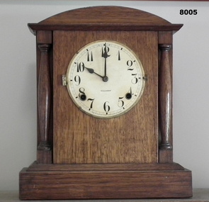 Bendigo Military Museum
Domestic object - CLOCK, MANTLE PIECE, Gilbert Clock Co. U.S.A, possible 1918 - 1921
... After the renovations to the SMI in 2016 - 18 it was placed on the mantlepiece of the fireplace in what is now called "The Building and RSL History Room"...After the renovations to the SMI in 2016 - 18 it was placed on the mantlepiece of the fireplace in what is now called "The Building and RSL History Room" brsl smirsl Mantle On Clock face, "Gilbert". ...This clock was originally in the front Office of the Soldiers Memorial Institute Bendigo on the mantlepiece of the fireplace. Original donor or date of being placed is unknown. It was last used in 2005 by Jack Barnes OAM who wound it every day he was in the Office, he was Secretary for 43 years of the BRSL. After the renovations to the SMI in 2016 - 18 it was placed on the mantlepiece of the fireplace in what is now called "The Building and RSL History Room"Mantle Piece Clock, timber frame, hinged glass cover over the face is missing, numbers are 1 - 12 on clock face, rear door to the mechanism, a pendulum weight is taped to the inside, no wind up key.On Clock face, "Gilbert". Around clock face, "Made in Winsted Conn United States of America"brsl, smirsl, mantle -
 Bendigo Military Museum
Domestic object - CLOCK, WALL, PENDULUM, Prescott & Dawe Bendigo, possibly pre war
... After the renovations to the SMI 2016 - 18 this clock was placed in what is now called the "Building and RSL History Room"...After the renovations to the SMI 2016 - 18 this clock was placed in what is now called the "Building and RSL History Room" brsl smirsl Domestic On clock face, "Prescott & Dawe". ...This clock was placed originally in what was called the "Billiard Room" of the Soldiers Memorial Institute Bendigo. There is no apparent connection to the RSL or Military service of F. Prescott. Frederick Napoli Prescott was a prominent Bendigo Optician and Jeweller at the corner of Mitchell and Hargreaves Street Bendigo. He was later in partnership with Mr C.M. Dawe trading as Prescott & Dawe. Mr Prescott died in 1913. After the renovations to the SMI 2016 - 18 this clock was placed in what is now called the "Building and RSL History Room"Pendulum wall clock timber frame with door on front, door has glass inset, each side has a glass inset, clock numbered 1 - 12, wind up key is inside, a small silver plaque is on the bottom front face.On clock face, "Prescott & Dawe". On plaque, " Presented by Mrs F Prescott in memory of F Prescott"brsl, smirsl, domestic -
 Emerald Museum & Nobelius Heritage Park
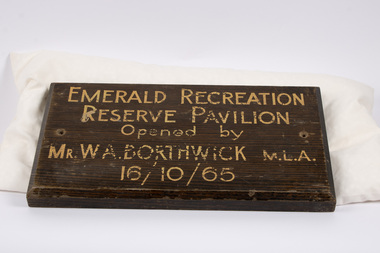
Plaque - Opening Plaque of Emerald Recreation Reserve Pavilion, 1965
... This plaque commemorates a now-renovated building playing an important role in facilitating sporting and recreation in the local community over more than five decades. ...This plaque commemorated the October 16th, 1965 opening of a new pavilion at Emerald Recreation Reserve (now known as Worrell Reserve). The pavilion was opened by Mr William Archibald Borthwick, at that time a member of the Victorian Legislative Assembly representing the electorate of Scoresby. It was built to serve the needs of local sports teams including the Emerald Cricket Club. The 1965 pavilion was replaced in 2021.This plaque commemorates a now-renovated building playing an important role in facilitating sporting and recreation in the local community over more than five decades.A rectangular wooden plaque, with partially faded text painted on one side in a landscape orientation. There are two holes through the display side of the plaque near the middle of each short edge, previously used to affix the plaque to a surface. There is a small taper between the rear side and display side such that the display side is slightly smaller.Painted on wood: "EMERALD RECREATION / RESERVE PAVILION / Opened by / MR. W A. BORTHWICK M.L.A. / 16/10/65"emerald cricket club, worrell reserve -
 Port of Echuca
Colour Photograph, Approx.1979
... The building was in disrepair until it was bought by the Port of Echuca and renovated to be turned into part of the Port of Echuca tourist exhibits and was leased out to be run as a restaurant....The building was purchased by the Port of Echuca to be part of the tourist attraction. It was extensively renovated to bring it back to its former glory. ...The Bridge Hotel was built by Henry Hopwood, founder of Echuca. The building was in disrepair until it was bought by the Port of Echuca and renovated to be turned into part of the Port of Echuca tourist exhibits and was leased out to be run as a restaurant.The Bridge Hotel is of historical and social significance to Echuca as it was built be Echuca's founder Henry Hopwood. The hotel was situated between the 2 rivers, Murray and Campaspe, where Hopwood ran his punt business, charging people and animals to cross the rivers. The hotel accommodated a variety of paying guest from wealthy squatters to salesmen and general workers. The building was purchased by the Port of Echuca to be part of the tourist attraction. It was extensively renovated to bring it back to its former glory. The Bridge hotel played an important role in the TV series "All the Rivers Run". Colour photograph of the Bridge Hotel, Echuca, after restorations (c.1979)On front of building : Bridge Hotel / Restaurant Printed on reverse:"This paper manufactured by Kodak"bridge hotel, echuca, port of echuca, echuca, victoria -history, henry hopwood -
 Port of Echuca
Photograph - Black and white photograph, Late 1970s
... renovated the hotel. The Bridge Hotel was built by Henry Hopwood in 1858. This and the Bond Store were Echuca's first 2 brick buildings. ...renovated the hotel. The Bridge Hotel was built by Henry Hopwood in 1858. This and the Bond Store were Echuca's first 2 brick buildings. ...Relates to a series of 5 photos:P000094-P000098 of the front of the Bridge Hotel on the corner of Murray esplanade and Hopwood gardens. These photos, taken about 1976, were before the Port Restoration Scheme renovated the hotel. The Bridge Hotel was built by Henry Hopwood in 1858. This and the Bond Store were Echuca's first 2 brick buildings. Named from Hopwood's nearby pontoon bridge. The building was bought be The Council in 1970. Restored and reopened in 1975.The Bridge Hotel is an important part of Echuca's settlement and development. It was originally built by Henry Hopwood, the European founder of Echuca, in 1859. Hopwood built the hotel to provide accommodation to people using his punts across the Campaspe and Murray rivers that area central to the landscape of the Port. The hotel was situated on the land between both rivers and punts and provided for a variety of levels of accommodation from grand rooms to very basic rooms. At the time of the photos the hotel was 120 years old and became an important part of the Port of Echuca tourism. Black and white photograph of the Bridge Hotel , showing western wing before restoration.Stamped on the reverse "Gazemore Studio, D. G. Gay, 18 Frances Street Echuca 3625.bridge hotel, echcua, port restoration scheme, bridge hotel restoration, echuca -
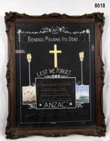 Bendigo Military Museum
Painting - BENDIGO MOURNS, FRAMED, Paul Sarony, C.1929
... After closure of the SMI for renovations 2016 - 18 the item was placed in what is now called the "Building and RSL History Room" William Darwin No 780 enlisted on 18.8.1914 age 22 years in G Coy 7th BN AIF. ...After closure of the SMI for renovations 2016 - 18 the item was placed in what is now called the "Building and RSL History Room" William Darwin No 780 enlisted on 18.8.1914 age 22 years in G Coy 7th BN AIF. ...This item was hung in the Gallery of Honour, foyer of the Soldiers Memorial Institute since 11.11.1929. Commissioned by Drum Major WM DARWIN to comrades & citizens of his native city, Bendigo. After closure of the SMI for renovations 2016 - 18 the item was placed in what is now called the "Building and RSL History Room" William Darwin No 780 enlisted on 18.8.1914 age 22 years in G Coy 7th BN AIF. Embark for Eygpt 19.10.1914, Hospital 15.3.1915 - 3.5.1915, embark for Gallipoli 5.4.1915, promoted to Act/Sgt 28.8.1915, on 28.9.1915 he was buried in an explosion and dug out 3/4 hours later, was unconcious for 2/3 days and had a leg wound. In amongst this he appears to have got Typhoid and never comes out of Hospital till 13.3.1916. He is returned to Australia and discharged medically unfit classed "Shell Shock".Rectangular dark brown ornate frame with glass, displaying a luminous painting. Pictured are 2 torches, a cross, a ship & a battlefield scene.“AIF. Bendigo Mourns Its Dead. Lest We Forget”brsl, smirsl, honors -
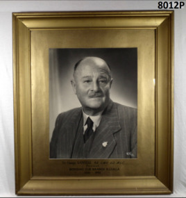 Bendigo Military Museum
Photograph - PORTRAIT, FRAMED, c.1950
... After the renovations to SMI 2016 -18 it was then placed in what is now called the "Building and RSL History Room". ...After the renovations to SMI 2016 -18 it was then placed in what is now called the "Building and RSL History Room". ...GEORGE VICTOR LANSELL is the longest serving President of the Bendigo RSL 1925 - 1952 and then 1954 - 57. He was awarded Life Membership and Life Membership with Gold Badge in 1956. This photo was originally hanging in the Billiard Room SMI. It was moved to the Foyer post 2000 to be with a plaque Cat No 8013. After the renovations to SMI 2016 -18 it was then placed in what is now called the "Building and RSL History Room". This is not the original photo that was placed in 1926. George Victor Lansell had prior service in the 67th Militia BN before WW1. He enlisted in the AIF with A Coy 38th Bn on 1.5.1916 age 32 years 7 months. He was appointed Coy Commander of A Coy. Embark for England 20.6.1916, hospital 19.8.1916 with Influenza, rejoin unit 25.8.1916, embark for France 22.11.1916, WIA 1.12.1916 grazed by a bullet to right forehead, suffering from concussion and other complications he was returned to Australia on 12.5.1917 and discharged from the AIF on 11.8.1917. Timber frame painted gold, black & white portrait of Sir George Lansell wearing a suit and tie, RSL badge on coat. Below photo: "Sir George Lansell KB CMG VD MLC President Bendigo Sub Branch RSSAILA” 1926-1951"brsl, smirsl, 38th -
 Ballarat Clarendon College
Framed items
... This building is currently in use, and recently renovated, as the senior staff room. ...This building is currently in use, and recently renovated, as the senior staff room. ...The original Weatherly Library was situated in the space immediately on the left of the archway. The fittings and furnishing of the library was a generous gift in 1936 of Mrs H P Mackenzie of Trawalla in honour of her pioneer parents, Mr and Mrs William Weatherly. The library was panelled with blackwood and fitted with shelves intended to eventually house 3000 books. Specially made solid blackwood chairs, upholstered in genuine hide, two long reading tables, an upholstered bench seat under the north window and an ornate carved mantelpiece topped by a classical broken pediment framing a carved head of Minerva were also donated. In 1971 this library was no longer large enought o serve the growing number of boys at the college; it was replaced by a bigger, separate building, also known as the Weatherly Library. This building is currently in use, and recently renovated, as the senior staff room. In 1993 a third library building was opened and named Erindale in recognition of property associated with Clarendon PLC. In 2012 the school opened the Fraser Library on the senior campus in honour of old collegian and school council chair, Darrell J Fraser. Wooden frames with mounts and glass; both include printed descriptions; one includes a black and white photographh p mackenzie, weatherly library -
 Federation University Historical Collection
Photograph, Renovation of the Summerscale Building, Sturt Street, Ballarat, c2003
... Barker Library (top floor) Mount Helen goldfields Summerscales building camp street sturt street Sumerscales building on the corner of Sturt Street and Camp Street, Ballarat. Renovation of the Summerscale Building, Sturt Street, Ballarat Photograph ...Sumerscales building on the corner of Sturt Street and Camp Street, Ballarat.summerscales building, camp street, sturt street -
 Federation University Historical Collection
Photograph, Delegates to the ANA Conference, 1947, 21/03/1947
... building was subdivided into a factory and a guesthouse called the Dysart Private Hotel. In 1961, it was again converted into the Reformed Theological College then later a private residence. In 2018 55 Maud Street had fallen into a state of disrepair, but was renovated...building was subdivided into a factory and a guesthouse called the Dysart Private Hotel. In 1961, it was again converted into the Reformed Theological College then later a private residence. In 2018 55 Maud Street had fallen into a state of disrepair, but was renovated ...Dysart is a Tudor Gothic building used as the original site of Geelong Grammar School. The Governor of Victoria, Sir Henry Barkly, laid its foundation stone in 1857 with the Bishop of Melbourne and the Archdeacon of Geelong in attendance. The student boarder population grew rapidly to call 55 Maud Street their home. After the school relocated to a larger site in 1914, the building was subdivided into a factory and a guesthouse called the Dysart Private Hotel. In 1961, it was again converted into the Reformed Theological College then later a private residence. In 2018 55 Maud Street had fallen into a state of disrepair, but was renovated to provide 28 premium dormitories in a peaceful and gorgeous setting.Small black and white photo.Verso "Taken oustise "Dysart" 21-3-47 Delegates ANA Conference 1947 Geelongana, australian natives association, geelong, dysart -
 Wycheproof & District Historical Society Inc.
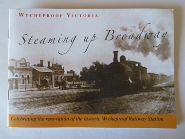
Railway Booklet, Steaming Up Broadway, 31/10/2010
... buildings and horse- drawn carriages showing. Back cover: Wycheproof Railway Station in its early beginnings - undated. Booklet celebrates the renovation...Renovation Steam-Train Booklet of 14 pages - size A5. Sepia front cover photo depicts steam train hauling rail trucks up Broadway, Wycheproof, with early buildings and horse- drawn carriages showing. ...Celebrating 125 years of Railway in WycheproofThe 28-09-1883 was a memorable date for Wycheproof for on that day the long-awaited official opening of the railway took place. It has been serving the district since then. In this booklet individual rail workers are acknowledged in a listing.Booklet of 14 pages - size A5. Sepia front cover photo depicts steam train hauling rail trucks up Broadway, Wycheproof, with early buildings and horse- drawn carriages showing. Back cover: Wycheproof Railway Station in its early beginnings - undated. Booklet celebrates the renovation of the historic Wycheproof Railway Station and 125 Years of Rail in Wycheproof. Chapters include: The Early Days, The Arrival of Rail, The New Century, Bulk Wheat and Million Bushell Silos, Railway Families and Workers, The Last Chapter , A new Era Begins. rail-wycheproof, bulk-wheat, railway-workers, station-renovation, steam-train