Showing 195 items matching "robert grant"
-
 Whitehorse Historical Society Inc.
Document, Crown Grant Register, 10/05/1999
Crown Grant Register - General Law - Parish of Nunawading, 1854 - 1858. Lands Department plan of Parish, 1864.land settlement, victoria. lands department, blood, robert, blood, thomas, burrell, charles, clisby, william, cook, charles, cousens, james, dickensen, william, harding, william, hedding, william, holland, john, jones, william, kefford, richard, lobb, john, morgan, robert rowland, morton, william, o'conner, patrick, orr, joseph, polak, nelson, riley, patrick, smith, l l dr, tranter, william, whitman, francis, williams, william, wilks, joseph, wilson, william, wilton, edward -
 Whitehorse Historical Society Inc.
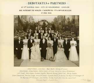
Photograph, Debutante Mayoral Ball, City of Nunawading, 17/06/194
Framed Black and white photo of Debutante Mayoral Ball, City of Nunawading, Mayor & Mayoress: Cr. & Mrs H.R. Seeger.shambrook, robert, gibson, robert, savage, winifred, cook, lois, mclennan, bruce, smith, basil, abbott, elizabeth, poulton, jack, mclannan, patricia, tainton, colin, knight, dorothy, tainton, velma, edwards, neil, lynch, walter, grant, joyce, cook, jill, seeger, rosemary, cox, kevin, rees, elizabeth, mitchelmore, betty, arnall jeff, kemp, mavis, chrystie, graham, ramsey, marcelle, crow, walter, sanders, shirley, debutante ball, city of nunawading, debutantes -
 Ballarat Heritage Services
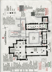
Plan, Lanercost Priory, Digital copy made 2016
Lanercost Priory was founded around 1169 by Robert de Vaux, and was home to an order of Augustinian canons until 1538 when is was dissolved by Henry VIII. In 1542 the priory and lands were granted to Thomas Dacre, an illegitimate son of Thomas, Lord Dacre. Mason's marks can be found throughout the undercroft. Plan on white paper with black and red ink printing and a drawingEnglish Heritage Lanercost Priorymason's marks, marks, stone marks, stonemasons, lanercost, priory, plan, 1169 -
Unions Ballarat
Robert E. Lee (Don Woodward Collection), Earle, Peter, 1973
Lee was a general of the South in the American Civil War and commanded the Army of Northern Virginia. He ultimately surrendered his army to Ulysses S. Grant. Historical (USA) and biographical interest.Book; 224 pages. Dust jacket: picture of Robert E. Lee on horseback and men flying the Battle Flag of the Army of Northern Virginia; author's name and title. Cover: red background; gold lettering; author's name and title on the spine. Red stamp, "Stock check 1985". Remains of a library loans slip - mostly torn out.btlc, ballarat trades and labour council, ballarat trades hall, lee, robert e., warfare - us civil war, history - usa, biography -
 City of Ballarat Libraries
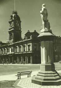
Photograph, Thomas Moore statue, and Town Hall, Sturt St, Ballarat
An image from the Herbert Richmond collection, gifted in 1982 to the Ballarat Library. The collection contains approximately 200 photographs of Ballarat and district in the 1940s, 50s and 60s, as well as photo albums, glass negatives and other memorabilia. Herb Richmond was a keen photographer, a foundation member and a life member of the Ballarat Camera Club, and a photographer with the Ballarat Courier during the 1940s. The Ballarat Camera Club named an annual award after him. Mr Richmond died in 1981 aged 79. These images were digitally re-photographed by members of the Ballarat Camera Club in September 2006. Thomas Moore was an Irish poet, the inspiration for this statue coming from the Irish people of Ballarat, soon after the Robert Burns statue was erected by the Scots. Sculpted by George Grant in 1889moore, thomas, begonia festival -
 Old Castlemaine Schoolboys Association Inc.
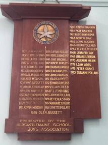
Honour Board, Elphinstone Primary School
1929 - J.L. Hughes 1930 - Elizabeth Bateman 1931 - R.J. Pollard 1932 - R. J Pollard 1933 - Lorna Ellery 1934 - R.H. Monkhouse 1935 - Allan Pollard 1936 - Alice McCristal 1937 - William E Bassett 1938 - Lillian Jean Pollard 1939 - June Mary Oxley 1940 - Mary E. Monkhouse 1941 - Gracie E.M. Clinton 1942 - Kenneth Pollard 1943 - Kevin Morrish 1944 - Clifford Pollard 1945 - Beryl. G. Rawlins 1946 - June Birchall 1947 - Robert Rawlins 1948 - Barbara Morrish 1949 - D. W. Rawlins 1950 - John S. Watson 1951 - Elsie O. Swift 1952 - Edward Rawlins 1953 - William Creed 1954 - F.L. Finning 1955 - John. W. Pollard 1956 - Peter R. Starr 1957 - Margaret Higgins 1958 - Lynette Pollard 1959 - Glen Bassett 1960 - Kelvin Bankin 1961 - Pam Bankin 1962 - Elizabeth Langridge 1963 - Not Awarded 1964 - Robyn Day 1965 - John Holden 1966 - Brian Pollard 1967 - Terese Holden 1968 - Jennifer Day 1969 - Lorraine Leversha 1970 - Julieanne Holden 1971 - Leah Ades 1972 - Peter Grant 1973 - Susanne Pollard -
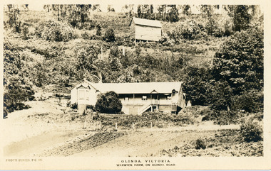 Mt Dandenong & District Historical Society Inc.
Photograph, Warwick Farm On Olinda Road
Information supplied by Stephen Trembath. Warwick Farm was established by my late grand parents Polly (nee Mary Ann Cole) and George Barratt and their 5 children George Jnr, William, James, John (my maternal Grand Father) and Teddy. Their story is told in a book "The wine of Courage" written in 1977 by N.M. Roberts ISBN 0 7223 1003. Their story started when their bank closed their doors on 13 April 1893 and they lost their cafe business in South Melbourne. Two days later, they were ready to head for a new start in Queensland when they saw in the morning paper that the Dandenong Ranges had been thrown open to land release to people. A few days later, having been granted land they headed to Ferntree Gully. From there they walked to the new holding in what would become Olinda. Then George with his sons help had to build a shelter for the family for the night. They chose to name the property "Warwick Farm". Work on the house started a few days later with help from neighbours Mr. Dodd, Mr Beattie, the O'Sheas and others. Come November, Ruby was born. Then bushfire burnt down the newly built house. Back to a bark hut until another house could be built. The new house became a guest house at the suggestion of a neighbour, when George couldn't sell timber and was waiting for crops. The first guests visited in 1898 and another baby, Percival, was born. ....................................................... It was George's son Jim, who was a skilled carpenter and axeman who extended the home to take from 12 to 30 guests. In 1950 Warwick Farm became the home of distinguished writer and journalist C.E.Sayers for a number of years.Photo Series Pictorial Postcard # 981 showing the property Warwick Farm on Olinda Road.Printed on back: PHOTO SERIES Pictorial Postcards. Published by S. Jamieson Bros. Alphington Vic. Phone Northcote 60warwick farm, olinda, postcard, photo series, olinda road, george barratt, barratt, guest house, guest house -
 Ballarat Tramway Museum
Document - List, Wayne Kell, "Ballarat Tramways Employees (60's - 71)", 2020
Yields information the employees of the SEC from about the 1960's through to closure. Not known if completely accurate.List - typed A4 sheet titled "Ballarat Tramways Employees (60's - 71)", prepared by Wayne Kell. Lists employees in alphabetical order images: .1 - jpg scan of the sheet .2 - pdf of the list in a single vertical column .3 - word document in the image files Noel Aghan Noel Allen Max Anderson Brian Anwyl Adam Balloch Ray Barrow Ian Bentley James Billman Les Bird Mick Blackman Kevin Blake Dave Blaw Brett Boddington Kevin Brookman Gary Butler Kevin Butler Marty Cahill Bob Carter Daryl Chambers R oy Courtney Steve Crosby Ray Curnow Ron Davidson Bill Davies S. Davies W. Davies T Ed Davis L. Denmead Max Devlin Austin Domaschenz Des Domaschenz T. Dunstan Ted Edmunds Allen Edwards George Etheridge D. Everett John Everett Ted Fish Vic Gill Ian Grant George Gray Max Green Ray Hall Norm Hamilton Rory Herauville Bernie Hill Colin Hill Norm Hunt Danny Irvine Allan Jeffreys Bruce Jenkins David Jones Ron Jordan Wayne Kell Alan Kellett Alf Kellett Dave Kellett Noel Klein Hec Knight Ron Knight Mick Laidlaw Ed Lake Stan Lakey Herb Lee George Long Norm Lorensini Geoff McErvale Doug McGregor Leo McMahon Alec McWilliam Bill Maes George Magee Jim Maher Mick Mahoney Andre Malins B. Mannion Les Mark Jack Marone Jackie Mason Arthur Maxwell Harold May Allan Meaney Brian Melville Jim Menzies Alf Mercer Barry Morris Robert Morris Bruce Munn Tom Nancarrow Bill Newell Les North John O’Keefe Dan O’Leary Dick Oliver Joel Owen Eric Patterson Bert Peart Ivan Pellas D. Powell Lindsay Quick Arthur Reed Bill Retallick Rex Rewell Howard Reynolds Neil Robe Ned Romeo Vin Ryan Rick Rykers Bill Segrave John Schmidt Charles Scicluna David Skewes Harry Smerdon Brian Smith Roy Smith Bill Spicer Tony Stephens Max Stephens Tom Stevenson Neil Sutherland Doug Thompson Ian Tierney Ian Trenfield John Truscott Bill Trusler Bill Tuddenham A. Turnbull Dave van Oorschot E. van Rooy Harry van Oorschot Henk van Oorschot Bill van Oorschot Gerry van Rooy Harry van Rooy Ian Wallis Lou Walker Bill Ward Geoff Ward Vin Webb Bill Wellard L. Wellard R. Williams Terry Williams Doug Wiseman Edward Wrightlists, employees, personnel, ballarat, crews -
 Ballarat Tramway Museum
Negative - Set of 2, Geoff Grant, 2/04/1955 12:00:00 AM
Negative No. 264 and colour print made by colour laser printer (stored in folder ) of a head on shot of No. 39 at Beach terminus Geelong, by Geoff Grant on 2/4/1955 while on an Australian Electric Traction Association tour. Scanned images - 1546i in jpg and psd formats and 1546p in jpg format.. .1 - Copy large format print from Lloyd Rogers collection via Robert Green 2/2014. Added 4-4-2019..1 - In ink in bottom left hand corner - "Eastern Beach Geelong 2-4-1955"trams, tramways, geelong, aeta, beach, tram 39 -
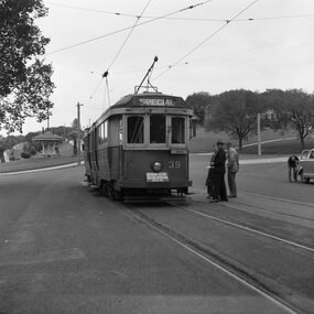
 Ballarat Tramway Museum
Negative - Set of 2, Geoff Grant, 2/04/1955 12:00:00 AM
Negative No. 265 and colour print made by colour laser printer (stored in folder ) of a head on shot of No. 39 in front of the Geelong depot, by Geoff Grant on 2/4/1955 while on an Australian Electric Traction Association tour. Other trams in view are 1 and 17. .1 - Copy large format print from Lloyd Rogers collection via Robert Green 2/2014. Added 4-4-2019 - 2 copies added. Original negative scanned at hi res 18/5/2020 and image updated.On small copy ex Robert Green in ink "Geelong car shed, 2-4-1955, ARHS Neg" On large print in pencil "Geelong 2-4-1955"trams, tramways, geelong, aeta, depot, tram 39 tram 1 tram 17 -
 Ballarat Tramway Museum
Photograph - Black & White Photograph/s - set of 2, Geoff Grant, 8/01/1956 12:00:00 AM
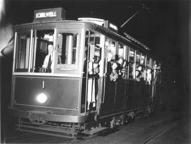
Black & White Photograph of Geelong No. 1 with destination "Chilwell", taken at night, on last day of operation of the Chilwell and East - West line of Geelong Trams, 8/1/1956. Tram has "PAY AS YOU ENTER" board on front entry of tram. See also Reg Item 5898i6 - photo by Keith Kings for a similar or same photograph. .1 - Copy large format print from Lloyd Rogers collection via Robert Green 2/2014. Added 4-4-2019Stamped on rear, btm rh corner "Geoff Grant 8 Jan. 1956 Victoria" .1 - in ink in bottom left hand corner "Last day of operation of Chilwell line 8th Jan 1956"trams, tramways, geelong, chilwell, closure , tram 1 -
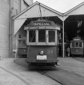
 Ballarat Tramway Museum
Photograph - Black & White Photograph/s - set of 2, Geoff Grant, 2/04/1955 12:00:00 AM
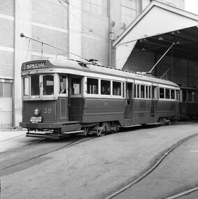
Black & White photo of SECV Geelong No. 39 standing outside Geelong depot shed, prior to running in AETA tour on 2/4/1955. Destination showing "SPECIAL" and AETA tour board on front bumper of tram. N261 envelope - "One man operation car No. 39 standing outside depot. AETA Tour, Geelong 2nd April 1955" .1 - Copy large format print from Lloyd Rogers collection via Robert Green 2/2014. Added 4-4-2019 Original negative scanned at hi res 18/5/2020 and image updated.On rear in typed paper "Car no 39 one man operation car standing at Geelong depot for AETA tour. April 2 1955" and "Geoff Grant" stamp on btm rh corner. .1 - In ink in bottom left hand corner - "Geelong Depot - One man car 2-4-1955"trams, tramways, geelong, aeta, tours , tram 39 -
 Ballarat Tramway Museum
Photograph - Black & White Photograph/s - set of 3, Geoff Grant, 8/01/1956 12:00:00 AM
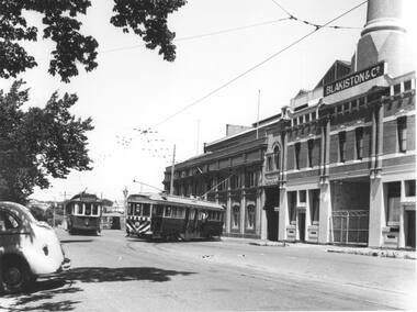
Yields information about the appearance of Geelong's trams in particular ex Melbourne J class trams after receipt in Geelong. This tram later became Ballarat No. 11.Black and white print from a Geoff Grant negative of a Geelong bogie tram entering Corio Terrace from the Geelong depot on 8/1/1956, while Pengelley 19 waits in the siding. The bogie tram (37) has destination of "Special", 19 - "Chilwell". Has the Geelong SEC depot/powerhouse building in the background with part of the Blakistons' sign visible. Photo used in Trolley Wire, Feb. 1999, page 11, article on Geelong tramways. Pencil marks on the rear of the photo indicate proposed used of the photo in the article. 2472.2 - As above but with the rear of the motor vehicle edited from the photograph. Produced by William Scott for his book, 2008. Two copies. Added 21/7/2009. 2472.3 - large format print from Lloyd Rogers collection via Robert Green 2/2014. Added 4-4-20192472 - On rear in red ink "Geelong Depot 8-1-56" in top left hand corner and in bottom left hand corner "G.A. Grant" 2472.1 - on rear of copy 1 in ink in top left hand corner "40) Geelong 8.1.1956 / G. Grant pic / modified image (background only). Last day of Chilwell Route in 1st closures. Single truck car being changed over about mid afternoon for a bogie car to cater for increased traffic / Cars 19 and 37." copy 2 - "Geelong 8.1.1956 / G. Grant pic / cars 19 & 37." copy 3 - "Geelong tram depot / 8th Jan 1956"trams, tramways, geelong, geelong depot, corio terrace, chilwell, tram 19, tram 37 -
 Bendigo Historical Society Inc.
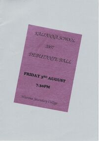
Document - PETER ELLIS COLLECTION: KALIANNA SCHOOL DEBUTANTE BALL, 3rd August, 2007
Program for the Kalianna School Debutante Ball held on Friday 3rd August 2007 at the Weerona Secondary College. Program is light grey with a purple sticker on an angle with the name on it. On white paper on the inside is the names of the debutantes and their partners and who they were presented to, Master of Ceremonies & Deb Set Co-ordinator, Chaperones, Compares, Music by Emu Creek Band, Flower Girl and Page Boy. Pasted on the back is a matching grey card thanking businesses and people who helped. Names are: Cr Kevin Gibbons, Debbie Gibbons, Lindy & William Lupo, Alison & Geoff Byron, Leon Scott, Debbie Price, Peter Burch, Cherryl Fyffe, Leon Scott, Emu Creek Band, Rebecca Nelson, Caleb Richardson, Charmaine Scown, Alicia Owen, Jessica Brereton, Nikita Riordan, Laura Semmens, Rebecca Apps, Chloe Gruber, Lauren Hawken, Amanda Anderson, Victoria Jelbart, Rachell Sutherland, Amy Roberts, Sally McMurtrie, Chevonne Strauch, Ben Holmes, Dean Snelson, Zac Flint, Tamati Poindestre, Brandon Kelly, Paul Drinkell, Adrian Brown, Chris Oojges, David Boyce, Josh Rosewall, Michael Semmens, John Wiktorek, Kane Wojcicki, Matthew Mitchell, Hairem Scarem, Grant Rule Menswear, Sean Walsh Photography, Mary Smith (Plant Exhibits), Anne Hastings (Deb Ball Seamstress), Debbie Price, Tracey Wojcicki, Glenys Jelbart, Pam Holmes, Rae Hall, Samantha Wearne, Kylie Salter, Cathy Brew, Judy Richards, Aileen Gilbee, Marie Loch, Noel & Lorna Thomas, Ron & Janette Moss, Tracey & Peter Wojcicki, Val & Neil Cartledge, Warwick Strauch, Kevin Salter, Grant King, Kay Tamblyn and Christine Smith.Weerona Secondary Collegeentertainment, dance, ball, peter ellis collection, kalianna school, weerona secondary college, cr kevin gibbons, debbie gibbons, lindy & william lupo, alison & geoff byron, leon scott, debbie price, peter burch, cherryl fyffe, leon scott, emu creek band, rebecca nelson, caleb richardson, charmaine scown, alicia owen, jessica brereton, nikita riordan, laura semmens, rebecca apps, chloe gruber, lauren hawken, amanda anderson, victoria jelbart, rachell sutherland, amy roberts, sally mcmurtrie, chevonne strauch, ben holmes, dean snelson, zac flint, tamati poindestre, brandon kelly, paul drinkell, adrian brown, chris oojges, david boyce, josh rosewall, michael semmens, john wiktorek, kane wojcicki, matthew mitchell, hairem scarem, grant rule menswear, sean walsh photography, mary smith (plant exhibits), anne hastings (deb ball seamstress), debbie price, tracey wojcicki, glenys jelbart, pam holmes, rae hall, samantha wearne, kylie salter, cathy brew, judy richards, aileen gilbee, marie loch, noel & lorna thomas, ron & janette moss, tracey & peter wojcicki, val & neil cartledge, warwick strauch, kevin salter, grant king, kay tamblyn, christine smith -
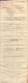 Bendigo Historical Society Inc.
Document - JOHANSON COLLECTION: GRANT BY PURCHASE WILLIAM ROBERTS
... COLLECTION: GRANT BY PURCHASE WILLIAM ROBERTS ...Legal document. On front: Dated 17th December 1855. Ac1 R1 P 1. ( acres, roods, perches ) Grant by purchase to William Roberts. In pencil Allot 7 of Sec 12. Inside: 'Victoria - Township Lot. Grantee W. Roberts. Document details purchase of land by above William Roberts of Heathcote, for the sum of two pounds, 12 shillings. Allotment 7, section 12, Township of Heathcote. Land sold as Lot 14. Dated 30 July 1855. Signed by C.W. Hotham ( Sir Charles Hotham ) Property is now 42 Beauchamp Street, Heathcote ( Landata research, 28.3.2017, https://www.landata.vic.gov.au/tpc_confirm_map.aspx?pfi=45257085 )heathcote, land sale, william roberts -
 Bendigo Historical Society Inc.
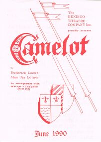
Programme - THE BENDIGO THEATRE COMPANY ''CAMELOT''
The Bendigo Theatre Company Present ''Camelot'' by Frederick Loewe - Alan Jay Lerner - June 1990 Directed by Carol McKenzie-Grose at J.B. Osborne Theatre Kangaroo Flat June 21st,22nd,23rd,28th,29th,30th 1990 at 8pm with a matinee on Sunday 24th at 2pm. Stage Manager: Jim Dunn - Wardrobe: Jill Fitzgerald - Choreographer: Viktoria Lee. Cast: Ken Dunn as Arthur - Sally Hyett as Guenevere - Michael Goss as Lancelot - Jack Paynting as Pellinore - Jim Watson as Merlyn - Viktoria Lee as Morgan Le Fey - Glenn Grose as Sir Dinadan - John Adams as Sir Sagromore - Grant Thomas as Sir Lionel - Shane Rofe as Sir Clarius - Robert Caldwell as Squire Dap - Kate McQueenie as Lady Sybil - Hilary Bottcher as Nimue - Elfi Willman as Ballad Singer - Brad Giri, Sean Hillman as Tom of Warwick - Sean Hillman as Juggler - Dancers: Kristen Tuddenham, Sasha Poole, Christine Fitzgerald, Harmony Davis, Kerry Schache.program, theatre, the bendigo theatre company -
 Bendigo Historical Society Inc.
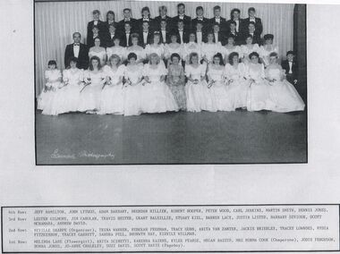
Photograph - PETER ELLIS COLLECTION: DEBUTANTE BALL
Black and white reproduction photograph. Debutante ball. 4th Row: Jeff Hamiliton, John Lythgo, Adam Barbary, Brendan Hillier, Robert Hooper, Peter Wood, Carl Jenkins, Martin Smith, Dennis Jones. 3rd Row: Lester Gilmore, Jim Carolan, Travis Hester, Grant Balsillie, Stuart Kiel, Darren Lacy, Justin Lister, Barnaby Seviour, Scott McNamara, Andrew David. 2nd Row: Neville Sharpe (Organiser), Trina Warren, Rebekah Freeman, Tracy Gunn, Anita Van Zanten, Jackie Brierley, Tracey Lowndes, Nydia FitzGibbon, Tracey Garrett, Sandra Pell, Bronwyn Day, Kirrily Willman. 1st Row: Melinda Lane (Flowergirl), Anita Scinetti, Karenna Kairns, Kylee Pearse, Megan Baxter, Mrs Norma Cook (Chaperone), Jodie Ferguson, Donna Jones, Jo-Anne Chalkley, Suzi Davis, Scott Davis (Pageboy).photo, group, debutante ball -
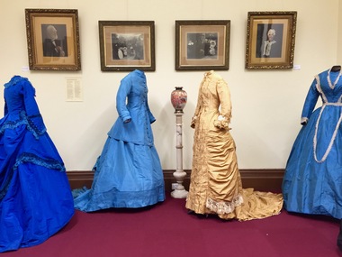 Kew Historical Society Inc
Photograph - Digital Photographs [Series], Robert Baker, Exhibition: Victorian Fashion, Kew Court House, 2016, 03/03/2016
From its beginnings in 1958, the Society has mounted exhibitions and/or displays, in early days in shop windows and in community spaces located in the Kew City Hall (later Kew Library), and since 2010 at the Kew Court House. Exhibitions typically coincided with the annual Kew Community Festival in March, but after 2013 evolved into three new exhibitions yearly at the Kew Court House. Smaller displays continue to be mounted in the Kew LibrarySeries of born digital images of an exhiition at the Kew Court House in 2016 of Victorian era costumes, largely drawn from the Coombs Collection of the Society. The mounting of the costumes was made possible by a City of Boroondara Strengthening Communities grant for 2015-16. Each of the costumes displayed here is separately catalogued on Victorian Collections.kew historical society - exhibitions, australian fashion - 19th century, coombs collection -
 Kew Historical Society Inc
Photograph - Series, Robert Baker, Exhibition of Victorian Fashion at the Villa Alba Museum, 00/08/2016
From its beginnings in 1958, the Society has mounted exhibitions and/or displays, in early days in shop windows and in community spaces located in the Kew City Hall (later Kew Library), and since 2010 at the Kew Court House. Exhibitions typically coincided with the annual Kew Community Festival in March, but after 2013 evolved into three new exhibitions yearly at the Kew Court House. Smaller displays continue to be mounted in the Kew Library. Series of born digital images of a lecture and an exhiition at the Villa Alba Museum in 2016 of Victorian era costumes, largely drawn from the Coombs Collection of the Society. The mounting of the costumes was made possible by a City of Boroondara Strengthening Communities grant for 2015-16. Most of the costumes displayed here are separately catalogued on Victorian Collections.kew historical society - exhibitions, villa alba museum, victorian fashion, fashion & design exhibition -
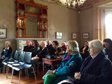
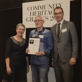 Kew Historical Society Inc
Photograph, National Library of Australia, Community Heritage Grant Awards Ceremony, 2017
Kew Historical Society was awarded a grant by the Library for a Significance Assessment in 2017-18. Preliminary workshops were held in Canberra at the Library, where the awards ceremony took place.Kew Historical Society Archivist receiving a Community Heritage Grant award on behalf of the Society at a ceremony in Canberra to conduct a Significance Assessment. kew historical society - awards, significance assessment -- national library of australia, robert baker - archivist - kew historical society inc -
Kew Historical Society Inc
Journal, Kew Historical Society, Newsletter No.102, March 2013
KHS Strategic Plan 2013-18 / Alex Wilson OAM p1-2, 4. Society Activities - Bendigo Bank Community Grant 2013; 2013 Kew Community Festival; Past meetings; Future meetings; Other Societies; State Library of Victoria / p3. KHS Collections Group / Robert Baker p4. Lost and found ['Mooroolbeek'; 'Clutha'] / Robert Baker p4. The Streets of Kew 1880-1890 / Andrew Frost p6-7. Nooks, crannies, and a pet magpie ['Glastonbury', 18 John Street] / Dione McIntyre p8. The Skinny Dog Hotel [Greyhound Hotel] / Robert Baker p9-10. Rosemary Louise Smart OAM / Dione McIntyre, Dorothy Benyei, Rae Nichols p10. Kewriosity [Louise Kahan windows, Bet Nachman Synagogue] / Alex Wilson OAM p11. 2013 Calendar / p12.Published quarterly since 1977, the newsletters of the Kew Historical Society contain significant research by members exploring relevant aspects of the Victorian and Australian Framework of Historical Themes. Frequently, articles on people, places and artefacts are the only source of information about an aspect of Kew, and Melbourne’s history.non-fictionKHS Strategic Plan 2013-18 / Alex Wilson OAM p1-2, 4. Society Activities - Bendigo Bank Community Grant 2013; 2013 Kew Community Festival; Past meetings; Future meetings; Other Societies; State Library of Victoria / p3. KHS Collections Group / Robert Baker p4. Lost and found ['Mooroolbeek'; 'Clutha'] / Robert Baker p4. The Streets of Kew 1880-1890 / Andrew Frost p6-7. Nooks, crannies, and a pet magpie ['Glastonbury', 18 John Street] / Dione McIntyre p8. The Skinny Dog Hotel [Greyhound Hotel] / Robert Baker p9-10. Rosemary Louise Smart OAM / Dione McIntyre, Dorothy Benyei, Rae Nichols p10. Kewriosity [Louise Kahan windows, Bet Nachman Synagogue] / Alex Wilson OAM p11. 2013 Calendar / p12. kew historical society (vic.) -- periodicals., kew historical society (vic.) -- newsletters, kew historical society (vic.) -- journals -
Kew Historical Society Inc
Journal, Kewriosity : November 1986
Kew faces [Bruce Rigby; Images of Kew] / p1. A gentle reminder about Kew's By-laws - Dogs / p1. Dates for November / p2. [Community] Notices / p2. Commentary [Streetworks are budget priority 1; New and new-style services] / Cr Joe Ormando, Mayor of Kew / p3. Profile: Cr Phyllis Tinney / p4. Kew's Community Bus [More jockeys needed] / p4. Kew's foster child [Foster Parent PLAN, Gaoussou Simpara] / p5. In Brief [Advisor for Premier Youth Theatre; Get fit for Summer] / p5. Children's Services update [Children’s Services Consultative Committee] / p5. 1987 Kew Festival [dates] / p5. Kew's champion rower [Michael McKay] / p6. DO CARE looking for volunteer visitors / p6. Kew Community House [Volunteers needed; November classes; Our garden] / p7. A fond farewell to Rev George Grant [East Kew Uniting Church] / p7. What's what in the playground [Alexandra Gardens; Reservoir Reserve; Victoria Park] / p7. [Kew Citizens'] Band news / p7 Citizen advocacy: a new way to protect the rights of people with disabilities in our community / p8. Footy news [Robert DiPierdomenico, Kew Football Club] / p8. Keeping you informed [Community Advice Bureau] / p8. Kew Nursing Mothers / p8.Kewriosity was a local newsletter combining Kew Council and community news. It was published between November 1983 and June 1994, replacing an earlier Kewriosity [broad] Sheet (1979-84). In producing Kewriosity, Council aimed to provide a range of interesting and informative articles covering its deliberations and decision making, together with items of general interest and importance to the Kew community and information not generally available through daily media outlets.non-fictionKew faces [Bruce Rigby; Images of Kew] / p1. A gentle reminder about Kew's By-laws - Dogs / p1. Dates for November / p2. [Community] Notices / p2. Commentary [Streetworks are budget priority 1; New and new-style services] / Cr Joe Ormando, Mayor of Kew / p3. Profile: Cr Phyllis Tinney / p4. Kew's Community Bus [More jockeys needed] / p4. Kew's foster child [Foster Parent PLAN, Gaoussou Simpara] / p5. In Brief [Advisor for Premier Youth Theatre; Get fit for Summer] / p5. Children's Services update [Children’s Services Consultative Committee] / p5. 1987 Kew Festival [dates] / p5. Kew's champion rower [Michael McKay] / p6. DO CARE looking for volunteer visitors / p6. Kew Community House [Volunteers needed; November classes; Our garden] / p7. A fond farewell to Rev George Grant [East Kew Uniting Church] / p7. What's what in the playground [Alexandra Gardens; Reservoir Reserve; Victoria Park] / p7. [Kew Citizens'] Band news / p7 Citizen advocacy: a new way to protect the rights of people with disabilities in our community / p8. Footy news [Robert DiPierdomenico, Kew Football Club] / p8. Keeping you informed [Community Advice Bureau] / p8. Kew Nursing Mothers / p8. publications -- city of kew (vic.), kewriosity, council newsletters, community newsletters -
Kew Historical Society Inc
Journal, Kew Historical Society, Newsletter No.144, September 2023
Elephants in Kew [Kew Library redevelopment] / David White p1. History News - 2023 Dickinson Lecture; Kew Court House [exhibition]; Additions to the Collection; New members; Grants & Sponsors / p3. Victorian Municipal Directories / Robert Baker p4. Michael Meszaros: Kew sculptor / Felicity Renowden p6. Chipperfield's Boathouse: 'The Moorings' and floating pontoon / Julie King p8. Wilfred Kent Hughes: scholar, sportsman, soldier, businessman, author, politician / John Torpey p10.Published quarterly since 1977, the newsletters of the Kew Historical Society contain significant research by members exploring relevant aspects of the Victorian and Australian Framework of Historical Themes. Frequently, articles on people, places and artefacts are the only source of information about an aspect of Kew, and Melbourne’s history.non-fictionElephants in Kew [Kew Library redevelopment] / David White p1. History News - 2023 Dickinson Lecture; Kew Court House [exhibition]; Additions to the Collection; New members; Grants & Sponsors / p3. Victorian Municipal Directories / Robert Baker p4. Michael Meszaros: Kew sculptor / Felicity Renowden p6. Chipperfield's Boathouse: 'The Moorings' and floating pontoon / Julie King p8. Wilfred Kent Hughes: scholar, sportsman, soldier, businessman, author, politician / John Torpey p10.kew historical society (vic.) -- periodicals., kew historical society (vic.) -- newsletters, kew historical society (vic.) -- journals -
Kew Historical Society Inc
Journal, Newsletter No.145, December 2023
The Henty Collection [Significance Assessment] / Robert Baker p1. History News - Tributes: Alison Virginia Kemp (1947–2023), Kay Cole JP (1930–2023), Jane Mayo Carolan 1949–2023) ; New Members / p3-4. As it happened 100 years ago [Burke Road Bridge, Kew Primary School, Wilfred Kent Hughes] / David White (ed) / p4. City of Boroondara Triennial Operational Grant 2023–6 / p4. Berma Sellars 'Bib' Stilwell: entrepreneur, businessman, racing driver / Julie King p5-6. The Jellis Affair: make of it what you will [sexual violence, Victorian legal system, Kew Court of Petty Sessions] / Suzanne McWha p7-8. St Andrew's College: Mont Victor Road / Felicity Renowden p9-10. Good Neighbour "Mickey": Memories of the Kew Railway / James Foley p.11. Membership and Donations / p12.Published quarterly since 1977, the newsletters of the Kew Historical Society contain significant research by members exploring relevant aspects of the Victorian and Australian Framework of Historical Themes. Frequently, articles on people, places and artefacts are the only source of information about an aspect of Kew, and Melbourne’s history.non-fictionThe Henty Collection [Significance Assessment] / Robert Baker p1. History News - Tributes: Alison Virginia Kemp (1947–2023), Kay Cole JP (1930–2023), Jane Mayo Carolan 1949–2023) ; New Members / p3-4. As it happened 100 years ago [Burke Road Bridge, Kew Primary School, Wilfred Kent Hughes] / David White (ed) / p4. City of Boroondara Triennial Operational Grant 2023–6 / p4. Berma Sellars 'Bib' Stilwell: entrepreneur, businessman, racing driver / Julie King p5-6. The Jellis Affair: make of it what you will [sexual violence, Victorian legal system, Kew Court of Petty Sessions] / Suzanne McWha p7-8. St Andrew's College: Mont Victor Road / Felicity Renowden p9-10. Good Neighbour "Mickey": Memories of the Kew Railway / James Foley p.11. Membership and Donations / p12.kew historical society (vic.) -- periodicals., kew historical society (vic.) -- newsletters, kew historical society (vic.) -- journals -
Kew Historical Society Inc
Journal, Kew Historical Society, Newsletter No.136, September 2021
Photograph Albums / Robert Baker p1. History News: Annual General Meeting; The Collection [new acquisitions]; 2021 Dickinson Lecture; Grants & Sponsors; Obituary - Prudence (Prue) Theresa McColl 1945-2021; Membership renewals / p3. Vernacular design: depression era tool chest / Robert Baker p4. Mid-century modern: 7 Hume Street / David White p6. Sammy the monkey and Lee the 'bulldog' / Suzanne McWha p7. Shooting as a sport / Brad Miles p8. The Four Seasons Window: a 125th anniversary gift / Felicity Renowden p9. An Edwardian dress / Robert Baker p11. Membership & Donations p12.Published quarterly since 1977, the newsletters of the Kew Historical Society contain significant research by members exploring relevant aspects of the Victorian and Australian Framework of Historical Themes. Frequently, articles on people, places and artefacts are the only source of information about an aspect of Kew, and Melbourne’s history.non-fictionPhotograph Albums / Robert Baker p1. History News: Annual General Meeting; The Collection [new acquisitions]; 2021 Dickinson Lecture; Grants & Sponsors; Obituary - Prudence (Prue) Theresa McColl 1945-2021; Membership renewals / p3. Vernacular design: depression era tool chest / Robert Baker p4. Mid-century modern: 7 Hume Street / David White p6. Sammy the monkey and Lee the 'bulldog' / Suzanne McWha p7. Shooting as a sport / Brad Miles p8. The Four Seasons Window: a 125th anniversary gift / Felicity Renowden p9. An Edwardian dress / Robert Baker p11. Membership & Donations p12.kew historical society (vic.) -- periodicals., kew historical society (vic.) -- newsletters, kew historical society (vic.) -- journals -
Kew Historical Society Inc
Journal, Kew Historical Society, Newsletter No.137, December 2021
Civic Ephemera / Robert Baker p1. Office Bearers / p2. History News: Acquisitions; Exhibitions; Grants & Sponsors; Tribute - Dorothy Johanna Benyei 1926-2021 / p3. Boroondara's Private Schools 1851-1951 / John Torpey p4. Alexandra Gardens: a chronological and horticultural survey / Desley Reid p6. Discoveries and Inventions [Trinity Grammar School] / Brad Miles p8. Another Alan Sumner Window [Carey Grammar] / Felicity Renowden p8. Victorian Collections / Robert Baker p8. The Sale of the Halfey Estate: Ordsall [Southesk] and Hermosa [Northesk] / David White p9. Centenary of thew Model Dairy / Robert Baker p11. Membership & Donations p12.Published quarterly since 1977, the newsletters of the Kew Historical Society contain significant research by members exploring relevant aspects of the Victorian and Australian Framework of Historical Themes. Frequently, articles on people, places and artefacts are the only source of information about an aspect of Kew, and Melbourne’s history.non-fictionCivic Ephemera / Robert Baker p1. Office Bearers / p2. History News: Acquisitions; Exhibitions; Grants & Sponsors; Tribute - Dorothy Johanna Benyei 1926-2021 / p3. Boroondara's Private Schools 1851-1951 / John Torpey p4. Alexandra Gardens: a chronological and horticultural survey / Desley Reid p6. Discoveries and Inventions [Trinity Grammar School] / Brad Miles p8. Another Alan Sumner Window [Carey Grammar] / Felicity Renowden p8. Victorian Collections / Robert Baker p8. The Sale of the Halfey Estate: Ordsall [Southesk] and Hermosa [Northesk] / David White p9. Centenary of thew Model Dairy / Robert Baker p11. Membership & Donations p12.kew historical society (vic.) -- periodicals., kew historical society (vic.) -- newsletters, kew historical society (vic.) -- journals -
Kew Historical Society Inc
Journal, Kew Historical Society, Newsletter No.138, March 2022
... and grants / Robert Baker p1. Office Bearers / p2. History News ...Exhibitions and grants / Robert Baker p1. Office Bearers / p2. History News: acquisitions; Victorian Collections; grants & sponsors; 2022 McIntyre Lecture / p3. Madford: a former mansion in Wellington Street / Robert Baker p4. Life on the River: Macauley's Boathouse / Julie King p5. What's A Quoll? - lively and appealing squirrel-like spotted cats / Suzanne McWha p7. In March 1922 / Trove p8. A Coronation Dress: from Westminster Abbey to Kew / Suzanne McWha & Felicity Renowden p9. The Yarra Yarra Jazz Band / Brad Miles p11. Membership & Donations p12.Published quarterly since 1977, the newsletters of the Kew Historical Society contain significant research by members exploring relevant aspects of the Victorian and Australian Framework of Historical Themes. Frequently, articles on people, places and artefacts are the only source of information about an aspect of Kew, and Melbourne’s history.non-fictionExhibitions and grants / Robert Baker p1. Office Bearers / p2. History News: acquisitions; Victorian Collections; grants & sponsors; 2022 McIntyre Lecture / p3. Madford: a former mansion in Wellington Street / Robert Baker p4. Life on the River: Macauley's Boathouse / Julie King p5. What's A Quoll? - lively and appealing squirrel-like spotted cats / Suzanne McWha p7. In March 1922 / Trove p8. A Coronation Dress: from Westminster Abbey to Kew / Suzanne McWha & Felicity Renowden p9. The Yarra Yarra Jazz Band / Brad Miles p11. Membership & Donations p12.kew historical society (vic.) -- periodicals., kew historical society (vic.) -- newsletters, kew historical society (vic.) -- journals -
Kew Historical Society Inc
Journal, Newsletter No.147, June 2024
Tram tracks in Boroondara [electrification of] / Robert Baker pp1-2. History News - Conservation [Henty Family Costume Collection, Community Heritage Grant application - National Library of Australia]; New Members; Donations to the Collection / p3. The Voyage of the John Bunyan / David White pp4-5. Family records: The diary of Mrs Henry Henty of Tarring / Suzanne McWha pp6-8. Sir Rupert 'Dick' Hamer AC KCMG ED / John Torpey pp8-9. As it happened 100 years ago [H.C.A. Harrison, Empire Day, Motor accident, Widening of High Street [Kew], Death of Cr [Sir] Henry [de Castres] Kellett, Bt / David White p.9. Branching out: the Coles family of Kew / Desley Reid pp.10-11. Membership and Donations / p12.Published quarterly since 1977, the newsletters of the Kew Historical Society contain significant research by members exploring relevant aspects of the Victorian and Australian Framework of Historical Themes. Frequently, articles on people, places and artefacts are the only source of information about an aspect of Kew, and Melbourne’s history.non-fictionTram tracks in Boroondara [electrification of] / Robert Baker pp1-2. History News - Conservation [Henty Family Costume Collection, Community Heritage Grant application - National Library of Australia]; New Members; Donations to the Collection / p3. The Voyage of the John Bunyan / David White pp4-5. Family records: The diary of Mrs Henry Henty of Tarring / Suzanne McWha pp6-8. Sir Rupert 'Dick' Hamer AC KCMG ED / John Torpey pp8-9. As it happened 100 years ago [H.C.A. Harrison, Empire Day, Motor accident, Widening of High Street [Kew], Death of Cr [Sir] Henry [de Castres] Kellett, Bt / David White p.9. Branching out: the Coles family of Kew / Desley Reid pp.10-11. Membership and Donations / p12.kew historical society (vic.) -- periodicals., kew historical society (vic.) -- newsletters, kew historical society (vic.) -- journals -
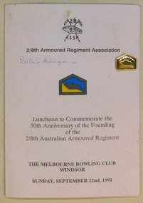 8th/13th Victorian Mounted Rifles Regimental Collection
Menu, September 1991
The 2/8th Armoured Regiment was raised in June 1941 under the command of Lieutenant Colonel W G Hopkins with officers and men selected from the wider AIF in Victoria. The regiment trained in newly arrived M3 General Grant tanks at Puckapunyal before moving north to Singleton, then the Wee Waa plains. The regiment sailed for New Guinea in April 1943 and carried out mobile defence to airfields at Port Moresby, Milne Bay, Dobadura and Popondetta. The regiment returned to Australia in February 1944 and disbanded as an armoured regiment and retrained as Nos 41, 42 and 43 Landing Craft Companies. They returned to the South West pacific serving at Bougainville, Balikpapan, Lae and Wewak. Captain Ken Menzies, son of Sir Robert and Dame Pattie Menzies served with the Regiment and consequently Dame Pattie became patron of the Regimental Association after the war.Rare document associated with an armoured regiment of WWII (1939-45) autographed by the patron Dame Pattie Menzies.Folded coloured card being Menu and Program for luncheon held at the Melbourne Bowling Club, Windsor, to commemorate the 50th Anniversary of the founding of the 2/8th Australian Armoured Regiment. Enamel lapel pin attached to front cover.Autograph of Patron on front cover Dame Pattie Menzies GBE "Pattie Menzies "; on back cover "Ian (Kilty) McKay / Lorna McKay" and "Pattie Menzies"2/8th armoured regiment, menzies pattie dame -
Kew Historical Society Inc
Journal, Kew Historical Society, Newsletter No.133, December 2020
... . Grants / Robert Baker p3. Agreement for Sale of Land at Parish ...Stories of Diversity / Robert Baker p1. An Uncommon Year / Judith Voce p3. Grants / Robert Baker p3. Agreement for Sale of Land at Parish of Boroondara / David White p4. Adeneny Avenue: an Arcadian landscape / Suzanne McWha p7. Stuart Tovey: Kew pioneer of modern high energy Physics / Desley Reid p11. Membership & Donations p12.Published quarterly since 1977, the newsletters of the Kew Historical Society contain significant research by members exploring relevant aspects of the Victorian and Australian Framework of Historical Themes. Frequently, articles on people, places and artefacts are the only source of information about an aspect of Kew, and Melbourne’s history.non-fictionStories of Diversity / Robert Baker p1. An Uncommon Year / Judith Voce p3. Grants / Robert Baker p3. Agreement for Sale of Land at Parish of Boroondara / David White p4. Adeneny Avenue: an Arcadian landscape / Suzanne McWha p7. Stuart Tovey: Kew pioneer of modern high energy Physics / Desley Reid p11. Membership & Donations p12.kew historical society (vic.) -- periodicals., kew historical society (vic.) -- newsletters, kew historical society (vic.) -- journals