Showing 216 items
matching shire of whittlesea
-
 Greensborough Historical Society
Map, Melbourne and Metropolitan Board of Works. Survey Division, MMBW, Yarra 2500 / 12.24. Plenty and Blue Lake, 1977_10
Melbourne and Metropolitan Board of Works. Yarra 2500 [base map]. 12-24, Municipalities of Whittlesea 239 and Diamond Valley 257. Shows street names, easement sizes, lot numbers, lodged plan numbers, names of prominent features, contour values, creek or river names. Watsonia Railway Station and environs. Prominent streets: Memorial Drive. Includes Plenty River and Blue Lake in the Plenty Gorge.MMBW Map in 1:2500 [scale] series. Cream parchment with green tape reinforcing on edges and punched holes on left edge.mmbw, melbourne and metropolitan board of works, shire of diamond valley, plenty - maps, blue lake -
 Greensborough Historical Society
Map, Melbourne and Metropolitan Board of Works. Survey Division, MMBW, Yarra 2500 / 12.23. Janefield and Kangaroo Point, 1977_10
Melbourne and Metropolitan Board of Works. Yarra 2500 [base map] 12-23, Municipalities of Whittlesea 239 and Diamond Valley 257. No streets marked on this map. Includes Plenty River, Kangaroo Point, Janefield Colony and Janefield Reserve.MMBW Map in 1:2500 [scale] series. Cream parchment with green tape reinforcing on edges and punched holes on left edge.mmbw, melbourne and metropolitan board of works, shire of diamond valley, plenty - maps -
 Greensborough Historical Society
Map, Melbourne and Metropolitan Board of Works. Survey Division, MMBW, Yarra 2500 / 13.22. Greensborough, Apollo Parkways, 1979_06
Melbourne and Metropolitan Board of Works. Yarra 2500 [base map] 13-22. Greensborough, Apollo Parkways. Parishes of Nillumbik 3310 and Keelbundora 2856. Municipalities of Diamond Valley 257 and Whittlesea 239. Prominent streets include: Plenty River Drive, Diamond Creek Road and Civic Drive. Includes Diamond Valley Civi Centre, Churinga, Janefield Colony Reserve and "proposed freeway" now Greensborough Highway (Bypass)MMBW Map in 1:2500 [scale] series. Cream parchment with green tape reinforcing on edges and punched holes on left edge.mmbw, melbourne and metropolitan board of works, shire of diamond valley, greensborough - maps, apollo parkways - maps -
 Greensborough Historical Society
Map, Melbourne and Metropolitan Board of Works. Survey Division, MMBW, Yarra 2500 / 13.23. Plenty, Happy Hollow, 1979_03
Melbourne and Metropolitan Board of Works. Yarra 2500 [base map] 13-23. Plenty / Happy Hollow. Parishes of Morang 3183, Nillumbik 3310 and Keelbundora 2856. Municipalities of Diamond Valley 257 and Whittlesea 239. Prominent streets include: McLaughlans Lane and Happy Hollow Drive. Includes Janefield Colony Reserve.MMBW Map in 1:2500 [scale] series. Cream parchment with green tape reinforcing on edges and punched holes on left edge.mmbw, melbourne and metropolitan board of works, shire of diamond valley, plenty - maps, happy hollow -
 Greensborough Historical Society
Map, Melbourne and Metropolitan Board of Works. Survey Division, MMBW, Yarra 2500 / 17.27. Central Hurstbridge, 1978_02
Melbourne and Metropolitan Board of Works. Yarra 2500 [base map] 17-27. Central Hurstbridge. Parish of Greensborough 2724, Municipalities of Diamond Valley 257, Eltham 238 and Whittlesea 239. Prominent streets include: Anzac Avenue and Hurstbridge-Arthurs Creek Road. MMBW Map in 1:2500 [scale] series. Cream parchment with green tape reinforcing on edges and punched holes on left edge.mmbw, melbourne and metropolitan board of works, shire of diamond valley, hurstbridge - maps -
 Greensborough Historical Society
Map, Melbourne and Metropolitan Board of Works. Survey Division, MMBW, Yarra 2500 / 11.22. Bundoora, 1979_01
Melbourne and Metropolitan Board of Works. Yarra 2500 [base map] 11-22. Bundoora. Parish of Keelbundoora 2856, Municipalities of Diamond Valley 257 and Whittlesea 239. Prominent streets include: Greenhills Road, Cabernet Crescent and Plenty Road. Includes Parade College (Christian Brothers) and "proposed future freeway" (now Metropolitan Ring Road)MMBW Map in 1:2500 [scale] series. Cream parchment with green tape reinforcing on edges and punched holes on left edge.mmbw, melbourne and metropolitan board of works, shire of diamond valley, bundoora - maps -
 Greensborough Historical Society
Map, Melbourne and Metropolitan Board of Works. Survey Division, MMBW, Yarra 2500 / 11.21. Bundoora, east of Plenty Road, 1979_01
Melbourne and Metropolitan Board of Works. Yarra 2500 [base map] 11-21. Bundoora, east of Plenty Road. Parish of Keelbundoora 2856, Municipalities of Diamond Valley 257, Preston 225 and Whittlesea 239. Prominent streets include: Grimshaw Street, Settlement Road and Plenty Road. Includes Yulong Park.MMBW Map in 1:2500 [scale] series. Cream parchment with green tape reinforcing on edges and punched holes on left edge.mmbw, melbourne and metropolitan board of works, shire of diamond valley, bundoora - maps -
 Greensborough Historical Society
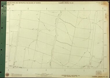
Map, Melbourne and Metropolitan Board of Works. Survey Division, MMBW, Yarra 2500 / 15.28. Yarrambat, 1977_10
Melbourne and Metropolitan Board of Works. Yarra 2500 [base map] 15-28. Yarrambat. Municipalities of Diamond Valley 257 and Whittlesea 239. Prominent streets include: Edward Henty Avenue, Charles Sturt Drive and Creighton Way. MMBW Map in 1:2500 [scale] series. Cream parchment with green tape reinforcing on edges and punched holes on left edge.mmbw, melbourne and metropolitan board of works, shire of diamond valley, yarrambat - maps -
 Greensborough Historical Society
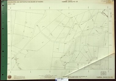
Map, Melbourne and Metropolitan Board of Works. Survey Division, MMBW, Yarra 2500 / 16.28. East of Hurstbridge, 1977_10
Melbourne and Metropolitan Board of Works. Yarra 2500 [base map] 16.28. East of Hurstbridge. Municipalities of Whittlesea 239, Eltham 238 and Diamond Valley 257. Prominent streets include: Boyds Road, Bannons Lane and Wattle Tree Road. MMBW Map in 1:2500 [scale] series. Cream parchment with green tape reinforcing on edges and punched holes on left edge.mmbw, melbourne and metropolitan board of works, shire of diamond valley -
 Greensborough Historical Society
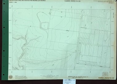
Map, Melbourne and Metropolitan Board of Works. Survey Division, MMBW, Yarra 2500 / 14.28. Yarrambat Park, 1977_09
Melbourne and Metropolitan Board of Works. Yarra 2500 [base map] 14.28. Yarrambat Park. Municipalities of Diamond Valley 257 and Whittlesea 239. Prominent streets include: Bannons Road and Yan Yean Road. Features include the Plenty River.MMBW Map in 1:2500 [scale] series. Cream parchment with green tape reinforcing on edges and punched holes on left edge.mmbw, melbourne and metropolitan board of works, shire of diamond valley, whttlesea, yarrambat - maps -
 Greensborough Historical Society
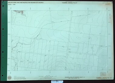
Map, Melbourne and Metropolitan Board of Works. Survey Division, MMBW, Yarra 2500 / 14.27. Yarrambat, Youngs Road, 1977_09
Melbourne and Metropolitan Board of Works. Yarra 2500 [base map] 14.27. Yarrambat, Youngs Road. Municipalities of Diamond Valley 257 and Whittlesea 239. Prominent streets include: Youngs Road, Ashley Road and Yan Yean Road. MMBW Map in 1:2500 [scale] series. Cream parchment with green tape reinforcing on edges and punched holes on left edge.mmbw, melbourne and metropolitan board of works, shire of diamond valley, whttlesea, yarrambat - maps -
 Greensborough Historical Society
Map, Melbourne and Metropolitan Board of Works. Survey Division, MMBW, Yarra 2500 / 13.24. Plenty, Memorial Drive, 1979_03
Melbourne and Metropolitan Board of Works. Yarra 2500 [base map] 13-24. Plenty, Memorial Drive. Parish of Morang 3183. Municipalities of Diamond Valley 257 and Whittlesea 239. Prominent streets include: Oatland Road, River Avenue and Memorial Drive. Includes Plenty River and SEC Transmission easement.MMBW Map in 1:2500 [scale] series. Cream parchment with green tape reinforcing on edges and punched holes on left edge.mmbw, melbourne and metropolitan board of works, shire of diamond valley, plenty - maps -
 Greensborough Historical Society
Map, Melbourne and Metropolitan Board of Works. Survey Division, MMBW, Yarra 2500 / 13.26. Yarrambat, Worns Lane, 1978_02
Melbourne and Metropolitan Board of Works. Yarra 2500 [base map] 13.26. Yarrambat, Worns Lane. Municipalities of Diamond Valley 257 and Whittlesea 239. Prominent streets include: Worns Road, North Oatlands Road and Licola Street. Features include Plenty River.MMBW Map in 1:2500 [scale] series. Cream parchment with green tape reinforcing on edges and punched holes on left edge.mmbw, melbourne and metropolitan board of works, shire of diamond valley, whttlesea, yarrambat - maps -
 Greensborough Historical Society
Map, Melbourne and Metropolitan Board of Works. Survey Division, MMBW, Yarra 2500 / 13.23. Plenty, Middle Gorge, 1978_04
Melbourne and Metropolitan Board of Works. Yarra 2500 [base map] 13-23. Plenty / Middle Gorge. Parish of Morang 3183. Municipalities of Diamond Valley 257 and Whittlesea 239. Prominent streets include: Gorge Road, Kurrak Road and Browns Lane. Features include the Plenty River and Plenty Gorge Park.MMBW Map in 1:2500 [scale] series. Cream parchment with green tape reinforcing on edges and punched holes on left edge.mmbw, melbourne and metropolitan board of works, shire of diamond valley, plenty - maps, plenty gorge park -
 Greensborough Historical Society
Map, Melbourne and Metropolitan Board of Works. Survey Division, MMBW, Yarra 2500 / 13.28. Mernda, Wilton Vale, 1977_08
Melbourne and Metropolitan Board of Works. Yarra 2500 [base map] 13.28. Mernda, Wilton Vale. Municipality of Diamond Valley 257 and Whittlesea 239. Prominent streets: Wilton Vale Road. Features include Yan Yean Pipe Track and SEC Transmission Lines. The abandoned rail line (old Whittlesea line) is in the top left corner.MMBW Map in 1:2500 [scale] series. Cream parchment with green tape reinforcing on edges and punched holes on left edge.mmbw, melbourne and metropolitan board of works, shire of diamond valley, mernda - maps -
 Greensborough Historical Society
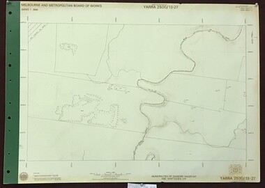
Map, Melbourne and Metropolitan Board of Works. Survey Division, MMBW, Yarra 2500 / 13.27. Morang wetlands, 1977_09
Melbourne and Metropolitan Board of Works. Yarra 2500 [base map] 13.27. Morang wetlands. Municipality of Diamond Valley 257 and Whittlesea 239. Features include the Plenty River and SEC Transmission Line easement. MMBW Map in 1:2500 [scale] series. Cream parchment with green tape reinforcing on edges and punched holes on left edge.mmbw, melbourne and metropolitan board of works, shire of diamond valley, morang - maps -
 Greensborough Historical Society
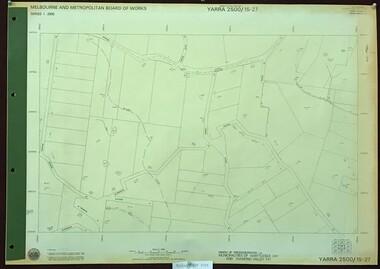
Map, Melbourne and Metropolitan Board of Works. Survey Division, MMBW, Yarra 2500 / 15.27. Yarrambat, De Fredricks Lane, 1977_10
Melbourne and Metropolitan Board of Works. Yarra 2500 [base map] 15.27. Yarrambat, De Fredricks Lane. Parish of Greensborough 2724. Municipality of Diamond Valley 257 and Whittlesea 239. Prominent streets include: De Fredricks Lane, Astons Road and Bannons Lane. Features include Scrubby Creek.MMBW Map in 1:2500 [scale] series. Cream parchment with green tape reinforcing on edges and punched holes on left edge.mmbw, melbourne and metropolitan board of works, shire of diamond valley, yarrambat - maps -
 Eltham District Historical Society Inc
Ledger, Eltham Road District. Assessment for the Year ending Oct. 14th, 1858, 1857c
The Eltham Roads Board was established in 1856. This is a unique significant record of early settlers in the Shire of Eltham. One of 6 early rate books. This is among the oldest items in the EDHS collection. An article in the Eltham and Whittlesea Shires Advertiser Friday 21 Nov 1941 Page 5 titled: District's Early History states: "The first rate book which is still in existence at the Shire Office is for the year ending October 14, 1858 and is probably the best record possible to indicate the development of the district. At the time properties were rated as follows: Cultivated land. 6d. per acre; pasture land, 1d. per acre: estimated annual value of buildings, etc., 6d in the (pound). The total amount of rate recorded for the year was (pounds)153/14/8. Properties were described as being situated at Lower Plenty, Yarra Yarra, Eltham, Lower Eltham, Kangaroo Ground, Yarra Flats, Diamond Creek and the Yarra."Ledger with printed columns: Number, Name of Occupier, Description, Where situated, Cultivated land, Pasture land, Estimated annual value of buildings, Rate, Remarks. Ledger filled out by hand with 152 entries (not alphabetically arranged). A number of blank pages are included. Copy re-bound in green hard leather look card by Arnall & Jackson Pty Ltd Brunswick, 1968 Inside cover includes a compliments slip taped to the cover from Arnall & Jackson Pty Ltd. with handwritten inscription: "Ian, I hope the hysterical society doesn't get historical about this". Organised 1968 I. Maynard Inside cover includes pasted printed note: RATE OF ASSESSMENT AS FOLLOWS: Cultivated land 6d per acre Pasture land 1 per acre Estimated Annual Value of Buildings, &c., 6d. in the Pound eltham roads board, rate book, rate payers, transaction, pioneers, settlers, 1858, assessment ledger, eltham road district, public records office victoria (prov), rate books, shire of eltham archives -
 Eltham District Historical Society Inc
Ledger, Eltham Road District. Assessment for the Year ending Oct. 14th, 1859, 1858c
The Eltham Roads Board was established in 1856. This ledger includes the signature of Road Board Secretary and Collector Wingrove, a significant person in Eltham's early history. This is a unique significant record of early settlers in the Shire of Eltham. One of 6 early rate books. This is among the oldest items in the EDHS collection. An article in the Eltham and Whittlesea Shires Advertiser Friday 21 Nov 1941 Page 5 titled: District's Early History states: "The first rate book which is still in existence at the Shire Office is for the year ending October 14, 1858 and is probably the best record possible to indicate the development of the district. At the time properties were rated as follows: Cultivated land. 6d. per acre; pasture land, 1d. per acre: estimated annual value of buildings, etc., 6d in the (pound). The total amount of rate recorded for the year was (pounds)153/14/8. Properties were described as being situated at Lower Plenty, Yarra Yarra, Eltham, Lower Eltham, Kangaroo Ground, Yarra Flats, Diamond Creek and the Yarra."Ledger with printed columns: Number, Name of Occupier, Description, Where situated, Cultivated land, Pasture land, Estimated annual value of buildings, Rate, Remarks, Arrears collected, excused, unoccupied, uncollected and amount actually collected. Ledger filled out by hand with 173 entries (not alphabetically arranged). A number of blank pages are included. Inside cover includes pasted printed note: RATE OF ASSESSMENT AS FOLLOWS: Cultivated land 6d per acre Pasture land 2d per acre Unalienated Pasture Land 8d per Acre Estimated Annual Value of Buildings, &c., 6d. in the Pound eltham roads board, rate book, rate payers, transaction, pioneers, settlers, wingrove, 1859, assessment ledger, eltham road district, public records office victoria (prov), rate books, shire of eltham archives -
 Eltham District Historical Society Inc
Ledger, Eltham Road District. Assessment for the Year ending Oct. 14th, 1860 (Version 1), 1859c
The Eltham Roads Board was established in 1856. This is a unique significant record of early settlers in the Shire of Eltham. One of 6 early rate books. This is among the oldest items in the EDHS collection. An article in the Eltham and Whittlesea Shires Advertiser Friday 21 Nov 1941 Page 5 titled: District's Early History states: "The first rate book which is still in existence at the Shire Office is for the year ending October 14, 1858 and is probably the best record possible to indicate the development of the district. At the time properties were rated as follows: Cultivated land. 6d. per acre; pasture land, 1d. per acre: estimated annual value of buildings, etc., 6d in the (pound). The total amount of rate recorded for the year was (pounds)153/14/8. Properties were described as being situated at Lower Plenty, Yarra Yarra, Eltham, Lower Eltham, Kangaroo Ground, Yarra Flats, Diamond Creek and the Yarra."Ledger with printed columns: Number, Name of Occupier, Description, Where situated, Cultivated land, Pasture land, Estimated annual value of buildings, Rate, Remarks, Arrears collected, excused, unoccupied, uncollected and amount actually collected. Ledger filled out by hand with 177 entries (not alphabetically arranged). A number of blank pages are included. Inside cover includes pasted printed note: RATE OF ASSESSMENT AS FOLLOWS: Cultivated land 6d per acre Pasture land 2d per acre Unalienated Pasture Land 8d per Acre Estimated Annual Value of Buildings, &c., 6d. in the Pound eltham roads board, rate book, rate payers, transaction, pioneers, settlers, wingrove, 1860, assessment ledger, eltham road district, public records office victoria (prov), rate books, shire of eltham archives -
 Eltham District Historical Society Inc
Ledger, Eltham Road District. Assessment for the Year ending Oct. 14th, 1860 (Version 2), 1859c
The Eltham Roads Board was established in 1856. This is a unique significant record of early settlers in the Shire of Eltham. One of 6 early rate books. This is among the oldest items in the EDHS collection. An article in the Eltham and Whittlesea Shires Advertiser Friday 21 Nov 1941 Page 5 titled: District's Early History states: "The first rate book which is still in existence at the Shire Office is for the year ending October 14, 1858 and is probably the best record possible to indicate the development of the district. At the time properties were rated as follows: Cultivated land. 6d. per acre; pasture land, 1d. per acre: estimated annual value of buildings, etc., 6d in the (pound). The total amount of rate recorded for the year was (pounds)153/14/8. Properties were described as being situated at Lower Plenty, Yarra Yarra, Eltham, Lower Eltham, Kangaroo Ground, Yarra Flats, Diamond Creek and the Yarra."Ledger with printed columns: Number, Name of Occupier, Description, Where situated, Cultivated land, Pasture land, Estimated annual value of buildings, Rate, Remarks, Arrears collected, excused, unoccupied, uncollected and amount actually collected. Ledger filled out by hand with 177 entries (not alphabetically arranged). A number of blank pages are included. This version was slight changes to version one. Inside cover includes pasted printed note: RATE OF ASSESSMENT AS FOLLOWS: Cultivated land 6d per acre Pasture land 2d per acre Unalienated Pasture Land 8d per Acre Estimated Annual Value of Buildings, &c., 6d. in the Pound eltham roads board, rate book, rate payers, transaction, pioneers, settlers, 1860, assessment ledger, eltham road district, public records office victoria (prov), rate books, shire of eltham archives -
 Eltham District Historical Society Inc
Ledger, Eltham Road District. Assessment for the Year ending Oct. 14th, 1861, 1860c
The Eltham Roads Board was established in 1856. This is a unique significant record of early settlers in the Shire of Eltham. One of 6 early rate books. This is among the oldest items in the EDHS collection. An article in the Eltham and Whittlesea Shires Advertiser Friday 21 Nov 1941 Page 5 titled: District's Early History states: "The first rate book which is still in existence at the Shire Office is for the year ending October 14, 1858 and is probably the best record possible to indicate the development of the district. At the time properties were rated as follows: Cultivated land. 6d. per acre; pasture land, 1d. per acre: estimated annual value of buildings, etc., 6d in the (pound). The total amount of rate recorded for the year was (pounds)153/14/8. Properties were described as being situated at Lower Plenty, Yarra Yarra, Eltham, Lower Eltham, Kangaroo Ground, Yarra Flats, Diamond Creek and the Yarra."Ledger with printed columns: Number, Name of Occupier, Description, Where situated, Cultivated land, Pasture land, Estimated annual value of buildings, Rate, Remarks, Arrears collected, excused, unoccupied, uncollected and amount actually collected. Ledger filled out by hand with 185 entries (not alphabetically arranged) and summary section. A number of blank pages are included. Inside cover includes pasted printed note: RATE OF ASSESSMENT AS FOLLOWS: Cultivated land 6d per acre Pasture land 2d per acre Unalienated Pasture Land 8d per Acre Estimated Annual Value of Buildings, &c., 6d. in the Pound eltham roads board, rate book, rate payers, transaction, pioneers, settlers, 1861, assessment ledger, eltham road district, public records office victoria (prov), rate books, shire of eltham archives -
 Eltham District Historical Society Inc
Ledger, Eltham Road District. Assessment for the Year ending Oct. 14th, 1862, 1861c
The Eltham Roads Board was established in 1856. This is a unique significant record of early settlers in the Shire of Eltham. One of 6 early rate books. This is among the oldest items in the EDHS collection. An article in the Eltham and Whittlesea Shires Advertiser Friday 21 Nov 1941 Page 5 titled: District's Early History states: "The first rate book which is still in existence at the Shire Office is for the year ending October 14, 1858 and is probably the best record possible to indicate the development of the district. At the time properties were rated as follows: Cultivated land. 6d. per acre; pasture land, 1d. per acre: estimated annual value of buildings, etc., 6d in the (pound). The total amount of rate recorded for the year was (pounds)153/14/8. Properties were described as being situated at Lower Plenty, Yarra Yarra, Eltham, Lower Eltham, Kangaroo Ground, Yarra Flats, Diamond Creek and the Yarra."Ledger with printed columns: Number, Name of Occupier, Description, Where situated, Cultivated land, Pasture land, Estimated annual value of buildings, Rate, Remarks, Arrears collected, excused, unoccupied, uncollected and amount actually collected. Ledger filled out by hand with 184 entries (not alphabetically arranged) and summary section. A number of blank pages are included. Inside cover includes pasted printed note: RATE OF ASSESSMENT AS FOLLOWS: Cultivated land 6d per acre Pasture land 1/2d per acre Unalienated Pasture Land 1/28 per Acre Estimated Annual Value of Buildings, &c., 6d. in the Pound eltham roads board, rate book, rate payers, transaction, pioneers, settlers, 1862, assessment ledger, eltham road district, public records office victoria (prov), rate books, shire of eltham archives -
 Eltham District Historical Society Inc
Ledger, Eltham Road District. Assessment for the Year ending Oct. 14th, 1863, 1862c
The Eltham Roads Board was established in 1856. This is a unique significant record of early settlers in the Shire of Eltham. One of 6 early rate books. This is among the oldest items in the EDHS collection. An article in the Eltham and Whittlesea Shires Advertiser Friday 21 Nov 1941 Page 5 titled: District's Early History states: "The first rate book which is still in existence at the Shire Office is for the year ending October 14, 1858 and is probably the best record possible to indicate the development of the district. At the time properties were rated as follows: Cultivated land. 6d. per acre; pasture land, 1d. per acre: estimated annual value of buildings, etc., 6d in the (pound). The total amount of rate recorded for the year was (pounds)153/14/8. Properties were described as being situated at Lower Plenty, Yarra Yarra, Eltham, Lower Eltham, Kangaroo Ground, Yarra Flats, Diamond Creek and the Yarra."Ledger with printed columns: Number, Name of Occupier, Description, Where situated, Cultivated land, Pasture land, Estimated annual value of buildings, Rate, Remarks, Arrears collected, excused, unoccupied, uncollected and amount actually collected. Ledger filled out by hand with 181 entries (not alphabetically arranged) and summary section. A number of blank pages are included. Inside cover includes pasted printed note: RATE OF ASSESSMENT AS FOLLOWS: Cultivated land 6d per acre Pasture land 1/2d per acre Unalienated Pasture Land 1/28 per Acre Estimated Annual Value of Buildings, &c., 6d. in the Pound eltham roads board, rate book, rate payers, transaction, pioneers, settlers, 1863, assessment ledger, eltham road district, public records office victoria (prov), rate books, shire of eltham archives -
 Eltham District Historical Society Inc
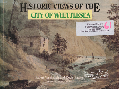
Book, Robert Wuchatsch 1950- et al, Historic views of the City of Whittlesea / Robert Wuchatsch and Gwen Hawke, 1988
... whittlesea shire... Wuchatsch, G. Hawke. 13/12/89. whittlesea shire Robert Wuchatsch ...Paperback; ix, 119 p. : chiefly ill. (some col.), 1 map, ports. ; 19 x 25 cm.ISBN 0958866333 [written on title page] To Eltham Historical Society, with our compliments and best regards - Whittlesea Historical Society - [signed] Robert Wuchatsch, G. Hawke. 13/12/89.whittlesea shire -
 Eltham District Historical Society Inc
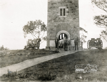
Photograph, Memorial Tower, Kangaroo Ground c.1934, 1934c
Sepia photograph of Joyce McMahon and 'Tiny' Carroll at the War Memorial Tower, Kangaroo Ground c.1934. The guns were installed in 1934 and removed in 1942. Taken in the early 1930s, the photograph ... shows the Kangaroo Ground Tower of Remembance with Joyce McMahon, daughter-in-law of Mr. P. J.McMahon, the then Shire of Eltham Secretary, her horse and a very tall person patting the horse. He is ex-serviceman W. "Tiny" Caroll who was the council's caretaker of the surrounding War Memorial Park. He lived in the stone cottage which still stands in the park. "Tiny" is seen as the fictional character "Tiny Bourke" who, in author Alan Marshall's book "This is the Grass", "was a giant of a man, well over six feet high, with huge hands that completely encircled the cup of tea". The bronze casting, which shows the 79 names of those who paid the "supremen sacrifice" in World War 1 (1914-1918), was erecfed above the entrance to the Tower in September, 1930. The Monterey cypress trees which now form the windbreak around the park's fenceline, were just knee high in this photograph. They were planted in August 1926, with all the plantings paid for, and done, by the public as the Tower was being erected. The two field guns have been identified as of German origin, Krupp 77 mm calibre captured on October 4, 1918 at Geneve, France. They were removed in 1943/44 as a wartime requirement of the Australian Govenment. A public notice dated October 16, 1926 by Cr. H Rutter, Chairman of the Eltham Soldiers War Memorial League stated: "On the summit of that central and conspicuous landmark, Garden Hill, there is being erected a massive memorial tower which will, for all time, remind every passerby of the part played by the men of the Shire of Eltham in the Great War. The work has been undertaken by the people of the Shire a a tribute of love and admiration for those who were known and dear to use in the days of their youth and early manhood, who went out from amongst us, never to return, and whose self-sacrifice has made us, each and all, thier ever-lasting debtors" Harry Gilham, Eltham District Historical Society Kangaroo Ground Tower of Remembrance, A Journey in Time: a column about Nillumbik's history, Nillumbik Mail, 9th August, 2000 Since that research the following has been sourced from Eltham and Whittlesea Shires Advertiser and Diamond Creek Valley Advocate, April 8, 1921, p. 3 Retrieved April 25, 2020, from http://nla.gov.au/nla.news-article57639687 Eltham Shire Council From Town Clerk, Melbourne, stating that a light machine-gun captured by the 22nd battalion, A.I.F. at La Motte Farm, near Beaurvoir, on Oct. 3rd, 1918, during the operations which won the Beauvoir line and completed the smashing of the great Hindenburg defence-system, has been alloted to the Shire of Eltham. - On the motion of Crs Hubbard and Smedley, it was decided to have the gun placed in the Memorial Park. Sepia Photographgarden hill, gun, joyce mcmahon, kangaroo ground, memorial tower, shire of eltham war memorial tower, tiny carroll, war memorials, war trophy, william carroll -
 Eltham District Historical Society Inc
Photograph, Monash Bridge, Arthurs Creek Road, Hurstbridge, Eltham Heritage Tour, 24 May 1992, 24/05/1992
ELTHAM HERITAGE TOUR The Society excursion on 24th May 1992 was arranged by David Bick, leader of the team carrying out the Shire's heritage study. David selected a number of sites or buildings identified in the study, some of them lesser known components of the Shire's heritage. The tour commenced at the Eltham Shire Office at 10.00 am. Travel was by private car and mini-bus with stops at about twelve locations for commentary by David.It included a short walk in Hurstbridge and lunch at Kinglake. Highlights of the tour included: - 10 am Leave from Shire Offices - 3 Important Trees - A Physical Link to Eltham's First Settlers - Toorak Mansion Gates - A Surviving Farm House - An Intact Circa 1900 Main Street - First Settlers - Gold Miners, and Timber-getters - An Early Hotel - A Pioneering Homestead - Changing Eltham Shire - 20th Century - 4 pm Afternoon Tea and Finish Tour Extract from ELTHAM CULTURAL HERITAGE TOUR (Newsletter No. 85, July 1992, by Bettina Woodburn) "On the Arthurs Creek Road is a bridge designed by Monash, which we admired before walking across the little park with a mud-brick and timber shelter, to the Hurst family graveyard. There are two marked graves, one, Henry who was shot by Burke the bushranger and a cairn has a plaque listing others buried here from 1866 onwards. Burke was captured and tied to the wheel of a dray under the eucalypt near the waterhose/standpipe. Close by the kindergarten, at this place are three trees on the National Trust Register, a Canary Island pine, a Canadian cedar and probably a spruce. Radiata pines and a thick bolled peppercorn surround the little cemetery. Continuing along Main Street we notice elm trees planted as a war memorial, then on the left a 1930 timber house, a 1910 store and residence, resplendent with wrought iron trim, a double fronted Hardware Store and cypresses on the back alignment of a new vacant block. On the right side of the street is a less interesting attempt at an 'in character' shop. Further on are more early homes, one tucked away at the rear with two tall palms by the front steps. Another curiosity is a rounded veranda corner and there are more galvanised iron sheds or garages, before a mud-brick Dentist's Surgery. Beyond the round-a-about is St Peters Church, of mud-brick construction shared by Catholic and Anglican parishioners, overlooking the river flood plain. Leaving Hurstbridge on the Kinglake Road, we ate our picnic lunch beside the communication tower and enjoyed views of Melbourne, Yan Yean Reservoir and the distant Dandenongs beyond the spreading suburbs. Next we drove to the North West boundary of the Shire at Masons Falls Road towards Whittlesea. On the way to the North East Boundary we passed St Peters, a yellow wooden Church with a Tudor Archway; built in the early 1920's in the style of the 1860's. From the Healesville-Kinglake road the rolling hills had European aspects, the hedged fields and chestnut trees. Then it was back down the Hurstbridge Road through 'Aussie' bush of towering gums, with bracken and scrubby understorey, the Kinglake National Park, before more open country with deciduous trees planted in line, and a creek lined with willows."Record of the Society's history and activities and highlighting various aspects of the Heritage Study undertaken by David Bick used to create the future heritage overlay for the Shire of Eltham and later Nillumbik Shire.Roll of 35mm colour negative film, 4 stripsKodak Gold 100 5095shire of eltham historical society, activities, heritage tour, hurstbridge, monash bridge, arthurs creek road -
 Eltham District Historical Society Inc
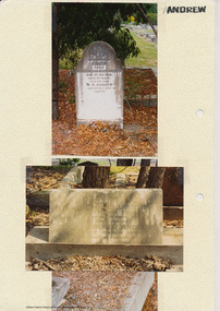
Folder, Andrew
James Andrew Kangaroo Ground, 1870 "James Andrew, Whittlesea, born in East Palford, Devonshire, England, in 1827, arrived in Adelaide in February 1850 per ship Lady McCaughton and almost immediately sailed in a coasting vessel to Melbourne, where the first work he undertook was clearing earth from a stone quarry in Collingwood. He next carried stones for masons engaged in building the Bishop’s Palace, and then was employed in Cambellfield mowing hay. He was at Saltwater River on Black Thursday, and afterwards took a little farm at Darebin Creek, remaining there for four years. He went up to Kangaroo Ground in 1859 and lived there until he bought his present property at Whittlesea, a farm of between 300 and 400 acres. He has been twice married, and had a family of six children." "Andrew, W. B. Eltham, is a native of England, born in 1822. Coming out to Australia in 1842, he lived in Brighton, Victoria for fifteen years, when he re-visited England for a year. Returning to Victoria fourteen or fifteen years ago, he commenced storekeeping at Eltham, where he has carried on that business ever since. Mr Andrew has always taken a lively interest in the public affairs of town and district” from "Victoria and its Metropolis: Past and Present" written in 1888 by Alexander Sutherland. Chapter 19, "The Upper Yarra District" pages [402] - 415. Includes descriptions of some townships and short biographies of local residents. Page 405 Folder of information on James Andrew, Trustee Kangaroo Ground Cemetery, Kangaroo Ground 1870 William Bravery Andrew, Eltham, 1870s-1880s Ernest James Andrew, Eltham, Eltham Shire Councillor, 1920s-1950 and Ellen Matilda Brown Andrewjames andrew, pioneer, kangaroo ground, ernest james andrew, william bravery andrew, ellen andrew, eltham cemetery, biography, ellen harper andrew (nee clarke), ellen matilda andrew (nee brown), eltham war memorial gate, eltham war memorial trust -
 Eltham District Historical Society Inc
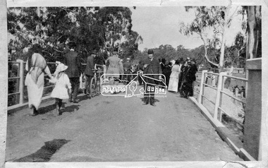
Photograph, Hurstbridge - Cr. Price crossing New Bridge (Opening Day), 1917
Eltham Shire Councillor Albert Price joined over 500 spectators for the official opening of the new re-inforced concrete bridge across the Diamond Creek at Hurstbridge. Eltham Shire shared the cost of the construction of the bridge with Heidelberg and Whittlesea Shires.This photo forms part of a collection of photographs gathered by the Shire of Eltham for their centenary project book, "Pioneers and Painters: 100 years of the Shire of Eltham" by Alan Marshall (1971). The collection of over 500 images is held in partnership between Eltham District Historical Society and Yarra Plenty Regional Library (Eltham Library) and is now formally known as 'The Shire of Eltham Pioneers Photograph Collection.' It is significant in being the first community sourced collection representing the places and people of the Shire's first one hundred years.Digital imagesepp, shire of eltham pioneers photograph collection, diamond creek, hurstbridge, wattle glen, bridge, councilor price, opening day, diamond creek (river) -
 Eltham District Historical Society Inc
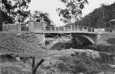
Negative - Photograph, New bridge at Hurstbridge, 1917
The newly constructed re-inforced concrete arched bridge across the Diamond Creek at Hurstbridge designed by John Monash. Eltham Shire shared the cost of the construction of the bridge with Heidelberg and Whittlesea Shires. The bridge was officially opened on 3rd November 1917. Part of a slide show presentation "Bridges & Waterways of the Shire" by Russell Yeoman to the 13 September 1989 Society meeting. The presentation included slides of historic photos from the Shire of Eltham Pioneers collections as well as several recent views.This photo forms part of a collection of photographs gathered by the Shire of Eltham for their centenary project book, "Pioneers and Painters: 100 years of the Shire of Eltham" by Alan Marshall (1971). The collection of over 500 images is held in partnership between Eltham District Historical Society and Yarra Plenty Regional Library (Eltham Library) and is now formally known as 'The Shire of Eltham Pioneers Photograph Collection.' It is significant in being the first community sourced collection representing the places and people of the Shire's first one hundred years.Digital image 4 x 5 inch B&W Negshire of eltham pioneers photograph collection, hurstbridge, bridge, 1917, diamond creek (creek), monash bridge