Showing 14001 items
matching snowy-river-bridge
-
 Federation University Historical Collection
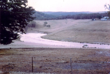
Photograph - Colour, Leigh River near Garibaldi Bridge
The Leigh River is a major tributary and catchment of the Barwon River. Fed by the Yarrowee River that rises near Ballarat, the Yarrowee reaches its confluence to form the Leigh in the vicinity of Cambrian Hill and Golden Plains Shire. The Leigh River rises below Mount Mercer and flows generally south, joined by three minor tributaries before reaching its confluence with the Barwon River, southeast of the central business district of Inverleigh. The river descends 265 metres (869 ft) over its 61-kilometre (38 mi) course. (https://en.wikipedia.org/wiki/Leigh_River_(Victoria)Relates to historical information about flooding of the Leigh River in 1933. Relevant to the history of Garibaldi and Durham Lead.A number of colour photographs showing the Leigh River between Garibaldi and Durham Lead, Victoria, .1 - .3) photographs of the Leigh River in flood .4 - .18) general photos of the Leigh River and surrounding countryside .19) broad angle photograph of the Leigh River and surrounding countryside leigh river, garibaldi, garibaldi bridge, durham lead, vincent family -
 Greensborough Historical Society
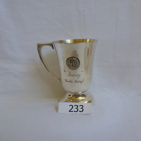
Trophy, Snowy - with thanks Darryl, 1975c
Presented to Alan (Snowy) Partington who trained Darryl Henderson in athletics. The 1975c date was supplied by Gary Partington on 13/7/2017.Silver presentation cup with handle. Has a medallion with CUB embossed on it.Engraved: "To Snowy, thanks, Darryl"alan partington, athletics, coaching -
 Lakes Entrance Historical Society
Postcard - Snowy River at Buchan, Rose Series P531, 1970 c
Black and white postcard of the Icicles a stalectite formation in the Buchan Caves 05305.1 Photo by Bulmer Donor Max Davenport 16 March 2019Black and white postcard of the peaceful Snowy River near Buchan VictoriaA Glimpse of the Snowy River near Buchan Vicwaterways -
 Ballarat Heritage Services
Painting, Clare Gervasoni, Old Bridge over the Woady Yallock River, 26/03/2023
Colour photographs of an old timber topped bridge crossing the Woady Yalloak River on Golden Lake Road. The bridge has bluestone foundations. bridge, woady yallock river, golden lake road, bluestone -
 Lorne Historical Society
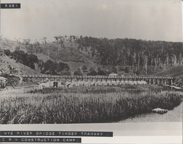
Photograph - Black and white photograph, Wye River Bridge Timber Tramway
Photograph showing the Wye River Bridge Timber Tram way at the C.R.B Construction Campwye-river-bridge, timber-tramway, c.r.b.-construction-camp, wye river bridge, timber tramway, c.r.b. construction camp, country roads board -
 Lakes Entrance Historical Society
Photograph - Bridges
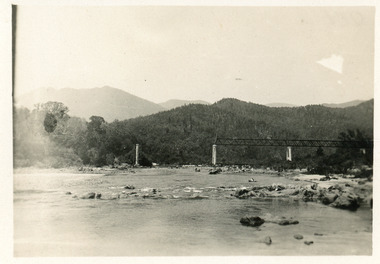
Black and white photograph showing partially built McKillops Bridge on Snowy River, East Gippsland, Victoria.Cantilever new bridge over Snowy River at McKillops Crossing, 45 feet above recorded flood, washed away before officially opened, decking, etc, down stream more than a mile. (on back)bridges, waterways, topography, construction -
 Lakes Entrance Historical Society
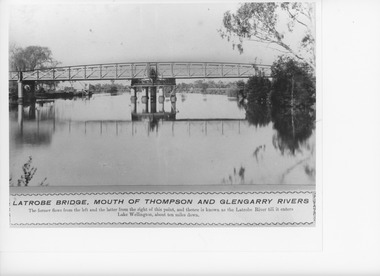
Photograph, Caire, Nicholas John, Swing Bridge Sale Victoria, 1905c
turning on a central axis to allow the passage of river vessels. Image shows machinery for operation and the bridge closed to river traffic. Latrobe Wharf on the left bank is seen through bridge. Sale VictoriaBlack and white photograph of the Latrobe Bridge. This was a swing bridge over the Latrobe Riverbridges, waterways, civil engineering, jetties -
 Chelsea & District Historical Society Inc
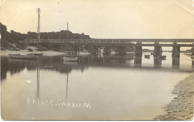
Photograph - Patterson River, Rail and Road Bridge
The first bridge over the river was built in the early 1880's, prior to this it was a pontoon bridge.Black and white photo of the road bridge (Point Nepean / Nepean Highway) and rail bridge, near the mouth of the Patterson River. Taken from the mouth of the river.patterson river, road bridge, rail bridge, chelsea, transport, patterson river bridge, carrum bridge -
 Orbost & District Historical Society
postcard, C1920-1940
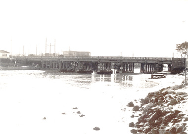
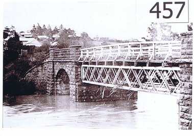
This photograph shows the second major bridge across the Snowy River at Orbost. The current Snowy River bridge is the fourth to provide a crossing to the township of Orbost. The first, in 1891, lasted just two years before it succumbed to flood waters. The bridge in this photograph was built in the 1920s as a road and rail bridge, and was again partly washed away by flood waters in 1934. After the end of the first World War the Victorian Railways considered an extension of the railhead across the river at Orbost, and in 1922 a new timber and steel girder structure, a joint Country Roads Board — Victorian Railways venture, was built and completed at a cost of £41,000 (the steel girders came from the Flinders Street viaduct reconstruction). Subsequently it was decided not to take the railway across the river, and the bridge was only used by road traffic. It was severely battered by floods during its life. and after the 1971 floods was eventually replaced by the current bridge in 1975. (info from Newletter 54N by John Phillips) This item is an early pictorial record of the previous Snowy River bridge at Orbost.A postcard with a black / white photograph of a bridge - timber and steel girder structure - across the Snowy River at Orbost, Reflections of the bridge are seen in the water.snowy-river-bridge-orbost -
 Chelsea & District Historical Society Inc
Photograph - Patterson River, Rail and Road Bridge, Carrum
The first bridge over the river was built in the early 1880's, prior to this it was a pontoon bridge. In 1927 a concrete bridge was built to replace the wooden bridge.Black and white photo of Patterson River, looking east from the Port Phillip Bay. PATTERSON RRIVER BRIDGE, CARRUMpatterson river, chelsea, patterson river bridge, carrum bridge, canoes, beach, leisure -
 Orbost & District Historical Society
black and white photograph, C 1890s -1910
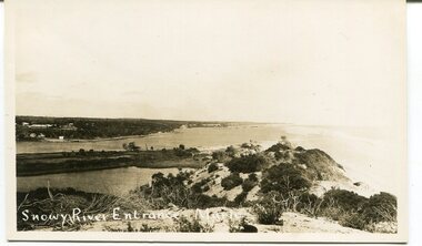
This is a photograph of the entrance of the Snowy River to Bass Strait. The entrance changes location but remains open for most of the year, although on occasions is closed by the prevailing weather and river water levels. In this photograph the entrance is quite wide and near the Marlo Hotel. This is a pictorial record of the Snowy River entrance at Marlo showing an open entrance.A black / white photograph / postcard of sandhills, river water on left and ocean on right. There is a group of buildings in the background - left. on front - "Snowy River Entrance Marlo"snowy-river-entrance marlo-snowy-river -
 Lakes Entrance Historical Society
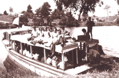
Photograph, Peels launch Zephyr on Tambo River near bridge at Swan Reach Victoria, 1940 c
Black and white photograph of Peels launch Zephyr filled with passengers moored at landing place on Tambo River near bridge at Swan Reach Victoria. Also a second black and white photograph of Peels launch Zephyr in Tambo River with Swan Reach bridge in backgroundboats and boating, tourism, rivers -
 Orbost & District Historical Society
black and white photograph, late 19th century
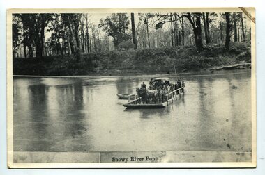
A punt crossed the Snowy River at Orbost from 1884. A bridge was constructed in 1893, but was soon damaged by a huge flood. Flooding was a regular occurrence, the worst inundations being in 1870, 1893, 1925, 1934, 1952 and 1971. Over the years major flood protection works have been implemented. The Princes Highway, which passes Orbost, now crosses the flood plain on raised concrete supports. (info, from Victorian Places Orbost)This item is associated with the Snowy River and its history. It is a pictorial record of transport in the late 19th century.A black / white photograph (copy) of a punt loaded with people and a horse-drawn carriage making its way across a river.on front at bottom - "Snowy River Punt"snowy-river-orbost transport shipping -
 Greensborough Historical Society
Photograph, Plenty River Greensborough, 1910c
It shows the Plenty river in Greensborough in flood and the bluestone bridge at the bottom of the Main Street hill.The bluestone bridge was built in the mid 1860's and was demolished 1970's.A black and white photograph of a bridge over a river in flood.Nilgreensborough, plenty river, floods, bridges, bluestone -
 Lakes Entrance Historical Society
Book, Davidson, Rachael, The Nicholson River Railway Bridge, 2004
Research, interpretation and management recommendations for the Nicholson River Railway Bridge, East Gippsland, Victoria, by a Forestec student.bridges, transport -
Lakes Entrance Historical Society
Book, Van der Heyden Becky, Calulu Mitchell River Bridge, 2004
Research interpretation and management recommendations for the Calulu Mitchell River Bridge, near Bairnsdale, Victoria by a Forestec Studentbridges, waterways, settlers -
 Orbost & District Historical Society
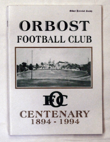
book, Orbost Football Club Centenary 1894 - 1994, 1994
This book was made for celebration of the centenary of the Orbost Football Club in 1994. The Orbost football club players were known as the Busters and wore green and gold guernseys. An Orbost football team has participated in the East Gippsland League since the early 20th century. In 2003 in response to a dwindling population, the Snowy Rovers and Orbost Football Clubs were driven to merge into the Orbost Snowy Rovers.Orbost Football Club through its many changes has always been an important social fabric of the Orbost community. Sport is often regarded as an important part of life in rural Australia, contributing to community identity, sense of place, social interaction and good health.A soft covered book of white with large green and gold print on the cover. There is a photograph of a football ovel with a township behind it.orbost-football-club-centenary recreation sport football -
 Federation University Historical Collection
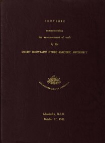
book, Truth & Sportsman Ltd, Souvenir commemorating the commencement of work by the Snowy mountains hydro-electric authority, 17/10/1949
It is assumed that a member of the Ballarat School of Mines attended the commencement of work at the Snowy Mountains hydro-electric centre.Burgundy cover with gold printing. Black print, photos and diagrams on white paper (31 pages). Bound by 3 staples. The contents include the story of the Snowy. Images include W.J. McKell, J.B. (Ben) Chifley, J. McGirr, Nelson Lemmon, Hume Weir, Jindabyne valley (now flooded), Jindabyne township (now flooded), illustration of water Power, survey team at Adaminaby, Snowy Mountains Relief Plan, Horseman crossing the Eucumbene River, Mildura, Burrinjuck Dam under construction, transmission lines, W. Hudson.snowy mountains hydro-electricty scheme, snowy mountains hydro-electric authority -
 Orbost & District Historical Society
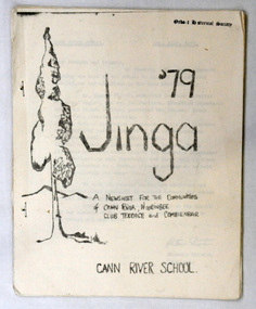
newsletter, Jinga, July 1979
Cann River is 75 km east of Orbost. The Cann River School newsletter is published fortnightly and includes a calendar of upcoming activities in the school and local community. When the newsletter started (probably in 1968) there was a discussion in the school as to what it would be called - Jinga eventually came out of that and it's still the same today. Jinga derived its name from Croajingolong. Croajingolong possibly comes from the Aboriginal words for 'belonging to' and 'east' and is the name of one of the five clans of the Kurnai (Gunni) - the Krauatungalung, who lived in this region. It is likely that the decision to go with 'Jinga' over 'Jingo' was made by popular vote. For a few years the school published a year magazine called Croalong, and now combines the two so the last issue of Jinga for the year is actually titled Croajingolong! (Information provided by Ruby, current editor of Jinga.) In small rural communities newsletters are an important communication medium. Cann River P-12 College has played a significant part in the education students in the Cann River district . It is the sole educational institution in Cann river. A newsletter for Cann River School. It contains black and white photographs, children's work and reports.newsletter-jinga cann-river -
 Federation University Historical Collection
Correspondence, Letter from Lance Matthews concerning the Snowy Mountains Scheme, 1958, 25/11/1958
Lance Matthews was a former student of the Ballarat School of Mines. Dick Richards was the Principal Construction of the Snowy Scheme was managed by the Snowy Mountains Hydroelectric Authority, it officially began on 17 October 1949 and took 25 years, officially completed on 21 October 1972.A letter comprising of three handwritten pages discussing experiences of work with the Snowy River Authority by Lance Mattews. The letter was written to Richard W. Richards, Principal of the Ballarat School of Mines. A forth page is a response to the letter by Dick Richards. In the letter Matthew relates that he is living at Cooma in the East Camp, and compares the living condition to an army camp. Matthew was working for contractors, Kaiser Walsh, at the Base Plant Pool at Polo Flat about 2 miles out of Cooma. He was involved in a two week tour (inventory) of the Snowy River Scheme and saw most part of the project including Adaminaby Dam, Tunnel Pond, T1 power station and the sites and initial stages of Tooma Reservoir, Lobs Hole Reservoir, Jindabyne Reservoir and several access tunnels..dick richards, lance matthews -
 Lakes Entrance Historical Society
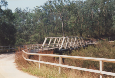
Photograph - Murrindal River Bridge Murrindal Victoria, 1/03/2000 12:00:00 AM
Colour photograph of the timber bridge across the Murrindal River Murrindal Victoria. Also a second colour photograph showing approach to bridge with signs prohibiting cattle droving and use of side track.bridges, forest, civil engineering -
 Orbost & District Historical Society
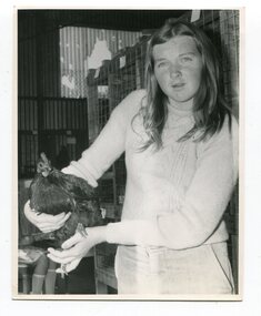
photographs, Snowy River Mail, C1968
These photographs were probably published in the Snowy River Mail. Some of the Orbost identities in the photographs are: Jim Holden; Brian Morgan; Clarrie Ingram; Jeffrey Fecondo; David Holden; Brian Holden; Richard Morgan; Sue Joiner and Charlie Owen. They were taken in the Poultry Shed at the Orbost Show at the Newmerella Showground. The first meeting to form an Agricultural society in Orbost was convened by the then Orbost Progress Association and held in the Mechanics Hall on Saturday, 10th October 1891. Its first show was held on 3rd March 1904...on a site alongside the Bonang Road where the present Golf Club stands. It is currently held at the Recreation Reserve at Newmerella. (Ref: In Times Gone By-Deborah Hall)These photographs are associated with the Orbost Agricultural Society 's Annual Show which has been a major event in Orbost for over a century. Agricultural shows are an important part of cultural life in small country towns and the Orbost Show is an integral part of Orbost 's agricultural history.Twenty-two black / white photographs and four coloured photographs. all are related to the Orbost Agricultural Show.poultry agriculture-show-orbost -
 Federation University Historical Collection
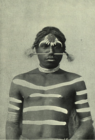
Image - black and white, Barwon River Man (New South Wales)
Digitised directly from 'The Native Races of the British Empire: Victoria' The Barwon River in New South Wales is formed through the confluence of the Macintyre River and Weir River (part of the Border Rivers system), north of Mungindi, in the Southern Downs region of Queensland. The Barwon River generally flows south and west, joined by 36 tributaries, including major inflows from the Boomi, Moonie, Gwydir, Mehi, Namoi, Macquarie, Bokhara and Bogan rivers. During major flooding, overflow from the Narran Lakes and the Narran River also flows into the Barwon. The confluence of the Barwon and Culgoa rivers, between Brewarrina and Bourke, marks the start of the Darling River.Black and white Image of an Aboriginal man from Barwon River, New South Wales. Aboriginal people from six language groups originally occupied the area of the Barwon River wetlands. These were the Ngemba, the Baranbinja, the Murrawari, the Ualayai, the Weilwan, and the Kamilaroi peoples. The Aboriginal people generally used the wetlands for hunting, fishing, and gathering uses, and for cultural association.(Wikipedia) The name "barwon" is derived from the Australian Aboriginal words of barwum or bawon, meaning great, wide, awful river of muddy water; and also baawan, a Ngiyambaa name for both the Barwon and Darling rivers. The history, culture and livelihoods of the local Aboriginal people are closely intertwined with the Barwon River and its associated tributaries and downstream flows. (Wikipedia)aborigine, aboriginal, barwon river -
 Orbost & District Historical Society
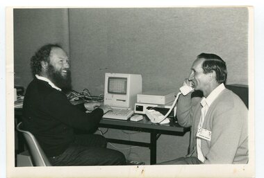
black and white photographs, Snowy River Mail, October 1987
In 3098.1 from L-R are John Pritchard and Graeme Rodier. Jeff Wilson is in 3098.2. Both photographs are connected to Adult Learning TAFE and CEP. These photographs were taken at the Curriculum and Technology in Schools workshop held in Bendigo, Victoria in October 1987. Eighty rural primary schools were involved including many from East Gippsland. From the Snowy River Mail; " A large number of technologies was......demonstrated at the conference. Participants were given hands on experience with audio and computer conferencing, CD Rom. an Invicon booth ( individual video console (INVICON) enables any teacher to produce short, relevant teaching videos for individual pupils without assistance), packet radio, videodisk, robotics and many more...." This is a pictorial record associated with education in Orbost.Two black / white photographs of two men seated at a desk with computers. The man on the right is holding a phone.education-east-gippsland tecnology -
 Stawell Historical Society Inc
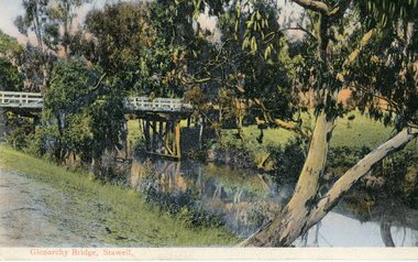
Postcard, Bridge at Glenorchy -- Postcard -- Coloured
Coloured postcard of Bridge at Glenorchy.Coloured Post card of a timber bridge over a river in bush settings.On Front Glenorchy Bridge, Stawell On Reverse Printed in Germany 155/81467 Post Card This Space May be used for Correspondence. This for Address Only.water -
 Federation University Historical Collection
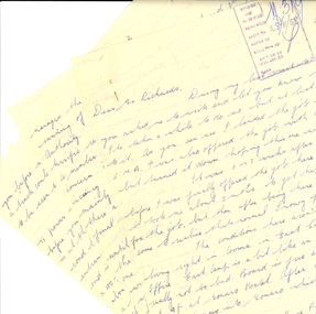
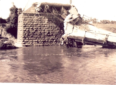
Photograph - Photographs, Richard Vincent, Washed Away Bridge at Garibaldi, c1933
Newspaper clipping documents deputations to the Minister of Public Works for grants to be made available for repairs to bridges and roads damaged by heavy flooding in 1933, in particular, the replacement of a stone and concrete bridge over the Leigh River at Garibaldi in the Buninyong Shire. The concrete slabs were still in the water in the 1960s/70s or even later. Three black and white photographs showing flood damage to the bridge over the Leigh River at Garibaldi, plus a photocopy of a newspaper clipping from The Argus December 1933 describing the extent of the flood damage. .1) shows blue stone buttress and collapsed bridge/road. .2) mirror image of above .3) unknown man waling an a girder of the Garibaldi bridge .4) photocopy of newspaper clipping about flood damage from The Argus December 1933Damage by Floods: Bridges washed away (The Argus December 1933)leigh river, garibaldi, buninyong shire, richard vincent, garibaldi bridge -
 Chelsea & District Historical Society Inc
Photograph - Patterson River, Rail and Road Bridge, c 1912
The first bridge over the river was built in the early 1880's, prior to this it was a pontoon bridge.Sepia photo of the road bridge (Point Nepean / Nepean Highway) and rail bridge, near the mouth of the Patterson River., Carrum patterson river, road bridge, rail bridge, chelsea, transport, patterson river bridge, carrum bridge -
 Orbost & District Historical Society
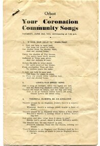
program, 1953
This program was produced by the Snowy River Mail for a community singalong held in Orbost on Tuesday June 2 1953 to celebrate the coronation of Queen Elizabeth 11. In June 1953 , Elizabeth II was crowned Queen of the United Kingdom, Canada, Australia, New Zealand, South Africa, Ceylon (now Sri Lanka), and Pakistan, and became the Head of the Commonwealth. The coronation of Queen Elizabeth II as monarch took place on 2 June 1953. Elizabeth ascended the throne at the age of 25, upon the death of her father, King George VI, on 6 February 1952, and was proclaimed queen by her various privy and executive councils shortly afterwards. The coronation took place more than a year later because of the tradition that holding such a festival is inappropriate during the period of mourning that follows the death of a monarch. This community event was typical of the general feeling of respect and admiration felt by the rural communities towards the British Royal Family. This item reflects the significance of monarchy for Australia and the constitutional history of Australia.The item reflects the interest in the royal family to Australians at this time as well as the general feeling of respect and admiration felt by the rural communities towards the British Royal Family.A white paper program with the words of songs printed in black. There is a rust mark from a metal staple in the top left corner. It is titled "Your Coronation Community Songs".queen-elizabeth-11 royalty community-event-orbost souvenir-program -
 Orbost & District Historical Society
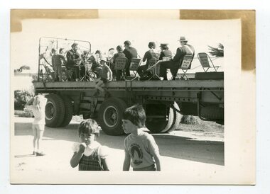
black and white photograph, October 4 1978
From the Snowy River Mail October 4 1978 page 9 - " A MOBILE BAND - Although Orbost Municipal Band participated in Saturday's Primary School workathon, members feet didn't touch the ground. They idi it bthe easywayon the trailer of a truck. The band encouraged walkers with stirring music along the road to Marlo." The first Orbost Brass Band was formed in 1889. Around 1908 the town band split and the Orbost Workers' Band was formed. Eventually the two bands merged in 1913 to reform as the Orbost Municipal Band under conductorship of Charles Spink. The band continued for many years but was later disbanded and again reformed. This was to happen a number of times, the last time being in 1961 and continuing through to the late 1970's. Further info and Ref: In Times Gone By - Deborah Hall This is a pictorial record of the Orbost Municipal Band. The various Orbost bands over the years played a major role in community activities providing entertainment and musical experiences for the many members.A black / white photograph showing a group of uniformed band members sitting on folding chair s on the tray of a large flat bed truck. They are holding musical instruments. A young boy is sitting on the edge of the tray and three other children are standing on the road nearby.on back - information from S.R.M.music orbost-municipal-band entertainment recreation -
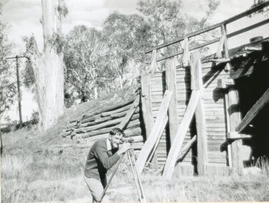 Stawell Historical Society Inc
Photograph, Old Wooden Bridge - over the Wimmera River at Joel Joel being surveyed by Allan Rowe for a new bridge 1951
Old Wooden Bridge - Joel Joel (Wimmera River) 1951 being surveyed by Allan Rowe for new bridgestawell shire