Showing 173 items matching "victoria. lands department"
-
 Stawell Historical Society Inc
Map, Department of Lands and Survey, Borough of Stawell. Parishes of Stawell and Illawarra 1903, 1903
Victoria Co., St Georges Co., Wimerra Co., Leviathon Co. Tramway, Quarry reserve, Newington Co., Galatea Co., Moonlight Co., Federal Co., Borough reservior., A0 Map of Stawell on linen backing. Plus one Printed on PaperPhoto Lithograped at the Department of Lands and survey Melbourne by T.F. McGauran 13.6.03surevy -
Stawell Historical Society Inc
Book - Report, Grampians National Park Draft Management Plan, 1985
For Public comment to National Park Service, Victoria. A Division of the department of Conservation, Forest and LandsSoft Cover with B/W Photo of aerial view of ranges of Grampians. Black taped Spine binding.$5 Barry Clugston -
 Stawell Historical Society Inc
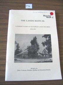
Book, Peter Cabena, Heather McRae & ElizabethBladin, The Lands Manual - A Finding guide to Victorias Lands Records 1836-1983, 1989
The Purpose of this manual is to describe the documentary archives of the Department of Crown Lands and Survey (Lands Department) and Explain, how they can be used for historical researchYellow card Cover Black Print and B/W Photo of two wooden buildings The Lands Manual A Finding guide to Victorian Lands Records 1836-1983 Written by Peter Cabena, Heather McRae & Elizabeth Baldinstawell -
 Stawell Historical Society Inc
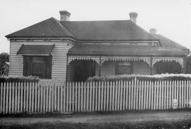
Photograph, Albert Davey, 20 Sloane Street Stawell 1950
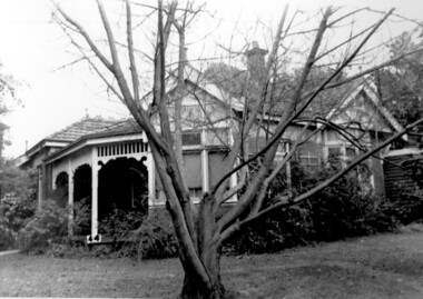
Home 20 Sloane Street Stawell taken in 1950 by Albert Davey who resided there with his family. House has three chimneys bull nose verandah with cast iron lacework, weatherboard construction with picket fence. Albert (Bert) worked for the Lands Department and his family consisted of 4 girls oldest being Aubrey about 18, Beverley about 16, Gwenda about 14 and the baby Faye about 4. and Alberts wife Phyllis. Albert worked all over Victoria from Buchan where they lived in the Caves Residence for 6 months, in Omeo, Yackandandah, Stawell, Wangaratta and Shepperton and then Melbourne where he took on the top job of Chief Superintendent of the Lands Dept. Now, 2018 uses as a cottage for distributing food by Inter Church CouncilResidence 20 Sloane Street Stawell housing -
Whitehorse Historical Society Inc.
Document, Annual Report, 1968
Annual Report of the Place Names Committee of Victoria for the year ended 30 June 1968. Department of Crown Lands and Survey.Annual Report of the Place Names Committee of Victoria for the year ended 30 June 1968. Department of Crown Lands and Survey.Annual Report of the Place Names Committee of Victoria for the year ended 30 June 1968. Department of Crown Lands and Survey.crown lands, victorian government, victoria. place names committee -
Whitehorse Historical Society Inc.
Map, Aerial photographs Nunawading, 1972
... Victoria. Department of Crown Lands and Survey.... Sheets 39/2 and 34/28 missing. Victoria. Department of Crown ...Department of Crown Lands and Survey, Melbourne, 1972.Department of Crown Lands and Survey, Melbourne, 1972. Project runs 34 - 39 - City of Nunawading. frames numbered from South to North boundaries, each strip numbered from West to east. The series extends further West to Box Hill and East to Ringwood than the 1970 project. No index map. Sheets 39/2 and 34/28 missing.non-fictionDepartment of Crown Lands and Survey, Melbourne, 1972.victoria. department of crown lands and survey, aerial photographs, nunawading, mitcham, blackburn, blackburn north, blackburn south, forest hill, vermont, burwood east, box hill, ringwood, vermont south -
Whitehorse Historical Society Inc.
Map, Aerial photographs Nunawading, 1976
... Victoria. Department of Crown Lands and Survey.... Department of Crown Lands and Survey Aerial Photographs Nunawading ...Department of Crown Lands and Survey, Melbourne, 1976 Project.Department of Crown Lands and Survey, Melbourne, 1976 Project. Runs 29 - 33 City of Nunawading. Frames numbered from South to North boundaries, each strip numbered from West to East. No index map. Sheets 30/8 and 30/9 missing.non-fictionDepartment of Crown Lands and Survey, Melbourne, 1976 Project. victoria. department of crown lands and survey, aerial photographs, nunawading, mitcham, blackburn, blackburn north, blackburn south, forest hill, vermont, vermont south, burwood east, box hill, ringwood -
Whitehorse Historical Society Inc.
Map, M.M.B.W, c1962
... Victoria. Department of Lands and Survey... and Metropolitan Board of Works Victoria. Department of Lands and Survey ...Melbourne Metropolitan Area Base Map series sheet 235, covering part, Mitcham, Nunawading and Ringwood areas.Melbourne Metropolitan Area Base Map series sheet 235, covering part, Mitcham, Nunawading and Ringwood areas. Prepared by Department of Lands and Survey and Melbourne and Metropolitan Board of Works from State aerial Survey, June 1957 and Cadastral Survey information, August 1960. Scale 1:4,800.Melbourne Metropolitan Area Base Map series sheet 235, covering part, Mitcham, Nunawading and Ringwood areas. maps, mitcham, nunawading, ringwood, melbourne and metropolitan board of works, victoria. department of lands and survey -
Whitehorse Historical Society Inc.
Article, Apex needs new blood, 1991
... victoria. department of conservation and lands... Mitcham melbourne service clubs secker geoff victoria. department ...Nunawading Apex club urgently wanting new members.Nunawading Apex club urgently wanting new members. They have just won a grant from the Department of Conservation and Lands to construct an observation tower at the rear of the waste transfer station on Burwood Highway, but they need more members to carry the project through, says Geoff Secker,. membership chairman.Nunawading Apex club urgently wanting new members. service clubs, secker, geoff, victoria. department of conservation and lands, nunawading apex club, waste transfer station, vermont south -
 Whitehorse Historical Society Inc.
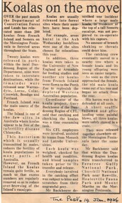
Article, Koalas on the move, 14/01/1986 12:00:00 AM
Article from 'The Post' 14 January 1986 about relocation of koalas by the Department of Conservation, Forests and Lands.Article from 'The Post' 14 January 1986 about relocation of koalas by the Department of Conservation, Forests and Lands.Article from 'The Post' 14 January 1986 about relocation of koalas by the Department of Conservation, Forests and Lands.wildlife, koalas, victoria. department of conservation forests and lands -
 Whitehorse Historical Society Inc.
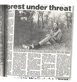
Article, Forest under threat, 13/09/1986 12:00:00 AM
An article in the Nunawading Gazette, naturalist John Reid has asked Council to commission a survey of flora and fauna of Antonio Park, Mitcham before this significant bushland remnant is impossible to save.native plants, antonio park, mitcham, reid, john, robinson, randall, victoria. department of conservation forests and lands -
 Whitehorse Historical Society Inc.
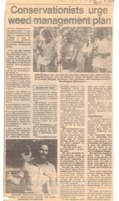
Article, Conservationists to urge weed management plan, 5/04/1989 12:00:00 AM
Article from Nunawading Gazette dated 5 April 1989 about a weed management plan in the City of Nunawading.environment, weeds, victoria. department of conservation, forests and lands., native plants, edwards, margaret, meagher, dorothy, witherspoon, cameron, david -
 Bendigo Historical Society Inc.
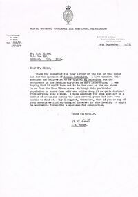
Document - PETER ELLIS COLLECTION: LETTER, 24th September, 1973
Letter, dated 24th September, 1973, to Mr P N Ellis from A B Court of the Royal Botanic Gardens and National Herbarium. In the A B Court thanks Mr Ellis for his letter and for the specimen of Acacia hakeoides. He was hoping it would turn out to be the same as the one known to him from the Moon Mines area. He had searched for this species? During the last several years but had been unable to find it. He suggest that if Mr Ellis or his associates find anything of interest in the locality it might be worthwhile forwarding a specimen for examination. Signed A B Court.communication, postal, letters, peter ellis collection, department of crown lands and survey victoria, royal botanic gardens and national herbarium, p n ellis, moon mines area, a b court -
Bendigo Historical Society Inc.
Map - NERRING : COUNTY OF BENDIGO, August 1952
Map. Nerring, County of Bendigo, Leichardt, Marong, Sandhurst, Huntly, Neilborough, Yarraberb. Drawn and Reproduced at the Department of Lands and Survey, Melbourne, Victoria, August 1952, Price 2/-.( number 409 in Map Cupboard 1).J.J. Gourley, Government Printer, Melbourne.bendigo, hospital -
 Bayside Gallery - Bayside City Council Art & Heritage Collection
Map, Department of Crown Lands and Survey et al, Moorabbin, County of Bourke, Government Roads, 1920
The cadastral map of the Parish of Moorabbin in Victoria (L.6104) shows parish boundaries and land ownership 1920 when Sandringham was a Town. The government roads have been coloured in red pencil.moorabbin, county of bourke, map, plan, land subdivision, land titles, foreshores, hampton, beaumaris, highett, cheltenham, department of lands and survey, land owners, cartographic material, brighton, sandringham, town of sandringham, government roads -
 Bayside Gallery - Bayside City Council Art & Heritage Collection
Photograph, Department of Crown Lands and Survey, Victoria, Melbourne Project: Brighton and Elwood, 1976
The Department of Crown Lands and Survey (1857-1983) was responsible for the administration of survey and mapping and the sale, occupation and management of crown land throughout its existence. This aerial photograph shows parts of Brighton and Elwood and was taken on 1 December 1976brighton, elwood, department of crown lands and survey, aerial photograph, elsternwick park, point ormond, north road, ormond esplanade, st kilda street, glen huntly road, bayside, port phillip bay, map, cartographic material, melbourne project 1976 -
 Bayside Gallery - Bayside City Council Art & Heritage Collection
Photograph, Department of Crown Lands and Survey, Victoria, Melbourne Project: Brighton, Hampton, Sandringham, 1976
The Department of Crown Lands and Survey (1857-1983) was responsible for the administration of survey and mapping and the sale, occupation and management of crown land throughout its existence. This aerial photograph shows parts of Brighton, Hampton and Sandringham and was taken on 1 December 1976brighton, department of crown lands and survey, aerial photograph, bayside, port phillip bay, map, cartographic material, hampton, sandringham, green point, sandringham yacht club, south road, beach road, hampton street, melbourne project 1976 -
 Bayside Gallery - Bayside City Council Art & Heritage Collection
Photograph, Department of Crown Lands and Survey, Victoria, Melbourne Project: Brighton, 1976
The Department of Crown Lands and Survey (1857-1983) was responsible for the administration of survey and mapping and the sale, occupation and management of crown land throughout its existence. This aerial photograph shows parts of Brighton and was taken on 1 December 1976brighton, department of crown lands and survey, aerial photograph, bayside, port phillip bay, map, cartographic material, melbourne project 1976, brighton yacht club, middle brighton baths, north road, st kilda street, new street -
 Bayside Gallery - Bayside City Council Art & Heritage Collection
Photograph, Department of Crown Lands and Survey, Victoria, Melbourne Project: Brighton and Hampton, 1976
The Department of Crown Lands and Survey (1857-1983) was responsible for the administration of survey and mapping and the sale, occupation and management of crown land throughout its existence. This aerial photograph shows parts of Brighton and Hampton and was taken on 1 December 1976. brighton, department of crown lands and survey, aerial photograph, bayside, port phillip bay, map, cartographic material, melbourne project 1976, brighton yacht club, middle brighton baths, hampton, green point, brighton beach, south road, the esplanade, hampton street -
 Bayside Gallery - Bayside City Council Art & Heritage Collection
Photograph, Department of Crown Lands and Survey, Victoria, Brighton, Elwood and Elsternwick, c. 1965-71
The Department of Crown Lands and Survey (1857-1983) was responsible for the administration of survey and mapping and the sale, occupation and management of crown land throughout its existence. This aerial photograph shows parts of Brighton, Elwood and Elsternwick and was taken circa 1965-71.brighton, department of crown lands and survey, aerial photograph, bayside, port phillip bay, map, cartographic material, elwood, elsternwick, elsternwick park, elwood tram depot, elwood pier, new street, glen huntly road, st kilda street, nepean highway -
 Bayside Gallery - Bayside City Council Art & Heritage Collection
Photograph, Department of Crown Lands and Survey, Victoria, Brighton, Brighton East and Bentleigh, c. 1965-71
The Department of Crown Lands and Survey (1857-1983) was responsible for the administration of survey and mapping and the sale, occupation and management of crown land throughout its existence. This aerial photograph shows parts of Brighton, Brighton East and Bentleigh and was taken circa 1965-71.brighton, department of crown lands and survey, aerial photograph, bayside, port phillip bay, map, cartographic material, bentleigh, brighton east, dendy park, dendy street, centre road, nepean highway, south road, football -
 Bayside Gallery - Bayside City Council Art & Heritage Collection
Photograph, Department of Crown Lands and Survey, Victoria, Brighton, Brighton East and Bentleigh, c. 1965-71
The Department of Crown Lands and Survey (1857-1983) was responsible for the administration of survey and mapping and the sale, occupation and management of crown land throughout its existence. This aerial photograph shows parts of Brighton and Brighton East and was taken circa 1965-71.brighton, department of crown lands and survey, aerial photograph, bayside, port phillip bay, map, cartographic material, brighton east, dendy park, dendy street, centre road, nepean highway, south road, brighton golf course, golf -
 Bayside Gallery - Bayside City Council Art & Heritage Collection
Map, Department of Crown Lands and Survey, Moorabbin, County of Bourke, c. 1918
The cadastral map of the Parish of Moorabbin in Victoria (L.6104) shows parish boundaries and land ownership c. 1918 when Sandringham was a Borough.moorabbin, county of bourke, map, plan, land subdivision, land titles, foreshores, sndringham, hampton, beaumaris, highett, cheltenham, department of lands and survey, land owners, cartographic material, borough of sandringham, brighton -
 Bendigo Historical Society Inc.
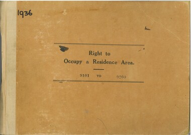
Administrative record - Right to Occupy Certificates, 1936
Twelve books containing stubs of Right to Occupy Certificates for 1936. Includes name and address of person receiving the Right to Occupy certificate and the description of the land including allotment, Section, City, Town, Borough or Township and Parish name. List of record Numbers in Box 906 Some items have pencil and pen marks and ink stains.right to occupy, central victoria -
 Surrey Hills Historical Society Collection
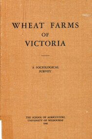
Book, Wheat farms of Victoria: a sociological survey, 1946
The owner, Alan Judge Holt lived locally and was Secretary of the Lands Department. Donated by Max Holt who was one of his sons. This book goes into considerable detail on all facets of wheat farm life, providing the basis for a real understanding of the problems of the man who grows wheat.Cloth-covered hardback book of 179p. Alan J. Holtwheat, social surveys, agriculture, (mr) alan holt, farming -
 Surrey Hills Historical Society Collection
Digital photo, 'Pymble', 2 Earle Street, Mont Albert
... Department of Victoria during his working life. He was a keen... of the Lands Department of Victoria during his working life. He ...Pymble’, 2 Earle Street was built in 1907 with additions in 1915. It was the home of Alan and Edna Holt and family from 1958-1966. Alan Judge Holt was Secretary of the Lands Department of Victoria during his working life. He was a keen and meticulous local historian, whose work contributed significantly to this collection. The house is extant in 2020, but Earle Street is now Earle Close.A black and white photograph of a Queen Anne style house. There are a couple of bay windows and a verandah using timber fretwork.pymble, house names, earle street, mont albert, mr alan holt, mrs edna holt, queen anne style -
 City of Greater Bendigo - Civic Collection
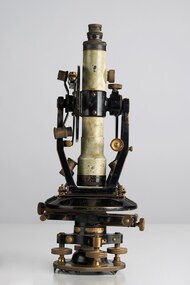
Instrument - Theodolite, E. R. Watts & Sons, c 1930
Theodolites are a highly accurate instrument that measures angles between designated visible points in the horizontal and vertical planes. The theodolite has a long history, with the term first found in 1571 in a surveying textbook 'A geometric practice named Pantometria' by Leonard Digges. (source https://en.wikipedia.org/wiki/Theodolite). Theodolites are used by surveyors as part of their everyday work and although there is no specific information regarding the provenance of this particular one it is assumed it was used locally by the Shire of Marong and / or the Lands Department. Edwin Watts started the company in 1856, trading up to 1920s as E.R. Watts & Son with E. R. Watts & Son Ltd amalgamating with Adam Hilger Ltd to form Hilger & Watts in 1948.0442.1 A black and grey theodolite no 39161 made by Watts & Sons. Various moving parts showing signs of extensive use particularly on the uprights on the main body and around knobs and dials where the paint is worn back to brass. Is housed in original box with key, oil container and pin. 0442.2 handwritten instructions for making adjustments to the Theodolite written on the back of Road Users' Association of Victoria letterhead note paper.Watts & Sons / London / 5974 For N H Seward / Melbournelands and survey department bendigo, shire of marong -
 Wodonga & District Historical Society Inc
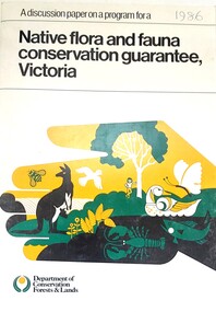
Book - Discussion Paper on Native flora and fauna conservation guarantee, Victoria, Department of Conservation, Forests and Lands, Victoria, 1986
This publication was produce as a discussion paper to inform decisions related to changes in land management and conservation regulations and policy in 1986An A4 size document outlining findings into an investigation into the state of flora and fauna in Victoria.This publication was produce as a discussion paper to inform decisions related to changes in land management and conservation regulations and policy in 1986land management, conservation victoria, water conservation -
 Wodonga & District Historical Society Inc
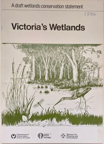
Book - Victoria's Wetlands, Dept. of Conservation, Forests & Lands, 1986
... & Lands, Department of Water Resources, Victoria, Ministry... of Conservation, Forests & Lands, Department of Water Resources, Victoria ...This publication was the result of an inquiry into the state of wetland environments in Victoria. It produced a draft strategy for conservation of threatened areas in the future.An 22 page book containing maps and illustrationsThis publication was the result of an inquiry into the state of wetland environments in Victoria. It produced a draft strategy for conservation of threatened areas in the future.wetland protection, wetlands victoria, water conservation -
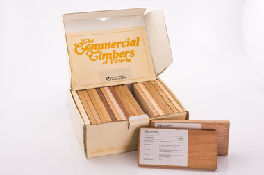 Forests Commission Retired Personnel Association (FCRPA)
Commercial timbers of Victoria, Sample Box
Some decades ago a card sorting set for the identification and description of Australian timbers was developed for timber species which were available commercially and were in common usage, by the Commonwealth of Australia (CSIRO, Division of Forest Products) To complement and inform this national timber set each State or Territory developed reference timber sets of representative species. The Commercial Timbers of Victoria set was Victoria’s most recent (circa 1984) expression of this Victorian timber samples were sourced from logs selected by Forest Commission of Victoria (FCV) District Foresters and milled locally. Kiln drying and machining was carried out at timber producers Row, Web and Anderson, in Port Melbourne. Labeling and boxing was done by FCV Timber Inspectors, with box and booklet design and graphics handled in-house More recent timber samples were badged as Conservation Forests & Lands, reflecting historical government restructuring in the early 1980s Info: Simon MurphyProvided the public, industry (timber and associated), and educational facilities with a reference collection of notable Victorian timbers. Initially in a reduced format from 1940-50s, with boxed sets produced from 1981 until 1984A boxed set of timber samples representing the 20 tree species that were considered to be the most notable in Victoria. The set also includes an information booklet. Each timber specimen has information on species, occurrence, uses and physical properties Produced for sale by the the FCV and later by the Department of Conservation Forests and Lands. (CFL). forests commission victoria (fcv)