Showing 3175 items matching "bridge street"
-
 Orbost & District Historical Society
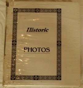
book, Historic Photos, c 1986
... residents , businesses, streets, transport, scenery, bridges...Orbost & District Historical Society Ruskin Street Orbost ...This book was compiled by volunteers at the Orbost Visitor Information Centre(Slab Hut) as a reference for visitors.This item is a useful reference tool.A white plastic-covered 2 ring binder with title Historic Photos inside cover. It contains photos of past and present residents , businesses, streets, transport, scenery, bridges and nearby places. It also contains a newspaper - Snowy River Holiday News (1986).orbost-history slab-hut -
 Orbost & District Historical Society
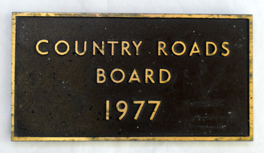
plaque, 1977
The Country Roads Board was the government authority for the construction and maintenance of main roads in Victoria between 1913 and 1983. It was succeeded by the Road Construction authority on 1 July 1983 and later merged with the Road Traffic Authority on July 1 1989 to form the Roads Corporation. James Cameron, an Orbost farming pioneer and Member of the Legislative Assembly, fathered the Country Roads Board. This plaque was possibly removed from a bridge(?) when the name was changed.A heavy rectangular shaped bronze plaque. the background is dark brown and the print and frame bronze coloured. On the back are two round recesses for screwing and attaching the plaque.COUNTRY ROADS BOARD 1977country-roads-board cameron-james -
 Orbost & District Historical Society
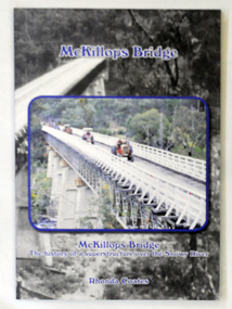
book, McKillops Bridge, 2014
This book was purchased new by Orbost & District Historical Society. Written by Buchan historian, Rhonda Coates, the book was commissioned by Tubbut Neighbourhood House following a commemoration event in 2002 when many people gathered for a special day organised by Sister Helen Barnes and the Tubbut community. (ref. Bombala Times)This book is a useful research item.A paper back book, titled McKillops Bridge, written by Rhonda Coates. On the front cover is a photograph tractors crossing the bridge during the Great Snowy River Tractor Stampede ( The Snowy River Tractor Strampede, a 560-kilometre journey, is organised by the Bega and District Historical Machinery Club every January - the first being held in 2009.) this photograph is inset over an earlier phpotograph by Howard Bulmer c 1936. The book contains the history of the bridge, photographs of the bridge and times before its construction.On front fly-Orbost &District Historical Society Incmckillops-bridge -
 Orbost & District Historical Society
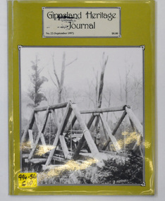
journal, Gippsland Heritage Journal, September 1997
This issue was edited by Meredith Fletcher.This item is a useful reference on the history of Gippsland.A 64 pp magazine, titled Gippsland Heritage Journal. The cover is olive green with a b/w photograph of the Snowy Creek bridge at Mitta Mitta in 1914. The magazine is dated September 1997 and is covered in plastic. It contains photographs and articles on the history of Gippsland.On the outside back cover is a library barcode. On the front is a call no. 994.56 GIPgippsland-heritage-journal history-gippsland -
 Orbost & District Historical Society
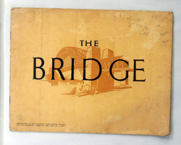
book, The Bridge, 1930's
This book was written by Dr J. J. C. Bradfield, (John Job Crew), 1867-1943. Dr JJC Bradfield was a visionary Australian engineer who worked with enormous energy and vision to build the infrastructure which he foresaw that Sydney would need as it grew. As early as 1903 Bradfield was making the case for the Sydney Harbour Bridge, in his presidential address as President of the Sydney University Engineering Society. Bradfield’s proposal — at that stage for a cantilever bridge between Dawes Point and Milsons Point — won the committee’s support and they recommended it be accepted. However, the First World War put a stop to these plans. While a bill to authorise the project passed the lower house of the NSW parliament in 1916, it failed to pass the upper house, on the grounds that funds should not be diverted from the war effort. With the war over, in 1922 the Sydney Harbour Bridge Act was passed by the NSW Parliament. The Sydney Harbour Bridge was officially opened in 1932 after Museum and St James railway stations were built. This book was written from the story broadcast by Dr. J.J.C. Bradfield. This item is a useful reference tool.A staple soft cover 16 pp booklet with a buff coloured cover. It has a sketch of the Sydney Harbour Bridge behind the title "The Bridge" in dark brown print. It contains information and photographs of the history and construction of Sydney Harbour Bridge.sydney-harbour-bridge bradfield-dr-j-j-c -
 Orbost & District Historical Society
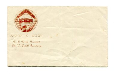
envelope, 1937
This envelope would have been made for the organising committee of the 1937 Back To Orbost celebration.This item was part of of a significant event held in Orbost. A small, white rectangular envelope. In the top left hand corner in dark brown is an illustration of maize, vegetables,a boomerang and the Snowy River Bridge enclosed in an oval frame. Inside the boomerang is "BACK TO ORBOST. 1937". Below is " 27 / 2 /39 to 6 / 3 /3" and below this is "Cr J. Perry President - M.W. Cowell secretary" printed in an ornate text..orbost-back-to-1937 envelope stationery -
 Orbost & District Historical Society
pamphlets, Princes Freeway - Orbost Section, 1976
Opened by the Hon. J A Rafferty, Minister for Transport, 25 November 1976, the bridge was the first of four bridges to be built as part of the freeway bypass of Orbost. Construction cost $2.4 million. This construction was an important development along the Princes Highway corridor through East Gippsland. The original highway approached the Snowy River at a very poor alignment, and several serious accidents had occurred at the Orbost end. In times of heavy flood, the highway on both sides of the river had been cut by floodwaters and during the 1971 floods, the highest ever recorded, the river was a mile wide at the crossing. Construction of the bridges commenced in January 1975, with an expectation to open the bridge across the Snowy River as soon as possible. Less than two years later, on 25 November 1976, the bridge across the Snowy River was opened to traffic, allowing the old bridge to be demolished. The remainder of the Orbost Bypass, both the floodplain crossings and the eastern section around the township itself, was declared ‘Princes Freeway’ and opened to traffic in December 1977. (ref http://mrv.ozroads.com.au) The Country Roads Board was the government authority for the construction and maintenance of main roads in Victoria between 1913 and 1983. It was succeeded by the Road Construction authority on 1 July 1983 and later merged with the Road Traffic Authority on July 1 1989 to form the Roads Corporation. James Cameron, an Orbost farming pioneer and Member of the Legislative Assembly, fathered the Country Roads Board. The opening of this Snowy River Bridge was an important development in the accessibility to the township of Orbost.Three coloured Country Roads pamphlets for the 'Princes Freeway - Orbost Section". On the front is a coloured photograph of the new construction over the Snowy River at Orbost. Inside is a program for a ceremony for the opening of the new Snowy River Bridge. There is also a black print map of the project. -
 Orbost & District Historical Society
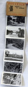
post cards, ca. 1945
This is a souvenir of Orbost from 1945.A set of 13 black and white postcards in a fold-out format. Pictures are of : Nicholson Street, Snowy Rriver flats from Grand View, avenue leading to Obost. Snowy River bridge at Orbost, Snowy River at Orbost, Marlo from the sand dunes, Prince's Highway at Victorian-NSW. border, Genoa River and bridge at Genoa, Prince's Highway at Mt. Drummer, Cann River hotel, fern scene, Euchre Valley, ponsasinorum near Cann River. SOUVENIR Orbost to Vic Border 13 camera viewspostcard souvenir photographs orbost cann-river -
 Orbost & District Historical Society
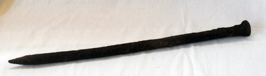
bridge spike
... Orbost & District Historical Society Ruskin Street Orbost ...A rusted iron bridge spike.bridge-spike -
 Orbost & District Historical Society
book, Snowy River Mail as "Mail" Print, Princes Freeway Orbost Section, 2117.1 : 1976 2117.2 : 4.9.2013
The Snowy River Bridge, Princes Freeway, Orbost, Victoria was opened by the Hon. J A Rafferty, Minister for Transport, 25 November 1976. ‘The bridge was built at a cost of A$2.4 million and is the first of four bridges to be built as part of the 8.4 kilometre freeway bypass of Orbost. Construction of the bridges commenced in January 1975, with an expectation to open the bridge across the Snowy River as soon as possible. Less than two years later, on 25 November 1976, the bridge across the Snowy River was opened to traffic, allowing the old bridge to be demolished. The remainder of the Orbost Bypass, both the floodplain crossings and the eastern section around the township itself, was declared ‘Princes Freeway’. The newspaper article was written by David Jellie as part of the centenary celebrations of Vic Roads/Country Roads on 4.9.2013. David Jellie was the project engineer for the Snowy River Crossing Project.This book and article contain historical information and details about the construction of the bridges on the Orbost section of the Princes Freeway.2117.1 isaA thin paperbook book which contains a map, history and construction details of the Princes Freeway at Orbost. It has a program for the opening ceremony of the snowy River Bridge in 1976. 2117.2 is an article from the snowy River Mail on the history of the highway. It is dated 4.9.2013.In pencil - 20csnowy-river-bridge jellie-david princes-freeway-orbost -
 Orbost & District Historical Society
postcard, C1920-1940
This photograph shows the second major bridge across the Snowy River at Orbost. The current Snowy River bridge is the fourth to provide a crossing to the township of Orbost. The first, in 1891, lasted just two years before it succumbed to flood waters. The bridge in this photograph was built in the 1920s as a road and rail bridge, and was again partly washed away by flood waters in 1934. After the end of the first World War the Victorian Railways considered an extension of the railhead across the river at Orbost, and in 1922 a new timber and steel girder structure, a joint Country Roads Board — Victorian Railways venture, was built and completed at a cost of £41,000 (the steel girders came from the Flinders Street viaduct reconstruction). Subsequently it was decided not to take the railway across the river, and the bridge was only used by road traffic. It was severely battered by floods during its life. and after the 1971 floods was eventually replaced by the current bridge in 1975. (info from Newletter 54N by John Phillips) This item is an early pictorial record of the previous Snowy River bridge at Orbost.A postcard with a black / white photograph of a bridge - timber and steel girder structure - across the Snowy River at Orbost, Reflections of the bridge are seen in the water.snowy-river-bridge-orbost -
 Orbost & District Historical Society
black and white photograph, August 1897
This is a photograph of the bridge from the Orbost side. The first pile bridge over the Snowy River was just completed by Mr Jim Granter when the 1891 flood took out the centre,. There were differences of opinion as to whether the council should pay . The Shire Secretary, Mr John Draffin, persuaded them to honour their obligations. Mr Granter and Mr Clarke finished it as a suspension bridge which was opened by Mrs William Watt. Soon after a mob of cattle stampeded, the weight snapped the cable, letting one side sag. Mr R.P. Cameron repaired it and this bridge remained until 1922. "In 1890 the contract for a bridge was let to Mr James Granter for £1450. This structure with additions and improvements made to it was to cost the ratepayers about £2,500, and its erection was proceeded with in a very satisfactory manner until, just as the greater-part of the work had been completed, the flood of 1891 came down on it, piling up mountains of logs, timber and debris against the piers, which had not been made wide enough apart to allow for. contingencies of this kind. The structure held out bravely until the turn of the flood and then gave way with a crash, about five bays from the centre disappearing in the stream." ( Snowy River Mail August 12 1893) This item is a pictorial record of one of the first bridges across the Snowy River in Orbost.A black / white photograph of the old wooden suspension bridge over the Snowy River. There are two copies 919.1 and 919.2. There are two other photos showing the whole bridge taken from further back.on back - "Orbost Bridge...."snowy-river-bridge-orbost granter-james -
 Orbost & District Historical Society
black and white photograph, first half 20th century
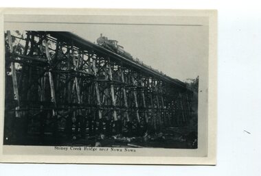
The Stony Creek Trestle Bridge was built in 1916 when the existing rail line from Melbourne to Bairnsdale was extended to Orbost. This 97km Bairnsdale to Orbost extension through rugged terrain was reputed to have been the most difficult rail project undertaken in Victoria. In service for over 60 years the bridge was damaged by bushfire in 1980, with the last train crossing in 1987. At 247m long and 20m high, it is the largest standing bridge of its kind in the State, and is listed on the Register of Historic Sites. Built of red ironbark and grey box timber, it is a fine example of the early engineering skills that utilised the resources and materials found on site.The Bairnsdale to Orbost rail line contains the most varied range of timber & timber composite bridges on any Victorian line. The Stoney Creek bridge is listed on the Victorian Heritage Register for its architectural and historical significance. A black / white photograph of a very tall wooden railway bridge with a train along the top.railway-bridge stoney-creek-bridge east-gippsland-railway -
 Orbost & District Historical Society
black and white photograph, Vogt. W.S, first half 20th century
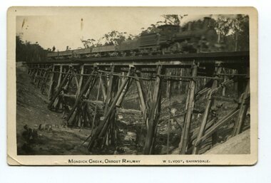
This 97km Bairnsdale to Orbost extension through rugged terrain was reputed to have been the most difficult rail project undertaken in Victoria. This wooden bridge was one of the unique railway bridges of the East Gippsland Railway line. Mundic Creek Bridge is of unique design because the line crosses at a very sharp angle. This bridge like many others on the line have "disappeared". This one, probably because of a bushfire.The Bairnsdale to Orbost rail line contains the most varied range Of timber & timber composite bridges on any Victorian line. This photograph is a record of that. A black / white photograph of a train on a wooden railway bridge at Mundic Creek.on front - Mundic Creek, Orbost Railway W.S.Vogt, Bairnsdalemundic-creek-bridge east-gippsland-railway -
 Orbost & District Historical Society
postcard, Vogt. W.S, first half 20th century
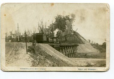
This photograph is of a train on the small rail bridge which crosses over the Burn Road Newmerella cutting. In 1912 work was underway to complete the Bairnsdale to Orbost section of the railway. This meant the end of river transport for the area. The railway was opened on April 10 1916 and closed in 1987. The letter written on the card is from Hilda Graham to her uncle.This item is associated with the history of the Orbost-Bairnsdale railway line and therefore reflects the role that the rail line played in the social and economic history of Orbost.A black / white postcard photograph showing a train engine crossing on a small rail bridge. On the back is a handwritten letter.Photo caption - "NEWMERELLA RAILWAY, ORBOST STANLEY VOGT"newmerella east-gippsland-railway -
 Orbost & District Historical Society
black and white photograph, Vogt. W.S, first half 20th century
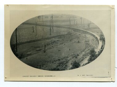
In 1912 work was underrway on the Bairnsdale to Orbost railway. It was opened on April 10 1916. The two bridges on the railway viaduct, which crosses the Snowy River floodplain at Orbost, were built from local Southern Mahogany. The bridge on the Bairnsdale end (770m) is now the longest in Victoria. (info. Helen Martin)This item is associated with the history of the Orbost-Bairnsdale railway line and therefore reflects the role that the rail line played in the social and economic history of Orbost.A black / white photograph, oval-shaped on white background. It is of the railway viaduct across the flats at Orbost,.photo caption -"ORBOST RAILWAY BRIDGE, NEWMERELLA E. S. Vogt, Bairnsdale"newmerella orbost-viaduct east-gipsland-railway -
 Orbost & District Historical Society
black and white photograph, Rose Stereograph Company, first half 20th century
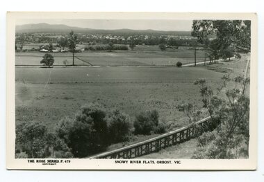
The two bridges on the railway viaduct, which crosses the Snowy River floodplain at Orbost, were built from local Southern Mahogany. The bridge on the Bairnsdale end (770m) is now the longest in Victoria. Despite various attempts to extend the line, the station stayed on the western side of the Snowy River. (info. Helen Martin)This item is associated with the history of the Orbost-Bairnsdale railway line and therefore reflects the role that the rail line played in the social and economic history of Orbost.A black / white photograph / postcard of the Orbost township in the background and the railway viaduct over the flats in the foreground.photo caption - The Rose Series P.479 copywright SNOWY RIVER FLATS, ORBOST, VIC"east-gippsland-railway orbost-viaduct -
 Orbost & District Historical Society
black and white photograph, 1913
This photograph is of the low level bridge across the Bemm River about 50 km east of Orbost in East Gippsland.This is a pictorial record of the 1913 low level bridge across the Bemm River, East Gippsland.A large black / white photograph of a horse - drawn wagon on the low level Bemm River bridge. In the foreground on the bridge is a dog.on back - "Country Roads Board Princes Highway low level bridge" -
 Orbost & District Historical Society
photograph / postcard, early 20th century
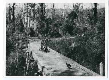
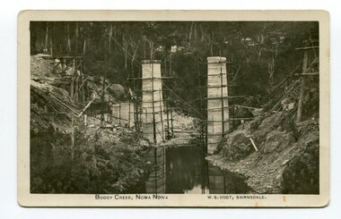
Boggy Creek Bridge was built in 1916 as part of the Bairnsdale to Orbost extension to the main Gippsland Railway, and is situated in the middle of the township of Nowa Nowa, crossing a steep-sided and well-timbered creek-valley. This section of the line closed in 1987.This item is a pictorial record of the construction of the Boggy Creek railway bridge on the East Gippsland line. This bridge plays a major part in the identity and history of the town of Nowa Nowa, since Boggy Creek’s steep sided valley divides the township into two components. A black / white photograph on a postcard showing the construction of a railway bridge across a creek. The end pylons are evident and there is scaffolding on both sides of the creek. Two copies of a black / white photograph showing the construction of a railway bridge across a cree. The end pylons are evident and there is scaffolding on both sides of the creek. There is a steam train on the rail track.on front of postcard - caption - " Boggy Creek, Nowa Nowa, W.S. Vogt, Bairnsdale"boggy-creek-bridge vogt-w.s. railway-bridges east-gippsland-railway railway-construction train -
 Orbost & District Historical Society
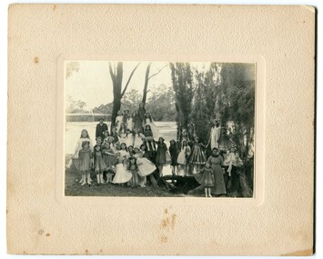
black and white photograph, 1920s
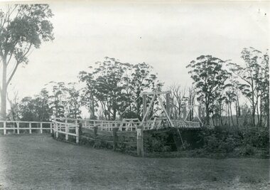
... Orbost & District Historical Society Ruskin Street Orbost ...The bridge shown in the background was built in the 1920s as a road and rail bridge, and was partly washed away by flood waters in 1934. There is no known history of this item.This photograph is a contemporary record of rural life in Orbost in the early 20th century.A black / white photograph of a group of young girls dressed up and posing on the banks of a river. On the left hand side of the photograph is an older man and on the right is an older lady. In the background is a bridge - the first Snowy River bridge. The photograph is on a cream coloured buff card. orbost snowy-river -
 Orbost & District Historical Society
black and white photograph, late 19th century
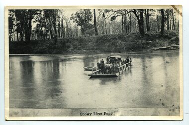
A punt crossed the Snowy River at Orbost from 1884. A bridge was constructed in 1893, but was soon damaged by a huge flood. Flooding was a regular occurrence, the worst inundations being in 1870, 1893, 1925, 1934, 1952 and 1971. Over the years major flood protection works have been implemented. The Princes Highway, which passes Orbost, now crosses the flood plain on raised concrete supports. (info, from Victorian Places Orbost)This item is associated with the Snowy River and its history. It is a pictorial record of transport in the late 19th century.A black / white photograph (copy) of a punt loaded with people and a horse-drawn carriage making its way across a river.on front at bottom - "Snowy River Punt"snowy-river-orbost transport shipping -
 Orbost & District Historical Society
black and white photographs, 1915
This photograph is of the construction of the first road bridge over the Genoa River - 1915. Before today's timber truss and concrete bridge was constructed between 1926-1928 by contractor J.T. Noble Anderson, two earlier bridges crossed the Genoa River at this location. They provided crucial links in the Princes Highway route from Melbourne to Sydney. The letter on the back of the postcard was written by Gordon ? to Alex ? on 2nd October 1917. "this represents the opening of Genoa Bridge. Mrs Alexander cutting the ribbon and Mr Martin holding it at the other side. Did most of the speaking. The gent holding the roll of paper is who came to open the bridge. I can't think of his name. Hubert is standing up at the right / Gordon " This is a pictorial record associated with the history of Genoa in East Gippsland.1100 -A large black / white photograph on a cream coloured buff card. It is of an unfinished bridge with men working there. A small rowboat can be seen on the far side of the river. 1100.1 - A photograph / postcard of the opening of "Genoa Bridge 1917". There is a ribbon stretched across the timber decking road in front of a group of people. 1100.2 - A black / white photograph of a road bridge across a river.on back - "Princes Highway - the 1st bridge over the Genoa River - 1915" on back of 1100.1 is a hand-written letter.genoa-bridge princes-highway-east-gippsland -
 Orbost & District Historical Society
black and white photograph, first half 20th century
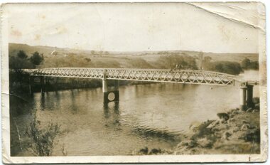
This is the Dalgety bridge across the Snowy River. It is a steel construction.The first bridge over the river was constructed in 1888. There was a punt across the river before the bridge was built . Dalgety is a small service centre, located on the Snowy River approximately 235 km from Orbost. It was an early consideration for the site of Australia,s capital city. The Dalgety Bridge over the Snowy River has been an important item of infrastructure in the history of New South Wales for over 110 years. It was designed by noted bridge engineer J. A. McDonald,and was a technically sophisticated bridge structure for its time. This is a pictorial record of a significant structure on the Snowy River.A small black / white photograph of a large bridge over a river.bridge-dalgety-snowy-river -
 Orbost & District Historical Society
black and white photographs, Howard D. Bulmer, first half 20th century
... Orbost & District Historical Society Ruskin Street Orbost ...This bridge was built in the 1920s as a road and rail bridge, and was partly washed away by flood waters in 1934. After the end of the first World War the Victorian Railways considered an extension of the railhead across the river at Orbost, and in 1922 a new timber and steel girder structure, a joint Country Roads Board — Victorian Railways venture, was built and completed at a cost of £41,000 (the steel girders came from the Flinders Street viaduct reconstruction). Subsequently it was decided not to take the railway across the river, and the bridge has only been used by road traffic. This is a pictorial record of an early bridge across the Snowy River at Orbost.A large black / white photograph of the Orbost Snowy River bridge. There is a large copy as well as a postcard copy in sepia.on front - Snowy River Bridge Orbost H.D. Bulmer - photo - Lake Tyers.snowy-river-bridge-orbost -
 Orbost & District Historical Society
black and white photograph, July 1922
A new bridge over the Snowy River at Orbost was opened for traffic on June 20th 1922. It was designed for future joint use by road and railway traffic, but it was only used for road traffic. During the last few years the condition of an old suspension bridge [the 1893 bridge] which was the only vehicular crossing between the town of Orbost and the railway station, caused much concern. The structure was of timber, except for the wire suspension cables of its central span of about 100 feet. A design was prepared in 1914 for a permanent bridge with five spans of 85 feet composed of plate girders on concrete piers. With great increase in the price of steel work during the war, the cost of this design became prohibitive, and the need for a new structure becoming urgent, alternative proposals were investigated. As a result the present design was adopted as providing a sem-permanent bridge at moderate cost. The new bridge spans the river about 160 feet upstream from the old bridge on a slight skew, the piers being at an angle of 80 degrees with the centre line of the bridge. It has a camber of about 2 feet 5 inches in its total length of 527 feet. ( information from Newsletter March 2014 - Lois Crisp) The photograph shows Mrs James Cameron cutting the ribbon at the opening of the Orbost Pile Bridge in 1922. This second bridge, was built by the Victorian Railways and the Country Roads Board. Constructed at a cost of 35,000 pounds and used second-hand girders from the Flinders Street- Spencer Street viaduct. On July 4 1922 it was officially opened by Mrs James Cameron. Unfortunately, her husband, who had long championed the building of the bridge so that it would be ready for the railway to continue to the border, was too ill to attend the ceremony. In fact, James Cameron died on July 13 after a long and severe illness (ref. S.R.M. 20.7.1922). There is a section of this ribbon in the collection - Registration No. 366. This is a pictorial record of a significant event in Orbost's history.A black / white photograph of a pile bridge with a suspension bridge behind it. There are many people standing on the bridge.on back - "Opening of Pile Bridge - 1922"snowy-river-bridge ceremonies cameron-mrs -
 Orbost & District Historical Society
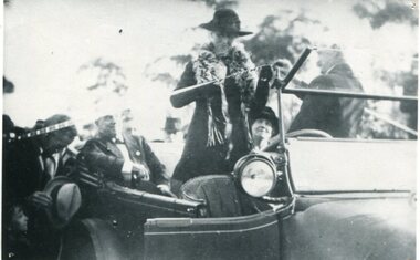
black and white photograph, July 1922
The photograph shows Mrs James Cameron cutting the ribbon at the opening of the Orbost Pile Bridge in 1922. The first bridge was officially opened in August, 1893 (ref. S.R.M. 12.8.1893) by Mrs W. Watt, the mother of Councillor Watt, who presided over the opening of the 1922 bridge. This bridge was extensively damaged when a herd of cattle allegedly stampeded over it causing the cable to snap. Even after repairs it became obvious that a new bridge was needed. This second bridge, was built by the Victorian Railways and the Country Roads Board. Constructed at a cost of 35,000 pounds and used second-hand girders from the Flinders Street- Spencer Street viaduct. On July 4 1922 it was officially opened by Mrs James Cameron. Unfortunately, her husband, who had long championed the building of the bridge so that it would be ready for the railway to continue to the border, was too ill to attend the ceremony. In fact, James Cameron died on July 13 after a long and severe illness (ref. S.R.M. 20.7.1922). There is a section of this ribbon in the collection - Registration No. 366.This item is a pictorial record of a significant event in Orbost's history.A black / white photograph of a lady standing up in a motor vehicle cutting a ceremonial ribbonsnowy-river-bridge-orbost cameron-mrs ceremonies -
 Orbost & District Historical Society
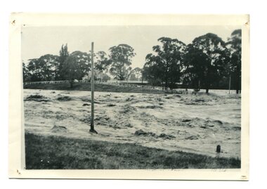
black / white photograph, January 1934
Damage estimated at £500,000 was caused by the 1934 floods in the Orbost district. This 1934 flood was devastating, destroying a section of the 1922 Orbost bridge, wrecking fences, bridges and roads, dumping silt and debris on the rich river flats and drowning cattle. This photograph shows Lochiel Lagoon ( the billabong) in the foreground. Ten minutes after this photograph was taken, the centre span of the Orbost Bridge was washed away.This item is a pictorial record of the 1934 floods, a significant part of Orbost's history.A black / white photograph of swirling floodwaters with township in the background.orbost-floods-1934 natural-disasters-floods -
 Orbost & District Historical Society
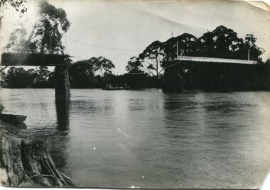
black and white photograph, January 1934
Damage estimated at £500,000 was caused by the 1934 floods in the Orbost district. This 1934 flood was devastating, destroying a section of the 1922 Orbost bridge, wrecking fences, bridges and roads, dumping silt and debris on the rich river flats and drowning cattle. The centre span of the Orbost Bridge was washed away. This item is a pictorial record of the 1934 floods, a significant part of Orbost's history.A black / white photograph showing the flood damage to the Snowy River Bridge. There is a gap in the bridge where the centre span has been washed away. In the background is a punt.orbost-floods-1934 natural-disasters-floods snowy-river-bridge -
 Orbost & District Historical Society
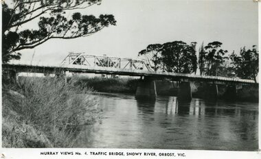
black and white photograph, Murray Studio, Murray Views, 1934
After the flood damage of 1934, the bridge was repaired with a new section in the middle. This bridge remained largely unchanged until its final demolition in 1975 after construction of the new concrete bridge and Orbost by-pass which exists today. This photograph is one of a collection of photographs produced by Murray Views, Gympie. It features eight scenic b/w photographic prints of Orbost and surrounding tourist areas.Photographs like these allowed tourists to send many images of their holiday destination or hometown in the one small package. Fred Murray opened Murray Studios in Gympie in 1906. The postcard and souvenir production side of the business initially covered Gympie and surrounding regions, but Murray expanded the business to include North Queensland, New South Wales and even Adelaide. It was opened under a separate name, Murray Views, in 1929. In 1945 the business was taken over by Murray’s nephews who began postcard folder production. This is a pictorial record of an early bridge across the Snowy River at Orbost.A black / white photograph / postcard of the Snowy River Bridge at Orbost.on front bottom printed - Murray Views No.4 Traffic Bridge , Snowy River, Orbost, Vic.orbost-snowy-river-bridge -
 Orbost & District Historical Society
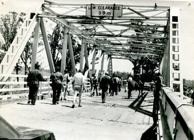
black and white photograph, 1976
... Orbost & District Historical Society Ruskin Street Orbost ...This bridge over the Snowy River was opened on July 4 1922. It was constructed in 1922 alongside the previous suspension bridge. Its building was a combined effort of the Victorian Railways and the Country Roads Board at a cost of 35,000 pounds. It was replaced in 1976 by the present bridge after several major floods. This photograph shows people walking over the bridge for the last time.This is a pictorial record of the former Snowy River Bridge at Orbost.A black / white photograph showing a group of people walking across a bridge. There are several cars, a man on a horse and people standing on the side of the roadway.on back - "1976 - old bridge"snowy-river-bridge-1976