Showing 1700 items
matching norman
-
 Ringwood and District Historical Society
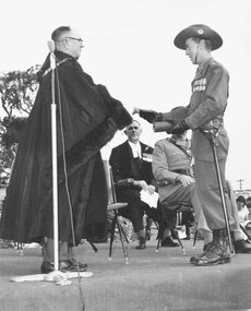
Photograph, Lt. Col Baldwin receiving Freedom of Ringwood City from the Mayor, Cr. B.J. Hubbard - 27 March, 1965. ( 2 photographs)
Typed on back of one photograph, 'Lt. Col Baldwin receiving the key and the certificate of Freedom from the Mayor. Town Clerk, F. Dwerryhouse seated at back. The unit paraded on the reserve at the back of the Town Hall. 27 Mar. 1965'. Written on back of another picture, "Mayor Ben Hubbard handing "Freedom of City" to Capt.. 3rd Div. Engineers'. Last photograph states below it, 'Freedom of the City' on back of same picture, '27th Mar. 65. Mayor (Cr. B.J. Hubbard presenting scroll of Freedom of City to Royal Australian Engineers'. Typed below 11172-2: 1965 Mayor Cr. B. Hubbard presenting scroll qwith Major General His Honour Norman A. Vickery & Major Gen R. J. H. Risson, and handwritten on the reverse: "This is the Scroll presented to the Royal Australian Engineers 3rd Division on 27 March (1965) granting them the freedom of the City of Ringwood. From Left the Mayor of Ringwood (Cr Benjamin Hubbard), The Commander 3rd Division (Major General His Honour Judge Norman A. Vickery) and Major General RJH Risson who represented the Colonel Commandant, Royal Australian Engineers" -
 Phillip Island and District Historical Society Inc.
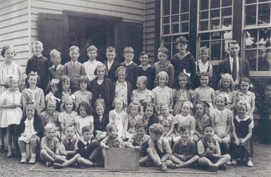
Photograph, Cowes State School, Junior School 1941, 1941
Copy of the original photograph. Original names provided by Betty Bradley. Names were checked by Elly Berryman and her mother, Charlotte Berryman nee Cleeland. 2nd June 2020 Elaine Alexander 4/6/2020Cowes State School No. 1282. (1941). Back Row: Miss Peters, Norman Burton, Neville Cleeland, Bill Davie, Lesley Bain, John Reid, Peter West, Ben Humphries, Alan Cleeland, Kevin Spokes, George Regos, Mr Shaw 2nd Back Row: Isobel Niven, Enid Nelson, Betty Bradley, ??, ??, Heather McLardy, Helen Murdoch, Betty Morrison, Eris Gawith, Fay Schrieber, Lois Barton, ??, Jean Denham. 2nd Front Row: Claire Loton, Charlotte Cleeland, Vivian Cleeland, Marie Regos, Coral McLardy, Shirley Matthews, Dawn Smith, Pat Watchorn, Heather Burton, Ruth Grayden, Deidre Cleeland, Verna Gawith, Pat Smith. Front Row: Gerald Jeffrey, Peter Gerraty, ??, Bill Broadbent, Jim Broadbent, Michael Dixon, Bob Davie, ??. Apologies if names are incorrect or mispelt. Tall boy in back row may be Harry (Peter) Harris.cowes state school 1941, betty bradley -
 Bendigo Historical Society Inc.
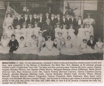
Newspaper - JENNY FOLEY COLLECTION: MINIATURES
Bendigo Advertiser '' The way we were'' from Monday, October 28, 2002. Miniatures: in 1960, 15 mini-debutantes, dressed in white frocks and wearing wristlet posies of pink and blue, were presented to the Bishop of Sandhurst, the Most Rev. B. D. Stewart, at St Liborius' annual children's ball in Eaglehawk Town Hall. The debs and their partners were: Patricia Hill (John Leahy), Pauline Hughes (Bradley Penno), Ann Stewart (Philip Munro), Margaret Benbow (Garry Kallismae), Marie Girvan (Norman Hall), Mary Anderson (Colin Hill), Valerie Andrew (Bernard Crameri), Dianne Crawford (Danny Dullard), Jennifer Newman (Michael Cluff), Carmel McQuillan (Robert Hall), Dorothy Wilson (Shane Metcalf), Rhonda Metcalf (Wayne Fitzgerald), Patricia Fitzpatrick (Mark Gladman), Mary Stack (John Keogh), Elizabeth McCann (Joseph Singe). The clip is in a folder.newspaper, bendigo advertiser, the way we were -
 Bendigo Historical Society Inc.
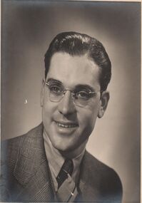
Photograph - NORMAN PENROSE COLLECTION: MALE AND FEMALE PORTRAITS
Photograph. Norman Penrose collection: (A) Photo portrait of a man wearing a suit and tie. He is also wearing glasses, dark hair. (B) Tinted portrait of a lady with black hair. She is wearing a grey dress with beads and fabric flowers and leaves at the shoulders. She is also wearing sun glasses. Picture mounted on cardboard. (C) Black and white portrait of a lady with shoulder length curly hair. She is wearing a black dress. She is also wearing glasses. Portrait mounted with matt board. (D) Coloured portrait of a lady wearing a bright yellow dress with large black buttons at the shoulders. She has short, curly hair. She is wearing glasses which are black with clear lower edges to the frames. Also black ear-rings. The portrait has been taken from the side and she has her head turned to the camera. The background is pale blue.photograph, person, norman penrose collection, artwork, male and female portraits -
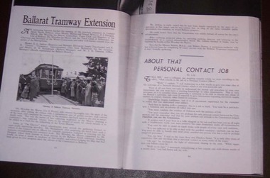 Ballarat Tramway Museum
Document - Photocopy, M. Sayers, "Ballarat Tramway Extension", 2000?
Photocopy of an article in the State Electricity Commission of Victoria Magazine, Contact, Vol 2, No. 3, Nov 1937 titled "Ballarat Tramway Extension". Single A3 sheet. The item details the opening event for the extension of the Lydiard St. tramway to Norman St or Ballarat North, or Lydiard St. North on 30/8/1937. Has a photo of the Mayor, Cr. J. Pryor cutting the ribbon. Gives names of officials who attended or spoke at the function at Electra Hall following the event. Notes the relationship between the SEC and the Council. Included in those who spoke at the event was Robert Haines, Motorman - Conductor "who has achieved fame by completing 50 years service". Record revised 3/4/2019 to add digital images with those from Andrew Cook CD. Each item had a thin strip of paper attached by staple to the top left hand corner, giving the Vol. No. details.trams, tramways, sec, opening, lydiard st north -
 Bendigo Historical Society Inc.
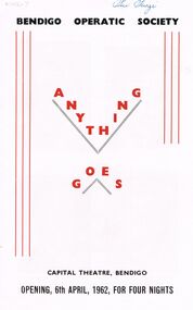
Document - VIKKI SPICER COLLECTION: BENDIGO OPERATIC SOCIETY PROGRAMME BOOKLET, 6th April, 1962
Bendigo Operatic Society Programme Booklet 'Production Ánything Goes Capital Theatre Bendigo Opening, 6th April 1962. For Four Nights. Former Producer The Late Norman Lee, New Producer Miss Beatrice Oakley. Arrangement Samuel French Ltd. Lyrics & Music Cole Porter, Book By P.G. Wodehouse & Guy Bolton. Musical Numbers Include: Ï Get a Kick Out of You' Ýou're the Top', 'There'll Always Be A Lady Fair, 'Ánything Goes' 'Gypsy in Me'' Cast: Denis Cremen, John Stephens, Ferd. Lorenz, Heather Lindhe, Margery Reed, Len Carr, Fred Trewarne, Carol McKenzie, Bernice Boromeo, Max Beckwith, Peter Unmack, Daryl Walker, Ian Beckwith, Rick Perry, Victor White, Roger Sprawson, Roy Cronin, George Steele, Joan Crane, Joan Heard, Alfred Annison, Kath Alexander, Reginald Boromeo, Ray Austin, Peter Houston.Cambridge Press.clubs and associations, theatre, bendigo operatic society, https://en.wikipedia.org/wiki/anything_goes -
 Kew Historical Society Inc
Archive (Sub-series) - Subject File, BRYAN, Cr. Henry & Family, 1958
Various partiesReference, Research, InformationSecondary Values (KHS Imposed Order)Subject file containing genealogical research into the ancestors and descendants of Cr Henry T “Harry” Bryan of 124 Princess Street, Kew. The file also includes a photocopy of the report of the Coronial Inquest into the death by drowning of Cr. Bryan at Parkdale in 1924, photocopied funeral notices, a photograph of the Bryan grave at the Boroondara General Cemetery, a photocopy of the Bryan Family Tree, two letters from Edna Fryer recalling her life in Kew, copies of photographs of Thomas Henry Bryan (1868-1924), John Bryan (1841-1912) and Sarah Bryan nee Chambers (1840-95), Henry Thomas Bryan’s children - Harold George Bryan (1896-1956), John Alfred Edmund Bryan (1897-1984), Norman Arthur Bryan (1898-1964), and Edna May Bryan (1905-1991), copies of the certificates of marriage of John Bryan and Sarah Chambers (1867) and Henry Thomas Bryan and Edith Ripper (1895).bryan family, residents -- families -- kew (vic)bryan family, residents -- families -- kew (vic) -
 Kew Historical Society Inc
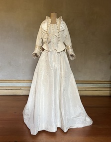
Clothing - Ivory silk and satin wedding dress and jacket, 1876-1944
Alice Henty (1852-1932) was the third daughter of Francis and Mary Ann Henty. her father was the youngest son of Thomas Henty, who with his family, their retainers and property moved to the Australian colonies between 1829 and 1832. In 1834, Francis’ older brother, Edward, sailed from Launceston in Van Diemen’s Land to what was to become Portland in the western part of Port Phillip District [Victoria]. Francis, together with the first flock of Merino sheep [in Victoria], followed some months later. The first and second generations of the Henty family established vast pastoral properties in the Western part of the Port Phillip District. Francis Henty managed ‘Merino Downs’ near Casterton, while also living with his wife following his retirement at ‘Field Place' in Kew. The Henty Collection of nineteenth and twentieth century clothing, including outerwear and underwear, was collected, stored and exhibited over time by female family members descended from Francis and Mary Ann Henty. During the twentieth century, items from the collection were modelled in two fashion parades by various descendants [1937, 1959]. The items in the collection are historically and aesthetically significant, with provenance provided by oral and written tradition within or held by the family. A number of the items in the collection are very rare survivors, and provide researchers with the evidence needed to reconstruct the lives of notable women in the Port Phillip District [later Victoria] during the nineteenth and early twentieth century.Alice Henty’s wedding dress, made in 1876 for her marriage to John Hindson was remodelled in 1943 for the wedding of her granddaughter, Alice Henty Hindson to Norman Lithgow Tait at Holy Trinity, Kew. It was worn again by Margaret Henty Hindson (1918-2000) at her marriage to Dougald Webster Matheson at St Paul's Church, Henty in 1944. The two piece dress has a low décolletage shaped with a collar from which two curved panels drop. The fastenings for the bodice are buttons covered with the same fabric. The bodice is completed with two full length sleeves. The full skirt is slightly flattened at the front with a long train. In contrast, the ivory silk, silk faille and satin bodice with long tails remained unaltered. The front closure of the jacket has handmade embroidered buttonholes and covered buttons. The pleated collar and sleeves are decorated with gathered silk tulle. The jacket features long tails. alice frances (henty) hindson, women's clothing, wedding dresses, margaret henty hindson -
 The Beechworth Burke Museum
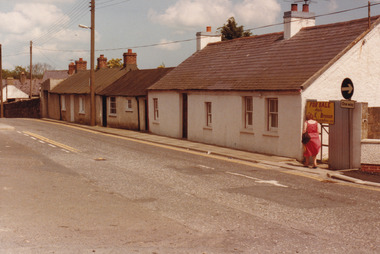
Photograph, 1983
These five images, photographed in 1983, depict locations in Ireland that Ned Kelly's father, John "Red" Kelly may have frequented. John Kelly was born on the 20th of February 1820 and worked as a laborer in Ireland. His parents were named Thomas Kelly and Mary Cody. He had a fresh complexion, large head and reddish coloured hair. John Kelly was sentenced in Tipperary, Ireland for the theft of a pig and received 7 years in Van Diemen's Land (now known as Tasmania). He sailed on the ship "Prince Regent" and arrived in VDL on the 2nd of January 1842 with 11 other convicts. John Kelly completed his sentence and moved to Beveridge in Victoria where he met and married Ellen Quin. The couple had 7 children, one of these is Ned Kelly the Bushranger. He died at the young age 46 in 1866. County Tipperary is a county located in Ireland in the province of Munster. It was established in the early thirteenth century, shortly after the Norman invasion of Ireland. These photographs, taken by an unidentified photographer, show the streetscape of Tipperary, the remains of a coachyard and stables, a saddlery yard and a fashion shop. These images are part of the Burke Museum's Kelly album which are of great use to researchers in the reconstruction of the Kelly story. Images like these, which portray an area which John Kelly resided in his youth, have research potential in reconstructing the conditions and quality of life for the Kelly parent. However, these images are not only important for their connection to the Kelly story but also for what they can provide and reveal for Ireland in the 1980s.A collection of five colour rectangular photographs printed on matte photographic paper10269.1 Reverse: TOWNSEND ST. BANBRIDGE / CO. DOWN N. IRELAND 10269.1 Reverse: TOWNSEND ST. BANBRIDGE / CO. DOWN N. IRELAND 10269.3 Reverse: REMAINS OF COCHYARD AND STABLES / BANBRIDGE CO. DOWN / FREQUENTED BY NED KELLY'S / FATHER 10269.4 Reverse: STABLES AND SADDLERY YARD / THROUGH ENTRANCE FROM / SHOP. PHOTOGRAPH 3 / 10269.5 Reverse: ENTRANCE TO STABLES AND / SADDLERY. FASHION'S SHOP TO LEFT / OF ENTRANCE WAS THE ORIGINAL / SADDLERY SHOP. / BANBRIDGE CO. DOWN / 3kelly album, kelly family, ned kelly, northern ireland, irish heritage, tourism, john kelly, john 'red' kelly -
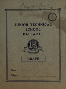 Federation University Historical Collection
Book - Book and loose documents, Ballarat Junior Technical School - Chaplain Fund Donations, 1958; 1959; 1960
In the middle of the 1950s a project was launched to appoint a chaplain to Ballarat's three technical school - Ballarat Junior Technical School, Ballarat Girls' Technical School and Ballarat North Technical School. A Committee was formed at a public meeting on 13 March 1957 - Ballarat Technical Schools Chaplaincy Committee. They needed to raise 1250 Pounds from contributions raised by the schools This was the required amount to pay the annual salary for a chaplain. Response was excellent and in December 1957 a cheque for 1266 Pounds, 4 Shillings and 5 Pence was sent to The Council for Christian Education in Schools. On 28 May 1958, Rev Norman Lee was commissioned as the Chaplain of the Ballarat Technical Schools at a service in the Civic Hall, conducted by the Very Rev, Sir Francis Rolland, with the Director, Major-General A H Ramsay, representing the Education Department. Working over three schools and the need for the Committee to raise 1200 Pounds each year, put a lot of pressure on resources. In 1960 Rev Lee transferred to Nhill and the students of the Central Technical School began attending weekly religious services at the nearby Weslyan Church - now Ballarat Central Uniting Church. .1) School exercise book - graph and lined pages - dated 1957 and 1958. .2) Two (2) individual cards for "Ballarat Technical Schools Chaplaincy Fund" donations - dated 1959. .3) Nine (9) Council for Christian Education in School Receipts addressed to Ballarat Technical Schools Committee - dated 1960. .4) Seven (7) Ballarat Technical Schools Chaplaincy Committee receipts - dated 1959 .5) Six (6) receipts to Ballarat Junior Technical School for funds from The Ballarat Technical School Chaplaincy Committee - dated 1958 .6) Five (5) receipts to Ballarat Junior Technical School for funds from The Ballarat Technical School Chaplaincy Committee - dated 1959 Receipts signed ? Ferguson - Hon. Treasurer of The Ballarat Technical Schools Chaplaincy Committeeballarat junior technical school, ballarat girl's junior technical school, ballarat north junior technical school, chaplain, chaplaincy committee, pounds, shillings, pence, council for christian education in schools, rev. norman lee, very rev, sir francis rolland, major-general ramsay, uniting church, religious services, 1957, 1958, 1959, 1960, weslyan church -
 Ballarat Heritage Services
Photograph - Digital Photograph, St Lawrence Church, Ingworth, England, October 2016
The base of the round tower dates back to the 11th century around the time of the Norman Conquest. It collapsed in 1822. In the 15th century the benches in the south aisle were constructed, originally without backs. The screen now painted brown was painted in colours during the Middle Ages. There is practically no stained glass in this church except for a small Flemish 15th century panel in the east window and a tiny head in the window in the south aisle of the nave. Evidence of the destructive work of the Reformers can be seen on the font where chisel marks can be seen, and the removal of a rood beam or loft. This was reached by a staircase, the remains of which can be seen near the pulpit. The pulpit is part of a 17th century three-decker. The hour glass used to time sermons is still in place near the pulpit. There are a few personal memorials in the church. Ingworth has for centuries been a village run b the people living in it. Many of them now lie in the churchyard, while at least one member of the Harmer family from Baconsthorpe and Ingworth emigrated to Australia, settling in Victoria. Information extracted from booklet researched and written by Valerie Belton.st lawrence church, ingworth, england -
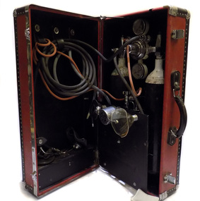 Geoffrey Kaye Museum of Anaesthetic History
Equipment - Resuscitator Unit, c. 1960
Mechanical resuscitation devices, such as the Pulmotor and Lungmotor, were popular in the early part of the twentieth century. Their use waned in the 1920s as significant bodies like the British Medical Research Council and American Red Cross refused to endorse them. The most popular of the resuscitators to emerge in the 1930s was the E&J (Ericson and Johnson) resuscitator. The device was soon widely available, vigorously promoted with support from many medical practitioners. They were soon to be found in hospitals, emergency services like the ambulance and fire brigade, and voluntary life-saving organisations. In Australia, Norman James, director of anaesthesia at the Royal Melbourne Hospital, developed an interest in equipment for ambulances and the resuscitation of drowning victims. Little in the way of practical, portable equipment was available to either the ambulances or the voluntary life-saving organisations, such as Surf Life Saving Australia (SLSA); American resuscitators, like the E&J, were expensive and bulky to import. James designed a simple portable resuscitation device for local use after being approached by Jack Conabere, secretary of the Elwood Life Saving Club (ELSC). The resulting Royal Melbourne Hospital resuscitator, or the R.M. resuscitator as it was marketed, was a simpler, manual version of those available overseas. It was gas driven with a plunger, marked “Press”, and a safety valve. The small working unit attached directly to the facemask. Once the patient was positioned facedown and the airway cleared of debris, the mask was placed firmly over the face. The plunger allowed gas to flow and lung inflation; releasing the plunger allowed expiration. This simple resuscitator was marketed by Commonwealth Industrial Gases (CIG) and became very popular in Australia with volunteer and professional rescue organisations. It represents one of the many innovations in resuscitation equipment that resulted from cooperation between volunteer life savers and medical practitioners. Norman James worked closely with Jack Conabere and the Government Pathologist to develop the equipment. ELSC was the first life saving club to use the resuscitator on the beach. While conducting an early training exercise on 23 December 1951, they used it to successfully resuscitate a man who had drowned after capsizing his home made yacht. The R.M. resuscitator was also used in more inventive ways. At Fairfield Hospital in Melbourne, a group of physiotherapists and doctors did some innovative work with polio patients, teaching them glossopharyngeal (or “frog”) breathing, as a means of becoming less dependent on ventilators. In 1981, the Australian Standards Association stated that the RM head failed to meet its revised standards and it was withdrawn from the market. Red leather suitcase with black leather trim with metal studs. There are clip locks for locking the suitcase in the closed position. The suitcase contains equipment for oxygen resuscitation. There is a space allocated for two oxygen cylinders, however there are no cylinders present.Embossed into metal plaque: The C.I.G. / Oxy-viva / PORTABLE UNIVERSAL OXYGEN RESUSCITATORresuscitation, portable, surf life saving australia, royal melbourne hospital, rm resuscitator -
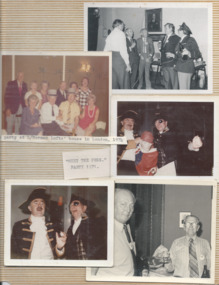 Melbourne Legacy
Photograph - Photo, A record of comradeship activities
A variety of photos from a Comradeship album. The Comradeship committee gathered photos of events and compiled them in a Comradeship photo album for Legatees to look through. 01033.1 A photo of legatees seated around tables. The caption said: L/Donovan Joynt, V.C. at an Anzac party. 01033.2 A page of photos including "Meet the Pres." party in 1971. The photos of Legatees in fancy dress have 23 April 1970 stamped on the back. Also a party at Legatee Norman Lofts' house in London in 1974 and on the back it says Norman was preparing for Ascot June 1974. A legatee at lower right is Howard Hider. 01033.3 A post card of a first world war memorial in Albany WA. 01033.4 A photo of soldiers from the first world war made into a postcard. The names on the photo are L. Liddell, Sgt Harvey Etchins (?), W Brown of the 24th Battalion P__. On the back, handwritten in blue pen, "Yesterday to Day. To Frank from Wal Brown". L Liddell may be David Leslie Liddell, service no 680A (source AWM). Wal Brown may be Walter Charles Brown, Service no 3278 (source AWM). 01033.5-6 Two colour photos of "Meet the Pres. L'tee Bradie Healesville 1974. 01033.7 A black and white photo of Legatees at a table and labelled Anzac Parade 1974. 01033.8 A black and white photo of three Legatees, possibly in fancy dress (cowboy hat, fez). 01033.9-10 Two colour photos of Legatees on the overland train to Perth for the National Conference in 1977, including L/ Frank Doolan, L/ Louis and Amorel Lothian. The other photo is L/s Frank Doolan and Rex Hall sitting together. 01033.11 A colour photo of L/ Rex Hall being awarded first prize for a rendition of Maurice Chevellier "Leetle girls were make to love and kees", in July 1976 - event and venue not known. 01033.12 L/ Rex Hall sitting with Mrs Pat Cahill on the SS Oriana on 10 March 1974. Mrs Cahill was the daughter of David H Dureau whose associate donated funds that enabled the purchase of Legacy House in his memory. 01033.13 L/ Escott in Tewantin Qld in 1986 found an aged care home with his name. The handwriting on the back of the photo pointed out he was not a resident. 01033.14 L/ Escott with Sir Walter Campbell, Governor of Queensland on 11 April 1986 at Government House Qld. 01033.15 The governor of Queensland presenting Legatee Escott with the B.E.M. on 11 April 1986. The items were part of a photo album of Comradeship activities (from 1930 to 1977) see items 01027 to 01036.The Comradeship photo album was put together by the Comradeship committee and records events that Legatees did and places they lived or visited. Some appear to be trips to visit other Legatees living overseas and social occasions held in different places. It shows the bond that Legatees have with each other.Colour photo x 20 from a Comradeship committee photo album.Various labels for the photos.anzac day, comradeship -
 Rutherglen Historical Society
Photograph - Image, 1970s
Greatly relieved by his son’s safe return from war, John Richard Stanton (1872-1955) buys a parcel of productive farming land for his son John Charles “Jack” Stanton (1895-1989) to give him a “good start in life”. Jack’s wife Ethel Capper, devised the name “Gracerray” for the property to honour her sister Grace and the nearby Murray River. After the First World War, fourth generation Jack Stanton (1895-1989) with the help of his father started building a new winery (at the current site of the winery and cellar door) called ‘Gracerray’ named after his wife’s sister Grace and the Murray River. It is pronounced “Grah-sair-ray”. Jack built Gracerray around some existing cement open top vats from a winery that was demolished after phylloxera ravaged the region in the late 1890s. He used second hand materials from the defunct Great Southern gold mine and propped up the roof with huge tree trunks. Jack only made fortified wine up until the 1960s when he and his son-in-law Norman Killeen started making red wine to meet changing Australian tastes.Black and white portrait photograph of a mature man in suit and tie.On back of photo: "145% [upper case E in small circle] J.C. Stanton" wineries, north east victoria, wine industry, j c stanton, stanton & killeen winery, jack stanton -
 Kew Historical Society Inc
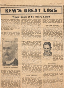
Newspaper - Newspaper Article, Kew's Great Loss, 27/06/1924
Sir Henry de Castres Kellett (1851-1924) the son of a hereditary baronet, was born at Mt Gambier, South Australia in 1851. His English title had been created in Ireland in 1801, but the family was originally Norman with the later branches living in England and Ireland. Sir Henry Kellett assumed the title in 1906. Henry Kellett was a prominent Kew retailer, continuing his father’s newspaper and stationery business in Bulleen Road (now High Street). At various stages, he also acted as an insurance, postal and real estate agent. He lived in Walpole Street and later at Lota Begg (now demolished) in Westbrook Street, East Kew. In 1884, Henry Kellett was elected to the Kew Borough Council and served for 40 years; a remarkable example of public service. He was elected Mayor for a single term in 1888-9. Sir Henry de Castres Kellett died in St George’s Hospital in 1924 following a tragic car accident in Cotham Road, Kew while on Council business. The vehicle, in which he was travelling with fellow councillors and the Town Clerk, collided with a tram. Sir Henry Kellett is commemorated in the naming of Kellett Reserve and Kellett Grove.Newspaper report in The Sentinel reporting the death of Cr Sir Henry Kellett in 1924mayors of kew (vic), sir henry de castres kellett -
 Kew Historical Society Inc
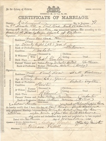
Certificate - Certificate of Marriage, Henry de Castres Kellett & Joan Harrison, 1880, 09/11/1880
Sir Henry de Castres Kellett (1851-1924) the son of a hereditary baronet, was born at Mt Gambier, South Australia in 1851. His English title had been created in Ireland in 1801, but the family was originally Norman with the later branches living in England and Ireland. Sir Henry Kellett assumed the title in 1906. Henry Kellett was a prominent Kew retailer, continuing his father’s newspaper and stationery business in Bulleen Road (now High Street). At various stages, he also acted as an insurance, postal and real estate agent. He lived in Walpole Street and later at Lota Begg (now demolished) in Westbrook Street, East Kew. In 1884, Henry Kellett was elected to the Kew Borough Council and served for 40 years; a remarkable example of public service. He was elected Mayor for a single term in 1888-9. Sir Henry de Castres Kellett died in St George’s Hospital in 1924 following a tragic car accident in Cotham Road, Kew while on Council business. The vehicle, in which he was travelling with fellow councillors and the Town Clerk, collided with a tram. Sir Henry Kellett is commemorated in the naming of Kellett Reserve and Kellett Grove.Original Marriage Certificate of Henry de Castres Kellet and Joan Harrosn, in Richmond on 9 November 1880mayors of kew (vic), sir henry de castres kellett -
 Kew Historical Society Inc
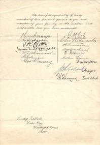
Letter - Letter of Condolence, Lady Kellett, Lota Begg, Westbrook Street, Kew, 1924
Sir Henry de Castres Kellett (1851-1924) the son of a hereditary baronet, was born at Mt Gambier, South Australia in 1851. His English title had been created in Ireland in 1801, but the family was originally Norman with the later branches living in England and Ireland. Sir Henry Kellett assumed the title in 1906. Henry Kellett was a prominent Kew retailer, continuing his father’s newspaper and stationery business in Bulleen Road (now High Street). At various stages, he also acted as an insurance, postal and real estate agent. He lived in Walpole Street and later at Lota Begg (now demolished) in Westbrook Street, East Kew. In 1884, Henry Kellett was elected to the Kew Borough Council and served for 40 years; a remarkable example of public service. He was elected Mayor for a single term in 1888-9. Sir Henry de Castres Kellett died in St George’s Hospital in 1924 following a tragic car accident in Cotham Road, Kew while on Council business. The vehicle, in which he was travelling with fellow councillors and the Town Clerk, collided with a tram. Sir Henry Kellett is commemorated in the naming of Kellett Reserve and Kellett Grove.Original official document from a noted event in Kew's historyOne page undated, handwritten letter of condolence to Lady Kellett on her husband's accidental death in 1924 while serving as a Kew Councillor. The latter is signed by his fellow councillors, the Mayor and the Town Clerkmayors of kew (vic), sir henry de castres kellett -
 Kew Historical Society Inc
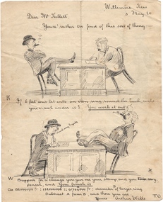
Drawing - Visual Vignettes, Sir Henry de Castres Kellett & Arthur Wills / by Arthur Wills, 1920
Sir Henry de Castres Kellett (1851-1924) the son of a hereditary baronet, was born at Mt Gambier, South Australia in 1851. His English title had been created in Ireland in 1801, but the family was originally Norman with the later branches living in England and Ireland. Sir Henry Kellett assumed the title in 1906. Henry Kellett was a prominent Kew retailer, continuing his father’s newspaper and stationery business in Bulleen Road (now High Street). At various stages, he also acted as an insurance, postal and real estate agent. He lived in Walpole Street and later at Lota Begg (now demolished) in Westbrook Street, East Kew. In 1884, Henry Kellett was elected to the Kew Borough Council and served for 40 years; a remarkable example of public service. He was elected Mayor for a single term in 1888-9. Sir Henry de Castres Kellett died in St George’s Hospital in 1924 following a tragic car accident in Cotham Road, Kew while on Council business. The vehicle, in which he was travelling with fellow councillors and the Town Clerk, collided with a tram. Sir Henry Kellett is commemorated in the naming of Kellett Reserve and Kellett Grove.Original artwork by Arthur Wills, descendent of a noted pioneer family, and former mayor of Kew.Two sided illustrated humorous vignettes featuring two noted Kew citizens: Henry de Castres Kellet and Arthur Wills. The latter is the illustrator. The item was illustrated in 1920.mayors of kew (vic), sir henry de castres kellett, arthur wills, willsmere, wills family -
 Kew Historical Society Inc
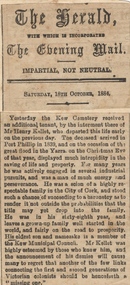
Newspaper - Newspaper Article, Late Sir Henry Kellett, 1924, 1924
Sir Henry de Castres Kellett (1851-1924) the son of a hereditary baronet, was born at Mt Gambier, South Australia in 1851. His English title had been created in Ireland in 1801, but the family was originally Norman with the later branches living in England and Ireland. Sir Henry Kellett assumed the title in 1906. Henry Kellett was a prominent Kew retailer, continuing his father’s newspaper and stationery business in Bulleen Road (now High Street). At various stages, he also acted as an insurance, postal and real estate agent. He lived in Walpole Street and later at Lota Begg (now demolished) in Westbrook Street, East Kew. In 1884, Henry Kellett was elected to the Kew Borough Council and served for 40 years; a remarkable example of public service. He was elected Mayor for a single term in 1888-9. Sir Henry de Castres Kellett died in St George’s Hospital in 1924 following a tragic car accident in Cotham Road, Kew while on Council business. The vehicle, in which he was travelling with fellow councillors and the Town Clerk, collided with a tram. Sir Henry Kellett is commemorated in the naming of Kellett Reserve and Kellett Grove.Newspaper report from 1924, providing an obituary of Sir Henry de Castres Kellettmayors of kew (vic), sir henry de castres kellett -
 Kew Historical Society Inc
Document, Lodge's Peerage, Baronetage, Knightage and Companionage - KELLETT, Sir Henry de Castres Bart
Sir Henry de Castres Kellett (1851-1924) the son of a hereditary baronet, was born at Mt Gambier, South Australia in 1851. His English title had been created in Ireland in 1801, but the family was originally Norman with the later branches living in England and Ireland. Sir Henry Kellett assumed the title in 1906. Henry Kellett was a prominent Kew retailer, continuing his father’s newspaper and stationery business in Bulleen Road (now High Street). At various stages, he also acted as an insurance, postal and real estate agent. He lived in Walpole Street and later at Lota Begg (now demolished) in Westbrook Street, East Kew. In 1884, Henry Kellett was elected to the Kew Borough Council and served for 40 years; a remarkable example of public service. He was elected Mayor for a single term in 1888-9. Sir Henry de Castres Kellett died in St George’s Hospital in 1924 following a tragic car accident in Cotham Road, Kew while on Council business. The vehicle, in which he was travelling with fellow councillors and the Town Clerk, collided with a tram. Sir Henry Kellett is commemorated in the naming of Kellett Reserve and Kellett Grove.Printed extract from Lodge's Peerage, Baronetage, Knightage and Companionage listing KELLETT, Sir Henry de Castres Bart.mayors of kew (vic), sir henry de castres kellett -
 Kew Historical Society Inc
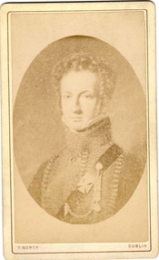
Photograph - Carte de Visite, Captain RJ Napier Kellett, Undated
Sir Henry de Castres Kellett (1851-1924) the son of a hereditary baronet, was born at Mt Gambier, South Australia in 1851. His English title had been created in Ireland in 1801, but the family was originally Norman with the later branches living in England and Ireland. Sir Henry Kellett assumed the title in 1906. Henry Kellett was a prominent Kew retailer, continuing his father’s newspaper and stationery business in Bulleen Road (now High Street). At various stages, he also acted as an insurance, postal and real estate agent. He lived in Walpole Street and later at Lota Begg (now demolished) in Westbrook Street, East Kew. In 1884, Henry Kellett was elected to the Kew Borough Council and served for 40 years; a remarkable example of public service. He was elected Mayor for a single term in 1888-9. Sir Henry de Castres Kellett died in St George’s Hospital in 1924 following a tragic car accident in Cotham Road, Kew while on Council business. The vehicle, in which he was travelling with fellow councillors and the Town Clerk, collided with a tram. Sir Henry Kellett is commemorated in the naming of Kellett Reserve and Kellett Grove.Rare portrait of a Kellett ancestorCarte de Visite of Captain RJ Napier Kellett, an ancestor of Sir Henry de Castres Kellett.CAPN RK NAPIER KELLETT / RIFLE BRIGADE / WATERLOO MEDAL / CAPN ROYAL 42ND HIGHLANDERS THOS NORTH PHOTOGRAPHER / 71 GRAFTON STREET DUBLIN sir henry de castres kellett, cape rj napier kellett, battle of waterloo -
 Kew Historical Society Inc
Newspaper - Newspaper Article, Sir Henry de Castres Kellett - Burial Report, 1924
Sir Henry de Castres Kellett (1851-1924) the son of a hereditary baronet, was born at Mt Gambier, South Australia in 1851. His English title had been created in Ireland in 1801, but the family was originally Norman with the later branches living in England and Ireland. Sir Henry Kellett assumed the title in 1906. Henry Kellett was a prominent Kew retailer, continuing his father’s newspaper and stationery business in Bulleen Road (now High Street). At various stages, he also acted as an insurance, postal and real estate agent. He lived in Walpole Street and later at Lota Begg (now demolished) in Westbrook Street, East Kew. In 1884, Henry Kellett was elected to the Kew Borough Council and served for 40 years; a remarkable example of public service. He was elected Mayor for a single term in 1888-9. Sir Henry de Castres Kellett died in St George’s Hospital in 1924 following a tragic car accident in Cotham Road, Kew while on Council business. The vehicle, in which he was travelling with fellow councillors and the Town Clerk, collided with a tram. Sir Henry Kellett is commemorated in the naming of Kellett Reserve and Kellett Grove.Newspaper report from 1924 of the funeral of Sir Henry de Castres Kellett at Boroondara General Cemeterysir henry de castres kellett -
 Kew Historical Society Inc
Newspaper - Newspaper Article, The Kellett Baronetcy, 1906, 1906
Sir Henry de Castres Kellett (1851-1924) the son of a hereditary baronet, was born at Mt Gambier, South Australia in 1851. His English title had been created in Ireland in 1801, but the family was originally Norman with the later branches living in England and Ireland. Sir Henry Kellett assumed the title in 1906. Henry Kellett was a prominent Kew retailer, continuing his father’s newspaper and stationery business in Bulleen Road (now High Street). At various stages, he also acted as an insurance, postal and real estate agent. He lived in Walpole Street and later at Lota Begg (now demolished) in Westbrook Street, East Kew. In 1884, Henry Kellett was elected to the Kew Borough Council and served for 40 years; a remarkable example of public service. He was elected Mayor for a single term in 1888-9. Sir Henry de Castres Kellett died in St George’s Hospital in 1924 following a tragic car accident in Cotham Road, Kew while on Council business. The vehicle, in which he was travelling with fellow councillors and the Town Clerk, collided with a tram. Sir Henry Kellett is commemorated in the naming of Kellett Reserve and Kellett Grove.Letter to the Editor by Sir Henry de Castres Kellett regarding his Baronetcysir henry de castres kellett, kellett baronetcy -
 Kew Historical Society Inc
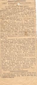
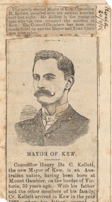
Newspaper - Newspaper Article, Cr Henry Kellett, Mayor of Kew, 1888
Sir Henry de Castres Kellett (1851-1924) the son of a hereditary baronet, was born at Mt Gambier, South Australia in 1851. His English title had been created in Ireland in 1801, but the family was originally Norman with the later branches living in England and Ireland. Sir Henry Kellett assumed the title in 1906. Henry Kellett was a prominent Kew retailer, continuing his father’s newspaper and stationery business in Bulleen Road (now High Street). At various stages, he also acted as an insurance, postal and real estate agent. He lived in Walpole Street and later at Lota Begg (now demolished) in Westbrook Street, East Kew. In 1884, Henry Kellett was elected to the Kew Borough Council and served for 40 years; a remarkable example of public service. He was elected Mayor for a single term in 1888-9. Sir Henry de Castres Kellett died in St George’s Hospital in 1924 following a tragic car accident in Cotham Road, Kew while on Council business. The vehicle, in which he was travelling with fellow councillors and the Town Clerk, collided with a tram. Sir Henry Kellett is commemorated in the naming of Kellett Reserve and Kellett Grove.Illustrated newspaper article from 1888, describing the elevation to the position of mayor of Kew by Cr Henry KellettHERALD 29/8/88sir henry de castres kellett, mayors of kew -
 Kew Historical Society Inc
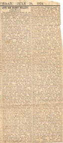
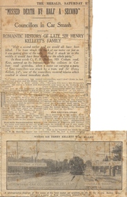
Newspaper - Newspaper Article, Missed Death by Half a Second - Councillors in Car Smash, 1924, 1924
Sir Henry de Castres Kellett (1851-1924) the son of a hereditary baronet, was born at Mt Gambier, South Australia in 1851. His English title had been created in Ireland in 1801, but the family was originally Norman with the later branches living in England and Ireland. Sir Henry Kellett assumed the title in 1906. Henry Kellett was a prominent Kew retailer, continuing his father’s newspaper and stationery business in Bulleen Road (now High Street). At various stages, he also acted as an insurance, postal and real estate agent. He lived in Walpole Street and later at Lota Begg (now demolished) in Westbrook Street, East Kew. In 1884, Henry Kellett was elected to the Kew Borough Council and served for 40 years; a remarkable example of public service. He was elected Mayor for a single term in 1888-9. Sir Henry de Castres Kellett died in St George’s Hospital in 1924 following a tragic car accident in Cotham Road, Kew while on Council business. The vehicle, in which he was travelling with fellow councillors and the Town Clerk, collided with a tram. Sir Henry Kellett is commemorated in the naming of Kellett Reserve and Kellett Grove.Illustrated newspaper article from 1924, describing the death of Cr Henry Kellettsir henry de castres kellett -
 Surrey Hills Historical Society Collection
Photograph, Mrs Blanche Cornell
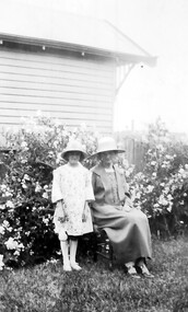
Mrs Blanche Cornell, wife of Frank Cornell, at the beach with 2 of her children, ? c1905 Frank Cornell was first listed in Surrey Hills in 1906 at (6) Lorne Parade. In 1908 the listing gives his occupation as a clerk. He was born in 1869 in Richmond, Victoria and died 15 April 1917 in Surrey Hills. Blanche Annie Parsons Cornell (nee Bracher) was born in 1869 in Hokitika, New Zealand; she died on 21 January 1940. Children were: Gilbert Frank Cornell (b1894, Hawthorn; d1908, at Frankston beach, an accidental drowning) Ruth Amelia Cornell (b 1899, Kew; d 29 May 1977, Kew) Lorna Amy Cornell (b 1906, Surrey Hills; d unknown) Patience Blanche Cornell (b1907, Surrey Hills; d unknown. Frank and wife Blanche are buried in Box Hill Cemetery - CE-*-1058. Ruth Amelia married David Ellis, c1922 in Surrey Hills. David was a dentist who practised in Surrey Hills for many years. Patience (Pat) Blanche married Norman Henry Brewer (1893–1975) in 1931 in Surrey Hills. Given the children's dates of birth, it is likely that it is Gilbert and Ruth in the photo. A black and white photograph of a lady dressed in an ankle length skirt, long sleeved blouse and wearing a hat. She is sitting on the beach and drying off one small girl. There is another small girl or boy to the left of the lady.clothing and dress, 1908, (mrs) blanche cornell, beach, (mrs) blanche annie parsons cornell, (miss) blanche annie parsons bracher, box hill cemetery -
 Surrey Hills Historical Society Collection
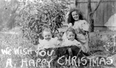
Photograph, Ruth, Lorna and Patience Cornell at Christmas, c1907
Children of Mr & Mrs Frank Cornell of 4-8 Lorne Parade. Frank Cornell was first listed in Surrey Hills in 1906 at (6) Lorne Parade. In 1908 the listing gives his occupation as a clerk. He was born in 1869 in Richmond, Victoria and died 15 April 1917 in Surrey Hills. Blanche Annie Parsons Cornell (nee Bracher) was born in 1869 in Hokitika, New Zealand; she died on 21 January 1940. Children were: Gilbert Frank Cornell (b1894, Hawthorn; d1908, at Frankston beach, an accidental drowning) Ruth Amelia Cornell (b 1899, Kew; d 29 May 1977, Kew) Lorna Amy Cornell (b 1906, Surrey Hills; d unknown) Patience Blanche Cornell (b1907, Surrey Hills; d unknown. Frank and wife Blanche are buried in Box Hill Cemetery - CE-*-1058. Ruth Amelia married David Ellis, c1922 in Surrey Hills. David was a dentist who practised in Surrey Hills for many years; practice located in Windsor Crescent. . Patience (Pat) Blanche married Norman Henry Brewer (1893–1975) in 1931 in Surrey Hills. The photo appears to be of the 3 girls. A black and white photograph of three children, two of whom are sitting in a wooden wheelbarrow. The image has a message "We wish you a happy Christmas" printed at the bottom of the card.(mr) frank cornell, (mr) (dr) david ellis, (miss) ruth cornell, surrey hills, windsor crescent, lorne parade, (miss) lorna cornell, (miss) patience cornell, christmas, (mrs) blanche annie parsons cornell -
 Surrey Hills Historical Society Collection
Photograph, Mary Sneddon with daughter Jean
The photo was taken in the garden of of 'Cliburn', 14 Suffolk Avenue, Surrey Hills, the home of William and Mary (nee Bird) Sneddon. It was named after Cliburn, Westmorland (later Cumbria) where Mary's mother was born and the name was given to all their homes. Mary Bird, daughter of John Bird and Mary Coulston, b 1878 Bethanga, Victoria; died 1948, Surrey Hills. They were married on 12/11/1903 in Surrey Hills at the home of James Sneddon. William Sneddon was a postman in Surrey Hills for many years. His father James had an estate agency in Surrey Hills from the 1880s. Born in1875, Sandhurst (Bendigo); died in 1957, Deepdene. Buried Box Hill Cemetery: P-061-0033. They had the following children: Jim (James 3rd) b 1905, Balwyn Jack (John William) b. 1908, Camberwell Norman Alexander b 1910, Camberwell Alan Coulson b 1914 Surrey Hills Jean Isabel b 1916, Surrey Hills Douglas Haig b 1918, Surrey Hills. Additional information from Robin da Costa-Adams, who is related to the Sneddon family through her first marriage. Sepia photo of Mary Sneddon with daughter Jean wearing hats and taken in a garden. Mary is seated and Jean stands beside her. Part of the house next door can be seen in the background. It is an Edwardian timber home"Jean Sneddon / Mary Sneddon/ (in grey lead pencil by Robin da Costa-Adams. 1050 in blue biro crossed out in top RH corner. KODAK PRINT - black stamp in centre. "Jean dau of Mary - / Will. Sneddon" in black ink in Jocelyn Hall's hand. cliburn, suffolk road, (miss) jean sneddon, william sneddon, (mrs) mary sneddon, (miss) mary bird -
 Vision Australia
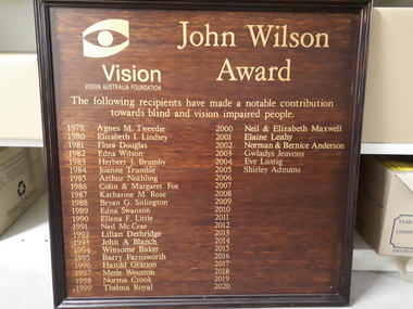
Photograph - Image, John Wilson Award
From 1979, the John Wilson Award was awarded to individuals who made a significant difference to the lives of those around them. To publicly acknowledge this, a signboard was established and hung at the Kooyong Centre. The top of the board was inscribed with the words 'Vision Australia Foundation' and the eye logo is located in the top left-hand corner. Below this is written: "The following recipients have made a notable contribution towards blind and vision impaired people. 1979 Agnes M. Tweedie, 1980 Elizabeth I. Lindsay, 1981 Flora Douglas, 1982 Edna Wilson, 1983 Herbert J. Brumby, 1984 Joanne Trumble, 1985 Arthur Nothling, 1986 Colin & Margaret Fox, 1987 Katharine M. Rose, 1988 Bryan G. Sitlington, 1989 Edna Swanson, 1990 Ellena F. Little, 1991 Neil McCrae, 1992 Lillian Dethridge, 1993 John A. Blanch, 1994 Winsome Baker, 1995 Barry Farnsworth, 1996 Harold Gration, 1997 Merle Wootten, 1998 Norma Crook, 1999 Thelma Royal, 2000 Neil & Elizabeth Maxwell, 2001 Elaine Leahy, 2002 Norman & Bernice Anderson, 2003 Gwladys Jeavons, 2004 Eve Lustig, 2005 Shirley Admans.Wooden board with frame and gold letteringawards, vision australia foundation, association for the blind -
 Federation University Historical Collection
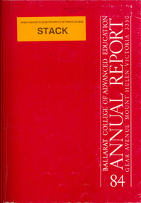
Book, Ballarat College of Advanced Education Annual Report, 1984, 1985
Council President for 1985 was E.T. OppyRed soft covered book. Contents include: health Education, Future of Diploma Courses, Psychology, Ian Anderson, Peter Swan, Alan Roberts, Judy Charlton, Lorraine brilla, Gary Goran, Graham Holmes, Jenny turner, John Howard, John Siddons, Clive Bibb, Jim Short, Marjorie Sergeant, Dorothy Crocker, Robert Macgowan, Margaret Bowman, John Burrell, Fazal Rizvi, Roger Slee, Norman Barling, Barry Fitzgerald, Clem Barnett, Peter Coman, Ray Watson, Phil Smith, Lindsay Pattenden, Robert Anderson, Keith Llewellyn, Ron Hateley, Peter Middlebrook, Stafford McKnight, Gil Medwell, Bill Durant Memorial Youth Lecture, A. Phillip, retirement of Geoff Biddington, Bill Rofe, John Brown, Les McGrath, staff appointment of Dennis Else, Trevor Gourlay, Clive Ferguson, Russell McKenzie, Rhonda McSwain, Kay kent, mary russell, library, student residences, death of Marion Holgateballarat college of advanced education, bcae, mt helen, mount helen, oppy, pell, george pell, boyce, taylor, hlomes, ed oppy, e.t. oppy