Showing 17710 items matching "b-52"
-
 Clunes Museum
Document - ARCHITECTURAL DRAWINGS, CLUNES WATER SUPPLY
CLUNES WATER SUPPLY .1 DRAWING No 21 (CHANGED TO 11). LOWER WEIR. DETAILS OF MASONRY - DESIGN B .2 DRAWING No 5 CONTRACT No 2. LONGITUDINAL SECTION OF CENTRE LINE OF LOWER AQUEDUCT FROM WEIR A TO SERVICE RESERVOIR .3 DESIGNS FOR WEIRS - CROSS SECTION OF THE BED OF THE CREEK SHOWING WEIR STRUCTURE. .4 DRAWING No 11. LONGITUDINAL SECTION - PROPOSED LINE OF PIPES No 1 RESERVOIR. .5 DRAWING No 17 SECTIONS. HANDWRITTEN. .6 DRAWING No 5. PLAN OF LINE OF PIPES No 1 RESERVOIR..2 HANDWRITTEN NOTES ON REAR IN PENCILclunes, water supply, drawings -
 Eltham District Historical Society Inc
Photograph - Aerial Photograph, Landata, Eltham, Vic, Jan. 1951
Centred on Allison Crecent Reserve, Sherbrook Road and Scenic Crescent, Eltham bounded by Allendale Road to north, Dudley Street to south, Zig Zag Road to east and St Helena Road to west. Historic Aerial Imagery Source: Landata.vic.gov.au Aerial Photo Details: Project No :65 Project : MELBOURNE AND METROPOLITAN PROJECT NO. 2 Run : 7 Frame : 10 Date : 01/1951 Film Type : B/W Camera : EAG9 Flying Height : 12200 Scale : 12000 Film Number : 1419 GDA2020 : 37°42'14"S, 145°08'36"E MGA2020 : 336339, 5825416 (55) Melways : 21 H2 (ed. 42)Historical aerial photos and photo maps provide viusal evidence of the chronology of changes to the built landscape of the district and assist in dating other imagesaerial photo, 1951-01, eltham, neil webster collection, allendale road, allison crecent reserve, dudley street, melway 21h2, scenic crescent, sherbrook road, st helena road, zig zag road -
 Eltham District Historical Society Inc
Photograph - Aerial Photograph, Landata, Montmorency, Feb. 1956
Centred on present day Grand Boulevard and Olympic Way, Montmorency bounded by Diamond Street to north, Old Eltham Road and Eltham Lower Park to south, Bible Street to east and Para Road to west. Historic Aerial Imagery Source: Landata.vic.gov.au Aerial Photo Details: Project No :250 Project : MELBOURNE OUTER SUBURBS PROJECT Run : 17 Frame : 115 Date : 02/1956 Film Type : B/W Camera : EAG9 Flying Height : 10000 Scale : 12000 Film Number : 1176 GDA2020 : 37°43'24"S, 145°07'55"E MGA2020 : 335375, 5823236 (55) Melways : 21 F7 (ed. 42)aerial photo, 1956-02, neil webster collection, eltham, main road, montmorency, bible street, diamond street, eltham lower park, grand boulevard, melway 21f7, old eltham road, olympic way, para road -
 Eltham District Historical Society Inc
Photograph - Aerial Photograph, Landata, Eltham, Feb. 1956
Centred on present day Mount Plaeasant Road near Dalton Street, Eltham bounded by Luck Street to north, Eltham Lower Park to south, Reynolds Road to east and Central Park to west Historic Aerial Imagery Source: Landata.vic.gov.au Aerial Photo Details: Project No :250 Project : MELBOURNE OUTER SUBURBS PROJECT Run : 18 Frame : 93 Date : 02/1956 Film Type : B/W Camera : EAG9 Flying Height : 10000 Scale : 12000 Film Number : 1176 GDA2020 : 37°43'02"S, 145°09'38"E MGA2020 : 337871, 5823961 (55) Melways : 22 B6 (ed. 42)aerial photo, 1956-02, neil webster collection, eltham, central park, eltham lower park, luck street, melway 22b6, nyora road, reynolds road, dalton street, mount pleasant road -
 Eltham District Historical Society Inc
Photograph - Aerial Photograph, Landata, Eltham, Vic, Feb. 1956
Centred on present day Parsons Avenue at Leane Drive near the Maroondah Aqueduct, Eltham bounded by Lorimer Road to north, Thompson Crescent and Norman Road to south, Bells Hill Road to east and Parsons Road to west Historic Aerial Imagery Source: Landata.vic.gov.au Aerial Photo Details: Project No :250 Project : MELBOURNE OUTER SUBURBS PROJECT Run : 19 Frame : 5 Date : 02/1956 Film Type : B/W Camera : EAG9 Flying Height : 10000 Scale : 12000 Film Number : 1176 GDA2020 : 37°42'04"S, 145°11'09"E MGA2020 : 340064, 5825786 (55) Melways : 22 H1 (ed. 42)aerial photo, 1956-02, neil webster collection, allendale road, bells hill road, eltham, leane drive, lorimer road, maroondah aqueduct, melway 22h1, norman road, parsons road, research (vic.), thompson crescent -
 Eltham District Historical Society Inc
Photograph - Aerial Photograph, Landata, Eltham, Vic, Apr. 1963
Centred on present day Zig Zag Road and Main Road, Eltham bounded by Maroondah Aqueduct to north, Thompson Crescent and Arthur Street to south, Parsons Road to east and Glen Park Road and Banks Road to west. Historic Aerial Imagery Source: Landata.vic.gov.au Aerial Photo Details: Project No :486 Project : MELBOURNE (1963) PROJECT Run : 5 Frame : 59 Date : 04/1963 Film Type : B/W Camera : RC8 Flying Height : 5100 Scale : 9600 Film Number : 1805 GDA2020 : 37°42'24"S, 145°08'52"E MGA2020 : 336716, 5825114 (55) Melways : 21 J3 (ed. 42)aerial photo, neil webster collection, eltham, 1963-04, arthur street, banks road, glen park road, maroondah aqueduct, melway 21j3, parsons road -
 Eltham District Historical Society Inc
Photograph - Aerial Photograph, Landata, Eltham, Vic, Apr. 1963
Centred on present day Floriston Grove, Eltham bounded by Maroondah Aqueduct to north, Thompson Crescent and Diosma Road to south, Research Shops to east and Glen Park Road and Park West Road to west. Historic Aerial Imagery Source: Landata.vic.gov.au Aerial Photo Details: Project No :486 Project : MELBOURNE (1963) PROJECT Run : 5 Frame : 60 Date : 04/1963 Film Type : B/W Camera : RC8 Flying Height : 5100 Scale : 9600 Film Number : 1805 GDA2020 : 37°42'24"S, 145°09'29"E MGA2020 : 337622, 5825128 (55) Melways : 22 B3 (ed. 42)aerial photo, neil webster collection, eltham, 1963-04, diosma road, floriston grove, maroondah aqueduct, melway 22b3, park west road, research (vic.), research shops -
 Eltham District Historical Society Inc
Photograph - Aerial Photograph, Landata, Lower Plenty, Vic, Apr. 1963
Centred on present day Old Eltham Road near Araluen Centre, Lower Plenty bounded by Cromwell Street to north, Yarra River to south, Main Road at Mount Pleasant Road to east and Panorama Avenue to west. Historic Aerial Imagery Source: Landata.vic.gov.au Aerial Photo Details: Project No :486 Project : MELBOURNE (1963) PROJECT Run : 7 Frame : 231 Date : 04/1963 Film Type : B/W Camera : RC8 Flying Height : 5100 Scale : 9600 Film Number : 1805 GDA2020 : 37°44'03"S, 145°07'56"E MGA2020 : 335420, 5822027 (55) Melways : 21 F10 (ed. 42)aerial photo, neil webster collection, 1963-04, araluen, cromwell street, eltham, lower plenty, main road, melway 21f10, mount pleasant road, old eltham road, panorama avenue, yarra river -
 Eltham District Historical Society Inc
Photograph - Aerial Photograph, Landata, Eltham, Vic, Apr. 1963
Centred on present day Eltham Lower Park bounded by Brougham Street to north, Yarra River and Fitzsimons Lane Bridge to south, Main Road at Kent Hughes Road to east and Bolton Street to west. Historic Aerial Imagery Source: Landata.vic.gov.au Aerial Photo Details: Project No :486 Project : MELBOURNE (1963) PROJECT Run : 7 Frame : 232 Date : 04/1963 Film Type : B/W Camera : RC8 Flying Height : 5100 Scale : 9600 Film Number : 1805 GDA2020 : 37°44'03"S, 145°08'33"E MGA2020 : 336329, 5822040 (55) Melways : 21 H10 (ed. 42)aerial photo, neil webster collection, 1963-04, bolton steet, brougham steet, eltham, eltham lower park, fitzsimons lane bridge, kent hughes road, melway 21h10, yarra river -
 Eltham District Historical Society Inc
Photograph - Aerial Photograph, Landata, Eltham North, Vic, Apr. 1972
Centred on present day Eltham North reserve near Eltham North Primary School, Eltham North bounded by Allendale Road to north, Bellevue Road to south, Zig Zag Road and Beard Street to east and Ryans Road to west. Historic Aerial Imagery Source: Landata.vic.gov.au Aerial Photo Details: Project No :985 Project : MELBOURNE 1972 Run : 26 Frame : 190 Date : 04/1972 Film Type : B/W Camera : RC10 Flying Height : 5700 Scale : 9600 Film Number : 2636 GDA2020 : 37°41'52"S, 145°08'52"E MGA2020 : 336705, 5826102 (55) Melways : 11 J12 (ed. 42)aerial photo, neil webster collection, 1972-04, allendale road, beard street, bellevue road, eltham, eltham north, eltham north reserve, melway 11j12, ryans road, zig zag road, eltham north primary school -
 Eltham District Historical Society Inc
Photograph - Aerial Photograph, Landata, Research, Vic, Apr. 1972
Centred on present day Main Road, Research near Maroondah Aqueduct and Eltham College bounded by Allendale Road to north, Research-Warrandyte Road to south, Swipers Gully Training Restaurant to east and Reynolds Road to west. Historic Aerial Imagery Source: Landata.vic.gov.au Aerial Photo Details: Project No :985 Project : MELBOURNE 1972 Run : 26 Frame : 194 Date : 04/1972 Film Type : B/W Camera : RC10 Flying Height : 5700 Scale : 9600 Film Number : 2636 GDA2020 : 37°42'07"S, 145°11'07"E MGA2020 : 340015, 5825692 (55) Melways : 22 H1 (ed. 42)aerial photo, neil webster collection, 1972-04, allendale road, eltham college, main road, maroondah aqueduct, melway 22h1, research (vic.), research-warrandyte road, reynolds road, swiper's gully -
 Eltham District Historical Society Inc
Photograph - Aerial Photograph, Landata, Eltham, Vic, Apr. 1972
Centred on present day Diamond Creek Trail at the Eltham Leisure Centre bounded by Central Park to north, Main Road at Falkiner Street to south, MacMahon Ball Paddock to east and Grand Boulevard at Buena Vista Drive to west. Historic Aerial Imagery Source: Landata.vic.gov.au Aerial Photo Details: Project No :985 Project : MELBOURNE 1972 Run : 28 Frame : 207 Date : 04/1972 Film Type : B/W Camera : RC10 Flying Height : 5700 Scale : 9600 Film Number : 2635 GDA2020 : 37°43'25"S, 145°08'20"E MGA2020 : 335985, 5823223 (55) Melways : 21 G7 (ed. 42)aerial photo, neil webster collection, 1972-04, eltham, buena vista drive, central park, diamond creek trail, eltham leisure centre, falkiner street, grand boulevard, macmahon ball paddock, main road, melway 21g7 -
 Eltham District Historical Society Inc
Photograph - Aerial Photograph, Landata, Eltham, Main Road; Mt Pleasant Rd to Railway Rd, Dec. 1945
Centred on Main Rd and Henry St, Eltham bounded by Railway Road to north, Mount Pleasant Road at Main Road to south, top of the hill in Arthur Street to east and Karingal Drive at Sherbourne Road to west. Historic Aerial Imagery Source: Landata.vic.gov.au Aerial Photo Details: Project No :65 Project : MELBOURNE AND METROPOLITAN PROJECT NO. 2 Run : 8 Frame : 70 Date : 01/1951 Film Type : B/W Camera : EAG9 Flying Height : 12200 Scale : 12000 Film Number : 1419 GDA2020 : 37°43'06"S, 145°08'45"E MGA2020 : 336589, 5823811 (55) Melways : 21 J6 (ed. 42)aerial photo, eltham, main road, henry street, arthur street, bolton street, eltham-yarra glen road, neil webster collection, 1951-01, dave lyon house, ernie andrew house, karingal road, melway 21j6, mount pleasant road, railway road -
Glen Eira Historical Society
Document - Leuba, Cecile
Three items about Cecile Leuba and her family. Photocopied article taken from ‘From Jolimont to Yering-Yarra wine- Two Centuries’ by Raymond Henderson 2006. The article mentions Sam and Cecile Leuba, and their return to Melbourne from Switzerland and their subsequent decision to rent accommodation at “Aldgate”, Caulfield, 1914 to 1920. Photocopied article, death notice for Bert Parkinson, inserted by Florence Leuba ‘of Aldgate’ Kooyong Road, Caulfield, dated 1917. Hand written research by Claire Barton 23/03/2013, from (a) book ‘From Jolimont to Yering-Yarra Wine- Two centuries’ and (b) Argus newspaper circa 05/05/1917.leuba sam, leuba cecile, pioneers, leuba emma, hebenstrait hans, ‘aldgate’, caulfield, house names, kooyong road, leuba florence, luba madeline, lueba berthe, leuba anna, parkinson bert, parkinson albert e -
 Glen Eira Historical Society
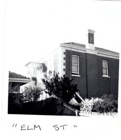
Article - Elm Avenue, 21, Elsternwick
1/One small black and white photograph of the residential property in 21 Elm Avenue. 2/Two advertisements for the sale of Flat 3, 21 Elm Avenue from unknown publications dated 07/03/2006 and 14/03/2006. The auction was to be held on 01/04/2006. Includes two exterior and one interior photograph Recent sale notice of 2/21 Elm Avenue dated 2013. Includes colour exterior photograph 4/Copy of letter dated 17/02/1998 from Heritage Victoria to J and B Chi Lok Wong, owners of 21 Elm Avenue, concerning nomination of the property for the Heritage Registerelm avenue, elsternwick, chimneys, brick houses, victorian style, architectural styles, architectural features, flats, hopetoun street, walton manor -
 Eltham District Historical Society Inc
Photograph, N. J. Tillings Timber Factory, 15 June, 1975, 15/06/1975
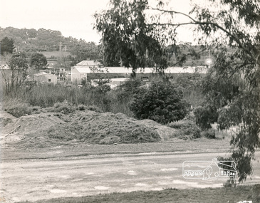
Edge of brick building part of the light industrial area including N. J. Tillings Timber Factory, Brougham Street, Eltham. This is one of 7 B/W 8x10 inch photos with notes on back by Dick Crichton. Accompanying letter from Florence Chrichton 2013 : "Originally sent to Shire of Eltham Engineer, Mr. McDonald. [These photographs were part of their campaign to the Shire of Eltham in 1975] claiming that the zoning regulations were being breached by the occupants of various factories in the nearby light industrial zone [Brougham Street, Eltham] - to the detriment of those living in adjoining residential zones, and that, despite .. earlier objections and complaints, nothing was done about it." 1 black and white photograph printed with white border on three sidesindustrial estate, brougham street, eltham, 1975, bolton street, dick crichton, n.j. tillings, timber factory, shire of eltham -
 Eltham District Historical Society Inc
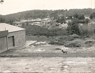
Photograph, N. J. Tillings Timber Factory, 15 June, 1975, 15/06/1975
Piles of dirt alongside dirt road, part of the light industrial area including N. J. Tillings Timber Factory, Brougham Street, Eltham. This is one of 7 B/W 8x10 inch photos with notes on obverse by Dick Crichton. Accompanying letter from Florence Chrichton 2013 : "Originally sent to Shire of Eltham Engineer, Mr. McDonald. [These photographs were part of their campaign to the Shire of Eltham in 1975] claiming that the zoning regulations were being breached by the occupants of various factories in the nearby light industrial zone [Brougham Street, Eltham] - to the detriment of those living in adjoining residential zones, and that, despite .. earlier objections and complaints, nothing was done about it." 1 black and white photograph printed with white border on three sidesInscribed on back: "View from residential premises in Brougham Street. Trees in foreground will soon be lost due to making of the main drain by M.M.B.W.. Photograph shows topographical features of the valley and how sound travels upwards and outwards to residential zones surrounding." industrial estate, brougham street, eltham, 1975, bolton street, dick crichton, n.j. tillings, timber factory, shire of eltham -
 Orbost & District Historical Society
black and white photographs, 1939
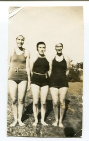
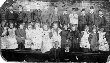
These are photographs of students who participated in The Orbost High School Swimming Carnival in 1939. 3181.1 is of the winners in the Senior Breast Stroke. Included are R. Russell (3rd place); P. Gall (2nd place) and B. Russell (1st place). 3181.2 is of the winners of the Junior Dive. In the photograph are: Ray Russell (1st); Dot Lynn (2nd). 3181.3 has five girls who were members of Rowe A Team, the winning bteam. The girls are: M. Robinson; Ray Robinson; M. Herbert; P. Gall; Nance Gilbert. 3181.4 is of three place-getters in the Junior Freestyle. They were: Marion Herbert (1st); Annette D, (2nd) and Ray Russell (3rd)Orbost High School / Orbost Secondary College has played a significant part in the education of senior students in the Orbost district . It is the sole senior educational institution. These photographs are representative of its history.Four small black / white photographs of girls wearing swimming costumes. orbost-high-school swimming school-sports recreation-swimming -
 City of Moorabbin Historical Society (Operating the Box Cottage Museum)
Photograph - Two Photos of pupils at Bentleigh State School, East Bentleigh, 1895
Photo 1: Circa 1895: Pupils at East Bentleigh State School. Located close to Cnr. of Tucker and Centre Rds, East Bentleigh. Demolished c 1990. Pupil, Elizabeth Ann Jones, (Mrs Kennedy) B.1884- D 1979 is marked with a cross. The Jones and Kennedy families were early settlers in the Moorabbin Shire. Photo 2: Circa 1895: Pupils at East Bentleigh State School with a football. The very poor condition of these "restored" photographs indicates their great age, and deterioration that occurred prior to the Moorabbin Historical Society receiving them. Unfortunately, no further improvement is possible. The original photographs are held on file at the CM.H.S. Box Cottage Museum.2 x black and white Photographs. The photos are in poor condition and have been re stored. The first photo is a group of pupils, standing and sitting in a line having a class photo taken. Due to the deterioration of the photograph, some of the pupils are not clearly seen. The class is a mix of young boys and girls. The girl third from left, front is marked with a cross and named Ellzabeth Ann Jones 1884 - 1979, a relative of Mr James Jones and Mr John Herron, who became Mrs Kennedy. Second photograph is also a group photo of young male pupils from the East Bentleigh State School. Again it is a poor quality photo and some of the pupils are difficult to see. pupils, bentleigh state school, east bentleigh, moorabbin, football, 1895, jones james , jones. elizabeth ann, jones martha, kennedy john, herron john, market gardeners, pioneers, early settlers, moorabin, bentleigh, brighton, henry dendy's special survey 1841, state schools, australian rules football, students, teachers, education, -
Mount Evelyn History Group
Book Railways of the Yarra Valley, Nick Anchen, Railways of the Yarra Valley, 2010
Railways of the Yarra Valley takes you on a nostalgic journey back in time to when the Victorian Railways branch lines and the ingenious bush tramways were the lifeblood of isolated rural communities. This book examines the much loved Warburton and Healesville railways, along with the fascinating Powelltown, Britannia Creek and Warburton tramway systems, all of which were instrumental in making the Yarra Valley Victoria�s most prosperous timber region. Featuring a superb array of colour and b&w images, most never before published, complimented by interesting and informative text, plus stories from those who saw and worked the lines. Soft bound, 96 pages. (from website)Coloured cover soft back book -
Mount Evelyn History Group
Book Railways of the Yarra Valley, Nick Anchen, Railways of the Yarra Valley, 2010
Railways of the Yarra Valley takes you on a nostalgic journey back in time to when the Victorian Railways branch lines and the ingenious bush tramways were the lifeblood of isolated rural communities. This book examines the much loved Warburton and Healesville railways, along with the fascinating Powelltown, Britannia Creek and Warburton tramway systems, all of which were instrumental in making the Yarra Valley Victoria�s most prosperous timber region. Featuring a superb array of colour and b&w images, most never before published, complimented by interesting and informative text, plus stories from those who saw and worked the lines. Soft bound, 96 pages. (from website)Coloured soft back book -
Moorabbin Air Museum
Archive (Item) - Box Baa 101 Boeing (Gaf / Asta) Collection
Description: WRE Tech Memorandum WSD 191 Jindivik Mk 3B/103B Development Trial JD23/29 R408 Summary R F Davey WRE Tech Memorandum WSD 191 Jindivik Mk 3B/103B Development Trial JD23/29 R401 Summary B Solowij WRE Technical Note OID 36 - Jindivik D Level of Importance: National. Historical Details: DAP/GAF/ASTA constructed many overseas designs under licence in Australia (Beaufort, Beaufighter, Lincoln, Canberra and F18) however they also designed and constructed a number of significant local designs that were successful in oversea's markets includiCAC -
Tatura Irrigation & Wartime Camps Museum
Book - lists of names, Complete Nominal Roll of Internees ex Dunera and Arandora Star
SECTION 1 Embarkation List A No 1 S.S Dunera - 251 German and Austrian survivors from the "Arandora Star" Embarkation List B No 2 200 Italian survivors from the "Arandora Star". Embarkation Lists No 3 - 359 No 4 - 48 No 5 - 210 No 6 - 26 No 9 - 94 No 10 - 174 No 11 - 320 No 12 - 269 Totals 1,941, including 3 deaths on board SECTION 2 Disembarkation Lists. Nominal Role of German Internees transferred from the United Kingdom to Australia - disembarked at Sydney to be sent to Hay -- estimated 1980 200 Italians and 346 Germans disembarked at Melbourne to be sent to Tatura - estimated 546Spiral bound book - A 4 pagesarandora star, dunera -
 Ballarat Tramway Museum
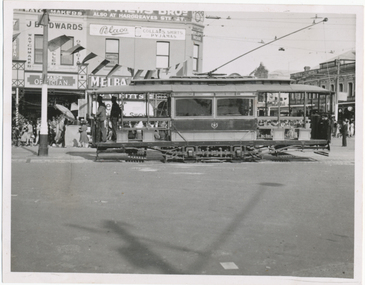
Photograph - Bendigo No. 1 - Easter Fair, Wal Jack, Easter Saturday 1941
Photograph of ESCo tram No. 1 entering Pall Mall from the Eaglehawk line, side view probably running into the depot. The tram has been modified with bracing and open saloon seats changed from cross bench to longitudinal and has been painted in SEC 1930s colours with an SEC monogram. The conductor is standing in the front saloon. Photo taken Easter Saturday 1941. See item 9100 for a similar photo. In the background are signs or buildings for J. B. Edwards Opticians and Pelaco collars, shirts and Pyjamas. i1 - scan of print in the album i2 - rear of image i3 - scan of negative at 3200dpi added 6/6/2020. Yields information about Bendigo 1 Easter 1941.Black and White print contained within the Wal Jack Bendigo and Geelong Album, see Reg Item 5003 for more details.On rear in ink "T195, Bendigo / No. 1 (Original type), Pall Mall, Easter Saturday 1941. Photo W. Jack.trams, tramways, bendigo, esco, secv, pall mall, tram 1 -
 Surrey Hills Historical Society Collection
Photograph, 'Brenston', 22 Albion Street, Surrey Hills under construction, c 1907, c 1907
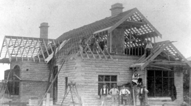
BDM records: Birth: Harrison Walter Spare Buchanan b 1900, Surrey Hills, son of Amelia Jane Spare and William Tennant Buchanan; died 1977 at Box Hill. Electoral roll records: 1924: Harrison Walter Spare Buchanan (clerk), Amelia Jane Buchanan (HD) and William Tennant Buchanan are listed at 22 Albion Street, known as ‘Brenston’. This and No 24 ‘Thulecroft’ were built in 1907/08 by brothers-in-law Harrison Rotherham & William Buchanan. They used a process new to Melbourne at the time – making concrete bricks for which they used sand from Middlesex Road. Harrison Buchanan, son of William, is the small boy in the photo. Black and white photo of a brick house under construction. The walls are complete and also the roof trusses and chimneys but there is no tiling. A group of 6 men and a boy pose in front of the house, on scaffolding and on the roof.SH732 in pencil on the rear.brenston, thulecroft, house names, (mr) harrison rotherham, (mr) william tennant buchanan, (mr) harrison walter spare buchannan, (mr) amelia jane spare, kathleen martha mcfarland, kathleen martha harrison -
 Vision Australia
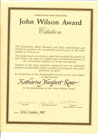
Award - Text, John Wilson Award citation - Katharine Margaret Rose, 1987
"The Committee, Blind Members and Staff acknowledge and record for posterity the outstanding service given to the blind people of Victoria by (blank) This exceptional contribution, which has enriched the quality of their living, was made in a selfless and warmhearted manner in the Association tradition of caring and sharing. Inherent in the many attributes displayed were the admirable qualities of leadership, loyalty, consistency of purpose, and a great generosity of spirit. In recognition of this distinguished service we now pay tribute to and honour Katharine Margaret Rose in the presentation of the John Wilson Award." Signed by Diana J. Jones (President), John Cook (staff representative), B. J. Sittlington (Chairman, Blind Members Council) on 16th October 1967.1 cream A3 page with tan border around edgeassociation for the blind, katharine (kitty) rose -
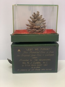 Mentone Grammar School
Archive, Memorial Cone from the original Lone Pine, Gallipoli, 1916
Memorial cone from the original 'Lone Pine' at Gallipoli, presented to Headmaster Neville Clarke by B Company, Mentone Grammar Cadet Unit, 15th August 1995 in memory of those who served. The Battle of Lone Pine was fought between Australian and New Zealand Army Corps (ANZAC) and Ottoman Empire forces during the Gallipoli Campaign of the First World War, between 6 and 10 August 1915. The battle was part of a diversionary attack to draw Ottoman attention away from the main assaults being conducted by British, Indian and New Zealand troops around Sari Bair, Chunuk Bair and Hill 971, which became known as the August Offensive. -
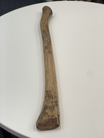 Mentone Grammar SchoolThe “Axe Handle” awards originated in 1988, when WO2 Zachary Reark (CSM B Coy and son of famed Old Mentonian, Jim Reark) found an old axe handle in the bush at the end of the 1988 annual Cadet camp. This he proudly marched out of camp with, under arm, in the manner of one bearing a pace stick. This idea seemed to catch on with the then CO, LTCOL Tony Drinan who decided that each CSM would be issued with one of these as a “perpetual trophy” marking his promotion to the rank of WO2 and appointment as a CSM. The name of the recipient was duly engraved on a plate affixed to the handle. The Archive Centre holds about 12 such axes as well as this original.
 -
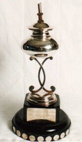 Royal Brighton Yacht Club
Cup, Almeida Cup
Almeida Cup Donor: Unknown Deed of Gift: No The trophy was presented in memory of William C. Almeida who was killed during a bank robbery. A memorial was erected in the park in Hampton opposite Linacre Road and Hampton Street. An inscription reads ‘Erected in memory of William C. Almeida of the Commercial Bank Hampton who gave his life in defence of his Trust 23.4.24. Aged 33 years.’ The trophy was originally used for B Division, now used for Combined Division on AMS handicap and raced on the same day as the Gullett Cup for PHD handicap and the Worcester Cup for IRC handicap. First Winner: Rita, C. W. Campbell 1925/26 almeida, cup, ams, combined division -
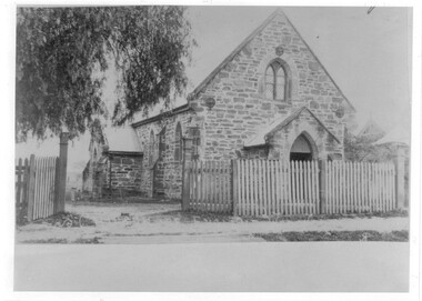 Wodonga & District Historical Society Inc
Photograph - St Luke's Church, Wodonga
St Luke’s Anglican Church officially opened on 15 March 1863 and originally operated as a branch of the Albury church. The first minister to conduct a service there was Rev. Robert Potter, followed by Rev. B. Brownrigg , Rev. J. H. May, Rev. D. E. Jones and Rev. J. K. Tucker. The first resident minister at Wodonga was Rev. J. H. White who came in 1879. The Church was constructed from locally hewn stone. After serving the congregation for more than a century, the Church was closed by the Health Commission due to its deteriorated condition which was judged to be beyond repair. It was demolished by voluntary labour on the 10 – 11 August 1968. A collection of 4 black and white photos depicting St. Luke's Church Wodonga at different times in its development.st luke's church wodonga, churches wodonga, early churches wodonga