Showing 1556 items
matching storey
-
 Kew Historical Society Inc
Archive (Sub-series) - Subject File, 'Fairview', 34 Wrixon Street (Kew), 1979
Various partiesReference, Research, InformationSecondary Values (KHS Imposed Order)Subject file containing information about Fairview (built 1924 for F.F. Robinson, proprietor of Yarra Falls Mills). The house replaced an earlier single-storey brick house, also called Fairview. A comprehensive report prepared by Alan Willingham in 2006 found that there was no evidence that the architect Desbrowe-Annear incorporated parts of the original building in the new construction. The work by Willingham is a ‘Cultural and Architectural History and Assessment of the Cultural Heritage Significance’ of the building, prepared for Carey Grammar School. The Willingham report was donated by Sr Ruth Anderson.kew (vic) - history, fairview - 34 wrixon street - kew (vic), cluny house - 34 wrixon street - kew (vic), f.f. robinson, alan willingham, harold desbrowe-annearkew (vic) - history, fairview - 34 wrixon street - kew (vic), cluny house - 34 wrixon street - kew (vic), f.f. robinson, alan willingham, harold desbrowe-annear -
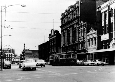 Melbourne Tram Museum
Photograph - Black & White Photograph/s, 1960's
Black and white photograph of trams W2 229, south bound in Swanston St, passing the now RMIT buildings. Has the Carlton United, Victoria Bitter buildings in the background. Tram has the destination of Malvern Darling Road, Route 4D. Photo taken early 1960's? given the cars around it. Photo taken from the south west side of the Latrobe St intersection. Has an ANZ bank and Storey hall in the background. Printed on Fujichrome paper. Not known who took the photograph or when it was printed.Stamped in black ink on back "TMSV Sales"trams, tramways, swanston st, rmit, latrobe st, darling rd, tram 229 -
 Bendigo Historical Society Inc.
Photograph - LA TROBE UNIVERSITY BENDIGO COLLECTION: SANDHURST HOSTEL
A white envelope with the words ' Sandhurst Hostel 1945 - 1959. ' The number 27 is at the top on the left-hand corner and the number is written on the back also. The envelope contains one large photo of Sandhurst Hostel, three proofs and two negatives of the hostel. This is a two storey building with verandas and ornate pediments. At the top of the building are two pediments each with the sign ' Heywood's Sandhurst House ' on them. There are six people standing on the balcony and below one person and a bicycle parked at the front of the building. St. Paul's Cathedral can be seen in the background.bendigo, buildings, hostel, la trobe university bendigo collection, collection, bendigo, education, bendigo teachers' college, hostel, hostels, sandhurst coffee palace, accommodation, place, buildings, negative, negatives, proof, proofs, coffee palace, tertiary education, teacher training, students -
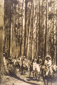 Upper Yarra Museum
Sepia Photograph, Mt Donna Buang, Warburton, 1912 (exact)
A large original print of the opening of the track to the summit of Mt Donna Buang. The party consists of horses with riders along with walkers.An original photo with the makers name at the bottom.The orgingal photograph of people on horses climbing the track to the summit of Mt Donna Buang for its opening. Unmounted photo by SearsInscription at bottom of photo "Mt Donna Buang, Warburton / Mr W.H.Edgar, Mrs Edgar, Mr Catani and Party / on the track to the Summit / 1912"original print, horses, mt donna buang, warburton, sears photo, mr w h edgar, mrs edgar, mr catani, track to mt donna buang, mr e a storey, damman, storey, catani, edgar, trees, track opening, mountain ash, eucalpytus regnans, 1912, hats -
!['Studley House', Nolan Avenue [Kew]](/media/collectors/550653872162f11fb04854aa/items/658d18490f23e8f1e738ec0d/item-media/658d18710f23e8f1e738ecc2/item-fit-380x285.jpg) Kew Historical Society Inc
Kew Historical Society IncPhotograph - 'Studley House', Nolan Avenue [Kew], c. 1965
The first section of Studley House, now part of the preparatory school for Xavier College conducted by the Society of Jesus in Kew, was built in about 1857 for Parliamentarian John Hodgson, an early settler in the district, as a two-storey residence in the Classical Revival style. The name Studley House was first recorded in the Kew ratebooks in 1862, after the house was purchased in 1860 by James McEvoy, squatter. Alterations and an extension, designed by William J Ellis were undertaken in 1875. The house was again altered in 1919 during the ownership of John Wren, former bookmaker, ALP lobbyist, influential Irish-Catholic and millionaire. After 1969 the house was used by the school. (Victorian Heritage Database, 2023)This work forms part of the collection assembled by the historian Dorothy Rogers (1905-1973), donated to the Kew Historical Society by her son in 2015. The manuscripts, photographs, maps, and documents were sourced by her from both family and local collections or produced as references for her print publications. Many were directly used by Rogers in writing ‘Lovely Old Homes of Kew’ (1961) and 'A History of Kew' (1973), or the numerous articles on local history that she produced for suburban newspapers. Most of the photographs in the collection include detailed annotations in her hand. The Rogers Collection provides a comprehensive insight into the working habits of a historian from the 1960s to the 1970s. Original monochrome photograph of Studley House in Nolan Avenue, Kew. The photo shows the entrance flanked by urns and a section of the Nolan Avenue facing rendered and painted colonnade.Annotation verso: "Studley House. Visited by Prince of Wales, Edward VIII. Another view. Front Entrance to Studley house. National Trust".dorothy rogers, studley house -- nolan avenue (kew) -
!['Studley House', Nolan Avenue [Kew]](/media/collectors/550653872162f11fb04854aa/items/658d1a9d0f23e8f1e738f8fa/item-media/658d1ac70f23e8f1e738f9c2/item-fit-380x285.jpg) Kew Historical Society Inc
Kew Historical Society IncPhotograph - 'Studley House', Nolan Avenue [Kew], c. 1965
The first section of Studley House, now part of the preparatory school for Xavier College conducted by the Society of Jesus in Kew, was built in about 1857 for Parliamentarian John Hodgson, an early settler in the district, as a two-storey residence in the Classical Revival style. The name Studley House was first recorded in the Kew ratebooks in 1862, after the house was purchased in 1860 by James McEvoy, squatter. Alterations and an extension, designed by William J Ellis were undertaken in 1875. The house was again altered in 1919 during the ownership of John Wren, former bookmaker, ALP lobbyist, influential Irish-Catholic and millionaire. After 1969 the house was used by the school. (Victorian Heritage Database, 2023)This work forms part of the collection assembled by the historian Dorothy Rogers (1905-1973), donated to the Kew Historical Society by her son in 2015. The manuscripts, photographs, maps, and documents were sourced by her from both family and local collections or produced as references for her print publications. Many were directly used by Rogers in writing ‘Lovely Old Homes of Kew’ (1961) and 'A History of Kew' (1973), or the numerous articles on local history that she produced for suburban newspapers. Most of the photographs in the collection include detailed annotations in her hand. The Rogers Collection provides a comprehensive insight into the working habits of a historian from the 1960s to the 1970s. Original monochrome photograph of the view from the first floor verandah of Studley House in Nolan Avenue, Kew. The photo shows the detail of the cast iron lace work used on this section of the verandah.Annotation verso: "Lovely lacework of the balcony Studley House"dorothy rogers, studley house -- nolan avenue (kew) -
!['Studley House', Nolan Avenue [Kew]](/media/collectors/550653872162f11fb04854aa/items/658f804b9239cf6fd436dc0a/item-media/658f80609239cf6fd436dcc6/item-fit-380x285.jpg) Kew Historical Society Inc
Kew Historical Society IncPhotograph - 'Studley House', Nolan Avenue [Kew], c. 1965
The first section of Studley House, now part of the preparatory school for Xavier College conducted by the Society of Jesus in Kew, was built in about 1857 for Parliamentarian John Hodgson, an early settler in the district, as a two-storey residence in the Classical Revival style. The name Studley House was first recorded in the Kew ratebooks in 1862, after the house was purchased in 1860 by James McEvoy, squatter. Alterations and an extension, designed by William J Ellis were undertaken in 1875. The house was again altered in 1919 during the ownership of John Wren, former bookmaker, ALP lobbyist, influential Irish-Catholic and millionaire. After 1969 the house was used by the school. (Victorian Heritage Database, 2023)This work forms part of the collection assembled by the historian Dorothy Rogers (1905-1973), donated to the Kew Historical Society by her son in 2015. The manuscripts, photographs, maps, and documents were sourced by her from both family and local collections or produced as references for her print publications. Many were directly used by Rogers in writing ‘Lovely Old Homes of Kew’ (1961) and 'A History of Kew' (1973), or the numerous articles on local history that she produced for suburban newspapers. Most of the photographs in the collection include detailed annotations in her hand. The Rogers Collection provides a comprehensive insight into the working habits of a historian from the 1960s to the 1970s. Original monochrome photograph of the first floor verandah of Studley House in Nolan Avenue, Kew. The photo shows the detail of the cast iron lace work used on this section of the verandah.dorothy rogers, studley house -- nolan avenue (kew) -
!['Studley House', Nolan Avenue [Kew]](/media/collectors/550653872162f11fb04854aa/items/658f8dc39239cf6fd43737f6/item-media/658f8dda9239cf6fd437386a/item-fit-380x285.jpg) Kew Historical Society Inc
Kew Historical Society IncPhotograph - 'Studley House', Nolan Avenue [Kew], c. 1965
The first section of Studley House, now part of the preparatory school for Xavier College conducted by the Society of Jesus in Kew, was built in about 1857 for Parliamentarian John Hodgson, an early settler in the district, as a two-storey residence in the Classical Revival style. The name Studley House was first recorded in the Kew ratebooks in 1862, after the house was purchased in 1860 by James McEvoy, squatter. Alterations and an extension, designed by William J Ellis were undertaken in 1875. The house was again altered in 1919 during the ownership of John Wren, former bookmaker, ALP lobbyist, influential Irish-Catholic and millionaire. After 1969 the house was used by the school. (Victorian Heritage Database, 2023)This work forms part of the collection assembled by the historian Dorothy Rogers (1905-1973), donated to the Kew Historical Society by her son in 2015. The manuscripts, photographs, maps, and documents were sourced by her from both family and local collections or produced as references for her print publications. Many were directly used by Rogers in writing ‘Lovely Old Homes of Kew’ (1961) and 'A History of Kew' (1973), or the numerous articles on local history that she produced for suburban newspapers. Most of the photographs in the collection include detailed annotations in her hand. The Rogers Collection provides a comprehensive insight into the working habits of a historian from the 1960s to the 1970s. Original monochrome photograph of the first floor verandah of Studley House in Nolan Avenue, Kew. The photo shows the detail of the cast iron lace work used on this section of the verandah.dorothy rogers, studley house -- nolan avenue (kew) -
!['Studley House', Nolan Avenue [Kew]](/media/collectors/550653872162f11fb04854aa/items/658f8e409239cf6fd4373b78/item-media/658f8e589239cf6fd4373bc1/item-fit-380x285.jpg) Kew Historical Society Inc
Kew Historical Society IncPhotograph - 'Studley House', Nolan Avenue [Kew], c. 1965
The first section of Studley House, now part of the preparatory school for Xavier College conducted by the Society of Jesus in Kew, was built in about 1857 for Parliamentarian John Hodgson, an early settler in the district, as a two-storey residence in the Classical Revival style. The name Studley House was first recorded in the Kew ratebooks in 1862, after the house was purchased in 1860 by James McEvoy, squatter. Alterations and an extension, designed by William J Ellis were undertaken in 1875. The house was again altered in 1919 during the ownership of John Wren, former bookmaker, ALP lobbyist, influential Irish-Catholic and millionaire. After 1969 the house was used by the school. (Victorian Heritage Database, 2023)This work forms part of the collection assembled by the historian Dorothy Rogers (1905-1973), donated to the Kew Historical Society by her son in 2015. The manuscripts, photographs, maps, and documents were sourced by her from both family and local collections or produced as references for her print publications. Many were directly used by Rogers in writing ‘Lovely Old Homes of Kew’ (1961) and 'A History of Kew' (1973), or the numerous articles on local history that she produced for suburban newspapers. Most of the photographs in the collection include detailed annotations in her hand. The Rogers Collection provides a comprehensive insight into the working habits of a historian from the 1960s to the 1970s. Original monochrome photograph of the interior of the first floor of Studley House in Nolan Avenue, Kew. The photo shows the detail of the landing and staircase. Note the later fretwork above the hall,Inscribed verso: "Studley House"dorothy rogers, studley house -- nolan avenue (kew) -
!['Studley House', Nolan Avenue [Kew]](/media/collectors/550653872162f11fb04854aa/items/658f93669239cf6fd4375d11/item-media/658f93b69239cf6fd4375f91/item-fit-380x285.jpg) Kew Historical Society Inc
Kew Historical Society IncPhotograph - 'Studley House', Nolan Avenue [Kew]
The first section of Studley House, now part of the preparatory school for Xavier College conducted by the Society of Jesus in Kew, was built in about 1857 for Parliamentarian John Hodgson, an early settler in the district, as a two-storey residence in the Classical Revival style. The name Studley House was first recorded in the Kew ratebooks in 1862, after the house was purchased in 1860 by James McEvoy, squatter. Alterations and an extension, designed by William J Ellis were undertaken in 1875. The house was again altered in 1919 during the ownership of John Wren, former bookmaker, ALP lobbyist, influential Irish-Catholic and millionaire. After 1969 the house was used by the school. (Victorian Heritage Database, 2023)This work forms part of the collection assembled by the historian Dorothy Rogers (1905-1973), donated to the Kew Historical Society by her son in 2015. The manuscripts, photographs, maps, and documents were sourced by her from both family and local collections or produced as references for her print publications. Many were directly used by Rogers in writing ‘Lovely Old Homes of Kew’ (1961) and 'A History of Kew' (1973), or the numerous articles on local history that she produced for suburban newspapers. Most of the photographs in the collection include detailed annotations in her hand. The Rogers Collection provides a comprehensive insight into the working habits of a historian from the 1960s to the 1970s. Original monochrome photograph of a bedroom on the first floor of Studley House in Nolan Avenue, Kew. The headlight windows were added during an early twentieth century renovation of the house.dorothy rogers, studley house -- nolan avenue (kew), xavier preparatory school -
![Studley House, Nolan Avenue [Kew]](/media/collectors/550653872162f11fb04854aa/items/658f95e19239cf6fd43769e5/item-media/658f95f59239cf6fd4376a47/item-fit-380x285.jpg) Kew Historical Society Inc
Kew Historical Society IncPhotograph - Studley House, Nolan Avenue [Kew]
The first section of Studley House, now part of the preparatory school for Xavier College conducted by the Society of Jesus in Kew, was built in about 1857 for Parliamentarian John Hodgson, an early settler in the district, as a two-storey residence in the Classical Revival style. The name Studley House was first recorded in the Kew ratebooks in 1862, after the house was purchased in 1860 by James McEvoy, squatter. Alterations and an extension, designed by William J Ellis were undertaken in 1875. The house was again altered in 1919 during the ownership of John Wren, former bookmaker, ALP lobbyist, influential Irish-Catholic and millionaire. After 1969 the house was used by the school. (Victorian Heritage Database, 2023)This work forms part of the collection assembled by the historian Dorothy Rogers (1905-1973), donated to the Kew Historical Society by her son in 2015. The manuscripts, photographs, maps, and documents were sourced by her from both family and local collections or produced as references for her print publications. Many were directly used by Rogers in writing ‘Lovely Old Homes of Kew’ (1961) and 'A History of Kew' (1973), or the numerous articles on local history that she produced for suburban newspapers. Most of the photographs in the collection include detailed annotations in her hand. The Rogers Collection provides a comprehensive insight into the working habits of a historian from the 1960s to the 1970s. Original monochrome photograph of architectural elements used in the decorative scheme on the exterior of Studley House in Nolan Avenue, Kew. dorothy rogers, studley house -- nolan avenue (kew), xavier preparatory school -
![Studley House, Nolan Avenue [Kew]](/media/collectors/550653872162f11fb04854aa/items/658f96939239cf6fd4376d56/item-media/658f96e99239cf6fd4376ed9/item-fit-380x285.jpg) Kew Historical Society Inc
Kew Historical Society IncPhotograph - Studley House, Nolan Avenue [Kew]
The first section of Studley House, now part of the preparatory school for Xavier College conducted by the Society of Jesus in Kew, was built in about 1857 for Parliamentarian John Hodgson, an early settler in the district, as a two-storey residence in the Classical Revival style. The name Studley House was first recorded in the Kew ratebooks in 1862, after the house was purchased in 1860 by James McEvoy, squatter. Alterations and an extension, designed by William J Ellis were undertaken in 1875. The house was again altered in 1919 during the ownership of John Wren, former bookmaker, ALP lobbyist, influential Irish-Catholic and millionaire. After 1969 the house was used by the school. (Victorian Heritage Database, 2023)This work forms part of the collection assembled by the historian Dorothy Rogers (1905-1973), donated to the Kew Historical Society by her son in 2015. The manuscripts, photographs, maps, and documents were sourced by her from both family and local collections or produced as references for her print publications. Many were directly used by Rogers in writing ‘Lovely Old Homes of Kew’ (1961) and 'A History of Kew' (1973), or the numerous articles on local history that she produced for suburban newspapers. Most of the photographs in the collection include detailed annotations in her hand. The Rogers Collection provides a comprehensive insight into the working habits of a historian from the 1960s to the 1970s. Original monochrome photograph of architectural elements used in the decorative scheme on the exterior of Studley House in Nolan Avenue, Kew. The POV is of the rendered and painted Doric columns supporting the first floor colonnade.dorothy rogers, studley house -- nolan avenue (kew), xavier preparatory school -
![Studley House, Nolan Avenue [Kew]](/media/collectors/550653872162f11fb04854aa/items/658f977b9239cf6fd4377127/item-media/658f978a9239cf6fd4377163/item-fit-380x285.jpg) Kew Historical Society Inc
Kew Historical Society IncPhotograph - Studley House, Nolan Avenue [Kew]
The first section of Studley House, now part of the preparatory school for Xavier College conducted by the Society of Jesus in Kew, was built in about 1857 for Parliamentarian John Hodgson, an early settler in the district, as a two-storey residence in the Classical Revival style. The name Studley House was first recorded in the Kew ratebooks in 1862, after the house was purchased in 1860 by James McEvoy, squatter. Alterations and an extension, designed by William J Ellis were undertaken in 1875. The house was again altered in 1919 during the ownership of John Wren, former bookmaker, ALP lobbyist, influential Irish-Catholic and millionaire. After 1969 the house was used by the school. (Victorian Heritage Database, 2023)This work forms part of the collection assembled by the historian Dorothy Rogers (1905-1973), donated to the Kew Historical Society by her son in 2015. The manuscripts, photographs, maps, and documents were sourced by her from both family and local collections or produced as references for her print publications. Many were directly used by Rogers in writing ‘Lovely Old Homes of Kew’ (1961) and 'A History of Kew' (1973), or the numerous articles on local history that she produced for suburban newspapers. Most of the photographs in the collection include detailed annotations in her hand. The Rogers Collection provides a comprehensive insight into the working habits of a historian from the 1960s to the 1970s. Original monochrome photograph of architectural elements used in the decorative scheme on the exterior of Studley House in Nolan Avenue, Kew. The POV is of the rendered and painted Ionic columns forming the first floor colonnade.dorothy rogers, studley house -- nolan avenue (kew), xavier preparatory school -
![Studley House, Nolan Avenue [Kew]](/media/collectors/550653872162f11fb04854aa/items/658f97ed9239cf6fd437726e/item-media/658f97f89239cf6fd43772b6/item-fit-380x285.jpg) Kew Historical Society Inc
Kew Historical Society IncPhotograph - Studley House, Nolan Avenue [Kew]
The first section of Studley House, now part of the preparatory school for Xavier College conducted by the Society of Jesus in Kew, was built in about 1857 for Parliamentarian John Hodgson, an early settler in the district, as a two-storey residence in the Classical Revival style. The name Studley House was first recorded in the Kew ratebooks in 1862, after the house was purchased in 1860 by James McEvoy, squatter. Alterations and an extension, designed by William J Ellis were undertaken in 1875. The house was again altered in 1919 during the ownership of John Wren, former bookmaker, ALP lobbyist, influential Irish-Catholic and millionaire. After 1969 the house was used by the school. (Victorian Heritage Database, 2023)This work forms part of the collection assembled by the historian Dorothy Rogers (1905-1973), donated to the Kew Historical Society by her son in 2015. The manuscripts, photographs, maps, and documents were sourced by her from both family and local collections or produced as references for her print publications. Many were directly used by Rogers in writing ‘Lovely Old Homes of Kew’ (1961) and 'A History of Kew' (1973), or the numerous articles on local history that she produced for suburban newspapers. Most of the photographs in the collection include detailed annotations in her hand. The Rogers Collection provides a comprehensive insight into the working habits of a historian from the 1960s to the 1970s. Original monochrome photograph of architectural elements used in the decorative scheme on the exterior of Studley House in Nolan Avenue, Kew. The POV is of the rendered and painted Doric columns forming the ground floor colonnade. Note the Victorian tessellated tiles used on the floor of the verandah.dorothy rogers, studley house -- nolan avenue (kew), xavier preparatory school -
 Expression Australia
Photograph, 'Mornington' - Jolimont Square, East Melbourne
'Mornington' is a two storey residence with basement, built in bi-chromatic brickwork and erected in 1869. Following the purchase by the Society of Jolimont Square this building was tenanted until early 1935, when Mr. and Mrs. Abraham moved in from Blackburn. Following Abraham's death in early 1940 the building was rented out again. In 1947 the then Welfare Superintendent and Missioner (Mr. Ernest A. Reynolds) and Mrs. Reynolds, established a Young Mens Hostel using "Mornington" and the adjoining house "Highgate". This Hostel operated until "Horace Bedggood Hostel" was opened in 1959. Mornington, later known as the 'Red Brick Building' or 'H.E.A.R. Service Building' was used in later years for the Society's H.E.A.R. Service.Jolimont Square is significant as part of an early sub-division in Melbourne. The building is an early example of well resolved bi-chromatic brickwork, and has unusual curved bays for the ground floor windows. 19cmHx24.5cmWmornington, jolimont square, highgate, bedggood, h.e.a.r. service, reynolds, abraham -
 Stawell Historical Society Inc
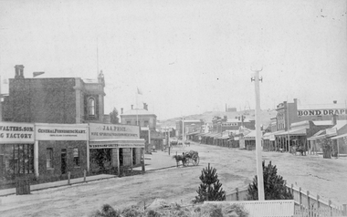
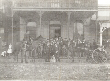
Photograph, Main Street Stawell looking East from the Present War Memorial site 1878
Main St. looking East towards Big Hill from Coffee Palace Verandah over Present War Memorial area. 1878 Businesses from left Walters and Son Factory, General Furnishing Mart, Stawell Town Hall, J. & A. Price Wine Spirits & Provision Merchants, Stawell Post Office. On right south side of Main Street, two-storey wooden Bull & Mouth Hotel, Whiteside Taylors, Carters Boot shop, Lecky Draper, C. Mulcahy Post Office Hotel, G.J. Hewlett Baker & Confectionery, Iron Monger, Victoria House Bond Draper, Town Hall Hotel, J. Richards Fancy Repository. Victorian Views. C. Herbert, Photo. Stawell 1878stawell business streetscape -
 Tarnagulla History Archive
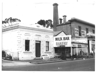
Photograph of milk bar and general store, Tarnagulla, Milk bar and general store, Tarnagulla, circa 1960s-70s
Murray Comrie Collection. This image depicts stores in the main street of Tarnagulla, including the two-storey bank building being used as a licensed general store. The building on the left was also a bank, originally constructed by the Union Bank in 1859, and Is probably the first brick and stone building at Tarnagulla. It was used by the bank until 1888 at which time the Union and Colonial banks amalgamated. After this, the building was used for a variety of purposes. The milk bar section was constructed in the 1920s in an area at the front of what had once been the Bank’s manager’s residence. The Two-story bank building On the right was constructed and used by the Colonial Bank of Australasia (from 1866 to 1888) and, following bank amalgamation, by the Union Bank (from 1888 until closure in 1942). The original site had been occupied by Joseph Foo's store, a large wooden building with attached theatre. While the bank was being built, the Colonial Bank operated from the former Company's Hotel (soon after to become the Borough of Tarnagulla Council Chambers, then the Mechanics’ Institute, and finally, prior to final demolition in 1980, Burstall Hall) The new double-storey building was used by the Colonial Bank from 1866 until 21st February, 1888. The premises were sold to the Union Bank for £2500. The Union Bank moved in and commenced operations on 6th June 1888, continuing until 1942. The building was later used as a general store until the 1990s. It is a now private residence. This is a reasonable copy of an older original. Copy probably made by Murray Comrie in the 1970s. Monochrome photograph depicting a section of Commercial Road, Tarnagulla near the intersection with Poverty Street, including two stores - one a bakery/milk-bar and the other a general store operating in the former Colonial/Union Bank building. Photograph taken from north of milk-bar. Two people walking away from photographer on footpath/curb between the two stores. The building on the left was the Union Bank premises, constructed in 1859 and Tarnagulla's oldest surviving brick building. The Union Bank absorbed the Colonial Bank in 1888, and the Union Bank moved operations next door into the much larger former Colonial Bank premises which had been constructed in 1865/66. After amalgamation, the old Union Bank premises was then used for a variety of purposes from visiting doctor's rooms to cafe, etc. The Union Bank continued to operate at Tarnagulla until closure in 1942, at which time business had fallen away and Tarnagulla Branch had already been downgraded to sub-branch status. tarnagulla, banks, banking, commerce, stores, shopping, shops, food, groceries, buildings, commercial road -
 Glen Eira Historical Society
Album - Album page, Kambrook Road, Circa 1972
This photograph is part of the Caulfield Historical Album 1972. This album was created in approximately 1972 as part of a project by the Caulfield Historical Society to assist in identifying buildings worthy of preservation. The album is related to a Survey the Caulfield Historical Society developed in collaboration with the National Trust of Australia (Victoria) and Caulfield City Council to identify historic buildings within the City of Caulfield that warranted the protection of a National Trust Classification. Principal photographer thought to be Trevor Hart, member of Caulfield Historical Society. Most photographs were taken between 1966-1972 with a small number of photographs being older and from unknown sources. All photographs are black and white except where stated, with 386 photographs over 198 pages. https://vhd.heritagecouncil.vic.gov.au/places/43737 - re 26 Kambrook Road and 345 Balaclava Road corner building: A prominently situated two-storeyed complex of late Victorian buildings consisting of "Wybar's Buildings" occupying the Balaclava Road/ Kambrook Road corner and the "Caulfield Bakery" facing Kambrook Road, separated by a driveway from a single storeyed shop. The main building has a comer splay and balustraded parapet with curved pediments, the words "Wybar's Buildings 1887" having been obliterated but "Caulfield Bakery 1887" with the characteristic wheatsheaf surviving in raised cement work. The walls are stuccoed and richly ornamented with bracketed cornices and keystones with masks extending to the Bakery. The main building is further distinguished by the Masonic symbol of the mason's dividers in the pediment whilst the upper level of the bakery is in overpainted brickwork. The single storeyed shop incorporates the bracketed cornice and consoles characteristic of the main buildings and is in other respects a utilitarian structure. https://vhd.heritagecouncil.vic.gov.au/places/35413 - re 16 Kambrook Road A small late Victorian Italianate villa distinguished by its parapeted window bays either side of a small verandah with encaustic tiled floor. The parapets are balustraded with console enrichment and glazed tiles, the stuccoed surfaces being unpainted. Ornamentation is in other respects undistinguished. https://www.gleneira.vic.gov.au/services/planning-and-building/heritage/heritage-management-plan - re 9-11 Kambrook Road ... they demonstrate most of the commonly employed aesthetic devices characteristic of the Italianate Style including patterned brickwork, patterned slate roofs, cast iron lace verandahs, ornamental stucco work and ashlar boards...https://vhd.heritagecouncil.vic.gov.au/places/43737 - 345 Balaclava and 26 Kambrook Roads HO91 in City of Glen Eira "Wybar's Buildings" at the corner of Balaclava Road and Kambrook Road are important as a prominent late Victorian commercial development incorporating a variety of activities including a bakery and possibly a coffee palace, the latter understood to be unique within the municipality, but characteristic of the period. It is a rare complex of its type in Caulfield and is important also as evocative evidence of the late Victorian Land Boom and the creation of a small now defunct commercial centre at this location by the George Wybrow. https://vhd.heritagecouncil.vic.gov.au/places/35413 - 16 Kambrook Road HO121 in City of Glen Eira ''Hollywood'' at 16 Kambrook Road is of architectural interest for its pavilions which retain their unpainted parapets and ornamental tiles in the manner of other less imposing examples in the immediate locality possibly linked with the builder George Wybar and his son, who undertook substantial projects nearby. Its association with James Yorston, presumably is Yorston of Dickson and Yorston, important builders and estate developers at Caulfield during the Inter war period is of interest. https://www.gleneira.vic.gov.au/services/planning-and-building/heritage/heritage-management-plan - re 9-11 Kambrook Road HO152 Normanby Road/Kambrook Road, Caulfield North Statement of Significance: The Precinct is historically significant for its capacity to demonstrate standards of design and building construction in this part of the municipality during the late Land Boom years and especially just prior to the bank collapse of 1891. The housing stock is representative of the standards of amenity excepted by the middle classes of Melbourne society at the time, including artists, (horse) trainers, jockeys, managers, travellers, journalists and the like, also having a functional link with the activities of the Caulfield Racecourse which forms an important element in the history of the Municipality. The row of attached pairs at 5-11 Kambrook Road and 53-67 Kambrook Road is especially significant in this respect in that the narrow allotments are indicative of the owner/developer’s determination to maximise profits at the height of the Land Boom in 1891...Page 104 of Photograph Album with four photographs (landscape) of three different properties on Kambrook Road.Handwritten: Kambrook Road [top right] / WYBAR'S BUILDING 1887/ INC CAULFIELD BAKERY / [under top right photo] / 16 KAMBROOK ROAD / 1970 HIRST MRS J.N.[under bottom left photo] / 11-9 KAMBROOK ROAD / 1970 9-BUCKLAND MRS L.A / 11- ATKINS MRS N.E. [under bottom right photo] / 104 [bottom right]trevor hart, kambrook road, victorian, caulfield north, parapets, wybar's buildings 1887, caulfield bakery 1887, architectural features, painted bricks, balaclava road, victorian italianate style, houses, bay windows, verandahs, glazed tiles, shops, george wybar, builders, james yorston, dickson and yorston, j n hirst, l a buckland, n e atkins, patterned slate roofs, patterned bricks, cast iron work, attached houses -
 Glen Eira Historical Society
Album - Album page, Kambrook Road, Circa 1972
This page of photographs is part of the Caulfield Historical Album 1972. This album was created in approximately 1972 as part of a project by the Caulfield Historical Society to assist in identifying buildings worthy of preservation. The album is related to a Survey the Caulfield Historical Society developed in collaboration with the National Trust of Australia (Victoria) and Caulfield City Council to identify historic buildings within the City of Caulfield that warranted the protection of a National Trust Classification. Principal photographer thought to be Trevor Hart, member of Caulfield Historical Society. Most photographs were taken between 1966-1972 with a small number of photographs being older and from unknown sources. All photographs are black and white except where stated, with 386 photographs over 198 pages. First 2 images: milkbar and residence corner Kambrook and Balaclava Roads ie south west corner - building named Airdrie 3rd image: https://vhd.heritagecouncil.vic.gov.au/places/43737 - re 26 Kambrook Road and 345 Balaclava Road corner building ie south east corner: A prominently situated two-storeyed complex of late Victorian buildings consisting of "Wybar's Buildings" occupying the Balaclava Road/ Kambrook Road corner and the "Caulfield Bakery" facing Kambrook Road, separated by a driveway from a single storeyed shop. The main building has a comer splay and balustraded parapet with curved pediments, the words "Wybar's Buildings 1887" having been obliterated but "Caulfield Bakery 1887" with the characteristic wheatsheaf surviving in raised cement work. The walls are stuccoed and richly ornamented with bracketed cornices and keystones with masks extending to the Bakery. The main building is further distinguished by the Masonic symbol of the mason's dividers in the pediment whilst the upper level of the bakery is in overpainted brickwork. The single storeyed shop incorporates the bracketed cornice and consoles characteristic of the main buildings and is in other respects a utilitarian structure. 4th image: https://vhd.heritagecouncil.vic.gov.au/places/42415 (on 24/01/2021) - 196 Kambrook Road An imposing late Victorian poly-chrome brick asymmetrical villa with corner verandah and projecting west facing wing with faceted window bay to the facade. Body bricks are red and relieved by cream and black brick banding and by cream bricks to the bracketed eaves. The fretted barge with king post treatment and timber posted verandah are unique in the Municipality and unusual in the metropolitan area and demonstrate an understated appreciation of the emerging Queen Anne mode.345 Balaclava and 26 Kambrook Roads HO91 - City of Glen Eira https://vhd.heritagecouncil.vic.gov.au/places/43737 (on 24/01/2021) "Wybar's Buildings" at the corner of Balaclava Road and Kambrook Road are important as a prominent late Victorian commercial development incorporating a variety of activities including a bakery and possibly a coffee palace, the latter understood to be unique within the municipality, but characteristic of the period. It is a rare complex of its type in Caulfield and is important also as evocative evidence of the late Victorian Land Boom and the creation of a small now defunct commercial centre at this location by the George Wybrow. 196 Kambrook Road HO122 - City of Glen Eira https://vhd.heritagecouncil.vic.gov.au/places/42415 "Glencoe" is situated at no. 196 Kambrook Road, Caulfield North and was built for the boot manufacturer, Robert Bruce Mair, in 1888. It is of historic and aesthetic significance. It is historically significant (Criterion A) as the home of an inner suburban industrialist, notable a boot manufacturer, demonstrating the attraction of Caulfield as a residential location for the manufacturers of the metropolis during the late Victorian Boom period. It is aesthetically significant (Criterion E) as a very early example of a Queen Anne influenced late Victorian villa, comparing at the State level with ''Woodlands'' (1888), North Essendon, generally acknowledged to be one of Australia's earliest houses to fully exploit this emerging style. The ornamental timberwork is especially expressive of the new architectural fashion and compares with the house at 33 Clarence Street, Elsternwick (1888-89).Page 105 of Photograph Album with two photographs of a milk bar and attached residence, one older photograph of Wybar's Building and another photograph of a house on Kambrook Road (all are landscape).Handwritten: 196 KAMBROOK ROAD / 1970 - GAFFNEY MRS S.M. [under bottom right photo] / 100 [bottom left]trevor hart, kambrook road, victorian style, caulfield north, parapets, wybar's buildings 1887, caulfield bakery 1887, architectural features, painted bricks, balaclava road, george wybrow, shops, milk bars, airdrie, polychrome bricks, verandahs, queen anne architectural style, houses, glencoe, robert mair -
 Glen Eira Historical Society
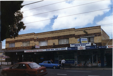
Photograph, Murrumbeena Road, 229-229A-231-231A-233, Murrumbeena, 2001
Originally labelled "Beauville Estate, Established 1936, Still Thriving 65 years on, 10th March 2001", the Beauville Estate Album contains colour photographs of houses in the Estate. They were taken around the time of the Beauville Estate’s 65th Heritage Celebration held on 10/03/2001 and donated to the Caulfield Historical Society shortly afterwards. Photographer unknown. 227 Murrumbeena Road (Bev Baxter Chemist) is not part of HO12.City of Glen Eira’s Heritage Management Plan Vol 2 p79 (this is p84 of the pdf version) – HO12 Beauville Estate and environs, Murrumbeena: The Beauville Historic Area is important at the State level as the first large housing estate undertaken by the AV Jennings Construction Co, later Jennings Group Limited, Victoria’s largest home builder. It is important also as a very early estate development incorporating a range of features other than houses and including made roads, shops and recreation facilities. In this respect it was the forerunner of the comprehensively planned housing estate of the post war era. The estate is distinguished by its aesthetic values, as is the earlier and comparable Hillcrest Estate, which are formed by a combination of restrained diversity in house styles, with the exception of no. 30 in the emerging International style, and by a landscaped garden environment. Colour photograph of a group of commercial properties with ground level shops and upper level two toned brown, unpainted brick residences. The photograph taken from across the road also includes parked cars, a person leaning on a car outside the fish and chip shop and a pedestrian crossing the road. Shops shown are from left to right: Cafe Fresca, 231 Hair Creations, Leovorno Pizza, Blue Sea Fish & Chips, Murrembeena (sic) Milk Bar and a portion of the one storey shop Bev Baxter Chemist at the right end. LEOVORNO PIZZA / BLUE SEA FISH & CHIP / Herald Sun / Sunday / MURREMBEENA MILK BAR / PK's / SANDWICH BAR / Bev Baxtermurrumbeena, architectural styles, 1930's, inter war style, a.v. jennings, av jennings, jennings, beauville estate, murrumbeena road, commercial establishments, shops, pharmacies, milk bars, fish shops, sir albert victor jennings, a v jennings construction co, beauville estate heritage area, glen eira city council, architectural features, jennings group limited, land subdivision, beauville historic area, brick shops, brick features, hairdressers, pizza shops, restaurants -
 Bendigo Historical Society Inc.
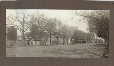
Photograph - HARGREAVES STREET, LOOKING SW
Black and white photograph on brown board mount. Tree lined street, buildings including Bendigo Town Hall, portion at the Market buildings. Weatherboard single storey shop / houses? One site appears to be being demolished, paling fence. Inscriptions: in image - hand printed BL corner 'Perc Pinder, Bendigo'. On board at front TR corner 'MP 130'. On back - hand written in ballpoint pen 'Hargreave St between Mundy and Chapel Sts, south side of street, Jewish synagogue on Hopetown St is in background', 'MP 130'.Perc Pinderplace, streetscape, hargreaves street -
 Bendigo Historical Society Inc.
Photograph - ORIENTAL BANK: EAGLEHAWK, 1860's ?
black and white photo mounted on same size board. Group of 30 men and boys outside double storey building with verandah with iron lace. At left man mounted on horse. At rigfht, horse and 4 wheeled vehicle. At centre 2 men, 1 each side of box with '1311' 4 pieces of smooth material piled on box ( smelted gold ? ) At far left, 2 girls, 1 bending down. On left hand window of building 'old' On RH window ' …. Mercial bank'? Above doorway at far left ' private entrance'organization, business, oriental bank, eaglehawk -
 Bendigo Historical Society Inc.
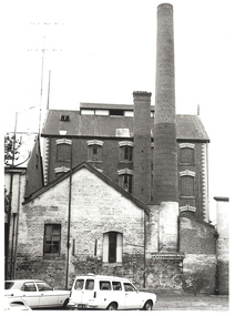
Photograph - FRIEDRICH AND BASSEMEIR VIENNA BAKERY: BENDIGO, 1960's ?
black and white photograph. Brick building, 3 or 4 storey, 2 chimneys, 1 square, 1 round. Lower brick building at front partially painted with 1 window and 1 double door. The door set into partially filled in brick arch. Main building has decorative brick work above windows and at corners of building. 2 vehicles in foreground, 1 sedan, 1 panel van. Corrugated iron roof, finial at each end above gable. Ball point pen on back 'Friedrich and Bassemeir Bakery, FSP/1204.organization, business, friedrich and bassemeir bakery -
 Bendigo Historical Society Inc.
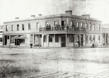
Photograph - METROPOLITAN HOTEL BENDIGO, 1861 ?
Black and white photo (copy). Metropolitan Hotel, Cnr. Bull Street and Hargreaves St., Bendigo. Also signed Metropolian Family Hotel. Two storey brick building with balcony around corner of building. Gentlemen in top hats and ladies standing on balcony. Unmade road in foreground. Boardwalk visible in front of photo. On LH side of building on ground floor : 'Bailes Tobacconist' sign on veranda over doorway (no roofing on verandah) Batchelder cart on RH side of photo. Photo taken in 1861. See Research field for further information.Batchelderbuildings, hotel, metropolitan hotel, metropolitan hotel. hargreaves street. bull street. batchelder, benjamin pierce. hotels. -
 Surrey Hills Historical Society Collection
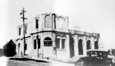
Photograph, Demolition of Tower House Day and Boarding School, Surrey Hills in 1932 (1)
This building dated back to the 1880s and had previously operated as Delany's Hotel and then the Royal Hotel. It was built near the site of the original Delany's Hotel, built in 1856. The Royal Hotel closed in 1921 after the area voted to be a 'dry area' in the local option poll. Tower House Day and Boarding School operated from 1921 until 1932. Norman Carter took many photos of Surrey Hills and Mont Albert from the 1920s; many were associated with events and activities of the Church of England.Black and white photo of a partially demolished building. The roof and part of the second storey are missing. What remains indicates that it has been a large building in the Victorian style. Along one side at ground level there are 4 arches, perhaps entry to a covered veranda, above which is a colonnade, and perhaps an open veranda on the upper level. There is a mixture of treatments to the surrounds of the windows. On the corner, within an arch which may have once been a doorway, is a sign reading: "TOWER HOUSE / DAY / & / BOARDING SCHOOL". There is a car with a retractable hood in the lower RH Corner of the photo.Rear top centre in blue biro "1932" (crossed out); top RH corner "498" in red biro; centre "Demolition of / Tower House Day & Boarding / cr Canterbury & Broughton Rds / previously Tower House Hotel / originally Royal Hotel / See partner photo."; bottom RH cnr "demol (in red biro) / 20-8-32". All in Jocelyn Hall's handwriting.tower house day and boarding school, schools, education, royal hotel, hotels, construction and demolition, dry area, licensing polls, temperance movement, delany's hotel, norman carter -
 Bendigo Historical Society Inc.
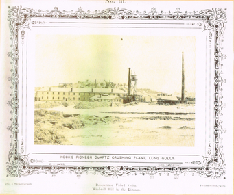
Photograph - LONG GULLY HISTORY GROUP COLLECTION: KOCK'S PIONEER QUARTZ CRUSHING PLANT LONG GULLY
The initial partnership in a quartz crushing plant between Henry Koch, Simon Albert and Charles Wallin was dissolved in 1860 with Koch becoming the sole owner. In 1866 the crushing plant consisted of a 50 hp engine and 48 stamping heads capable of crushing 600 tons of quartz per week. By 1902 there were 72 stamps and this was by far the largest crushing plant in the area, serving many quartz mines. Henry Koch (1800-1889) was a German sailor who signed off when his ship reached Melbourne in 1851. Having heard of the gold discovery he proceeded to Bendigo where he was initially employed in puddling in the Myers Flat area. He was soon employed and then made partner in a quartz crushing plant that he became sole owner of in 1860. He was also landlord at the British and American Hotel and the Silver Mines Hotel. HE also started the Perseverance United gold claim. He married Anna Maria Theresia Heinz in 1857. In 1872 he sold the crushing plant for 75,000 pounds and took his family back to Germany. He resumed his trade as a ship builder although he maintained many Bendigo mining interests.Yellow tone photo which has some green through it photo of Kock's Pioneer Quartz Crushing Plant, Long Gully. No 31 printed at the top. The photo has a decorative frame around it. It is a N. J. Caire Photo, Sandhurst and a Casey & Wenborn's Print. Forbes & Holmes, Agents. The photo has a long two storey building with chimneys and some smaller buildings and tall mine chimneys. Printed below is Perseverance United Claim and Windmill Hill in the distance. Paper is mounted on yellow card which is mounted on dark tan card and laminated.bendigo, history, long gully history group, the long gully history group - koch's pioneer quartz crushing plant - long gully, n j caire, casey & wenburn, forbes & holmes, perseverence united claim, windmill hill -
 Bacchus Marsh & District Historical Society
Photograph, Tom Oliver and family at Woodside, Parwan 1883
The family in this photograph is believed to be the Oliver family. Thomas Oliver, a farmer, advocated for a school at Parwan near Bacchus Marsh. This image depicts him and members of his family at his property, Woodside in 1883. The Woodside property was formerly owned by John Cook. The Olivers lived at Woodside during the 1870s and 1880s. Thomas Oliver retired around 1888 and moved to 'Elam's Cottage' in Bacchus Marsh. Three months after moving to Bacchus Marsh he died.Small sepia unframed photograph on card with gold border framing photograph. Housed in the album, 'Photographs of Bacchus Marsh and District in 1883 by Stevenson and McNicoll'. An image depicting a family group in front of a farm house. There are three men, two women and two small children standing or lying on a grassed area in front of the house, which has a post-and-rail fence. The farmhouse is a simple rectangular- shaped brick house with two chimneys and a tiled or slate roof. Behind the house can be seen a second building, also one-storeyed with a tiled or slate hip roof. On the front: Stevenson & McNicoll. Photo. 108 Elizabeth St. Melbourne. COPIES CAN BE OBTAINED AT ANY TIME. On the back: LIGHT & TRUTH inscribed on a banner surmounted by a representation of the rising sun. Copies of this Portrait can be had at any time by sending the Name and Post Office Money Order or Stamps for the amount of order to STEVENSON & McNICOLL LATE BENSON & STEVENSON, Photographers. 108 Elizabeth Street, MELBOURNE. stevenson and mcnicoll 1883 photographs of bacchus marsh and district, farms, farmers, oliver family parwan vic. -
 Charlton Golden Grains Museum Inc
Photograph, Victoria Hall, Armstrong St Charlton c. 1960, c.1960
Victoria Hall, Armstrong St Charlton was built for E. Miles in 1884. Sid Rosewall's house is on the right. This photo taken c. 1960.Colour photograph of a single storey, triple fronted red brick building. The front of the building is painted. There are double doors for the main entrance and three single doors - one to the left and two to the right of the main doors. There is a large, ornamental parapet wall on the front of the building with a flag pole. A wide verandah runs the length of the front of the building with a pitched section over the main entrance. The LH side of the building is unpainted and has four windows high on the wall. A red brick building is partially visible on the RH side of the photo. It has two chimneys and iron roof.e. miles, s. rosewall, victoria hall, armstrong street, charlton, halls -
Surrey Hills Historical Society Collection
Photograph - Surrey College staff and boarders, 1899, 1899
Surrey College was opened in early 1892 by Rev. Dr Frederick Darling who had been the first minister of the Presbyterian Church in Canterbury Road. He resigned this position to open the school which operated until 1908 with additional premises at 12 Vincent Street. The school had 40 boarders as well as day boys. Courses included algebra, euclid, history, typewriting, shorthand and drill. In the 1930s, Nethercourt Private Hospital took over the site. Later it became St Jude's Hospital. land in front of the building was subdivided off in the 1970s. The building is still extant as a private dwelling with York Street, Surrey Hills as the address. This is one of 3 photos donated by Susan Hobbs, whose grandfather Rev. George Edward Downton is thought to have been a student at the college. George E. Downton was born in Avoca in 1885. He was later a missionary in New Guinea and Secretary to the Australian Board of Missions in Adelaide. He died in 1926 or 1927. Sepia photo of 26 men and boys and one female against a background of a two-storey brick building. This is the rear of the Surrey College. There are 4 additional figures in the background and an additional house can be seen beyond the property boundary. Many of the boys wear or hold caps or boaters. The 2 men in the back row on the right are wearing academic gowns and mortar boards. The gentleman with the beard on the end is Rev. Frederick Darling, the Principal of the college. Sepia photo on cream mount board. Note that the photo is detached from the mount, so the photo is numbered SHP2025.15.1 and the mount as SHP2025.15.2.Front: "Surrey College - Surrey Hills / Principal: Rev. Fredk. A. DARLING, Melb. Univ./STAFF AND BOARDERS, 1899." Back: "York Street, Surrey Hills" in grey lead pencil; possibly Susan John's hand. Back, bottom LH corner: "L. Johnstone" Back, top RH corner: "5621" - this was the registration number used by box Hill historical society Middle back: Purple stamp - "Tennent/Photographer / 110 Johnstone Street / Collingwood" schools, 1899, surrey hills, surrey college, rev frederick a darling, george edward downton, susan hobbs, union road, nethercourt hospital, st jude's hospital, 219-223 union road, 1890-1899, york street -
Glenelg Shire Council Cultural Collection
Photograph - Photograph - South Portland Cemetery, n.d
Alexander Davidson arrived in Australia in 1838 as a poor Scotsman, a mason by trade. Alexander was to work hard and amass enough savings to allow him to invest in an established Squatting Run in 1848. As stated in his obituary "by patient industry and perseverance acquired considerable wealth as a squatter on the Satima station, near Casterton" on the Wando River in Victoria. He was at first a part-owner of the Satimer Run with his brother-in-law Duncan Robertson, but was able to buy out his brother-in-law's share in 1860. In 1864, with proceeds of his squatting income, he built a two storey stucco rendered bluestone house in Portland which he called "Wando Villa", which is today a Heritage Listed Building.Black and white photo. Alexander Davidson's grave, South Portland Cemetery. Granite monument with urn on top, surrounded by wrought iron fence. Inscription unreadableBack: 'ALEXANDER DAVIDSON'S GRAVE SOUTH PORTLAND CEMETERY, PORTLAND VICTORIA 1971' - hand printed, black biro Purple stamp 'ALEX PRIESTLEY BOX 155 PHONE 309 HEYWOOD VIC 3304squatter, squattocracy