Showing 31822 items
matching south
-
 Orbost & District Historical Society
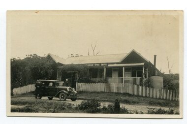
black and white photograph, 1920s -1930s
The Cabbage Tree Creek township was originally established to support the booming timber industry of the mid 20th century. Five timber mills worked full time supporting the families that were drawn to the area's wealth of natural resources. The settlement of Cabbage Tree Creek is located on the Princes Highway, 27 km east of Orbost in East Gippsland. The first white settler arrived in the valley in 1887 cutting a dray track from Marlo to the south-west. Several families cleared the alluvial flats, growing maize, peas and beans and raising pigs, cattle and sheep. Later the farmers milked cows, sending cream to Orbost. In the late 1890s, small quantities of alluvial gold were found in the creek. A school commenced classes in 1913, but enrolment was small and at times the school operated part time with several other small schools in the area. The school building served as a hall for the district. From the 1920s the Cabbage Tree Hotel catered to drivers on the improved Princes Highway. (info. from Victorian Places)This is a pictorial record of Cabbage Tree, East Gippsland in the late 20th century. It shows a building that no longer exists.A small black / white photograph of a single storey timber building. On a sign below the roof is "Cabbage Tree Hotel". The hotel is surrounded by a wooden picket fence. A man and woman are standing on either side of a motor car parked on the roadway in front of the building.on back - on label - Cabbage Tree Hotelcabbage-tree-hotel -
 Warrnambool and District Historical Society Inc.
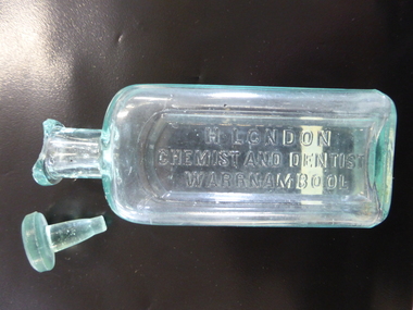
Bottle, H London Chemist, Early 1900s
This bottle was made by the Whitall Tatum Glass Company in New Jersey, U.S.A This company operated from 1806 to 1938. The bottle was used by Harry London in his Warrnambool pharmacy. Born in England, Harry London arrived in Victoria in 1883 and worked as a chemist in Ballarat and Euroa. In 1891 he went back to England where he studied dentistry. In 1891 he came to Warrnambool where he bought the pharmacy business of the late William Nettleton. He occupied the Nettleton building in Liebig Street (95 Liebig Street today) until 1896 when he erected new premises at the south west corner of Liebig and Koroit Streets. In 1896 London was the only Warrnambool chemist using a Pasteur filter to make up his prescriptions. In his dentistry business he used gas, chloroform and cocaine as anaesthetics. The making of dentures was his speciality. In 1904 London was the owner of the only set of Rontgen X Ray apparatus in Warrnambool. In 1905 his shop was the first in Warrnambool to establish electric lighting. This bottle is of importance as it is one of the few items we have associated with the prominent Warrnambool chemist, Harry London. It is comparatively rare so it is of some local significance. This is a glass bottle with a rectangular base with curved ledges, a circular neck and a circular moulded top. There is no stopper and the top is badly chipped. The name of the chemist is embossed on the front in an indent in the glass. ‘H. London, Chemist and Dentist, Warrnambool’ On Base: ‘W.T.Co, T, U.S.A.’ harry london, chemist, chemists in warrnambool, history of warrnambool -
 Warrnambool and District Historical Society Inc.
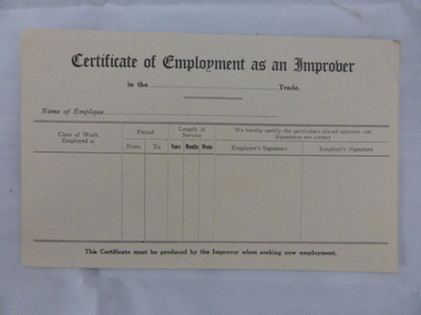
Document, Swintons certificate of Employment as an Improver, Mid 20th C
This certificate would have been used in the Warrnambool business of Swintons Pty Ltd. in the 20th century. It is a certificate that, when filled in, would have been given to anyone who had worked for some time as an unapprenticed tradesman’s assistant. William and Ann Swinton migrated to Australia in 1854 and for a decade William Swinton worked as a builder and carpenter in the Warrnambool district, erecting many buildings, including the Wangoom Presbyterian Church. In 1865 he opened a store in Timor Street, Warrnambool, selling groceries, china, glassware and hardware. By 1888 the business was known as William Swinton and Sons. Branch stores were opened in Wangoom, Cudgee, Nullawarre, South Warrnambool and West Warrnambool. After William Swinton’s death his son Robert became the first managing director of Swintons Pty Ltd. In 1934 the business split, with George Swinton and Sons selling clothing, furnishings and glassware and Swintons Pty Ltd selling hardware, seeds and produce. Today the Swinton family still operates a furniture and bedding store in Timor Street. This certificate is of minor interest as an example of a form used by businesses such as Swintons Pty Ltd to give to employees leaving the business. The current Swinton business in Timor Street, Warrnambool is the oldest family business in Warrnambool and, with the name Swinton associated with Timor Street businesses for 152 years, it is amongst the oldest family businesses in Australia.This is a sheet of buff-coloured paper with printed black lines and printed headings. The sheet is unused and slightly bent. ‘Certificate of Employment as an Improver’ swinton, history of warrnambool, warrnambool -
 Kiewa Valley Historical Society
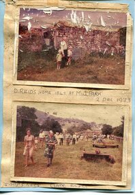
Photographs x 2- D Reids home at Mill Park 1973, 2/12/1973
David Reid (1820-1906) was a pastoralists and politician. He left school at 16 and after meeting the overlander John Gardiner he decided to look for land south of the Murray River. Equipped by his father with some 500 head of cattle, 2 bullock wagons and teams and 6 assigned servants, he reached the Ovens River on 8 September 1838. David settled at Currargarmonge, near Wangaratta. At the end of 1843 he took up land near Yackandandah. In 1847 he took up a section of the family run of which Woorajay (Wooragee) formed a part. He built the first water driven flour-mill in the district on his Yackandandah run in 1845; his woolclip of 1848 was one of the first to be handled by R. Goldsbrough and was claimed to come from sheep descended from stock imported in the 1820s from George III's flock. Going into politics, he held the Legislative Assembly seat of Murray from October 1859 to May 1862. David Reid was a highly regarded grazier and local politician who was significantly involved in settlement around the Yackandandah area. Photo demonstrates ongoing interest in the local history of the area and its early residents2 colour photographs mounted together on buff card 1. Man and 2 children (unidentified) standing outside the remains of the Reid home. 2 Dec, 1973 2. Group of unidentified people on a tour of the old homestead of D. Reid. 2 Dec, 19731. Handwritten in black ink under photo 'D. Reid's home 1845. At Mill Park. 2 Dec 1973 2. Handwritten in blue ink under photo 'Snapshots Clare Roper"clare roper -
 Kiewa Valley Historical Society
Photographs – Kiewa Cres Mt Beauty. Circa 1993. Set of 12 colour photographs
Established in 1946, during the construction of the Kiewa Hydro Electric Scheme, the township of Mt Beauty was developed by the State Electricity Commission of Victoria to provide additional accommodation for the thousands of workers during the construction of the country’s second largest hydro-electricity scheme. Although these towns were built as temporary accommodation for the workers and their families, many stayed after the scheme finished. Combined with the influx of European migrants, with their rich cultural backgrounds, all played a major part in shaping the future character of the Mount Beauty, the Kiewa Valley and Falls Creek. The Bright Council, now the Alpine Shire took over the control of the township in 1960. This relatively young town of Mount Beauty, along with the surrounding townships of Falls Creek, Bogong, Tawonga South and Tawonga, are all part of a prospering tourist area with excellent services, accommodation, food and a wide range of recreational activities available for all ages. According to Shire records, the population of Mt Beauty has grown from 1,500 in 1981 to 1,800 in 2016 with a projected increase to 2,000 in 2013The photographs taken around 1993 show a prosperous commercial centre catering for both locals and the needs of visitors. It provides a pictorial history of the changes which have occurred in the retail/commercial district of Mt Beauty over the years. It also demonstrates the attention paid by Alpine Shire towards providing accessible recreational green space around the town centre.Set of 12 colour photographs of Kiewa Cres Mt Beauty. Circa 1993 showing retail services and streetscape of the time. No markingskiewa cres mt beauty, mt beauty -
 Kiewa Valley Historical Society
Photographs – Lakeside Avenue, Mt Beauty. Circa 1993. Set of 7 colour photographs
Established in 1946, during the construction of the Kiewa Hydro Electric Scheme, the township of Mt Beauty was developed by the State Electricity Commission of Victoria to provide additional accommodation for the thousands of workers during the construction of the country’s second largest hydro-electricity scheme. Although these towns were built as temporary accommodation for the workers and their families, many stayed after the scheme finished. Combined with the influx of European migrants, with their rich cultural backgrounds, all played a major part in shaping the future character of the Mount Beauty, the Kiewa Valley and Falls Creek. The Bright Council, now the Alpine Shire took over the control of the township in 1960. This relatively young town of Mount Beauty, along with the surrounding townships of Falls Creek, Bogong, Tawonga South and Tawonga, are all part of a prospering tourist area with excellent services, accommodation, food and a wide range of recreational activities available for all ages. According to Shire records, the population of Mt Beauty has grown from 1,500 in 1981 to 1,800 in 2016 with a projected increase to 2,000 in 2013The photographs taken around 1993 show a prosperous commercial centre catering for both locals and the needs of visitors. It provides a pictorial history of the changes which have occurred in the retail/commercial district of Mt Beauty over the years. It also demonstrates the attention paid by Alpine Shire towards providing accessible recreational green space around the town centre.Set of 7 colour photographs of Lakeside Avenue, Mt Beauty. Circa 1993 showing retail services and streetscape of the time. No markingsmt beauty, lakeside ave mt beauty -
 Kiewa Valley Historical Society
Photographs – Tawonga Cres., Mt Beauty. Circa 1993. Set of 4 colour photographs
Established in 1946, during the construction of the Kiewa Hydro Electric Scheme, the township of Mt Beauty was developed by the State Electricity Commission of Victoria to provide additional accommodation for the thousands of workers during the construction of the country’s second largest hydro-electricity scheme. Although these towns were built as temporary accommodation for the workers and their families, many stayed after the scheme finished. Combined with the influx of European migrants, with their rich cultural backgrounds, all played a major part in shaping the future character of the Mount Beauty, the Kiewa Valley and Falls Creek. The Bright Council, now the Alpine Shire took over the control of the township in 1960. This relatively young town of Mount Beauty, along with the surrounding townships of Falls Creek, Bogong, Tawonga South and Tawonga, are all part of a prospering tourist area with excellent services, accommodation, food and a wide range of recreational activities available for all ages. According to Shire records, the population of Mt Beauty has grown from 1,500 in 1981 to 1,800 in 2016 with a projected increase to 2,000 in 2013The photographs taken around 1993 show a prosperous commercial centre catering for both locals and the needs of visitors. It provides a pictorial history of the changes which have occurred in the retail/commercial district of Mt Beauty over the years. It also demonstrates the attention paid by Alpine Shire towards providing accessible recreational green space around the town centre.Set of 4 colour photographs Tawonga Crescent, Mt Beauty. Circa 1993 showing retail services and streetscape of the time No markingstawonga cres mt beauty -
 Kiewa Valley Historical Society
Photographs – Holland Street North, Mt Beauty. Circa 1993. Set of 18 colour photographs
Established in 1946, during the construction of the Kiewa Hydro Electric Scheme, the township of Mt Beauty was developed by the State Electricity Commission of Victoria to provide additional accommodation for the thousands of workers during the construction of the country’s second largest hydro-electricity scheme. Although these towns were built as temporary accommodation for the workers and their families, many stayed after the scheme finished. Combined with the influx of European migrants, with their rich cultural backgrounds, all played a major part in shaping the future character of the Mount Beauty, the Kiewa Valley and Falls Creek. The Bright Council, now the Alpine Shire took over the control of the township in 1960. This relatively young town of Mount Beauty, along with the surrounding townships of Falls Creek, Bogong, Tawonga South and Tawonga, are all part of a prospering tourist area with excellent services, accommodation, food and a wide range of recreational activities available for all ages. According to Shire records, the population of Mt Beauty has grown from 1,500 in 1981 to 1,800 in 2016 with a projected increase to 2,000 in 2013The photographs taken around 1993 show a prosperous commercial centre catering for both locals and the needs of visitors. It provides a pictorial history of the changes which have occurred in the retail/commercial district of Mt Beauty over the years. It also demonstrates the attention paid by Alpine Shire towards providing accessible recreational green space around the town centre.Set of 18 colour photographs Holland Street North, Mt Beauty. Circa 1993 showing retail services and streetscape of the time. No markingsholland st mt beauty, mt beauty -
 Kiewa Valley Historical Society
Photographs – Kiewa Cres Mt Beauty. Circa 1993. Set of 12 colour photographs, circa 1993
Established in 1946, during the construction of the Kiewa Hydro Electric Scheme, the township of Mt Beauty was developed by the State Electricity Commission of Victoria to provide additional accommodation for the thousands of workers during the construction of the country’s second largest hydro-electricity scheme. Although these towns were built as temporary accommodation for the workers and their families, many stayed after the scheme finished. Combined with the influx of European migrants, with their rich cultural backgrounds, all played a major part in shaping the future character of the Mount Beauty, the Kiewa Valley and Falls Creek. The Bright Council, now the Alpine Shire took over the control of the township in 1960. This relatively young town of Mount Beauty, along with the surrounding townships of Falls Creek, Bogong, Tawonga South and Tawonga, are all part of a prospering tourist area with excellent services, accommodation, food and a wide range of recreational activities available for all ages. According to Shire records, the population of Mt Beauty has grown from 1,500 in 1981 to 1,800 in 2016 with a projected increase to 2,000 in 2013The photographs taken around 1993 show a prosperous commercial centre catering for both locals and the needs of visitors. It provides a pictorial history of the changes which have occurred in the retail/commercial district of Mt Beauty over the years. It also demonstrates the attention paid by Alpine Shire towards providing accessible recreational green space around the town centre.Set of 12 colour photographs Kiewa Cres Mt Beauty. Circa 1993 showing retail services and streetscape of the time. No markingskiewa crescent mt beauty; shopping centre; -
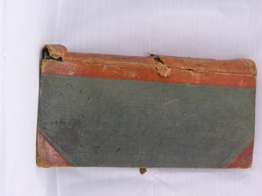 Warrnambool and District Historical Society Inc.
Book, Swintons Stock book 1869, 1860s
This ledger is a Warrnambool Swintons Store stock book and contains the sales of stock from September 1869 to an unknown date (perhaps to the end of 1870) and entries for 1871, 1872 and 1873, 1889, the 1890s and some dates early in the 20th century. William and Ann Swinton migrated to Australia in 1854 and for a decade William Swinton worked as a builder and carpenter in the Warrnambool area, erecting many buildings, including the Wangoom Presbyterian Church. In 1865 he opened a store in Timor Street, Warrnambool selling groceries, glassware and china. In 1888 the business was known as William Swinton and Sons. Branch shops were opened in Cudgee, Nullawarre, Wangoom, South Warrnambool and West Warrnambool. When William died his son Robert became the first managing director of Swintons Pty Ltd. In 1934 the business split in two with George Swinton and Sons selling furnishings, clothing and glassware and Swintons Pty Ltd selling seeds, hardware and produce. Today the Swinton family still operates a furniture and bedding store in Timor Street. This ledger is very important as an early memento of the Swinton Stores in Warrnambool. It gives details of sales in the 19th century and has material relating to the assets of the founder of the business, William Swinton at the time of his death. It is of great interest to researchers. The current family business in Timor Street Warrnambool is the oldest family business in Warrnambool and, with the Swinton name associated with businesses in Timor Street for 152 years, is among the oldest family businesses in Australia. This is a dark green hard cover ledger with light brown leather bindings on the spine and cover edges. There is gold lettering on the spine. The cover is stained and the leather is torn and partly detached in places. The insides of the cover have a blue and white mottled patterning. The pages are blue with printed red lines. The entries are handwritten in black ink. There are four loose pages and two pieces of a plant dried and preserved between two pages. ‘Day Book’ ‘Stock Book Warrnambool September 2nd 1869’ swinton family, warrnambool -
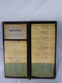 Warrnambool and District Historical Society Inc.
Ledger, Swintons, 1930s
This folder contains cards listing suppliers for the Warrnambool business, Swintons Pty Ltd. The cards date from the 1930s to the 1980s and contain information on the suppliers for seeds and farm requirements such as poultry pellets, calf food and stock salt. William and Ann Swinton migrated to Australia in 1854 and for a decade William Swinton worked as a builder and carpenter in the Warrnambool area, erecting many buildings, including the Wangoom Presbyterian Church. In 1865 he opened a shop in Timor Street, Warrnambool selling groceries, china, glass and hardware. By 1888 the business was known as William Swinton and Sons. Branch stores were opened in Cudgee, Nullawarre, Wangoom, South Warrnambool and West Warrnambool. After William died his son Robert became the first managing director of Swintons Pty Ltd. In 1934 the business split, with George Swinton and Sons selling furnishings, clothing and glassware and Swintons Pty Ltd selling seeds, hardware and produce. Today the Swinton family still operates a furniture and bedding store in Timor Street. This ledger is of interest as one from the Swinton business in Warrnambool. It gives us an idea of the items sold by Swintons Pty Ltd over a fifty-year period in the 20th century and will be very useful to researchers. The current Swinton business in Timor Street is the oldest family business in Warrnambool and, with the Swinton name associated with businesses in Timor Street, Warrnambool for 152 years, it is among the oldest family businesses in Australia. This is a black Kalamazoo folder made of thick board covered with material (leather?). The material is worn at the edges. The folder has a metal insert affixed with metal studs. The insert has thin metal wires strung across the inside. To these are affixed at the top with metal clips heavy-duty paper cards. There are two green cards with printed black material, one white card with printed blue material and the rest of the cards are yellow. The yellow cards are placed one under the other in a fan design. The yellow cards have printed red lines and printed titles and contain handwritten material, mostly in black ink. The cards, especially the green ones, are stained. ‘Kalamazoo-Acme Visible Card Books’swinton family warrnambool, history of warrnambool -
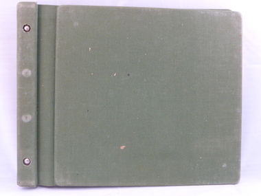 Warrnambool and District Historical Society Inc.
Ledger, Swintons Ledger, 1960s
This ledger was used in the Warrnambool business of Swintons Pty Ltd. It contains the records of financial statements for the years 1969 to 1978 – rates and taxes accounts, trial balances and accounts for light and power, wages etc. William and Ann Swinton migrated to Australia in 1854 and for a decade William Swinton worked as a builder and carpenter in the Warrnambool area, erecting many buildings including the Wangoom Presbyterian Church. In 1865 he opened a store in Timor Street Warrnambool, selling groceries, china and glass ware and hardware. By 1888 the business was known as William Swinton and Sons. Branch stores were opened in Cudgee, Nullawarre, Wangoom, South Warrnambool and West Warrnambool. After William Swinton died his son Robert became the first managing director of Swintons Pty Ltd. In 1934 the business split with George Swinton and Sons selling furnishings, clothing and glassware and Swintons Pty Ltd selling seeds, produce and hardware. Today the Swinton family still operates a furniture and bedding store in Timor Street. This ledger is of considerable interest as it contains much important information on the financial operations of Swintons Pty Ltd in the 1960s and 70s. This information will be very useful to researchers. The current Swinton business in Timor Street is the oldest family business in Warrnambool and, with the name Swinton associated with Timor Street businesses for 152 years, it is among the oldest family businesses in Australia. This is a hard cover book with a green cover and a green mottled patterning inside the cover. The pages are held in the cover by two metal studs. There are white and yellow pages which have A to Z tabs on the side. The pages have printed blue lines. The entries are handwritten in blue ink with some pencil entries.swinton family, warrnambool, history of warrnambool -
 Warrnambool and District Historical Society Inc.
Original Document, Map: Agricultural area of Ballangeich 1865, 1865
George Eddington arrived in Australia in 1839 and named and established property in 1841 calling the property Ballangeich after a Pass near his home town of Stirling in Scotland. It is situated 151 miles west of Melbourne and to the south of Mortlake and was originally part of the Mortlake shire, which was proclaimed 26th Jan 1864. Nearest streams are the Hopkins Riverand Lyall and Drysdale creek running through good agricultural land. This map relates to the breaking up of large runs which the Victorian government enabled through selection acts of the 1860's. The previously larger runs which were mainly cattle and sheep based were now more open to closer settlement and a greater variety in farming.The lots range in size from approximately 50 acres to around 600 acres.Some areas are set aside for reserves. By 1886 the population of Ballangeich had grown to around 600 with an hotel, three state schools and a church.Tri weekly coaches ran to Colac, Warrnambool and Camperdown providing access to supplies mail and communication. This map is typical of many which were produced in the 1860's in Victoria during a significant period of Victoria's and Warrnambool district history.Rectangular light card paper with black text showing allotments of land The area is coloured in green with scale at bottom right cornerAt the top: Plan of the Agricultural area of Ballangeich 1865 At the bottom left: Prepared by the Board of Lands & Works in accordance with the Amending Land Act 1865 Lands & Survey Office Melbourne 13th April 1865. With signaturehistory of warrnambool, ballangeich, land surveys victoria 1865, lands act 1865 victoria, ballangeich map 1865 -
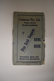 Warrnambool and District Historical Society Inc.
Leaflet, Kaye & Son, Printers, Swintons, Mid 20th century
This leaflet was a promotion tool of the Warrnambool business, Swintons Pty Ltd. It was used to insert stamps given by the firm when goods were purchased. When the pages were filled with 200 stamps the owner was given two shillings and sixpence in cash. It was a reward to the regular customer. William and Ann Swinton migrated to Australia in 1854 and for a decade William Swinton worked as a builder and carpenter in the Warrnambool area. In 1865 he opened a store in Timor Street, Warrnambool selling groceries, hardware, glassware and china. By 1888 the business was known as William Swinton and Sons. Branch stores were opened in Cudgee, Nullawarre, Wangoom, West Warrnambool and South Warrnambool. After William Swinton’s death, his son, Robert, became the first managing director of Swintons Pty Ltd. In 1934 the business split, with George Swinton and Sons selling furnishings, clothing and glassware and Swintons Pty Ltd selling groceries, seeds, produce and hardware. Today the Swinton family still operates a furniture and bedding store in Timor Street. This leaflet is of interest as an example of the advertising practices carried out by the firm of Swintons Pty Ltd, an important business in Warrnambool for many years. The current Swinton business in Timor Street, Warrnambool is the oldest family business in Warrnambool and, with the name Swinton associated with Timor Street businesses for 152years, it is amongst the oldest family businesses in Australia.This is a leaflet with a grey cover and four pages inside. The cover has dark blue printing and the pages have black printing and are ruled into 15 spaces. There are over 100 blue stamps stuck onto the ruled spaces. The cover is tattered at the edges and one stamp is loose.‘Swintons Pty Ltd Timor Street Warrnambool Provision, Seed and Hardware Merchants Blue Cash Coupons Bank Book’ swinton family businesses, warrnambool, history of warrnambool -
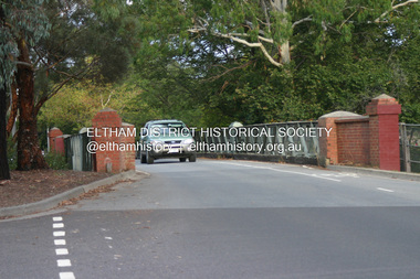 Eltham District Historical Society Inc
Photograph - Digital Photograph, Alan King, The Diamond Creek Bridge, 30 March 2008
Old Bridge on Main Hurstbridge road in Diamond Creek township crossing the Diamond Creek. The bridge opened in April 1898. Evelyn Observer, and South and East Bourke Record (Vic. : 1882 - 1902), Friday 22 April 1898, page 2 "Diamond Creek Bridge. The official opening of this bridge took place yesterday (Thursday) in the presence of a large gathering of people. The bridge-a substantial iron structure, costing .~r 2oo-was profusely decorated with "flags of all nations" for the occasion. In the absence of the Minister' of Public Works-who was unavoidably prevented from attending-the opening ceremony was neatly performed by President Lugton, of the Heidelberg Shire, in a few wellchosen words, after which an adjournment was made to the Literary Institute, where some sixty gentlemen were entertained at luncheon, followed by speeches, songs, and recitations. It was a red letter day for the Creek, and everything passed off with becoming eclat." Published: Nillumbik Now and Then / Marguerite Marshall 2008; photographs Alan King with Marguerite Marshall.; p7This collection of almost 130 photos about places and people within the Shire of Nillumbik, an urban and rural municipality in Melbourne's north, contributes to an understanding of the history of the Shire. Published in 2008 immediately prior to the Black Saturday bushfires of February 7, 2009, it documents sites that were impacted, and in some cases destroyed by the fires. It includes photographs taken especially for the publication, creating a unique time capsule representing the Shire in the early 21st century. It remains the most recent comprehenesive publication devoted to the Shire's history connecting local residents to the past. nillumbik now and then (marshall-king) collection, diamond creek, diamond creek bridge, main hurstbridge road -
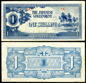 Lara RSL Sub Branch
Money, Japanese Goverment One Shilling, 1942
The Japanese government-issued Oceanian Pound was one of several issues of Japanese invasion money used during World War II. Consisting of only four denominations, the Oceanian Pound was the shortest set (i.e., total number of denominations) issued. Geographically, the region of Oceania comprises numerous islands across the vast South and Central Pacific which includes the islands of New Zealand.[1] Certain descriptions may or may not include Australia.[2] Oceania has also been defined by island groupings: Melanesia, Micronesia, and Polynesia.[1][3] However, from a numismatic perspective (i.e., the issuance of Japanese invasion money), Oceania consisted of the occupied territories of Guam, Gilbert and Ellice Islands, Caroline Islands, Marianas Islands, Solomon Islands, Palau, and the now defunct Territory of New Guinea.[4] [5] Although officially called "Oceania" the region was considered a financial and currency union under Japanese colonial dominion that included several political jurisdictions rather than a single polity.A blue coloured paper note with picture of fruit and an island beach on the front.On the front reads "Japanese Government One Shilling" and on the reverse the number 1. On the front in red are the letters "OC".money, paper, currency, japanese, wwii, japan, oceania, shilling, one, occupation, japanese government, blue -
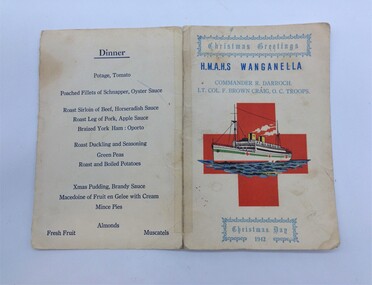 Montmorency–Eltham RSL Sub Branch
Functional object - Christmas Day Menu H.M.A.H.S. Wanganella
During World War II, Wanganella was converted to serve as an Australian Hospital Ship (AHS). Between 19 May 1941 and 1946, AHS Wanganella carried wounded and sick evacuees from the Middle East, New Guinea, Solomon Islands, Borneo and the South Pacific, travelling over 251,011 nautical miles (464,872 km) and transporting 13,385 wounded. A.H.S Wanganella 2/2nd Australian Hospital ship. Ref: "Hospital Ships" Rupert Goodman SLV LT 359.8364 0994 G62H Trip 8 Depart 12th Nov 1942 Melbourne Fremantle Aden 10th - 11th Dec 1942 Port Tewfik, Egypt 21st - 22nd Dec 1942 Colombo, Sri Lanka 01 Jan 1943 Fremantle Adelaide Melbourne Sydney Arrived 13th Jan 1943 Brisbane Wanganella left Colombo 22nd December 1942 for Fremantle, with patients who boarded at Port Tewfik in Egypt arriving on New Year's day 1943. The menu is printed on fawn cardboard. The menu has been torn along the spine and rearranged at some time to put on display. There is evidence of glue or tape damage at the back of each corner of the card. Some grease and finger marks are evident on the front and back of the card. The printing is very legible. The heading 'Christmas Greetings' is at the top of the front page and 'Christmas Day 1942' at the bottom of the page. Originally the menu was assembled as a leaflet with the menu on the inside of the second sheet. Since this time, the menu has been torn along the middle fold and the second page sheet taped to the first page. There is a red cross on the front page with a printed illustration of the Wanganella superimposed over the top. H.M.A.H.S. Wanganella and the dinner menu are printed in dark blue ink. The Christmas greetings and the names of the commander and officer in command of the troops are printed in light blue ink. h.m.a.h.s. wanganella, w.w.ii hospital ship -
 City of Moorabbin Historical Society (Operating the Box Cottage Museum)
Document,photocopy plan 'Two Acre Village 'c1852, c1960
In the 1852 Josiah Holloway, a developer, purchased 625 acres from the squatters Richard and John King and sectioned '2 acre allotments' south of Henry Dendy's Brighton Survey along the Arthur's Seat Road ( later Nepean Highway) for sale @ £10 It became known as The Two Acre Village as settlers took up the allotments and established market gardens, general stores, butchers, blacksmiths, post office and 2 hotels. Charles Whorral opened The Cheltenham Inn and it became so popular as a meeting place that the area was called Cheltenham. The early settlers, who were predominantly English and Scottish immigrants initially leased their allotments and, because the sandy soil was so fertile, they were soon able to purchase the land and increase their acreage. Cheltenham became a very important part of the large Moorabbin Shire1871 and City of Moorabbin 1934 In the 1994 Amalgamation of Councils, when the large City of Moorabbin was divided between the newly formed Glen Eira, Kingston and Bayside Councils, the Cheltenham area was assigned to the City of Kingston A photocopy of the Plan for the 2 Acre Village in Moorabbin Parish c1852. A3 laminatedmoorabbin, brighton, cheltenham, market gardeners, pioneers, early settlers, , king. john, holloway josiah, whorral charles, arthur’s seat road, nepean highway , cheltenham inn hotel, henry dendy special survey 1841 -
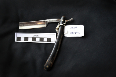 City of Moorabbin Historical Society (Operating the Box Cottage Museum)
Personal Effects, Cut-throat razor ‘Bengal’, early 20thC
Bengal’ THOMAS RADLEY CADMAN & SONS St. Mary's Road, Sheffield In business at least 1892-1919 Originally a trademark of Luke Cadman, Sheffield, England from ca. 1748-1906. From ca. 1906 - 1953, used by: Thomas Radley Cadman & Sons St. Mary's Road, Sheffield. In business at least between 1892 and 1965. The Cadman family originally came from Derbyshire and settled in the village of Eckington, to the south of Sheffield. Luke Cadman (1727-1788) moved to Sheffield in 1740 and became apprenticed into the cutlery trade. He became a freeman of the Cutlers' Company of Hallamshire in 1748 and was granted the trademark "BENGALL". (Another branch of the family was granted the trademark "SENEGALL"). Two of Cadman's sons followed him into the business. The Cadmans' business was located at various addresses in Sheffield over the years. In the early 1870s Thomas Radley Cadman (1833-1917) took over the firm. By 1933 the firm had diversified into safety razor and pocket knife manufacture. T.R.Cadman & Sons, Ltd. ceased trading in 1965. A man's cut-throat razor that folds to protect the blade inside the handle , 'Bengal'on blade 'BENGAL'cut-throat razors, straight razors, shaving equipment, steel blades, sheffield steel, england, thomas radley cadman & sons ltd., cutlers, steel manufacturers, ‘bengal’ trade mark, early settlers, market gardeners, moorabbin, bentleigh, cheltenham, -
 Eltham District Historical Society Inc
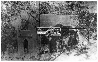
Negative - Photograph, Eltham - Old R.C. Church (building not there in 1923)
Eltham - Old R.C. Church (building not there in 1923). The original St Mary’s Roman Catholic Church (1865-1912) was built of clay brick with buttress walls and a slate roof on the corner of Fordhams Road and Maria Street (Main Road), Eltham South, opposite the present-day Wingrove Park. It was blessed on September 3, 1865. With the arrival of the railway in 1901 and the town centre moving closer to the station, the decision was made to relocate the site of the church to its present-day location on Henry Street at the corner of Main Road. A new timber weatherboard church, also called St Mary's was erected and blessed on October 13, 1912. The church and land cost £1,400 (Evelyn Observer). The original brick church It was demolished in the 1920s and the bricks and windows were recycled to build a dairy on the Brinkkotter farm at Research. The timber church was destroyed by fire in 1961 and a new modern architectural (1960s) style church was erected in its place and named Our Lady of Help Christians Church.This photo forms part of a collection of photographs gathered by the Shire of Eltham for their centenary project book,"Pioneers and Painters: 100 years of the Shire of Eltham" by Alan Marshall (1971). The collection of over 500 images is held in partnership between Eltham District Historical Society and Yarra Plenty Regional Library (Eltham Library) and is now formally known as the 'The Shire of Eltham Pioneers Photograph Collection.' It is significant in being the first community sourced collection representing the places and people of the Shire's first one hundred years.Digital image 4 x 5 inch B&W Negsepp, shire of eltham pioneers photograph collection, eltham, roman catholic church, catholic church, church, main road, st marys catholic church -
 Eltham District Historical Society Inc
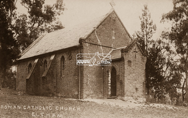
Negative - Photograph, St Mary's Roman Catholic Church, Eltham, c.1910
Note the extensive cracking of the mortar and bricks in the front facade near the portico entrance. The original St Mary’s Roman Catholic Church (1865-1912) was built of clay brick with buttress walls and a slate roof on the corner of Fordhams Road and Maria Street (Main Road), Eltham South, opposite the present-day Wingrove Park. It was blessed on September 3, 1865. With the arrival of the railway in 1901 and the town centre moving closer to the station, the decision was made to relocate the site of the church to its present-day location on Henry Street at the corner of Main Road. A new timber weatherboard church, also called St Mary's was erected and blessed on October 13, 1912. The church and land cost £1,400 (Evelyn Observer). The original brick church It was demolished in the 1920s and the bricks and windows were recycled to build a dairy on the Brinkkotter farm at Research. The timber church was destroyed by fire in 1961 and a new modern architectural (1960s) style church was erected in its place and named Our Lady of Help Christians Church.This photo forms part of a collection of photographs gathered by the Shire of Eltham for their centenary project book,"Pioneers and Painters: 100 years of the Shire of Eltham" by Alan Marshall (1971). The collection of over 500 images is held in partnership between Eltham District Historical Society and Yarra Plenty Regional Library (Eltham Library) and is now formally known as the 'The Shire of Eltham Pioneers Photograph Collection.' It is significant in being the first community sourced collection representing the places and people of the Shire's first one hundred years.Digital image 4 x 5 inch B&W Neg Sepia postcardsepp, shire of eltham pioneers photograph collection, eltham, roman catholic church, church, catholic church, main road, st marys catholic church -
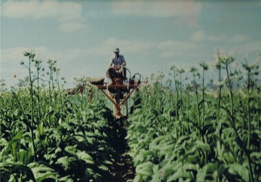
 Kiewa Valley Historical Society
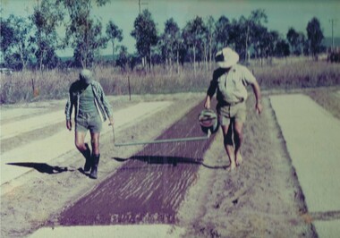
Photograph Tobacco planting, Planting Tobacco seeding, Circa mid to late 1900's
This promotional photograph by the Tobacco Growers Association was in response to a 1935 meeting of tobacco growers from Victoria, South Australia and Queensland which produced four major resolutions for the industry covering the remainder of the 1900s. These four resolutions were: (1) Adequate tariff protection (2) Control of pests and diseases (3) Orderly marketing (4) The formation of an advisory council of growers. History has produced the following results. (1) adequate tariff protection was never achieved,(2) control of disease through benzol vapour (CSIRO) breakthrough, was later identified as carcinogenic, (3) orderly marketing was achieved through (4) the establishment of the Tobacco Growers Association(1984). In October 2006, by way of Government buy back of tobacco leases from growers, resulted in the end of Tobacco farming in Australia (after 136 years of planting the first crop). It was also significant that the major tobacco companies such as Philip Morris and The British American Tobacco Australasia advised the industry that it would source its tobacco requirements overseas by 2009.The remnants of the Tobacco Industry can still be viewed throughout the Kiewa Valley and adjacent regions on the former tobacco farms which still have the tobacco drying sheds and now converted into hay sheds. The problems from the large quantities of carcinogenic infused soil of farmlands in the region, still remains a problem now and for future generations. This particular photograph shows the lack of understanding by farmers and the contracted labour, at that time, and is demonstrated by the bare footed farmer walking next to the seed canister. Some workers did use protective "gum" boots but the majority of farm owners were skeptical of city scientists and their carcinogenic concerns, and it was only after the younger generation of farmers , who had attended Agricultural colleges, encompassed the scientific approach to farm management and began working closely with agricultural scientists. The "she'll be right mate" attitude of the earlier farming/rural community has since mid 1970s, been slowly dissipating. Stricter controls of herbicides and pesticides used in agriculture are now in force. The death of the tobacco industry(2006) resulted in the expansion of the dairy , sheep, beef cattle, venison and lama wool producers in the Kiewa Valley and surrounding regions.Coloured photograph pasted onto a thick wood chip backing. Two galvanised eyelets at the top of the frame, 50mm from each end, with a twine cord stretch from each, for hanging purposes. See also KVHS 0054(B) to KVHS 0054(F)A sign, which has been removed from the picture at some previous point in time is "The Tobacco seed, being so fine, is suspended in water and sown onto the seed base using a watering can [as in the photo] or similar device - August - Sept."tobacco, farming, rural industry, licences, ollie mould, blue mould, benzol vapour -
 Kiewa Valley Historical Society
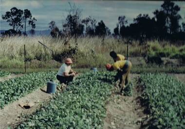
Photograph Tobacco seedlings, Pulling tobacco seedlings for Planting, Circa mid to late 1900s
This promotional photograph by the Tobacco Growers Association was in response to a 1935 meeting of tobacco growers from Victoria, South Australia and Queensland which produced four major resolutions for the industry covering the remainder of the 1900s. These four resolutions were: (1) Adequate tariff protection (2) Control of pests and diseases (3) Orderly marketing (4) The formation of an advisory council of growers. History has produced the following results. (1) adequate tariff protection was never achieved,(2) control of disease through benzol vapour (CSIRO) breakthrough, was later identified as carcinogenic, (3) orderly marketing was achieved through (4) the establishment of the Tobacco Growers Association(19840. In October 2006, by way of Government buy back of tobacco leases from growers, resulted in the end of Tobacco farming in Australia (after 136 years of planting the first crop). It was also significant that the major tobacco companies such as Philip Morris and The British American Tobacco Australasia advised the industry that it would source its tobacco requirements overseas by 2009.The death of the tobacco industry(2006) resulted in the expansion of the dairy , sheep, beef cattle, venison and lama wool producers in the Kiewa Valley and surrounding regions. The remnants of the Tobacco Industry can still be viewed throughout the Kiewa Valley and adjacent regions on the former tobacco farms which still have the tobacco drying sheds and now converted into hay sheds. The problems from the large quantities of carcinogenic infused soil of farmlands in the region, still remains a problem now and for future generations. This particular photograph shows the lack of understanding by farmers and the contracted labour, at that time, and is demonstrated by the lack of protection of hands when handling seedlings and attached soil. Hand and foot protection was rarely used, even when later warnings were issued of the carcinogenic toxicity of the soil. The majority of farm owners, up until Health authorities stepped in the later stages of 1900s, were skeptical of city scientists' "carcinogenic" health warnings and it was only after the younger generation of farmers, who had graduated from Agricultural colleges, encompassed the scientific approach to farm management. The "she'll be right mate" attitude of the farming/rural community has since the 1970s been slowly dissipating. Stricter controls of herbicides and pesticides used in agriculture are now in force.Coloured photograph pasted onto a thick wood chip backing. Two galvanised eyelets at the top of the frame, 50mm from each end, with a twine cord stretch from each, for hanging purposes. See also KVHS 0054A, KVHS0054C to KVHS 0054FA sign, which has been removed from the picture at some previous point in time is "Pulling seedlings for planting"tobacco, farming, rural industry, licences, ollie mould, blue mould, benzol vapour, photograph -
 Kiewa Valley Historical Society
Photograph Topping Tobacco, Tobacco being topped (removal of flower), Circa mid to late 1900's
This promotional photograph by the Tobacco Growers Association was in response to a 1935 meeting of tobacco growers from Victoria, South Australia and Queensland which produced four major resolutions for the industry covering the remainder of the 1900s. These four resolutions were: (1) Adequate tariff protection (2) Control of pests and diseases (3) Orderly marketing (4) The formation of an advisory council of growers. History has produced the following results. (1) adequate tariff protection was never achieved,(2) control of disease through benzol vapour (CSIRO) breakthrough, was later identified as carcinogenic, (3) orderly marketing was achieved through (4) the establishment of the Tobacco Growers Association(1984). In October 2006, by way of Government buy back of tobacco leases from growers, resulted in the end of Tobacco farming in Australia (after 136 years of planting the first crop). It was also significant that the major tobacco companies such as Philip Morris and The British American Tobacco Australasia advised the industry that it would source its tobacco requirements overseas by 2009.The remnants of the Tobacco Industry can still be viewed throughout the Kiewa Valley and adjacent regions on the former tobacco farms which still have the tobacco drying sheds and now converted into hay sheds. The problems from the large quantities of carcinogenic infused soil of farmlands in the region, still remains a problem now and for future generations. This particular photograph shows the lack of understanding by farmers and the contracted labour, at that time, and is demonstrated by the lack of protection of hands when handling seedlings and attached soil. Hand and foot protection was rarely used, even when later warnings were issued of the carcinogenic toxicity of the soil. The majority of farm owners, up until Health authorities stepped in the latter stages of 1900s, were skeptical of city scientists' "carcinogenic" health warnings and it was only after the younger generation of farmers, who had graduated from Agricultural colleges, encompassed the scientific approach to farm management. The "she'll be right mate" attitude of the farming/rural community has since the 1970s been slowly dissipating. Stricter controls of herbicides and pesticides used in agriculture are now in force. The death of the tobacco industry(2006) resulted in the expansion of the dairy , sheep, beef cattle, venison and lama wool producers in the Kiewa Valley and surrounding regions.Coloured photograph pasted onto a thick wood chip backing. Two galvanised eyelets at the top of the frame, 50mm from each end, with a twine cord stretch from each, for hanging purposes. See also KVHS 0054A ,KVHS 0054B and KVHC 0054D to KVHS 0054F A sign, which has been removed from the picture at some previous point in time is "The Tobacco crop being topped (flower removed)". tobacco, farming, rural industry, licences, ollie mould, blue mould, benzol vapour -
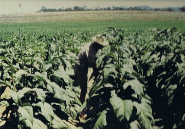 Kiewa Valley Historical Society
Photograph Tobacco plants, Tobacco fully grown prior to start picking, Circa mid to late 1900's
This promotional photograph by the Tobacco Growers Association was in response to a 1935 meeting of tobacco growers from Victoria, South Australia and Queensland which produced four major resolutions for the industry covering the remainder of the 1900s. These four resolutions were: (1) Adequate tariff protection (2) Control of pests and diseases (3) Orderly marketing (4) The formation of an advisory council of growers. History has produced the following results. (1) adequate tariff protection was never achieved,(2) control of disease through benzol vapour (CSIRO) breakthrough, was later identified as carcinogenic, (3) orderly marketing was achieved through (4) the establishment of the Tobacco Growers Association(1984). In October 2006, by way of Government buy back of tobacco leases from growers, resulted in the end of Tobacco farming in Australia (after 136 years of planting the first crop). It was also significant that the major tobacco companies such as Philip Morris and The British American Tobacco Australasia advised the industry that it would source its tobacco requirements overseas by 2009.The remnants of the Tobacco Industry can still be viewed throughout the Kiewa Valley and adjacent regions on the former tobacco farms which still have the tobacco drying sheds and now converted into hay sheds. The problems from the large quantities of carcinogenic infused soil of farmlands in the region, still remains a problem now and for future generations. This particular photograph shows the lack of understanding by farmers, at that time, and is demonstrated by the lack of protection of hands and no masks over their noses, when handling plants. Hand, nose and foot protection was rarely used, even when later warnings were issued of the carcinogenic toxicity of the soil. The majority of farm owners, up until Health authorities stepped in the latter stages of 1900s, were skeptical of city scientists' "carcinogenic" health warnings and it was only after the younger generation of farmers, who had graduated from Agricultural colleges, encompassed the scientific approach to farm management. The "she'll be right mate" attitude of the farming/rural community has since the 1970s been slowly dissipating. Stricter controls of herbicides and pesticides used in agriculture are now in force. The death of the tobacco industry(2006) resulted in the expansion of the dairy , sheep, beef cattle, venison and lama wool producers in the Kiewa Valley and surrounding regions.Coloured photograph pasted onto a thick wood chip backing. Two galvanised eyelets at the top of the frame, 50mm from each end, with a twine cord stretch from each, for hanging purposes. See also KVHS 0054A to KVHS 0054C and 0054E to KVHS 0054FA sign, which has been removed from the picture at some previous point in time is "The Tobacco fully grown prior to start picking"tobacco, farming, rural industry, licences, ollie mould, blue mould, benzol vapour -
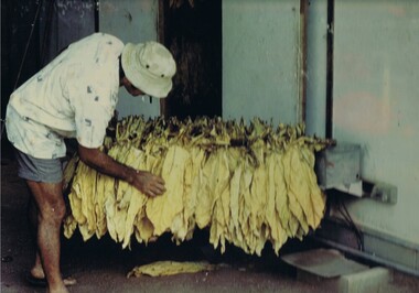 Kiewa Valley Historical Society
Photograph Tobacco drying leaves, Inspecting Drying tobacco leaves, 1950's to 1999
This promotional photograph by the Tobacco Growers Association was in response to a 1935 meeting of tobacco growers from Victoria, South Australia and Queensland which produced four major resolutions for the industry covering the remainder of the 1900s. These four resolutions were: (1) Adequate tariff protection (2) Control of pests and diseases (3) Orderly marketing (4) The formation of an advisory council of growers. History has produced the following results. (1) adequate tariff protection was never achieved,(2) control of disease through benzol vapour (CSIRO) breakthrough, was later identified as carcinogenic, (3) orderly marketing was achieved through (4) the establishment of the Tobacco Growers Association(19840. In October 2006, by way of Government buy back of tobacco leases from growers, resulted in the end of Tobacco farming in Australia (after 136 years of planting the first crop). It was also significant that the major tobacco companies such as Philip Morris and The British American Tobacco Australasia advised the industry that it would source its tobacco requirements overseas by 2009.The remnants of the Tobacco Industry can still be viewed throughout the Kiewa Valley and adjacent regions on the former tobacco farms which still have the tobacco drying sheds and now converted into hay sheds. The problems from the large quantities of carcinogenic infused soil of farmlands in the region, still remains a problem now and for future generations. This particular photograph shows the lack of understanding by farmers and the contracted labour, at that time, and is demonstrated by the lack of protection of hands when handling the tobacco leaves and nose from tobacco dust. Hand and foot protection was rarely used, even when later warnings were issued of the carcinogenic toxicity of the soil. The majority of farm owners, up until Health authorities stepped in the later stages of 1900s, were skeptical of city scientists' "carcinogenic" health warnings and it was only after the younger generation of farmers, who had graduated from Agricultural colleges, encompassed the scientific approach to farm management. The "she'll be right mate" attitude of the farming/rural community has since the 1970s been slowly dissipating. Stricter controls of herbicides and pesticides used in agriculture are now in force. The death of the tobacco industry(2006) resulted in the expansion of the dairy , sheep, beef cattle, venison and lama wool producers in the Kiewa Valley and surrounding regions.Coloured photograph pasted onto a thick wood chip backing. Two galvanised eyelets at the top of the frame, 50mm from each end, with a twine cord stretch from each, for hanging purposes. See also KVHS 0054A to KVHS 0054D and KVHS 0054Ftobacco, farming, rural industry, licences, ollie mould, blue mould, benzol vapour, photograph -
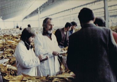 Kiewa Valley Historical Society
Photograph Tobacco selling, Tobacco sale floor, 1950 to 199
This promotional photograph by the Tobacco Growers Association was in response to a 1935 meeting of tobacco growers from Victoria, South Australia and Queensland which produced four major resolutions for the industry covering the remainder of the 1900s. These four resolutions were: (1) Adequate tariff protection (2) Control of pests and diseases (3) Orderly marketing (4) The formation of an advisory council of growers. History has produced the following results. (1) adequate tariff protection was never achieved,(2) control of disease through benzol vapour (CSIRO) breakthrough, was later identified as carcinogenic, (3) orderly marketing was achieved through (4) the establishment of the Tobacco Growers Association(19840. In October 2006, by way of Government buy back of tobacco leases from growers, resulted in the end of Tobacco farming in Australia (after 136 years of planting the first crop). It was also significant that the major tobacco companies such as Philip Morris and The British American Tobacco Australasia advised the industry that it would source its tobacco requirements overseas by 2009.This particular photograph shows prospective buyers (from the major processing firms of Philip Morris and British American Tobacco Australasia) inspecting the dried tobacco leaves at the Melbourne sales, before 2009, when they moved to overseas growers.The remnants of the Tobacco Industry can still be viewed throughout the Kiewa Valley and adjacent regions on the former tobacco farms, which still have the former tobacco drying sheds but now converted into hay sheds. The death of the tobacco industry(2006) resulted in the expansion of the dairy , sheep, beef cattle, venison and lama wool producers in the Kiewa Valley and surrounding regions. The problems from the large quantities of carcinogenic infused soil of farmlands in the region, still remains a problem now and for future generations. The tighter restrictions of where the final product can be smoked and the higher tax levied (no tariff protection) was the main contributor to this one time lucrative industry's demise.Coloured photograph pasted onto a thick wood chip backing. Two galvanised eyelets at the top of the frame, 50mm from each end, with a twine cord stretch from each, for hanging purposes. See also KVHS 0054A to KVHS 0054EA sign, which has been removed from the picture at some previous point in time is "Tobacco sale floor"tobacco, farming, rural industry, licences, ollie mould, blue mould, benzol vapour, photograph -
 Warrnambool and District Historical Society Inc.
Brass Plate, Dr Alfred Brauer, Circa 1930
This plaque is the name plate of one of Warrnambool's longest serving doctors. Alfred Ernest Brauer came to Warrnambool after graduating from the University of Melbourne in 1927. He initially took up the position as resident medical officer at the Warrnambool Base Hospital before entering private practice. he was appointed honorary medical officer at the hospital and was a life member of the Hospital board , serving as its president from 1952-54.he was a founding member of the South Western Victoria Ambulance service.as vice president, a position he held until his death in 1972.He had wide sporting and community interests including cricket, football, and horseracing. He was a founding member of the Warrnambool Lutheran church and was closely associated with Warrnambool High School and Warrnambool Technical School. he died in September 1972 and was survived by his wife and three daughters. His practice was situated in Koroit StWarrnambool, firstly at Ambleside where he also lived, then later on the other side of the street , in practice with a number of other doctors. A link to one of Warrnambool's longest serving doctors who contributed to the city in a wide range of roles. It therefore has strong historic and social significance.Rectangular brass plaque stamped and infilled with black. A screw hole in each of the four corners.Dr. Alfred Brauer physician & Surgeonwarrnambool, dr a e brauer, alfred brauer, warrnambool doctors, warrnambool doctors 1940-50's, ambleside warrnambool -
 Victoria Police Museum
Police Stations (Apsley)
Apsley is a small town in Victoria, Australia. It is on the Wimmera Highway, in the Shire of West Wimmera, 420 kilometres north-west of Melbourne, and 7 kilometres east of the South Australian border. Apsley Police Station opened on 29th November 1884 and was originally located in Wallace Street. It was staffed by one Foot Constable (motor cycle). The building was described, in 1930, as a four-roomed dwelling with an iron roof, set on a quarter of an acre of land. There was a bathroom, a WC, wash-house and a garage. An office adjoined the house and there was also a lockup. The station moved several times until the mid 1960s when a timber residence was moved onto land adjacent to the Post Office. The building is believed to have been transported from the Stawell area. Apsley is one of a handful of one-man police stations in Victoria and its current location, including residence, is at 19 Splatt Street. Apsley was in the Western District when it opened, then in "L" (Wimmera) District from January 1948 and "M" (Highlands/Wimmera) District from March 1990. 4 black & white photos, 1965 3 colour photos, 1987police stations; apsley police station -
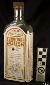 Flagstaff Hill Maritime Museum and Village
Container - Glass Bottle, W T Rawleigh, 1920s
W.T. Rawleigh's & Co. manufactured various household products in a factory in Collins Place, Melbourne, between 1930 and 1935. The W.T. Rawleigh Company was an American company started by William Rawleigh in 1889. The company expanded to both Canada and Australia with the Rawleigh company specialising in medicines, remedies, food additives, cleaning products and toiletries. Due to increased demand, Rawleigh’s required a larger factory and thus built the factory in Dawson Street Brunswick Victoria and by 1950 the factory had been extended to include 98,000 square feet of floor space. The Brunswick factory ceased production in the late 1970s and manufacturing was moved to New South Wales. During the peak of production, more than 200 people were employed in the Brunswick factory and several independent sale representatives sold their products door-to-door throughout the country. The ‘Rawleigh’s man’ was a regular door-to-door salesman of inter war and post-war suburban Melbourne. Rawleigh’s products are still in production today.A significant item as it gives a snapshot into domestic life and social norms of the pre and post war period in Melbourne and throughout Australia and New Zealand. The item demonstrates how selling house hold products door to door was pioneered in Australia by the Rawleigh’s company in the early 1900s and is still in existence today.Bottle, glass, narrow neck rectangular base with metal screw top.label of Rawleigh's Furniture Polishflagstaff hill, warrnambool, flagstaff hill maritime museum, shipwreck coast, flagstaff hill maritime village, great ocean road, bottle, rawleigh's furniture polish, furniture polish, rawleigh's, cleaning