Showing 2269 items
matching infrastructure
-
 Eltham District Historical Society Inc
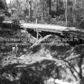
Album - Photograph, J.A. McDonald, Henley Road Bridge over Watsons Creek, Aug. 1962
Henley Road Bridge over Watsons Creek Yarra Glen Abutment August 1962Record of various Shire of Eltham infrastructure works undertaken during the period of 1952-1962 involving bridge and road reconstruction projects, sometimes with Eltham Shire Council Project Reference numbers quoted. It was during this period that a number of significant improvements were made to roads and new bridges constructed within the shire that remain in place as of present day (2022). In many situations, the photos provide a tangible visible record of infrastructure that existed throughout the early days of the Shire. The album was put together by or under the direction of the Shire Engineer, J.A. McDonald.H941 stamped on reverse (film processing #)infrastructure, shire of eltham, bridge construction, road construction, bushfires, 1962-08, bend of islands, henley road, henley road bridge, kangaroo ground, oxley bridge, watsons creek -
 Eltham District Historical Society Inc
Album - Photograph, J.A. McDonald, Henley Road Bridge over Watsons Creek, Sep. 1962
Henley Road Bridge over Watsons Creek Eltham Abutment September 1962Record of various Shire of Eltham infrastructure works undertaken during the period of 1952-1962 involving bridge and road reconstruction projects, sometimes with Eltham Shire Council Project Reference numbers quoted. It was during this period that a number of significant improvements were made to roads and new bridges constructed within the shire that remain in place as of present day (2022). In many situations, the photos provide a tangible visible record of infrastructure that existed throughout the early days of the Shire. The album was put together by or under the direction of the Shire Engineer, J.A. McDonald.H941 stamped on reverse (film processing #)infrastructure, shire of eltham, bridge construction, road construction, bushfires, bend of islands, henley road, henley road bridge, kangaroo ground, oxley bridge, watsons creek, 1962-09 -
 Eltham District Historical Society Inc
Album - Photograph, J.A. McDonald, Henley Road Bridge over Watsons Creek, Sep. 1962
Henley Road Bridge over Watsons Creek Yarra Glen Abutment September 1962Record of various Shire of Eltham infrastructure works undertaken during the period of 1952-1962 involving bridge and road reconstruction projects, sometimes with Eltham Shire Council Project Reference numbers quoted. It was during this period that a number of significant improvements were made to roads and new bridges constructed within the shire that remain in place as of present day (2022). In many situations, the photos provide a tangible visible record of infrastructure that existed throughout the early days of the Shire. The album was put together by or under the direction of the Shire Engineer, J.A. McDonald.H941 stamped on reverse (film processing #)infrastructure, shire of eltham, bridge construction, road construction, bushfires, bend of islands, henley road, henley road bridge, kangaroo ground, oxley bridge, watsons creek, 1962-09 -
 Eltham District Historical Society Inc
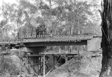
Negative - Photograph, J.A. McDonald, Healesville-Yarra Glen Road, c.1957
Bridge over Long GullyRecord of various Shire of Eltham infrastructure works undertaken during the period of 1952-1962 involving bridge and road reconstruction projects, sometimes with Eltham Shire Council Project Reference numbers quoted. It was during this period that a number of significant improvements were made to roads and new bridges constructed within the shire that remain in place as of present day (2022). In many situations, the photos provide a tangible visible record of infrastructure that existed throughout the early days of the Shire. The album was put together by or under the direction of the Shire Engineer, J.A. McDonald.infrastructure, shire of eltham, bridge construction, healesville-yarra glen road, 1957, long gully, healesville, long gully creek, old healesville road, jackson & dethridge, new zealand insurance co. ltd., public risk claim -
 Eltham District Historical Society Inc
Negative - Photograph, J.A. McDonald, Healesville-Yarra Glen Road, c.1957
Bridge over Long GullyRecord of various Shire of Eltham infrastructure works undertaken during the period of 1952-1962 involving bridge and road reconstruction projects, sometimes with Eltham Shire Council Project Reference numbers quoted. It was during this period that a number of significant improvements were made to roads and new bridges constructed within the shire that remain in place as of present day (2022). In many situations, the photos provide a tangible visible record of infrastructure that existed throughout the early days of the Shire. The album was put together by or under the direction of the Shire Engineer, J.A. McDonald.infrastructure, shire of eltham, bridge construction, healesville-yarra glen road, 1957, long gully, healesville, long gully creek, old healesville road, jackson & dethridge, new zealand insurance co. ltd., public risk claim -
 Wodonga & District Historical Society Inc
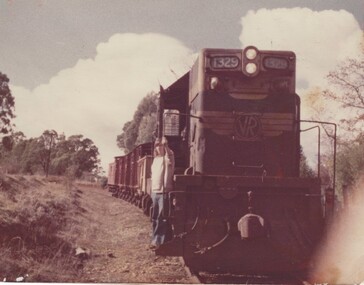
Photograph - Fred Rochow Railways Collection - Engine Instructor Geoff Williams
The Fred Rochow Railways Collection incorporates photos related to the operation of the Wodonga Railway Station including different types of trains and railways staff C. 1930 – 1990. It was donated to the Wodonga Historical Society by Fred Rochow, a railwayman who spent many years based in Wodonga. He joined the Victorian Railways on 17th June l947 and retired in 1988. For some time, he was a member of the Australian Federated Union of Locomotive Enginemen and served a term as a member of the Trades Hall Council. He had an extensive knowledge of the struggles that took place to achieve better conditions for railway workers. Fred worked for many years as a fireman and then worked his way up the ranks to driver, experiencing many changes from the days of steam locomotives through to diesel trains, locomotives and even the modern XPT train. He worked throughout Victoria at different stages of his career, with his final working years focused on the northeast of Victoria and the Albury to Melbourne line. After his retirement, Fred continued to share his love of steam miniature trains with the community.This collection has local and statewide significance as it captures images of trains, locomotives and personnel who operated the railway services in Wodonga and throughout Northeast Victoria. The railways played a critical role in opening up Victoria and connecting Australia for trade, business, social communication and transport.Engine Instructor Geoff Williams walking beside Locomotive 1329 to lift the hand brakes. The T class were a class of diesel locomotives built by Clyde Engineering, Granville, NSW for the Victorian Railways between 1955 and 1968. Locomotive T329 was part of the first order completed and entered service in June 1956. At that time, they became the most numerous diesel loco in Victoria. In 1984, the 13 first series T class locomotives were sent back to Clyde Engineering Plant at Somerton in Victoria for a complete rebuild after which they became the P class numbered P11 to P23. This included locomotive T329 which became Locomotive P12. The P Class have proven to be a reliable and dependable class, seeing service across the state in both passenger and freight duties. They often operated in push-pull mode, with a locomotive at each end of the train. The P class locomotives ceased being used for regular passenger operations in November 2012. Although locomotive P12 (T329) is primarily in storage it is still operational and can be hired for special events and as recently as 2017 was also used as an infrastructure maintenance train.At top of train between headlights "T329" In centre Victoria Railways logo "VR"fred rochow, victorian railways wodonga, locomotive 1329 -
 Wodonga & District Historical Society Inc
Photograph - Fred Rochow Railways Collection - Fireman Ian Sandford
The Fred Rochow Railways Collection incorporates photos related to the operation of the Wodonga Railway Station including different types of trains and railways staff C. 1930 – 1990. It was donated to the Wodonga Historical Society by Fred Rochow, a railwayman who spent many years based in Wodonga. He joined the Victorian Railways on 17th June l947 and retired in 1988. For some time, he was a member of the Australian Federated Union of Locomotive Enginemen and served a term as a member of the Trades Hall Council. He had an extensive knowledge of the struggles that took place to achieve better conditions for railway workers. Fred worked for many years as a fireman and then worked his way up the ranks to driver, experiencing many changes from the days of steam locomotives through to diesel trains, locomotives and even the modern XPT train. He worked throughout Victoria at different stages of his career, with his final working years focused on the northeast of Victoria and the Albury to Melbourne line. After his retirement, Fred continued to share his love of steam miniature trains with the community.This collection has local and statewide significance as it captures images of trains, locomotives and personnel who operated the railway services in Wodonga and throughout Northeast Victoria. The railways played a critical role in opening up Victoria and connecting Australia for trade, business, social communication and transport.Fireman Ian Sandford on steps of Locomotive T329. He is moving into position to apply the hand brakes. The T class were a class of diesel locomotives built by Clyde Engineering, Granville, NSW for the Victorian Railways between 1955 and 1968. Locomotive T329 was part of the first order completed and entered service in June 1956. At that time, they became the most numerous diesel loco in Victoria. In 1984, the 13 first series T class locomotives were sent back to Clyde Engineering Plant at Somerton in Victoria for a complete rebuild after which they became the P class numbered P11 to P23. This included locomotive T329 which became Locomotive P12. The P Class have proven to be a reliable and dependable class, seeing service across the state in both passenger and freight duties. They often operated in push-pull mode, with a locomotive at each end of the train. The P class locomotives ceased being used for regular passenger operations in November 2012. Although locomotive P12 (T329) is primarily in storage it is still operational and can be hired for special events and as recently as 2017 was also used as an infrastructure maintenance train.At top of train between headlights "T329" In centre Victoria Railways logo "VR"fred rochow, victorian railways wodonga, locomotive 1329 -
 Puffing Billy Railway
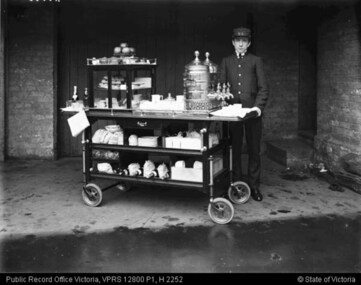
Equipment - Refreshments services Trolley, 1990s
The Refreshment Services Branch was established in 1920, and initially focused on providing station-based refreshment rooms and the dining car service. Its scope expanded to include diverse activities such as stall rental; sales of advertising space on railways infrastructure; laundry services; operation of a hair-dressing salon, a bakery, a butchery and a poultry farm; and the management of the chalet guesthouse at Mt Buffalo. The majority of staff worked in refreshment rooms and dining cars, both of which were a popular feature of the railway service. Previous to 1920 refreshment services had been provided by contractors, but after many complaints the Department decided to provide a standardised service across the system. It grew quickly: five years after it was established the Branch employed approximately 500 staff. Station refreshment facilities ranged from elaborate dining rooms to decorated push-carts. They were staffed predominately by women, who provided everything from a cup of tea to a three course meal. Most refreshment room services were closed in the 1970s. Reference from : Fielding, K. (2012) Victorian Railways - Refreshment Services Branch in Museums Victoria Collections http://collections.museumvictoria.com.au/articles/11470Historic - Replica of a a Victorian Railways Refreshment Services Serving Trolley used on Puffing Billy Railway Replica large wooden serving cart with fitted wooden cabinet featuring sliding glass doors and one glass shelf. Cart has chrome handles, two wooden shelves, a wooden drawer with chrome handle and a small chalkboard adhered to end. Cart has four small black rubber and metal wheels and a metal foot brake.puffing billy, serving trolley, replica, dining cart, refreshment services, victorian railways -
 National Vietnam Veterans Museum (NVVM)
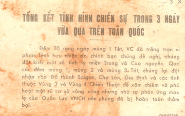
Pamphlet, A Summary of the War Situation in the country over the past days
From the 30th to the 1st day of Tet (Lunar New Year), the VC have shamelessly violated the truce that they themselves proposed. The have attacked a number of town in Central Vietnam and in the Highlands. On the nights of the 1st, 2nd, and 3rd of Tet, they have taken advantage to infiltrate into the capital, Saigon - and into Gia Dinh and Cho Lon. They have also attacked in the provinces of the 3rd and the 4th Tactical Zones to destroy infrastructure and public utilities. However, thanks to the rapid reaction of the Republic of Vietnam Armed Forces, they have been completely and humiliatingly defeated. (1968) On the reverse side reads: Herewith are the casualty rates of us and the enemy: Period: 30-01-68 - Our causalities 282 killed and wounded. Enemy 2,338 killed on the spot, 182 captured. Period 1-02-68 - Our soldiers: 203 killed and wounded. Enemy 2,617 killed, 198 captured. Period 2-02-68 to 12 midday: Our soldiers 211 killed and wounded. enemy 2,112 killed, 119 captured. Summary: Our casualties: 706, Enemy casualties 7,561. Enemy weapons captured: 144 crew-served weapon; 2,253 individual weapons.TONG KET TINH HINH CHIEN SU TRON 3 NGAY - VUA QUA TREN TOAN QUOC - A Summary of the war situation in the country over the past days: On one side there is information in Vietnamese and on the reverse side the information is in a table format.pamphlet, psycological warfare, propaganda, nva/vc, viet cong, 7th battalion, 1st battalion, the royal australian regiment, terry michael collie, 2790361, lunar new year, central vietnam, saigon, gia dinh, cho lon -
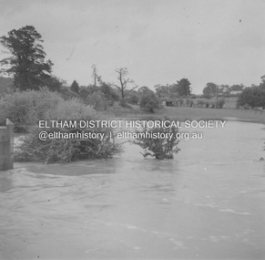 Eltham District Historical Society Inc
Album - Photograph, J.A. McDonald, Eltham-Greensborough Road, 18 Oct. 1956
Bridge Street Bridge Flooding on Hill’s property 18th October 1956 This view is looking west north west from the Bridge Street Bridge across the present day Eltham Skatepark. The shed visibile in the distance is directly opposite Brisbane Street where it used to run into Susan Street but now turns the corner. To the right of the shes is the site for present-dayHarris Plumbing which was formerly occupied by Sibbel Builders; to the left the site now occupied by Bunnings. At the skyline to the right of centreeline is a gap in the trees where the railway line runs. The Silver Street bridge over the railway is visible. Beware!.. our rivers are rising (1956, October 19). The Argus (Melbourne, Vic. : 1848 - 1957), p. 1. Retrieved August 24, 2022, from http://nla.gov.au/nla.news-article84392304Record of various Shire of Eltham infrastructure works undertaken during the period of 1952-1962 involving bridge and road reconstruction projects, sometimes with Eltham Shire Council Project Reference numbers quoted. It was during this period that a number of significant improvements were made to roads and new bridges constructed within the shire that remain in place as of present day (2022). In many situations, the photos provide a tangible visible record of infrastructure that existed throughout the early days of the Shire. The album was put together by or under the direction of the Shire Engineer, J.A. McDonald.infrastructure, road construction, shire of eltham, bridge construction, bridge street bridge, eltham, eltham-greensborough road, 1956-10-18, diamond creek (creek), floods, floodwater, hill property, silver street bridge -
 Eltham District Historical Society Inc
Negative - Photograph, J.A. McDonald, Eltham-Yarra Glen Road, Lower Plenty footbridge, Sep. 1955
Tony Carberry and J. Jolly The Eltham-Yarra Glen Road as designated originated at the Shire of Eltham boundary at the Plenty River. West of the river the road was known as the Heidelberg-Eltham Road. The section from the Plenty River is now known as Lower Plenty Road which becomes Main Road. The footbridge no longer exists but was originally sited to the south, adjacent to the old Lower Plenty Bridge, now part of the Plenty River Trail. Record of various Shire of Eltham infrastructure works undertaken during the period of 1952-1962 involving bridge and road reconstruction projects, sometimes with Eltham Shire Council Project Reference numbers quoted. It was during this period that a number of significant improvements were made to roads and new bridges constructed within the shire that remain in place as of present day (2022). In many situations, the photos provide a tangible visible record of infrastructure that existed throughout the early days of the Shire. The album was put together by or under the direction of the Shire Engineer, J.A. McDonald.1955-09, eltham-yarra glen road, lower plenty footbridge, j. jolly, lower plenty, lower plenty bridge, lower plenty road, main road, plenty river trail, tony carberry, bridge construction, infrastructure, shire of eltham -
 Eltham District Historical Society Inc
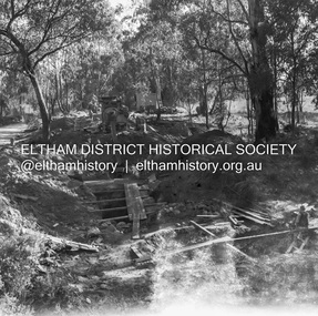
Negative - Photograph, J.A. McDonald, Henley Road at Watsons Creek, Mar. 1961
Old bridge over Watsons Creek 22 March 1961 Cr. Pelling and Contractor WolfRecord of various Shire of Eltham infrastructure works undertaken during the period of 1952-1962 involving bridge and road reconstruction projects, sometimes with Eltham Shire Council Project Reference numbers quoted. It was during this period that a number of significant improvements were made to roads and new bridges constructed within the shire that remain in place as of present day (2022). In many situations, the photos provide a tangible visible record of infrastructure that existed throughout the early days of the Shire. The album was put together by or under the direction of the Shire Engineer, J.A. McDonald.infrastructure, shire of eltham, 1961-03, bend of islands, cr. charis pelling, henley road, henley road bridge, kangaroo ground, oxley bridge, watsons creek, w.e. wolf, bridge construction, road construction -
 Eltham District Historical Society Inc
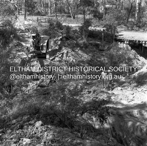
Negative - Photograph, J.A. McDonald, Henley Road at Watsons Creek, Mar. 1961
Henley Road at Watsons Creek Looking easterly along new alignment, 22 March 1961 C. Browns Excavator Contractor Wolf Cr PellingRecord of various Shire of Eltham infrastructure works undertaken during the period of 1952-1962 involving bridge and road reconstruction projects, sometimes with Eltham Shire Council Project Reference numbers quoted. It was during this period that a number of significant improvements were made to roads and new bridges constructed within the shire that remain in place as of present day (2022). In many situations, the photos provide a tangible visible record of infrastructure that existed throughout the early days of the Shire. The album was put together by or under the direction of the Shire Engineer, J.A. McDonald.infrastructure, shire of eltham, 1961-03, bend of islands, cr. charis pelling, henley road, henley road bridge, kangaroo ground, oxley bridge, watsons creek, w.e. wolf, bridge construction, road construction -
 Eltham District Historical Society Inc
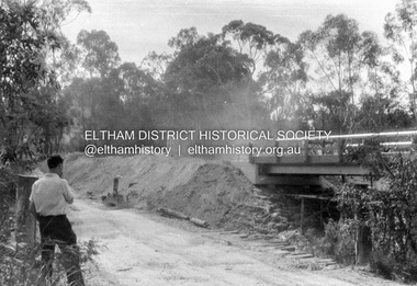
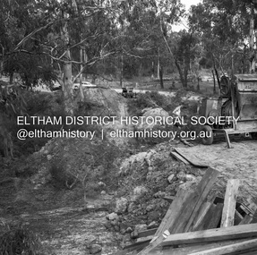
Negative - Photograph, J.A. McDonald, Henley Road at Watsons Creek, Apr. 1961
Henley Road at Watsons Creek looking easterly along centreline from west abutment Early April 1961Record of various Shire of Eltham infrastructure works undertaken during the period of 1952-1962 involving bridge and road reconstruction projects, sometimes with Eltham Shire Council Project Reference numbers quoted. It was during this period that a number of significant improvements were made to roads and new bridges constructed within the shire that remain in place as of present day (2022). In many situations, the photos provide a tangible visible record of infrastructure that existed throughout the early days of the Shire. The album was put together by or under the direction of the Shire Engineer, J.A. McDonald.infrastructure, shire of eltham, bend of islands, cr. charis pelling, henley road, henley road bridge, kangaroo ground, oxley bridge, watsons creek, w.e. wolf, bridge construction, road construction, 1961-04 -
 Eltham District Historical Society Inc
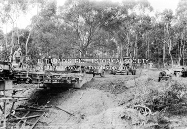
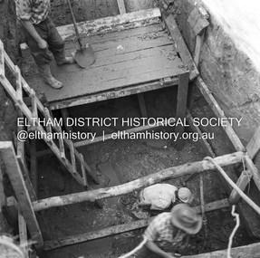
Negative - Photograph, J.A. McDonald, Henley Road at Watsons Creek, Apr. 1961
Henley Road at Watsons Creek showing excavation at western pier Rock at contract level, slight underground flow Early April 1961Record of various Shire of Eltham infrastructure works undertaken during the period of 1952-1962 involving bridge and road reconstruction projects, sometimes with Eltham Shire Council Project Reference numbers quoted. It was during this period that a number of significant improvements were made to roads and new bridges constructed within the shire that remain in place as of present day (2022). In many situations, the photos provide a tangible visible record of infrastructure that existed throughout the early days of the Shire. The album was put together by or under the direction of the Shire Engineer, J.A. McDonald.infrastructure, shire of eltham, bend of islands, cr. charis pelling, henley road, henley road bridge, kangaroo ground, oxley bridge, watsons creek, w.e. wolf, bridge construction, road construction, 1961-04 -
 Eltham District Historical Society Inc
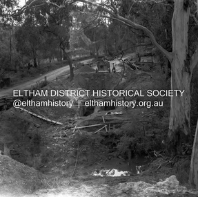
Negative - Photograph, J.A. McDonald, Henley Road at Watsons Creek, Apr. 1961
Henley Road at Watsons Creek looking westerly along centreline from east abutment Early April 1961Record of various Shire of Eltham infrastructure works undertaken during the period of 1952-1962 involving bridge and road reconstruction projects, sometimes with Eltham Shire Council Project Reference numbers quoted. It was during this period that a number of significant improvements were made to roads and new bridges constructed within the shire that remain in place as of present day (2022). In many situations, the photos provide a tangible visible record of infrastructure that existed throughout the early days of the Shire. The album was put together by or under the direction of the Shire Engineer, J.A. McDonald.infrastructure, shire of eltham, bend of islands, cr. charis pelling, henley road, henley road bridge, kangaroo ground, oxley bridge, watsons creek, w.e. wolf, bridge construction, road construction, 1961-04 -
 Eltham District Historical Society Inc
Negative - Photograph, J.A. McDonald, Henley Road at Watsons Creek, Apr. 1961
Henley Road at Watsons Creek looking westerly showing west abutment excavation Mid April 1961Record of various Shire of Eltham infrastructure works undertaken during the period of 1952-1962 involving bridge and road reconstruction projects, sometimes with Eltham Shire Council Project Reference numbers quoted. It was during this period that a number of significant improvements were made to roads and new bridges constructed within the shire that remain in place as of present day (2022). In many situations, the photos provide a tangible visible record of infrastructure that existed throughout the early days of the Shire. The album was put together by or under the direction of the Shire Engineer, J.A. McDonald.infrastructure, shire of eltham, bend of islands, cr. charis pelling, henley road, henley road bridge, kangaroo ground, oxley bridge, watsons creek, w.e. wolf, bridge construction, road construction, 1961-04 -
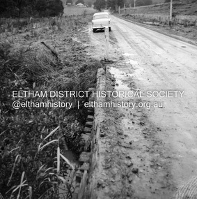
 Eltham District Historical Society Inc
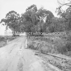
Negative - Photograph, J.A. McDonald, Sherbourne Road, Montmorency, c. July 1962
View looking west across Sherbourne Road to intersection of Rattray Road from present-day forecourt entrance to 7-Eleven Eltham service station The BP Service Station is now an Ampol Service Station (2022) Google Street View Apr.. 2022 https://goo.gl/maps/LM4APKCwj1ohBDPv5Record of various Shire of Eltham infrastructure works undertaken during the period of 1952-1962 involving bridge and road reconstruction projects, sometimes with Eltham Shire Council Project Reference numbers quoted. It was during this period that a number of significant improvements were made to roads and new bridges constructed within the shire that remain in place as of present day (2022). In many situations, the photos provide a tangible visible record of infrastructure that existed throughout the early days of the Shire. The album was put together by or under the direction of the Shire Engineer, J.A. McDonald.1962-07, ampol service station, bp service station, montmorency, rattray road, service station, sherbourne road, graders, infrastructure, public telephone box (red), reconstruction works, road construction, shire of eltham -
 The Beechworth Burke Museum
Audio - Oral History, Jennifer Williams, Mrs Val Mason, 5 January 2001
Mrs. Valerie (Val) Mason (1927-2019) was a local sheep farmer, business-woman, Beechworth shire councillor, and mother to five children. With her husband, Charles, Mrs. Mason developed and managed the Big Valley farm estate, at Everton, which is now part of a vineyard and farm stay. Mrs. Mason was instrumental in introducing a 'paddock to plate' philosophy and business model, opening a butcher shop on the farm in 1973. Concerned with improving infrastructure and developing economic opportunities in the region, Mrs. Mason successfully stood as a local council representative for South Riding in the United Shire of Beechworth, and later become the first woman Shire President in 1979. Mrs Mason was a member of the local Business and Professional Women's Club for 37 years. This oral history recording was part of a project conducted by Jennifer Williams in the year 2000 to capture the everyday life and struggles in Beechworth during the twentieth century. This project involved recording seventy oral histories on cassette tapes of local Beechworth residents which were then published in a book titled: 'Listen to what they say: voices of twentieth century Beechworth. These cassette tapes were digitised in July 2021 with funds made available by the Friends of the Burke.Mrs. Mason's story is historically significant for understanding economic and social changes in the Beechworth region during the latter half of the twentieth century. As a council representative, issues such as road and infrastructure modernisation and the transition from traditional government employment sectors, like Beechworth's care institutions, were challenges for local government. As a farmer and local employer, Mrs. Mason's story is testimony to the region's economic diversification as businesses like Big Valley farm shop helped shape the region's contemporary character. Mrs. Mason was among the first women to broach the traditionally all-male Beechworth Council Chambers and her story is socially significant for understanding the changing role of women in rural and regional Australia. This oral history recording offers interpretive capacity for social history themes and may be compared with other oral histories in the Burke Museum's collection. This oral history account is socially and historically significant as it is a part of a broader collection of interviews conducted by Jennifer Williams which were published in the book 'Listen to what they say: voices of twentieth-century Beechworth.' While the township of Beechworth is known for its history as a gold rush town, these accounts provide a unique insight into the day-to-day life of the town's residents during the 20th century, many of which will have now been lost if they had not been preserved.This is a digital copy of a recording that was originally captured on a cassette tape. The cassette tape is black with a horizontal white strip and is currently stored in a clear flat plastic rectangular container. It holds up 40 minutes of recordings on each side.Mrs Val Mason /listen to what they say, beechworth, oral history, burke museum, working women, trail blazers, farm to plate, farm shop, paddock to plate, woman farmer, united shire of beechworth, rural and regional women, beechworth's first woman shire president, women in leadership positions, women leaders, australian settlement history, settler societies, victorian gold rush, heritage tourism, culinary tourism, regional land use, indigo winery, farm stay, social history -
 Mission to Seafarers Victoria
Artwork, other - Art installation, Dagmar Udhe, Leap of the Heart: Ultramarine perspex oval shape by Dagmar Udhe, 1998
See document 1507Information for the brochure (http://www.artdes.monash.edu.au/globe/issue8/tbtitle.html) Construction in Process VI The Bridge, Melbourne Event: March 21-31 1998 Exhibition April 1-30 1998 During Construction in Process (CIP) III at Lodz, Poland in 1991, Emmett Williams and other participating artists initiated the idea of a biannual "performance" of their project in different cities and sites around the world. In the first instance, CIP was a response to the strictures of museum contained commodification of art practices and the dissolution of communism. And with this agenda in mind, their events affirm the active participation of international artists with local infrastructure and site specific materials. The organisation of the 1998 CIP in Melbourne, titled "The Bridge", took Richard Thomas, Katherine Armstrong, Gail Davidson and the legion of others over two years of dedication. And they brought off one of the most open-ended, logistically challenging conceptual events this metropolis has witnessed. The following photo essay provides a personal survey of the "The Bridge", as I saw it transpire around me. German artist Dagmar Udhe created several art installation in Swanson Dock and the Mission. This plaque was placed either in the dome or outside the dome. It may have been forgotten or left intentionally by the artist.PerformanceUltramarine ovoid shaped perspex plaque attached to the wall in the entrance of the Mission (Flinders Street).art installation, dagmar udhe, cultural events, artwork-paintings -
 Wodonga & District Historical Society Inc
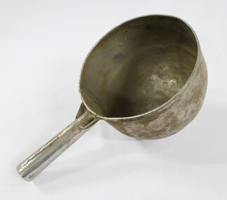
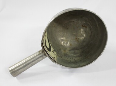
Functional object - Sand Scoop, North East Region Water Authority, Wodonga
The large aluminium sand scoop was used by Wodonga Waterworks Trust and it is part of the North East Region Water Authority collection in the Wodonga Historical Society. Wodonga's drinking water and wastewater were originally managed by the Wodonga Waterworks Trust, which was established in 1897, after Wodonga became a separate shire in 1876. In 1923 a Wodonga Waterworks Trust referendum to provide funding for new infrastructure to supply more water of better quality to Wodonga was passed. This included building the Wodonga Water Tower and it was completed in 1924. It supplied water to Wodonga until 1959, when it was drained and decommissioned after the No 1 Basin on Huon Hill was completed in 1958. In 1983 the Wodonga Waterworks Trust and the Wodonga Sewerage Authority became part of the Wodonga Council, and by 1989 a filtration plant at Huon Hill was completed, which provided filtered water of improved quality to Wodonga, in accordance with the World Health Organisation’s guidelines. In 1994 the Kiewa Murray Region Water Authority took over the Wodonga Council’s water and wastewater operations, and then in 1999 the Kiewa Murray Region Water Authority combined with the Ovens Region Water Authority and became the North East Region Water Authority or NERWA. NERWA then became known as North East Water. The sand scoop has local significance as part of the North East Region Water Authority collection donated to the Wodonga Historical Society. It also has wider state significance as a rare example of the equipment used in water management in Wodonga.Large aluminium scoop with a handle soldered on one side edge. Two holes and one indent in the end of the handle.north east region water authority, nerwa, wodonga waterworks trust, north east water, n.e. water, kiewa murray region water authority, sand scoop, metal scoop -
 Wodonga & District Historical Society Inc
Functional object - Sand Scoop, North East Region Water Authority, Wodonga
The large aluminium sand scoop was used by Wodonga Waterworks Trust and it is part of the North East Region Water Authority collection in the Wodonga Historical Society. Wodonga's drinking water and wastewater operations were originally managed by the Wodonga Waterworks Trust, which was established in 1897, after Wodonga became a separate shire in 1876. In 1923 a Wodonga Waterworks Trust referendum to provide funding for new infrastructure to supply more water of better quality to Wodonga was passed. This included building the Wodonga Water Tower and it was completed in 1924. It supplied water to Wodonga until 1959, when it was drained and decommissioned after the No 1 Basin on Huon Hill was completed in 1958. In 1983 the Wodonga Waterworks Trust and the Wodonga Sewerage Authority became part of the Wodonga Council. And by 1989 a filtration plant at Huon Hill was completed, which provided filtered water of improved quality to Wodonga, in accordance with the World Health Organisation’s guidelines. In 1994 the Kiewa Murray Region Water Authority took over the Wodonga Council’s water and wastewater operations, and then in 1999 the Kiewa Murray Region Water Authority combined with the Ovens Region Water Authority and became the North East Region Water Authority or NERWA. NERWA then became known as North East Water. The sand scoop has local significance as part of the North East Region Water Authority collection donated to the Wodonga Historical Society. It also has wider state significance as a rare example of the equipment used in water management in Wodonga.Large aluminium scoop with a handle soldered on one side edge and a repair riveted to the interior surface of the scoop where the handle is located. The repair is a piece of sheet metal, with what looks like the lower part of the letter 'S' on it.Lower part of the letter "S" on the repair riveted to the interior surface of the scoop.north east region water authority, nerwa, wodonga waterworks trust, north east water, n.e. water, kiewa murray region water authority, metal scoop, sand scoop -
 Melbourne Tram Museum
Film - Compact Diskette with video, Metlink, "Moving a Games City", 2006
DVD, with large format clear plastic cover with paper insert titled "Moving a Games City", sub-titled "A look at public transport during the Melbourne 2006 Commonwealth Games". Produced by Metlink, running time 17mins, has the games logo, Metlink., Yarra Trams, Connex, BusVic, VLine and Victorian Government logos on the rear. Features various elements of public transport access during the games, how they coped made changes, planning, Richmond station, Flinders St station, use of buses, passenger flows at Richmond, opening event, Ballarat station, VLine services, Doncaster Park and Ride and buses, Southbank depot, depot run outs, the Yarra Trams Fleet operations centre, Aquatic centre tram stops, St Kilda station, Southern Cross station, a very short segment of Z81, information campaigns, Metlink call centre, Rob Barnett of VLine, Dennis Cliche of Yarra trams, Peter Gibson of VLine, Digby Drew of Yarra Trams, John Stanley of BusVic, Mark Whitehead of VLine, Bernie Carolan of Metlink, Scott Martin of Dept. of Infrastructure, VLine, Mary Dimovski of Metlink, Andrew Kyriacou of Connex, Bruce Hughes of Connex.trams, tramways, commonwealth games, yarra trams, passenger services, metlink, connex, vline -
 Warrnambool and District Historical Society Inc.
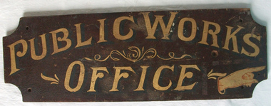
Sign - Public Works Office
This sign points has two different messages. The first states Public Works Office, which was operational in Victoria between 1855 and 1987 dealt with many aspects of the states infrastructure. It had many different reponsibilities and roles from building government accommodation and fit out of buildings, licences for unused roads and water ways, main roads and bridges, ports and harbour,and water supplies. Much of this work was managed through local offices such as the one at Warrnambool. The sign on the reverse which states Witnesses Waiting Room relates to the court house which is where this sign originated.The Warrnambool court house was built in 1870-71 by the Victorian Public Works department and it is possible that this sign relates to that period.It is one of a number of public buildings built in the period 1870-1890 including the Police station and stables and police quarters, the Post Office and drill Hall , all in the same vicinity. This building reflects the growth of the town and also the importance it held at the time from a state level. The building while no longer used as a court house is a building of significance to Warrnambool as well as to the state of Victoria, being one of six around the state which were built in free classical style. This sign denotes the waiting room for witnesses which was situated on the western side of the building.A tangible link which provides historical and social significance to Warrnambool.Rectangular wooden sign with rounded corners. There is text on both sides painted in gold paint with shadow in black. One side is a darker brown stain . There are screw holes in each corner.and one hole on left middle of sign. Rounded edge on one side.Side 1:Witnesses Waiting Room Side 2:Public Works Office.warrnambool, warrnambool court house, public works department warrnambool -
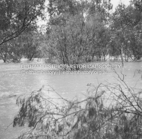
 Eltham District Historical Society Inc
Album - Photograph, J.A. McDonald, Eltham-Diamond Creek Road, 21 Oct. 1953
18 October 1956 Proposed upstream line over Diamond Creek from Diamond Creek sideRecord of various Shire of Eltham infrastructure works undertaken during the period of 1952-1962 involving bridge and road reconstruction projects, sometimes with Eltham Shire Council Project Reference numbers quoted. It was during this period that a number of significant improvements were made to roads and new bridges constructed within the shire that remain in place as of present day (2022). In many situations, the photos provide a tangible visible record of infrastructure that existed throughout the early days of the Shire. The album was put together by or under the direction of the Shire Engineer, J.A. McDonald.infrastructure, road construction, shire of eltham, bridge construction, eltham north, floods, floodwater, glen park bridge, 1956-10-18, diamond creek (creek), eltham, railway parade, wattletree road, wattletree road bridge -
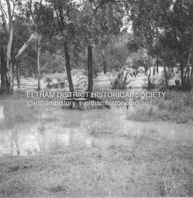
 Eltham District Historical Society Inc
Album - Photograph, J.A. McDonald, Eltham-Diamond Creek Road, 21 Oct. 1953
18 October 1956 Flooding on downstream line from Diamond Creek sideRecord of various Shire of Eltham infrastructure works undertaken during the period of 1952-1962 involving bridge and road reconstruction projects, sometimes with Eltham Shire Council Project Reference numbers quoted. It was during this period that a number of significant improvements were made to roads and new bridges constructed within the shire that remain in place as of present day (2022). In many situations, the photos provide a tangible visible record of infrastructure that existed throughout the early days of the Shire. The album was put together by or under the direction of the Shire Engineer, J.A. McDonald.infrastructure, road construction, shire of eltham, bridge construction, eltham north, floods, floodwater, glen park bridge, 1956-10-18, diamond creek (creek), eltham, railway parade, wattletree road, wattletree road bridge -
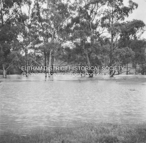
 Eltham District Historical Society Inc
Album - Photograph, J.A. McDonald, Eltham-Diamond Creek Road, 21 Oct. 1953
18 October 1956 New downstream alignment from Eltham sideRecord of various Shire of Eltham infrastructure works undertaken during the period of 1952-1962 involving bridge and road reconstruction projects, sometimes with Eltham Shire Council Project Reference numbers quoted. It was during this period that a number of significant improvements were made to roads and new bridges constructed within the shire that remain in place as of present day (2022). In many situations, the photos provide a tangible visible record of infrastructure that existed throughout the early days of the Shire. The album was put together by or under the direction of the Shire Engineer, J.A. McDonald.infrastructure, road construction, shire of eltham, bridge construction, eltham north, floods, floodwater, glen park bridge, 1956-10-18, diamond creek (creek), eltham, railway parade, wattletree road, wattletree road bridge -
 Eltham District Historical Society Inc
Album - Photograph, J.A. McDonald, Eltham-Diamond Creek Road, 21 Oct. 1953
18 October 1956 Proposed upstream line from Eltham sideRecord of various Shire of Eltham infrastructure works undertaken during the period of 1952-1962 involving bridge and road reconstruction projects, sometimes with Eltham Shire Council Project Reference numbers quoted. It was during this period that a number of significant improvements were made to roads and new bridges constructed within the shire that remain in place as of present day (2022). In many situations, the photos provide a tangible visible record of infrastructure that existed throughout the early days of the Shire. The album was put together by or under the direction of the Shire Engineer, J.A. McDonald.infrastructure, road construction, shire of eltham, bridge construction, eltham north, floods, floodwater, glen park bridge, 1956-10-18, diamond creek (creek), eltham, railway parade, wattletree road, wattletree road bridge -
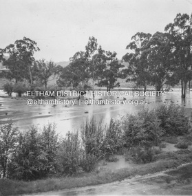
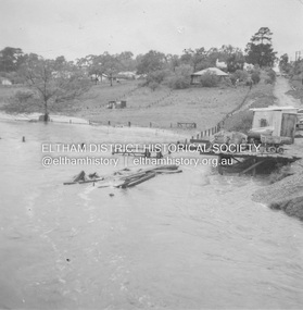 Eltham District Historical Society Inc
Album - Photograph, J.A. McDonald, Eltham-Greensborough Road, 18 Oct. 1956
Bridge Street Bridge Flooding on Waterfall’s Estate 18th October 1956 Looking east up to Main Road over what is now present-day Alistair Knox Park Beware!.. our rivers are rising (1956, October 19). The Argus (Melbourne, Vic. : 1848 - 1957), p. 1. Retrieved August 24, 2022, from http://nla.gov.au/nla.news-article84392304Record of various Shire of Eltham infrastructure works undertaken during the period of 1952-1962 involving bridge and road reconstruction projects, sometimes with Eltham Shire Council Project Reference numbers quoted. It was during this period that a number of significant improvements were made to roads and new bridges constructed within the shire that remain in place as of present day (2022). In many situations, the photos provide a tangible visible record of infrastructure that existed throughout the early days of the Shire. The album was put together by or under the direction of the Shire Engineer, J.A. McDonald.infrastructure, road construction, shire of eltham, bridge construction, bridge street bridge, eltham, eltham-greensborough road, 1956-10-18, diamond creek (creek), floods, floodwater, silver street bridge, alistair knox park, waterfall property