Showing 2890 items matching " settlers"
-
 Kew Historical Society Inc
Photograph, Floods in North Kew, 1971
Living with natural processes was frequently a challenge to early European settlers and later residents of what was in the 1850s administered by the Borondara Road Board. This was compounded by the area being bounded on three sides by rivers (Yarra River, Koonung Creek and Gardiner's Creek). In 1849, the historian James Bonwick recorded that "our district [Kew] suffered considerably. Mr Wade speaks of 80 acres, out of 100 acres of his cultivated paddock, covered by water." Newspapers continued to describe major flooding in Kew in 1863, 1869, 1878, 1880, 1889, 1891, 1916 and 1934. While the construction of the Upper Yarra dam in 1957 reduced the levels of flowing downstream, local and riverine floods continue.The Kew Historical Society's pictures and map collections testify to the impact of flooding in the district. They have historical importance in documenting the extent of flooding in the district and its affects on homes, services and recreation. Numerous photographs record flooding throughout the Twentieth Century.Floods in North Kew, 1971. Looking northeast towards Kilby Road from River Avenue. Annotation on reverse: map and date "8 Nov. 71 10.30am".floods (kew), yarra river, kew flood, kilby road flood -
 Kew Historical Society Inc
Photograph, Floods in North Kew, 1934
Living with natural processes was frequently a challenge to early European settlers and later residents of what was in the 1850s administered by the Borondara Road Board. This was compounded by the area being bounded on three sides by rivers (Yarra River, Koonung Creek and Gardiner's Creek). In 1849, the historian James Bonwick recorded that "our district [Kew] suffered considerably. Mr Wade speaks of 80 acres, out of 100 acres of his cultivated paddock, covered by water." Newspapers continued to describe major flooding in Kew in 1863, 1869, 1878, 1880, 1889, 1891, 1916 and 1934. While the construction of the Upper Yarra dam in 1957 reduced the levels of flowing downstream, local and riverine floods continue.The Kew Historical Society's pictures and map collections testify to the impact of flooding in the district. They have historical importance in documenting the extent of flooding in the district and its affects on homes, services and recreation. Numerous photographs record flooding throughout the Twentieth Century.Floods in North Kew, 1934. Vicinity of Willsmere Park.floods (kew) -
![Flooding at Chipperfield's Boathouse [East Kew], 1934](/media/collectors/550653872162f11fb04854aa/items/58cbaad5d0cec425b474bfb1/item-media/58cf6fbdd0cf9f331490feb0/item-fit-380x285.jpg) Kew Historical Society Inc
Kew Historical Society IncPhotograph, Flooding at Chipperfield's Boathouse, 1934
Living with natural processes was frequently a challenge to early European settlers and later residents of what was in the 1850s administered by the Borondara Road Board. This was compounded by the area being bounded on three sides by rivers (Yarra River, Koonung Creek and Gardiner's Creek). In 1849, the historian James Bonwick recorded that "our district [Kew] suffered considerably. Mr Wade speaks of 80 acres, out of 100 acres of his cultivated paddock, covered by water." Newspapers continued to describe major flooding in Kew in 1863, 1869, 1878, 1880, 1889, 1891, 1916 and 1934. While the construction of the Upper Yarra dam in 1957 reduced the levels of flowing downstream, local and riverine floods continue.The Kew Historical Society's pictures and map collections testify to the impact of flooding in the district. They have historical importance in documenting the extent of flooding in the district and its affects on homes, services and recreation. Numerous photographs record flooding throughout the Twentieth Century.Floods in North Kew, 1934. Chipperfield's Boathouse and the adding Moorings was located beside the Yarra River near the corner of Willsmere and Kilby Roads. The flood reached the roof of the Moorings, which can be seen in the photo.floods (kew), floods (kew) 1934, yarra river -
 Kew Historical Society Inc
Photograph, Floods in North Kew, 1934
Living with natural processes was frequently a challenge to early European settlers and later residents of what was in the 1850s administered by the Borondara Road Board. This was compounded by the area being bounded on three sides by rivers (Yarra River, Koonung Creek and Gardiner's Creek). In 1849, the historian James Bonwick recorded that "our district [Kew] suffered considerably. Mr Wade speaks of 80 acres, out of 100 acres of his cultivated paddock, covered by water." Newspapers continued to describe major flooding in Kew in 1863, 1869, 1878, 1880, 1889, 1891, 1916 and 1934. While the construction of the Upper Yarra dam in 1957 reduced the levels of flowing downstream, local and riverine floods continue.The Kew Historical Society's pictures and map collections testify to the impact of flooding in the district. They have historical importance in documenting the extent of flooding in the district and its affects on homes, services and recreation. Numerous photographs record flooding throughout the Twentieth Century.Floods in North Kew, 1934. Unidentified location on the Yarra Flood Plain at Kew.floods (kew) 1934, yarra river -
 Kew Historical Society Inc
Photograph, Floods in North Kew, 1934
Living with natural processes was frequently a challenge to early European settlers and later residents of what was in the 1850s administered by the Borondara Road Board. This was compounded by the area being bounded on three sides by rivers (Yarra River, Koonung Creek and Gardiner's Creek). In 1849, the historian James Bonwick recorded that "our district [Kew] suffered considerably. Mr Wade speaks of 80 acres, out of 100 acres of his cultivated paddock, covered by water." Newspapers continued to describe major flooding in Kew in 1863, 1869, 1878, 1880, 1889, 1891, 1916 and 1934. While the construction of the Upper Yarra dam in 1957 reduced the levels of flowing downstream, local and riverine floods continue.The Kew Historical Society's pictures and map collections testify to the impact of flooding in the district. They have historical importance in documenting the extent of flooding in the district and its affects on homes, services and recreation. Numerous photographs record flooding throughout the Twentieth Century.Floods in North Kew, 1934. Chipperfield's Boat House under flood.floods (kew) 1934, yarra river, chipperfield's boat house -
 Kew Historical Society Inc
Photograph, Floods in North Kew, 1934
Living with natural processes was frequently a challenge to early European settlers and later residents of what was in the 1850s administered by the Borondara Road Board. This was compounded by the area being bounded on three sides by rivers (Yarra River, Koonung Creek and Gardiner's Creek). In 1849, the historian James Bonwick recorded that "our district [Kew] suffered considerably. Mr Wade speaks of 80 acres, out of 100 acres of his cultivated paddock, covered by water." Newspapers continued to describe major flooding in Kew in 1863, 1869, 1878, 1880, 1889, 1891, 1916 and 1934. While the construction of the Upper Yarra dam in 1957 reduced the levels of flowing downstream, local and riverine floods continue.The Kew Historical Society's pictures and map collections testify to the impact of flooding in the district. They have historical importance in documenting the extent of flooding in the district and its affects on homes, services and recreation. Numerous photographs record flooding throughout the Twentieth Century.Floods in North Kew, 1934. Flood near the lagoon (Billabong?)floods (kew) 1934, yarra river -
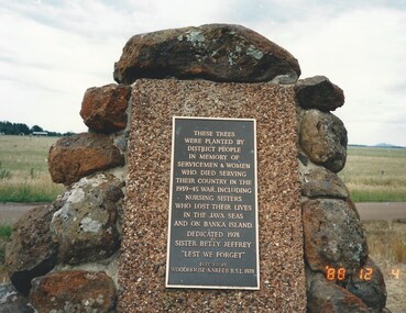 Melbourne Legacy
Photograph, Widow Daytrip, 1988
An outing by the widows club to visit a memorial to servicemen and women from the Woodhouse-Nareeb area. The photos show a group of ladies who attended and the plaques and memorial board. The plaque says 'These trees were planted by district people in memory of servicemen and women who died serving their country in the 1939-45 war, including nursing sisters who lost their lives in the java seas and on Banka Island. Dedicated 1978, Sister Jeffery 'Lest We Forget'. The memorial board says 'World War 2 Soldier Settlement Woodhouse-Nareeb area. The settlers served with Navies, Armies, and Air Forces of the British Commonwealth, many of their wives served with the Womens' Auxillaries and nursing services.'A record of the types of activities Legacy provided as a physical and social outlet for widows.Colour photo x 5 of an outing to a memorial in 1988.Photos are marked as 4 December 1988.widows, widows outing, memorial, daytrip -
 Warrnambool and District Historical Society Inc.
Document (item) - Allansford land purchase document, Land purchase document, 1864
This paper contains details of the purchase of Lot 11 in the Township of Allansford in 1864. The purchaser, Isabella McQueen, was born in Scotland in 1814, married Alexander McQueen in 1850 and with her family migrated to Australia in 1854. After her husband's death in 1860 Isabella purchased the land in Frank Street, Allansford in 1864 and lived in a house there with family members until her death in 1895. She had purchased the land, via an agent, from John Allan who with his brothers were the pioneer European settlers in the Allansford area. John Allan had created the township of Allansford in the mid 1850s by sub-dividing the land he owned there. John Allan moved to the Gippsland area late in 1864. This piece of paper is most significant as it is an original record of an early transaction in the history of Allansford, a town now part of Warrnambool City.Mrs isabella McQueen Bot. of Robert Gregory As agent for J M Allan Esq. Lot no. 11 as marked and described on the Plan of Subdivision of the Township of Allansford. For which I have received the um of five pounds Stg. being the purchase money of same. Robert Gregory 21st October 1864allansford history, john allan, isabella mcqueen -
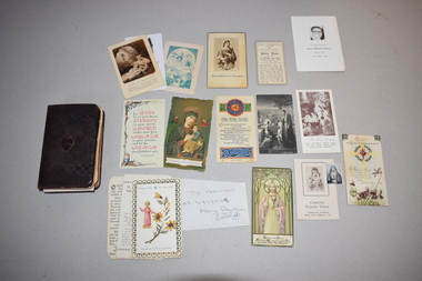 Warrnambool and District Historical Society Inc.
Book, Charles Eason, The Treasury of the Sacred Heart, C1920
This book of prayers was given by the Warrnambool Sisters of Mercy to Dorothy Ardlie on the occasion of her 12th birthday. The Sisters of Mercy came to Warrnambool in 1872 and established St. Mary’s Convent School, Wyton in North Warrnambool (re-named St. Ann’s in 1888). This school merged with the Christian Brothers College in 1990 to form the present-day Emmanuel College. The Sisters of Mercy ceased active involvement with the school in the 1990s. Dorothy Ardlie (1910-1993) and her sister Agnes Ardlie (1915-1993) were the daughters of Arthur and Ethel Ardlie of Warrnambool, the granddaughters of the prominent Warrnambool lawyer William Ardlie and his wife Mary and the great granddaughters of John and Mary Ardlie, pioneer settlers in Warrnambool. This book and the loose cards are interesting mementoes of Dorothy Ardlie, a member of a prominent Warrnambool family in the 20th century and of the Sisters of Mercy, an order of nuns that has been important in Warrnambool’s educational history. This is a book of 138 pages with a brown leather cover and gilt edging along the sides of the pages. The front and back cover and spine are embossed with two decorative patterns. The front cover has an embossed heart with flames and a cross and the spine has gold lettering. Some of the pages are loose and some have been re-attached to the binding using adhesive tape. Some of the pages are stained. The book contains black printing and there is one black and white illustration. In the pages of the book were 29 small cards, scraps of paper etc. These are now kept with the book but in a separate folder. Most of these are of a devotional nature – prayers, images of saints etc. Wishing dear Dorothy a very happy birthday with much love from the Sisters of Mercy 26th April 1922ardlie family, sisters of mercy, history of warrnambool -
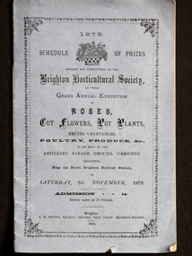 City of Moorabbin Historical Society (Operating the Box Cottage Museum)
Booklet - Schedule Booklet, horticultural prizes, "1879 Schedule of Prizes Brighton Horticultural Society", 1879
This booklet from 1879 was given to the Moorabbin Historical Society when the Robert Keys Leader Cup Trophy, 1882-1883 was re-discovered at 'Box Cottage' Museum in 2009. The Leader Cup Trophy, MAV 00001, is also itemised in this booklet (p9) The Leader Newspaper offered the 'Silver Cup, value Five Guineas for the best fruit garden in the Brighton District. The Proprietors of the English, Scottish and Australian Chartered Bank offered an second prize of three Guineas Commencing in 1856, the Brighton Horticultural Society only disbanded in 2009, and most of their archival holdings were given to the Brighton Historical Society. This booklet gives a good idea of the large varieties of plants, poultry and the skills of the pioneer settlers of the Brighton District.This Booklet describes the Schedule of Prizes for the 1879 Grand Annual Exhibition of the Brighton Horticultural Society in Brighton Victoria. The Booklet was donated to the Moorabbin Historical Society in 2009 upon the disbanding of the Brighton Horticultural Society..at that time. The Moorabbin Historical Society possesses the 1882 'Leader Cup Trophy' (cat 00001) presented to Robert Keys for the best Fruit Garden. This booklet is kept in the same cabinet as the Robert Key's Silver Trophy. After Henry Dendy's Special Survey in 1841 allotments of land were sold or rented to pioneer settlers who developed market gardens , fruit gardens and poultry farms in the Brighton area. Their produce was sold at the St Kilda and Melbourne Markets for the growing population of MelbourneBooklet with mauve paper cover and 16 pages listing the Schedule of prizes for the 1879 annual exhibition of the Brighton Horticultural Society to be held in Brighton, Victoria."1879/ SCHEDULE OF PRIZES/OFFERED FOR COMPETITION BY THE/ BRIGHTON HORTICULTURAL SOCIETY,/ AT THEIR/ GRAND ANNUAL EXHIBITION/ OF / ROSES,/ CUT FLOWERS, POT PLANTS,/ FRUITS, VEGETABLES,/ POULTRY, PRODUCE, &c.,/TO BE HELD IN THE/ ARTILLERY PARADE GROUND, CRESCENT, / BRIGHTON,/ Near the North Brighton Railway Station, / ON / SATURDAY, 8th NOVEMBER, 1879./ ADMISSION 1s. / Doors open at 2 o'clock. / Brighton: / G. H. ORFORD, MACHINE PRINTER, NEXT NORTH BRIGHTON STATION. / 1879 ;melbourne, keys robert, trophy, leader newspaper, leader cup, brighton, silver, moorabbin, bentleigh, markets, dendy henry, st kilda, bent thomas, market gardens, brighton horticultural society, fruit gardens, banks chartered -
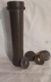 Mont De Lancey
Domestic object - Cookie Press and Icing Set, Unknown
Women in early settler days and 1900's managed the household and had to be self sufficient and were skilful cooks providing meals for their families. Normal daily life involved washing clothes, ironing, cooking meals and baking cakes, scones, bread, and pastries whilst caring for the children and making and mending the family's clothes. This was the precursor to the current hand held machine for making forcer biscuits. The metal cylinder was filled with biscuit dough and the wooden piece pushed down inside the cylinder to force the dough through different shaped, detachable, apertures to produce various shaped biscuits. The wooden forcer is missing from this set. The tin base has a movable end for cleaning the wooden press. An incomplete rusted long tubular tin cookie or icing press with four pattern attachments. There is no handle or forcer. There are four original shaped profiles which can be interchanged tied together with brown string. The tube was to be filled with biscuit/pastry mixture and a wooden press was used to force the mixture out of it. biscuit cutters, kitchenware, kitchen equipment, pastry cutters -
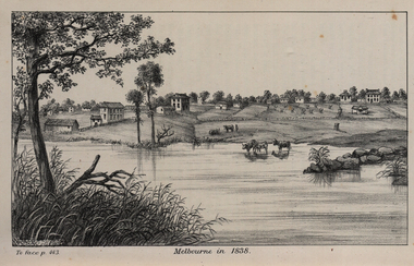 Federation University Historical Collection
Image, John Helder Wedge, Melbourne in 1838, 1938
The following information is from http://melbourneday.com.au/about.html, accessed 30 August 2016 Melbourne was founded on 30 August 1835 by settlers who sailed from Van Diemen’s Land (Tasmania) aboard the schooner Enterprize. They landed on the north bank of the Yarra River and established the first permanent settlement, close to where the Immigration Museum at the Old Customs House — on the corner of William and Flinders Streets — stands and the place today known as Enterprize Park. Melbourne Day Committee was established to help correct the record about the founding of Melbourne and celebrate its anniversaries. The settlers came from Launceston in search of sheep-grazing land. Land had become expensive and there had long been stories told by whalers and sealers working in Bass Strait of fertile land to the north. This was the southern part of the colony of New South Wales, which the Colonial Government did not want settled at that time. After the Henty family crossed Bass Strait and settled at Portland in 1834 others quickly followed. The north bank was chosen because a small waterfall, or rapids, stopped further progress up the river. The waterfall also separated the tidal movement, providing a vital supply of fresh water. The site had previously been noted by the colony of New South Wales' surveyor, Charles Grimes, in 1803. The north bank also offered more stable, suitable ground. The people of the Kulin nation are the traditional owners of the land that became Melbourne — including the Boonwurrung, Woiwurrung, Taungurung and Djadjawurrung people, who gathered in this place for ceremonies and cultural activities. The topsail schooner Enterprize you see today is a full-size replica of the one that brought the settlers and has become a symbol of Melbourne Day. Her keel was laid at Polly Woodside Maritime Museum in 1991, and the $2.5 million, 27m vessel was launched by Felicity Kennett on 30 August, 1997, at Hobsons Bay. The original ship was bought by John Pascoe Fawkner in April 1835 specifically to search for a suitable place for a settlement in the Port Phillip District. After helping establish Melbourne, the original Enterprize continued operating as a coastal trading vessel for a number of years. She eventually disappeared off the shipping register in 1847, having been wrecked on a sand bar in the Richmond River in northern NSW, with the loss of two lives. The replica is managed by the Enterprize Ship Trust, a not-for-profit organisation. The first settlers were those on board the Enterprize — her crew and passengers. They were John Lancey , master mariner and Fawkner’s representative; Enterprize's captain, Peter Hunter; George Evans, plasterer/builder; carpenters William Jackson and Robert Hay Marr; Evan Evans, George Evans’ servant; and Fawkner’s servants ploughman Charles Wise, general servant Thomas Morgan, blacksmith James Gilbert and his pregnant wife, Mary. And Mary's cat! Enterprize set sail on her historic voyage from Launceston on July 21, 1835, stopping at George Town in northern Tasmania where creditors detained Fawkner. He was therefore not part of the first trip to Melbourne. Enterprize then left on August 1 under the command of captain Hunter. The expedition was led by Lancey, Fawkner's delegate. The party first considered Western Port and the eastern side of Port Phillip for a place to settle, before deciding on the Yarra’s north bank — known today as Enterprize Park. On Sunday, August 30, they disembarked and began to erect shelter, build a store and clear land to grow food, thus starting the permanent European settlement of Melbourne.Image of the fledgling town of Melbourne on the banks of the Yarra River. melbourne, yarra river, john helder wedge -
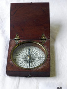 Flagstaff Hill Maritime Museum and Village
Instrument - Compass, c. 1839
This magnetic compass is a good size to fit easily into a person's pocket or personal luggage and is protected from knocks by its wooden case. It could have been used for reference when travelling on land or sea. There is no visible manufacturer's mark, which may mean that it was not of high monetary value. Leith is a district of Edinburgh in the country of Scotland, the U.K. It was once the Port of Edinburgh and many migrant ships departed from here bound for the Australian colony. It had a busy shipbuilding industry, with wet and dry docks. It appears from the inscription on the case "Chas Gray, LEITH, 1839" that this pocket compass once belonged to Charles M. Gray (Chas is a common abbreviation for the name Charles). The inscription coincides with the name, place and date that the Western Victorian pioneer Charles M. Gray left Scotland and arrived in Australia. Charles Gray was born in Anstruther, Scotland, in 1818. His family was connected with the Royal Marines, which may have created his nautical instruments such as this pocket compass. Charles Gray arrived in Hobson's Bay on 15 June 1839 on the ship “Midlothian”. That same ship had departed from Leith, Scotland on February 15th 1839. Did Charles Gray acquire the pocket compass in Leith, perhaps as a gift or a souvenir of his motherland? Charles Gray was an early squatter and went on to become a very successful settler as a sheep pastoralist in the Western District of what is now Victoria (originally the colony of New South Wales). He and his wife had a large property called “Nareeb Nareeb”, Green Hill Creek District (now Glenthompson), Victoria, from 1840-1886. He was also a local Councillor and Justice of the Peace, and had an interest in the local indigenous people; he named his property after their tribe. Charles returned to England in 1890 and died there in 1905. Charles Gray had written an account in 1890 of his life at Nareeb Nareeb, called Western Victoria in the Forties: "REMINISCENCES OF A PIONEER The Western District in the 1840's By Charles Gray" , a valuable historical reference to colonial Victoria. His book was published by the Hamilton Spectator in 1932. Charles Gray's photograph is one of 713 historical photographs of early Victorian settlers, created as a montage by Thomas Foster Chuck in 1872. The State Library of Victoria holds the framed montage titled “The Explorers and Early Colonists of Victoria”. To qualify for inclusion on this montage the Settlers must have arrived in Victoria before 1843. Charles Gray's photograph is number 349! The pocket compass is associated with Charles Gray, one of the early squatters and settlers in Western Victoria, possibly given to him as a parting gift on his emigration to Van Diemans land in 1839. The item is very significant as it's connection with one of Victoria's early pioneers is well provenanced by the inscriptions on the wooden case. Pocket compass, brass, set into a square wooden case with hinged lid and small hook catch. Compass is marked with 360 degrees and compass points and has two pointers; one to show magnetic north and one to set the direction of travel. Hinges are triangular and inset into the wood. The lid has an attached brass plaque with the inscription "Chas Gray, Leith, 1839" (It likely belonged to Charles Gray, Leith, UK, who migrated to Port Philip Australia in 1839 and became a successful pastoralist.) “Chas Gray / LEITH / 1839” engraved on brass plaque on lid.flagstaff hill, warrnambool, shipwrecked coast, flagstaff hill maritime museum, maritime museum, shipwreck coast, flagstaff hill maritime village, great ocean road, magnetic compass, pocket compass, charles m. gray, chas gray, migrrant from leith 1839, charles gray anstruther, scottland, ship midlothian 1839, squatter western victoria, settler western victoria, hobson's bay port phillip australia, charles gray nareeb nareeb - green hill creek district, western victoria in the forties: reminiscences of a pioneer by charles m. gray 1890, leith edinburgh u.k., western victoria in the forties: reminiscences of a pioneer - montage by thomas foster chuck 1872, charles gray, reminiscences of a pioneer, the western district in the 1840's, compass, scientific instrument, nautical instrument, direction, directional compass, navigation -
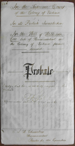 Warrnambool and District Historical Society Inc.
Document - William Cox Probate 1899, 1899
Tait collection: item 19 of 62 This is an 1899 document giving Will and Probate details of William Cox who died in Warrnambool in March 1899. He was a farmer residing in Moore Street Warrnambool at the time of his death at the age of 83. He left real estate to the value of £425 and personal estate to the value of £412 to Gwenllian Williams who may have been his sister or niece. A Mr and Mrs Williams were also living in the Moore Street house at the time of Cox’s death. His executors were Thomas Goodall, a law clerk who managed the office of the lawyer Ernest Chambers in Warrnambool and John Ward, a pioneer settler in Warrnambool and a shopkeeper in Jamieson Street in 1899. No other details are available on William Cox. This is an interesting document as it gives details of the Will and Probate belonging to a local Warrnambool person, William Cox. The lawyer dealing with the document was Ernest Chambers who had legal offices in Warrnambool, Port Fairy and Koroit at the end of the 19th century and the beginning of the 20th century. This document has been passed on to successive lawyers occupying legal chambers in the Kepler Street building and that is where the document was held until passed on to the Warrnambool and District Historical Society in 2014.This is an 1899 piece of parchment paper folded in two with handwritten material on three sides of the paper. The seal of the Supreme Court of the Colony of Victoria is attached with blue ribbon and there are two stamps, one blue one of the Colonial Bank in Warrnambool and the other a red one of the Master in Equity of the Supreme Court in Melbourne. Two of the pages have ruled black lines. The writing is very clear but the pages are a little stained.In the Supreme Court of the Colony of Victoria In its Probate Jurisdiction In the Will of William Cox late of Warrnambool in the Colony of Victoria farmer deceased; Probate; I certify there is no duty payable on this probate (signature) Officer under Section 96 of act No 106; E J W Chambers Warrnambool Proctors for the Executorswilliam cox, ernest chambers, john ward, thomas goodall, tait collection -
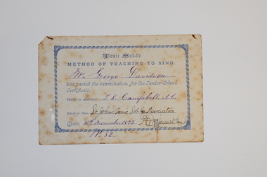 Warrnambool and District Historical Society Inc.
Certificate - Singing certificate, St. John's Tonic Sol-Fa Association, 1877
This card was presented to George Davidson when he passed the Junior School examination held by St. John's Tonic Sol-Fa Association in 1877. The Tonic Sol-Fa was a technique used for teaching sight singing, invented in the 18th century and further developed, popularised and used extensively by singing teachers in the 19th century. The St. John's Tonic Sol-Fa Association was an extension of the choir of St. John's Presbyterian Church in Warrnambool and the conductor (and the teacher whose name is on this card) was T. L.Campbell. He was a well-known singing and music teacher in Warrnambool in the second half of the 19th century and specialized in the teaching of the viola, violin and violincello. George Davidson (1860-1941) was the son of John and Isobel Davidson, pioneer settlers in the Warrnambool district.This card is of some interest as a memento of the music scene in Warrnambool in the second half of the 19th century with references to T.L. Campbell, a music teacher, George Davidson, a pupil and a school of music, St. John's Tonic Sol-Fa AssociationThis is a small white card with a blue scroll border and blue printing on one side and printed information on the other side. The card has handwritten details in ink. It is stained, torn at one edge and has signs of silverfish damage.Tonic Sol-Fa Method of Teaching to Sing - Mr George Davidson has passed the examination for the Junior School Certificate. Teacher or Assistant: T.L. Campbell A.C. School or Class: St. John's Tonic Sol-Fa Association. Date: 30th November 1877 No. 52st john's warrnambool tonic sol-fa association, t.l.campbell warrnambool music teacher, george davidson warrnambool -
 Warrnambool and District Historical Society Inc.
Administrative record - Sales Docket Book, Cramond & Dickson Store, Warrnambool, 1960s
This docket book has been used to enter sales from the Cramond and Dickson department store in Warrnambool and to provide the customer with a copy of the invoice. It dates from about the 1960s. John Cramond and James Dickson, two pioneer settlers in Warrnambool, established the Carmond and Dickson store in Warrnambool in 1855, initially selling groceries, drapery and ironmongery but later, at the corner of Liebig and Timor Streets, this department store sold mainly clothing and drapery. In the 1860s a Cramond and Dickson store was opened in London. The Cramond and Dickson store, a most important business in Warrnambool, operated until 1973. The docket book was printed by Lamson Paragon, a British firm that was established in Australia in 1897 and specialized in printing sales docket books with a carbon paper insert.This docket book is of interest as a memento of the Cramond and Dickson Store, one of the most significant businesses ever to have operated in WarrnamboolThis is a docket book containing 46 pages of white printed sheets bound with green tape and enclosed in a green patterned paper cover on the front and a piece of cardboard on the back. The pages have ruled black lines, red and black print and an image in red of a building. Some of the pages have been used and removed. At the front of the pages are two sheets of carbon paper and tissue paper for copying purposes.Cramond & Dickson General Drapers and Importers Warrnambool 3280 Lamson Paragoncramond & dickson warrnambool, john cramond warrnambool, james dickson warrnambool, warrnambool businesses, lamson paragon printing firm -
 Warrnambool and District Historical Society Inc.
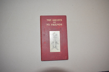
Book, Dow and Lester, The Ghosts of My Friends, 1920s
This item came from the estate of Dorothy and Agnes Ardlie of Warrnambool. It is a type of autograph book where the signatures are used to form inkblots, thus creating patterns which in this case are called the ‘ghosts’ of those signing. The making and interpreting of ink blots became popular in the late 19th century and this autograph book created by Cecil Henland is a quirky example of this craze. The autograph book belonged to Agnes Ardlie and was apparently given to her on her 13th birthday (1928). Dorothy Ardlie (1910-1993) and Agnes Ardlie (1915-1993) were the daughters of Arthur and Ethel Ardlie of Warrnambool, the granddaughters of the prominent Warrnambool lawyer, William Ardlie and his wife Mary and the great granddaughters of John and Mary Ardlie, pioneer settlers in Warrnambool. This book is of great interest as a good example of an early 20th century style of autograph book using the signatures to form ink blots. It also has local provenance as the signatures/blots are mostly those of an Ardlie family and other early to mid 20th century Warrnambool personalities.This is a book of 50 pages. The cover is dark red with the inkblot or ‘ghost of a celebrated general’ in black and white in the middle of the front cover. This inkblot is reprinted on the second page. The front cover and spine have gold printing. The book originally had 48 blank pages with a fold down the middle and printed space at the top and bottom for a date and a name. This book has 19 blank pages and the others are filled with ink blots formed by writing a signature along the fold and then folding over the sheet without blotting to get patterns called in this book, ‘ghosts’. The book has a signature and an inscription handwritten in black ink, a page of instructions, and a poem called ‘Ghosts’. To Agnes with love from Mickie Sept 5th 1928 Agnes Marianne Ardlie ardlie family, history of warrnambool -
 Warrnambool and District Historical Society Inc.
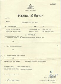
Document, Australian Army Statement of Service, C 1976
He served from December 1941 to July 1942 in the Citizen Military Forces and from July 1942 to September 1944 in the Australian Imperial Forces. His reason for discharge was reserved occupation. He held the rank of corporal in 26th Motor regiment. He was born in Colac 19/11/1919 to Ernest Swan and Daisy Johnson. He died 04/08/2009 and is buried at the Warrnambool cemetery. During his life he farmed a soldiers’ settlers block in the Grasmere area, north of Warrnambool. The soldiers' settlement program was instigated after both world wars whereby land was made available to returning soldiers. Some of the land was Crown land and some was acquired. This document is an official statement of his service.This document has social significance and interest as it is representative of thousands of local men who served in World War 2. It is a link also to the Soldiers' settlement programCream paper with black text. Personal details of Ernest Henry Swan have been typed into fields. text in the centre of the reverse.Signed E H Swan. date of issue is 11/08/1976.Army number VX88010.warrnambool, e h swan, e h swan statement of service -
 Melton City Libraries
Pamphlet, The Pinkerton Forest Project, 1992
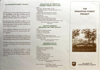
"The Pinkerton family is remembered in Melton in part due to the historic graves of the original settler, Margaret Pinkerton, and four of her grandchildren, which were marked by a memorial cairn in 1931. Changes to sewage flood zoning in the area in the 1990s necessitated that these burials be relocated. Members of the Melton & District Historical Society oversaw a project to relocate the Pinkerton graves and cairn 200 metres from their original site to their current resting place at Mount Cottrell. This relocation ceremony took place on 8 November 1992, with the participation of local school students and with Pinkerton descendants playing a central role. This occasion also marked the opening of the Pinkerton Forest Project, which saw 50 hectares of degraded woodland in Surbiton Park protected for regeneration". Pamphlet about the relocation of the Pinkerton graveslandscapes of significance, local identies, local special interest groups, pioneer families -
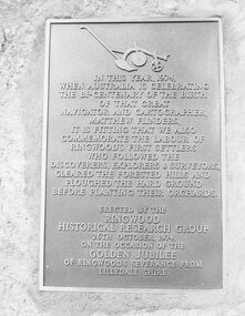 Ringwood and District Historical Society
Photograph, Plaque, Ringwood Library, commemorating Golden Jubilee of Ringwood's severance from Lilydale Shire. 1974
Black and white photograph of plaque set in rock outside Library.Plaque reads: IN THIS YEAR, 1974, WHEN AUSTRALIA IS CELEBRATING THE BI-CENTENARY OF THE BIRTH OF THAT GREAT NAVIGATOR AND CARTOGRAPHER, MATTHEW FLINDERS, IT IS FITTING THAT WE ALSO COMMEMORATE THE LABOUR OF RINGWOOD'S FIRST SETTLERS WHO FOLLOWED THE DISCOVERERS, EXPLORERS & SURVEYORS, CLEARED THE FORESTED HILLS AND PLOUGHED THE HARD GROUND BEFORE PLANTING THEIR ORCHARDS. ERECTED BY THE RINGWOOD HISTORICAL RESEARCH GROUP, 26TH OCTOBER, 1974 ON THE OCCASION OF THE GOLDEN JUBILEE OF RINGWOOD'S SEVERANCE FROM LILYDALE SHIRE Typed below photograph: "1974 - Plaque Ringwood Library." Written on rear of backing sheet: "Before the plaque was finally fitted in I had a new 1974 ten cent piece slipped in behind it. R. Pullin, Archivist, RHR Group." -
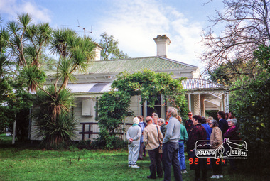
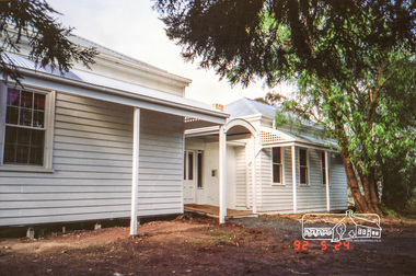 Eltham District Historical Society Inc
Photograph, Allwood House, Hurstbridge, Eltham Heritage Tour, 24 May 1992, 24/05/1992
ELTHAM HERITAGE TOUR The Society excursion on 24th May 1992 was arranged by David Bick, leader of the team carrying out the Shire's heritage study. David selected a number of sites or buildings identified in the study, some of them lesser known components of the Shire's heritage. The tour commenced at the Eltham Shire Office at 10.00 am. Travel was by private car and mini-bus with stops at about twelve locations for commentary by David.It included a short walk in Hurstbridge and lunch at Kinglake. Highlights of the tour included: - 10 am Leave from Shire Offices - 3 Important Trees - A Physical Link to Eltham's First Settlers - Toorak Mansion Gates - A Surviving Farm House - An Intact Circa 1900 Main Street - First Settlers - Gold Miners, and Timber-getters - An Early Hotel - A Pioneering Homestead - Changing Eltham Shire - 20th Century - 4 pm Afternoon Tea and Finish Tour Extract from ELTHAM CULTURAL HERITAGE TOUR (Newsletter No. 85, July 1992, by Bettina Woodburn) "At the crossroads stands Allwood House with its well laid out garden. The original owners, the Hurst family, ran a nursery; the aligned palms, the cactus clumps, the introduced trees and shrubs show the plants then in fashion. On the other corners stand an old corrugated iron garage; a restaurant, designed and built 1980, but by using old materials it tries to retain the rustic character of its surroundings; and open space where a two storied Wineshop/Saloon once stood. The old Bank, now in the grounds of Allwood House has been moved a few doors down the street."Record of the Society's history and activities and highlighting various aspects of the Heritage Study undertaken by David Bick used to create the future heritage overlay for the Shire of Eltham and later Nillumbik Shire.Roll of 35mm colour negative film, 4 stripsKodak Gold 100 5095shire of eltham historical society, activities, heritage tour, hurstbridge, allwood house -
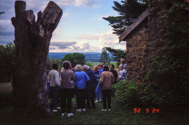 Eltham District Historical Society Inc
Photograph, Kangaroo Ground War Memorial, Eltham Heritage Tour, 24 May 1992, 24/05/1992
ELTHAM HERITAGE TOUR The Society excursion on 24th May 1992 was arranged by David Bick, leader of the team carrying out the Shire's heritage study. David selected a number of sites or buildings identified in the study, some of them lesser known components of the Shire's heritage. The tour commenced at the Eltham Shire Office at 10.00 am. Travel was by private car and mini-bus with stops at about twelve locations for commentary by David.It included a short walk in Hurstbridge and lunch at Kinglake. Highlights of the tour included: - 10 am Leave from Shire Offices - 3 Important Trees - A Physical Link to Eltham's First Settlers - Toorak Mansion Gates - A Surviving Farm House - An Intact Circa 1900 Main Street - First Settlers - Gold Miners, and Timber-getters - An Early Hotel - A Pioneering Homestead - Changing Eltham Shire - 20th Century - 4 pm Afternoon Tea and Finish Tour Extract from ELTHAM CULTURAL HERITAGE TOUR (Newsletter No. 85, July 1992, by Bettina Woodburn) "Now we drove through stands of pines to the Kangaroo Ground Lookout Tower, a most unusual War Memorial, World War I. The tower and a shed/residence (it had a chimney) were built from local sandstone. Below to the south and east of Melbourne spread 'suburbia'. Close by the landscape seemed so contrived - English fields and hedgerows! Although only about twenty inches deep, the soil of this ancient volcano, its crater lost under subsequent weathering, was rich, deserving the name of "Garden Hill". Now native trees are taking over again. In Kangaroo Ground itself stand the inevitable Store, School and Church - and two Norfolk pines and a monkey puzzle tree."Record of the Society's history and activities and highlighting various aspects of the Heritage Study undertaken by David Bick used to create the future heritage overlay for the Shire of Eltham and later Nillumbik Shire.Roll of 35mm colour negative film, 4 stripsKodak Gold 100 5095shire of eltham historical society, activities, heritage tour, kangaroo ground, kangaroo ground tower, war memorials, kangaroo ground memorial -
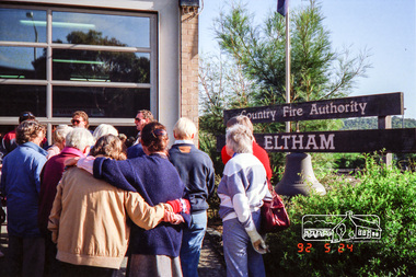 Eltham District Historical Society Inc
Photograph, Eltham Fire Station, Main Road, Eltham Heritage Tour, 24 May 1992, 24/05/1992
ELTHAM HERITAGE TOUR The Society excursion on 24th May 1992 was arranged by David Bick, leader of the team carrying out the Shire's heritage study. David selected a number of sites or buildings identified in the study, some of them lesser known components of the Shire's heritage. The tour commenced at the Eltham Shire Office at 10.00 am. Travel was by private car and mini-bus with stops at about twelve locations for commentary by David.It included a short walk in Hurstbridge and lunch at Kinglake. Highlights of the tour included: - 10 am Leave from Shire Offices - 3 Important Trees - A Physical Link to Eltham's First Settlers - Toorak Mansion Gates - A Surviving Farm House - An Intact Circa 1900 Main Street - First Settlers - Gold Miners, and Timber-getters - An Early Hotel - A Pioneering Homestead - Changing Eltham Shire - 20th Century - 4 pm Afternoon Tea and Finish Tour Extract from ELTHAM CULTURAL HERITAGE TOUR (Newsletter No. 85, July 1992, by Bettina Woodburn) "Commencing with a quick walk to see the magnificent bell at the Eltham Fire Station, we then 'drove along Arthur Street. Here were examples of what constitutes the building environment of Eltham. Massed among the wattles and eucalypts were golden cypress and pines; No. 50 was an exotic 'old English' manor-house; No. 93 had bluestone gateposts, from Fenton Road Toorak (as with Montsalvat, using re-cycled building material was very much the trend); past the natural Reserve dedicated to the artist Walter Withers, a plaque on a huge boulder; and on both sides houses in the various modes - timber with wrought iron decor, brick-some more recent than others, decades of 'suburbia'."Record of the Society's history and activities and highlighting various aspects of the Heritage Study undertaken by David Bick used to create the future heritage overlay for the Shire of Eltham and later Nillumbik Shire.Roll of 35mm colour negative film, 4 stripsKodak Gold 100 5095eltham, main road, shire of eltham historical society, activities, heritage tour, cfa -
 Eltham District Historical Society Inc
Photograph, Allwood House, Hurstbridge, Eltham Heritage Tour, 24 May 1992, 24/05/1992
ELTHAM HERITAGE TOUR The Society excursion on 24th May 1992 was arranged by David Bick, leader of the team carrying out the Shire's heritage study. David selected a number of sites or buildings identified in the study, some of them lesser known components of the Shire's heritage. The tour commenced at the Eltham Shire Office at 10.00 am. Travel was by private car and mini-bus with stops at about twelve locations for commentary by David.It included a short walk in Hurstbridge and lunch at Kinglake. Highlights of the tour included: - 10 am Leave from Shire Offices - 3 Important Trees - A Physical Link to Eltham's First Settlers - Toorak Mansion Gates - A Surviving Farm House - An Intact Circa 1900 Main Street - First Settlers - Gold Miners, and Timber-getters - An Early Hotel - A Pioneering Homestead - Changing Eltham Shire - 20th Century - 4 pm Afternoon Tea and Finish Tour Extract from ELTHAM CULTURAL HERITAGE TOUR (Newsletter No. 85, July 1992, by Bettina Woodburn) "At the crossroads stands Allwood House with its well laid out garden. The original owners, the Hurst family, ran a nursery; the aligned palms, the cactus clumps, the introduced trees and shrubs show the plants then in fashion. On the other corners stand an old corrugated iron garage; a restaurant, designed and built 1980, but by using old materials it tries to retain the rustic character of its surroundings; and open space where a two storied Wineshop/Saloon once stood. The old Bank, now in the grounds of Allwood House has been moved a few doors down the street."Record of the Society's history and activities and highlighting various aspects of the Heritage Study undertaken by David Bick used to create the future heritage overlay for the Shire of Eltham and later Nillumbik Shire.Roll of 35mm colour negative film, 4 stripsKodak Gold 100 5095shire of eltham historical society, activities, heritage tour, hurstbridge, allwood house -
 Eltham District Historical Society Inc
Photograph, Kangaroo Ground War Memorial, Eltham Heritage Tour, 24 May 1992, 24/05/1992
ELTHAM HERITAGE TOUR The Society excursion on 24th May 1992 was arranged by David Bick, leader of the team carrying out the Shire's heritage study. David selected a number of sites or buildings identified in the study, some of them lesser known components of the Shire's heritage. The tour commenced at the Eltham Shire Office at 10.00 am. Travel was by private car and mini-bus with stops at about twelve locations for commentary by David.It included a short walk in Hurstbridge and lunch at Kinglake. Highlights of the tour included: - 10 am Leave from Shire Offices - 3 Important Trees - A Physical Link to Eltham's First Settlers - Toorak Mansion Gates - A Surviving Farm House - An Intact Circa 1900 Main Street - First Settlers - Gold Miners, and Timber-getters - An Early Hotel - A Pioneering Homestead - Changing Eltham Shire - 20th Century - 4 pm Afternoon Tea and Finish Tour Extract from ELTHAM CULTURAL HERITAGE TOUR (Newsletter No. 85, July 1992, by Bettina Woodburn) "Now we drove through stands of pines to the Kangaroo Ground Lookout Tower, a most unusual War Memorial, World War I. The tower and a shed/residence (it had a chimney) were built from local sandstone. Below to the south and east of Melbourne spread 'suburbia'. Close by the landscape seemed so contrived - English fields and hedgerows! Although only about twenty inches deep, the soil of this ancient volcano, its crater lost under subsequent weathering, was rich, deserving the name of "Garden Hill". Now native trees are taking over again. In Kangaroo Ground itself stand the inevitable Store, School and Church - and two Norfolk pines and a monkey puzzle tree."Record of the Society's history and activities and highlighting various aspects of the Heritage Study undertaken by David Bick used to create the future heritage overlay for the Shire of Eltham and later Nillumbik Shire.Roll of 35mm colour negative film, 4 stripsKodak Gold 100 5095shire of eltham historical society, activities, heritage tour, kangaroo ground, kangaroo ground tower, war memorials, kangaroo ground memorial -
 Orbost & District Historical Society
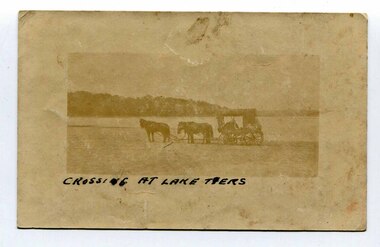
black and white photograph, late 19th - early 20th century
In the late 19th century in the Orbost area roads were just bush tracks which generally were unsuitable for any type of vehicular traffic so were traversed mainly by horseback. As the settlement grew, a weekly mail service from Cunninghame (Lakes Entrance) was estab-lished. The settlers had to carry the mail for three months and each took a turn as mailman during that time. The first coach was driven by Mr Alex Hall. Eventually a daily mail service was set up and many drivers included B. Sutherland, W. Middleton, Jonson Bros., J. Mitchell, F. Newport, J. Geddes, A. Coulson, Bert Cessor, H. Weekes and A. Barthile. (info. from Newletter August 2007) This photograph is one of A. Coulson’s Coach crossing the Sand Bar at Lake Tyers.This is a pictorial record of very early transport in East Gippsland.A very faded small postcard / photograph of a horse and cart crossing a beach.on front in black writing - " Crossing at Lake Tyers" on back - "A Coulson"lake-tyers transport coulson-coaches -
 Orbost & District Historical Society
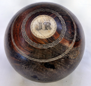
bowl
Owned by Alexander Cameron who arrived in Australia in 1853. Alexander Cameron ("Big Alex") was an early settler on the Snowy River flats. he worked the paddle steamer Cheviot for a while, having a wharf and sheds on the Snowy River in 1900. Later moved to Cann River. The Bowling Club was founded in 1929, by a group of farmers and businessmen. They set about providing a sporting icon for the town. Six rinks were constructed on the current site using horse drawn scoops and drags. The "Back to Orbost” 1937 book, describes the greens as "a bit rough for the first two seasons but now compare favourably with most country greens". Funds for the construction were raised by the issue of debentures at £5 each, and subscriptions were £1/1s/0d ($2.10). (info. Margaret Smith)Alec Cameron was a prominent early Orbost settler. The Orbost Bowling Club was established in 1929.Wooden lawn bowl with wooden circles on top and bottom. Top- I Bottom - J.R.22recreation sport lawn-bowls cameron-alexander -
 Orbost & District Historical Society
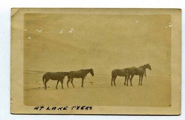
black and white photograph, late 19th century - early 20th century
In the late 19th century in the Orbost area roads were just bush tracks which generally were unsuitable for any type of vehicular traffic so were traversed mainly by horseback. As the settlement grew, a weekly mail service from Cunninghame (Lakes Entrance) was estab-lished. The settlers had to carry the mail for three months and each took a turn as mailman during that time. The first coach was driven by Mr Alex Hall. Eventually a daily mail service was set up and many drivers included B. Sutherland, W. Middleton, Jonson Bros., J. Mitchell, F. Newport, J. Geddes, A. Coulson, Bert Cessor, H. Weekes and A. Barthile. (info. from Newletter August 2007) This photograph is one of A. Coulson’s Coach crossing the Sand Bar at Lake Tyers.This is associated with early transport in East Gippsland.A black / white postcard photograph of four horses alone on a beach.on front - At Lake Tyers on back - "Mr A. Coulson, coach driver, Orbost"lake-tyers coulson-coach-driver transport-horse-drawn -
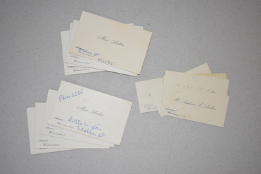 Warrnambool and District Historical Society Inc.
Visiting Cards, 1930s?
These items came from the estate of the Misses Ardlie, (Dorothy and Agnes). They are visiting cards for their father and themselves. Dorothy Ardlie (1910-1993) and Agnes Ardlie (1915-1993) were the daughters of Arthur and Ethel Ardlie of Warrnambool, the granddaughters of the prominent Warrnambool lawyer, William Ardlie and his wife Mary and the great granddaughters of John and Mary Ardlie, pioneer settlers in Warrnambool. Visiting cards were used for business purposes or when making formal calls to other families. These cards show two residences of Dorothy and Agnes – Aroona, 19 Princess Street and Little Wyton at 3 Nelson Street. Wyton was the name of one of Captain John Ardlie’s ships. The fact that the Misses Ardlie had visiting cards are an indication that they were two of the more affluent and high profile members of Warrnambool society in the 20th century. These cards are of interest, firstly as an example of a visiting card used in the early to mid 20th century and secondly as mementoes of the Ardlie family of Aroona, Warrnambool. .1 These are 9 identical white visiting cards for Agnes Ardlie. The cards are rectangular in shape and have black cursive printing. .2 These are 2 white visiting cards for Miss Ardlie. They are rectangular in shape and have black cursive printing and alterations in blue ink handwriting. .3 These are 5 white visiting cards for Arthur Ardlie. One card is very discoloured. The cards are rectangular in shape and have black cursive printing and alterations in blue ink handwriting on two of them. ardlie family,, warrnambool, warrnambool lawyer, -
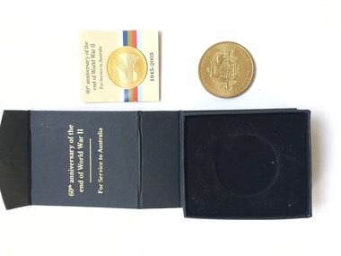 Warrnambool and District Historical Society Inc.
Medal, 60th Anniversary of the end of WW11, 2005
This medal was issued to commemorate the end of World War 2 and was issued to eligible living veterans or their widows/widowers.It comes in a black card and fabric lined box. It has been issued by the Department of Veterans Affairs.This medal was awarded to Ernest Henry Swan. He served from December 1941 to July 1942 in the Citizen Military Forces and from July 1942 to September 1944 in the Australian Imperial Forces. His reason for discharge was reserved occupation. He held the rank of corporal in 26th Motor regiment. He was born in Colac 19/11/1919 to Ernest Swan and Daisy Johnson. He died 04/08/2009 and is buried at the Warrnambool cemetery. During his life he farmed a soldiers’ settlers block in the Grasmere area, north of Warrnambool. A common object with over 300000 minted but with a link to a local person and commemorating an event of world importance.Gold metal round medal with Australian coat of Arms on one side and stylised image of outline of Australia on the obverse side. Mounted in black card box.World War 11 Service to Australia. World War 11 60years 1945-2005warrnambool, ernest swan, 60th anniversary medallion ww2