Showing 2474 items matching " township"
-
 Sunbury Family History and Heritage Society Inc.
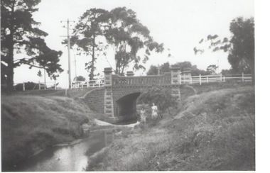
Photograph, Rosa McCall, Moonee Ponds Creek, 1949
The single arched stone bridge spans the Moonee Ponds Creek in the former Old Broadmeadows Township, now Westmeadows. The historic bridge is in Fawkner Street, and has a heritage classification. The Moonee Ponds Creek flows from the upper reaches of Greenvale and flows into the Yarra at Docklands.The stone bridge over the Moonee Ponds Creek was erected in 1869 and replaced a less substantial one.A black and white print of a non-digital photograph of a stone single-span bridge spanning a creek. White post-and-rail fence has been constructed ion either side of the bridge. Pine trees are growing on then creek banks.moonee ponds creek, old broadmeadows township, bridges, fawkner street, westmeadows -
 Kiewa Valley Historical Society
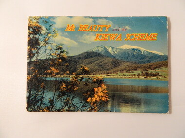
Postcard (fold out) - Mt Beauty and the Kiewa Scheme, Victoria, Mt Beauty and the Kiewa Scheme, c1960s
S. K Pearce owned shops in Mt Beauty and Tawonga. The postcard was used for tourism to attract visitors to the Mt Beauty township and the Kiewa Scheme on the Bogong High Plains. The postcard gives a brief history of the town and area both created by the State Electricity Commission of Victoria.The photos are historically significant and include prominent places in the Kiewa Valley, Mt Beauty and the Bogong High Plains. S. K Pearce was a prominent shop owner in the area having shops in Tawonga and in Mt Beauty as seen in one of the photos. The postcards are of interest as they are an example of advertising for tourism in the 1960's.Fold out postcards including a panel on information on Mt Beauty and the Kiewa Scheme, 12 colored labelled photos, an address & letter written in black biro. Multiple copies.Letter from Roma to 'Dad and Chris'. Their address in Bayswater. Postage stamp from Mount Beautymt beauty, kiewa hydro electric scheme, s. k. pearce, tourism -
 Kiewa Valley Historical Society
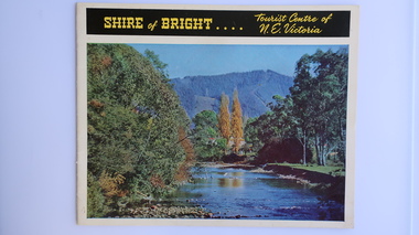
Brochure - Shire of Bright, Shire of Bright Tourist Centre of N.E. Victoria, Pre 1966
Bright and the surrounding towns were developing a large tourism industry which the Shire of Bright continues to promote, encouraging tourists to visit throughout the year. This high quality brochure has magnificent photos with a map showing the area and the distance (in miles) from the centre - the township of Bright.This brochure is promoting the Shire of Bright encouraging tourism in the area. This is important for the Shire as tourism is the main industry for the Shire. It is interesting to see how tourism has changed (or not) in the area.14 pages on glossy paper including colored and black and white photos. The front cover has the title at the top with yellow print on black background. Below the title is a large colored photo of a river, autumn trees and mountain. The back cover is a large colored photo of a man amongst the snow gums in the snow. The towns covered are Bright, Wandiligong, Eurobin, Mt Buffalo, McKay Creek Power Station, The Kiewa Hydro Electric Scheme, Mt Beauty, Kiewa, Bogong including tourist destinations in these areas and their surrounds.tourism; mt beauty; the kiewa valley; bright shire -
 Phillip Island and District Historical Society Inc.
Newspaper clippings, 1888
Extract from The Argus, Monday July 9th 1888 - Griffiths Point Saturday at a Public meeting of the inhabitants of Griffiths Point, held this afternoon to consider the most appropriate name for the newly proclaimed township there. It was unanimously decided on the suggestion of Mr Fraser that it should be called San Remo.Extract from The Argus, Monday July 9th 1888local history, documents, newspapers, griffiths point, san remo, , black & white newspaper clipping, miss elms san remo -
 Hume City Civic Collection
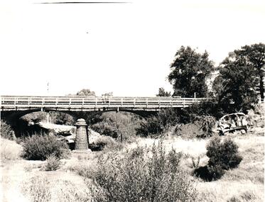
Photograph, 1960s
The two-arched bluestone bridge which spans the Jacksons Creek at the east end of Sunbury township, was built in 1857 and continued to be used as a road bridge on the main Sunbury Road-Macedon Street until the early 1970s when a wider bridge replaced the original bluestone bridge.A black and white photograph of a two- arched bluestone bridge which spans a dry creek bed. A bulldozer is on the riverbank on the RHS of the photograph.bridges, bluestone bridges, jacksons creek, harris, thomas lascelles, macedon street, george evans collection -
 Sunbury Family History and Heritage Society Inc.
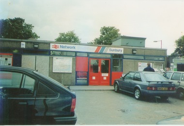
Photograph, September 1996
The photograph shows the railway station at Sunbury in Surrey in the United Kingdom. The town of Sunbury in Victoria was named after the English township of Sunbury-on-Thames in Middlesex by the Jackson Brothers who took up land in Sunbury, Victoria. The area was originally known as Koora Kooracup by the Wurundjeri people.Sunbury in Victoria like many other settlements in Australia were given names of towns in the United KingdomA coloured photograph of a railway station with three cars parked outside the building, which has grey walls and scarlet and blue trims. There are framed maps and notices on the exterior walls. -
 The Beechworth Burke Museum
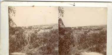
Photograph - Stereoscopic Photograph
This photograph offers a view of Beechworth, located at the foot of the Victorian Alps. It captures the gorge and native vegetation in the foreground, with the Beechworth township visible in the middle, where the hospital is marked with an arrow. Distant hills form the backdrop. Originally settled c1839, Beechworth was officially proclaimed a town in 1856.This photograph is historically significant as it captures the landscape of Beechworth, providing valuable insight into the town's visual and historical character.Two sepia-toned square photographs showing the view of a town with trees in the foreground and hills in the far distance, mounted.Obervse: Above the right photograph there is an arrow pointing down. Reverse: 97.2195/ View across the Gorge/ looking over Beechworth/ (Hospital under arrow)/ 84-110-1/ A03082beechworth, town, landscape, ovens district, stereoscopic -
Bendigo Historical Society Inc.
Map - GOORNONG, Revised 5/06/1926
Map: Town of Goornong, Parish of Goornong, County of Bendigo ( number 153 in Map Cupboard 1)map, bendigo, township, goornong, county of bendigo -
 Clunes Museum
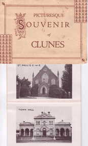
Photograph, THE ROSE STEREOGRAPH CO. ARMADALE. VIC
DONATED TO MUSEUMPICTURESQUE SOUVENIR OF CLUNES, FOLDER CONTAINING PHOTOS, CONSISTING OF VIEW OF CLUNES, ST. PAUL'S CHURCH OF ENGLAND, SOLDIERS MEMORIAL, QUEEN'S PARK, TOWN HALL, QUEEN'S BRIDGE, ST. THOMAS'S ROMAN CATHOLIC CHURCH.ALSO CLUNES FROM MINE HEAD AND POST OFFICE.local history, photography, photographs, clunes, township -
 Lakes Entrance Historical Society
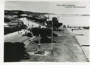
Postcard - Esplanade Lakes Entrance, 1945c
Original from wallet of miniature postcards produced by Bulmer, two copies. 01419.1 and .2 Also two enlargements 17 x 25 cmBlack and white small format postcard of Esplanade, taken from the WW2 Air Observers Spotting Tower. In the foreground is the Cenotaph erected 1922 on the grass verge between road and lake. Trimmed WW1 Cypress trees also on verge. Cars and truck on highway all travelling in easterly direction. Houses and businesses on north side of road, Princes Highway, which follows the margin of the lake shore. Lakes Entrance VictoriaThe Esplanade Lakes Entrancetownship, waterfront, transport, world war 1939 - 1945, world war 1914-1918 -
 Lakes Entrance Historical Society
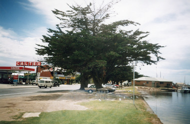
Photograph - Caltex Service Station, 1998
Date made 2 February 1998Colour photograph of Esplanade, showing the Caltex Service Station, Cunninghame Arm Nursery with Sallys Restaurant upstairs, cypress trees on verge between road and lake, Ocean Rescue headquarters on bank of lake with rescue vessel moored at jetty, glimpse of Eastern Wharf in background. Lakes Entrance Victoriatownship, waterfront, memorials, retail trade, emergency services -
 Lakes Entrance Historical Society
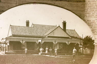
Photograph - Coates family, 1920c
This image was photographed from an original oval framed photograph in possession of Mrs Vi Symmons, nee Coate, daughter of Joseph and Isabella Coate. The Coate home was moved to Kalimna West 1960-1970c.Sepia photograph of the family home of Joseph and Isabella Coate, situated on Esplanade. It shows a tile roofed California style bungalow residence, two internal chimneys each topped with twin chimney pots. Veranda has decorative frieze under roof, seven men standing in front of house, five in workman's aprons. Lakes Entrance Victoriatownship, architecture, people, clothing, room display -
 Lakes Entrance Historical Society
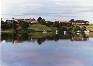
Photograph - Lakes Entrance, Tambo Shire, 1994 c
Also second identical copyColour photograph of a section of the North Arm adjacent to Ferndale Parade, shows the rear view of six houses, five small boats moored at lake edge. Lakes Entrance Victoriajetties, houses, waterways, boats and boating, township -
 Lakes Entrance Historical Society
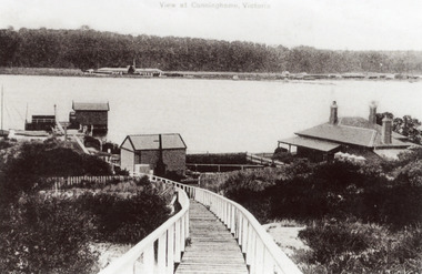
Photograph - New Works, 1910c
Also black and white copy 12.5 x 18 cm with smear of purple ink in top left hand corner, purchased from Helen ClothierTinted black and white photograph showing boardwalk from New Works Jetty over the sand dunes with small shed on jetty, small one room Boole Poole school on right of boardwalk and harbour master's house on right. Club Hotel on opposite foreshore and town on far right. Kalimna escarpment in background, at Lakes Entrance, Victoria.View of Cunninghame Victoriaboardwalk, waterways, ships and shipping, township, topography -
 Clunes Museum
Photograph, 1971
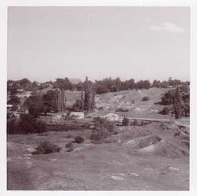
BLACK AND WHITE PHOTOGRAPH PANORAMIC VIEW OF CLUNES. PHOTO TAKEN FROM SPOT WHERE GOLD WAS FIRST DICOVERED LOOKING SOUTH TOWARDS ANLICAN CHURCH.BLACK AND WHITE PHOTOGRAPH PANORAMIC VIEW OF CLUNES. PHOTO TAKEN FROM SPOT WHERE GOLD WAS FIRST DICOVERED LOOKING SOUTH TOWARDS ANLICAN CHURCH.local history, photography, photographs, mining, township -
 Lakes Entrance Historical Society
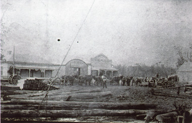
Photograph - Harbeck's Store, 1910
Second copy 18 x 25 cm, purchased from Win Burnett 1992Black and white photograph of activities in front of Harbeck's Store. Long telegraph poles are lying in foreground, stacked railway sleepers behind them, eight horse team harnessed to log wagon in front of general store, grain store and residence. Two smaller wagons, horses and men in image. Lakes Entrance Victoriaretail trade, township, animals, clothing, room display -
 Lakes Entrance Historical Society
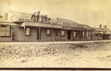
Photograph - Kiora House, 1920c
Also copy enlargement 12 cm x 19 cm Kiora House was purchased by Mrs C Beveridge from Mrs Begg. (Original building, A Murray's store, then Barkes store, before Barkes built near Post Office). House to the left purchased later, balcony built over veranda, this place removed and demolished for family home to be built later.Sepia toned photograph of Kiaora House. Houses on the left and the right. Sandy or Gravel roadway in front of building. Sand at the lake front in foreground of photo. People standing on upper balcony. Lakes Entrance VictoriaKiaora Housearchitecture, township, tourism, room display, local history -
 Lakes Entrance Historical Society
Photograph - Boat Harbour, 1925c
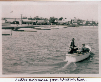
Black and white photograph of the western end of Esplanade, showing guest houses, businesses, Police Station, Methodist Church, cars parked in front of buildings, Bluestone wall at edge of lake, timber groynes for sand control. On lake a small motor boat containing two men. Lakes Entrance VictoriaLakes Entrance from western end.police, religion, waterfront, boats and boating, township -
 Lakes Entrance Historical Society
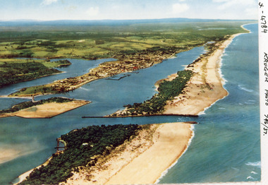
Photograph - Lakes Entrance, Kruger A F, 1960c
Colour photograph aerial view of the entrance from Bass Strait to the Gippsland Lakes, Australia. Shows extension to Bullock Island, town of Lakes Entrance, Cunninghame Arm and North Arm. Lakes Entrance Victoriaaerial photograph, islands, waterways, topography, township -
 Lakes Entrance Historical Society
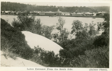
Postcard - the Central Hotel, butcher shop, bluestone wall at lake edge, and two small jetties. Sand hills and natural vegetation in foreground. Lakes Entrance Victoria, 1930c
Other black and white copy 17 x 25 01417.1Black and white postcard of the town, taken from the southern shore of the lake, showing residences, the Central Hotel, butcher shop, bluestone wall at lake edge, and two small jetties. Sand hills and natural vegetation in foreground. Lakes Entrance VictoriaLakes Entrance from the South Sidetownship, waterfront, retail trade, hotels, shops -
Lakes Entrance Historical Society
Book, Haskell, Arnold L, Waltzing Matilda - A Background to Australia - The Diggers Edition, 1943
A view of Australia and Australians seen through the eyes of the author during his years of travel and association with Australians. Illustrated with photographs. IndexedRuth Clarksocial history, township, natural history, topography, law -
 Lakes Entrance Historical Society
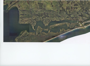
Photograph - Lakes Entrance, Gippsland Ports, 2006 c
Colour aerial photograph showing the entrance to Gippsland Lakes from Bass Strait westward to Reeves Channel Shaving Point at Metung through Lake King to Tambo River Gippsland Lakes Victoriaaerial photograph, waterways, township, topography, lakes entrance -
 Lakes Entrance Historical Society
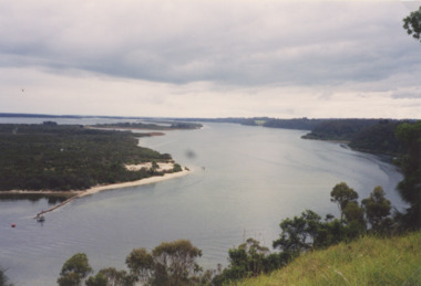
Photograph - Jemmys Point Lakes Entrance, Tidy Town Committee, 1996 c
Also a second similar photograph number 03875.1 size 10 x 15 cmColour photograph taken from Jemmys Point looking west through the Gippsland Lakes to Metung with Rigby, Fraser and Flannagan Islands to the south Kalimna Victoriaaerial photograph, township, topography, waterways, jemmys point lakes entrance -
 Lakes Entrance Historical Society
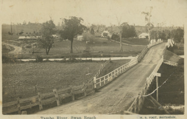
Postcard, Vogt Bairnsdale, Tambo River Swan Reach, 1920 c
Note on back to Ella from her brother Don dated 1920Black and white postcard showing the old Swan Reach bridge over the Tambo River looking east. Buildings L to R Riverslea guesthouse and school with high pitched roof. Swan Reach VictoriaTambo River Swan Reachwaterways, boats and boating, township, guesthouses, bridges -
 Bendigo Historical Society Inc.
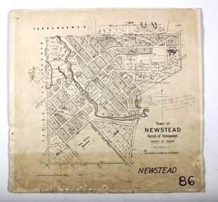
Map - NEWSTEAD, 15/10/1912
Map: Town of Newstead, Parish of Strangways, County of Talbotmap, talbot, township, newstead, county of talbot -
 Lakes Entrance Historical Society
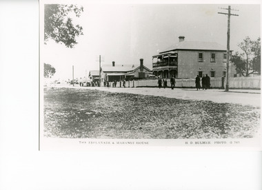
Photograph - Maranui House, Bulmer H D, 1920c
Copied from photographic copy purchaed from East Gippsland Historical SocietyBlack and white photograph of the Esplanade, showing Maranui House, a double storied weatherboard building with hipped roof, balcony over veranda at front. Picket fence across front, men and women in winter fashion on footpath. Other buildings in photo are Police Station and Bellevue Guest House. Lakes Entrance VictoriaThe Esplanade and Maranui Houseguesthouses, township, architecture, clothing, fences -
 Lakes Entrance Historical Society
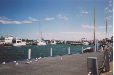
Photograph - Cunninghame Arm Lakes Entrance Victoria c2006, M Holding, 2006
walkway beside Cunninghame Arm looking towards Peels booking office, boats moored at jetties and beside walkway Lakes Entrance Victoria . Also two colour photographs taken from walkway beside Cunninghame Arm looking east 04260.1 and 04260.2 size 10 x 15 cmColour photograph taken from walkway beside Cunninghame Arm looking towards Peels booking office, boats moored at jetties and beside walkway Lakes Entrance Victoria. Also two colour photographs taken from walkway beside Cunninghame Arm looking east 04260.1 and 04260.2 size 10 x 15 cm c2006 township, waterfront, roads and streets, vehicles, boats and boating -
 Lakes Entrance Historical Society
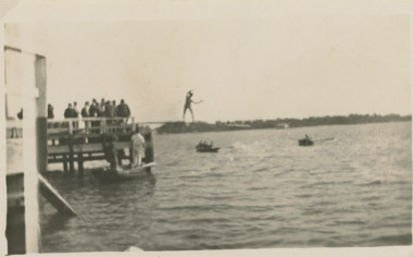
Photograph - Regatta on Cunninghame Arm Lakes Entrance Victoria, 1939
Black and white photograph taken of the greasy pole contest during the Regatta on Cunninghame Arm Lakes Entrance Victoria. Also seven black and white photographs taken at same event showing pillow fight, horse barrel race and yacht race plus black and white photograph township, waterways, gippsland lakes, jetties, events -
 Lakes Entrance Historical Society
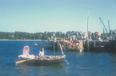
Photograph - Centenary Celebrations Lakes Entrance Victoria. c1958, 1958
Henley on the Lakes taken from Eastern Wharf during Centenary Celebrations Lakes Entrance Victoria. c1958 Colour photograph of decorated boats for Henley on the Lakes taken from Eastern Wharf during Centenary Celebrations Lakes Entrance Victoria. c1958. Similar colour photograph at Regatta 04274.1 . Plus 3 Black and white photos township, people, waterways, gippsland lakes, celebrations -
Clunes Museum
Map, DEPARTMENT OF LANDS AND SURVEY
MAP OF ALLOTMENTS IN CLUNESlocal history, documents, map, township, clunes