Showing 1305 items
matching commercial road
-
 Wodonga & District Historical Society Inc
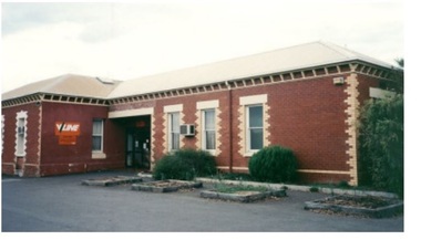
Photograph - One Fine Day - decision to move Wodonga Railway Line, 2000
On December 1, 2000 it was finally announced that the railway line would be moved away from the centre of the Wodonga CBD after many years of lobbying. Since its opening in 1873 the railway line had crossed High Street, originally called Sydney Road. The railway had bisected the city with level crossing gates frequently stopping the flow of traffic as trains passed through. The Wodonga Rail Bypass project moved Wodonga station from the original central location to a position on a new line on the northern edge of the town. Not only did this release land in the middle of the city for commercial and public use, but also eliminated 10 level crossings. The project actually commenced in 2008 with the last passenger train passing through Wodonga on 8 November 2008. On 23 July 2010, the new rail bypass was opened, and the original line through Wodonga closed. In this image the decision is celebrated by the Member for Indi, the Honourable Lou Lieberman, Deputy Prime Minister and Transport Minister John Anderson, Wodonga Mayor Cr. Graham Crapp and General Manager of Uncle Ben's Australia, Mr Bob Kennedy.This image commemorates a significant occasion in the development of the Central Business District of Wodonga, Victoria.A framed photo of four men celebrating the decision to move the railway out of the centre of Wodonga as well as an image of the from page of the Border Mail newspaper.wodonga railway, wodonga rail bypass, city of wodonga -
 Wodonga & District Historical Society Inc
Book - Trees on Farms, Australian Farm Management Society, September 1980
This publication documents the proceedings of a conference held by the Australian Farm Management Societyat Wodonga CIvic Centre on September 11, 1980. It focussed on economic and technical aspects of commercial plantations, agro-forestry and shelter belts on farms. Topics include the Victorian Farm Forestry Loan Scheme, a Farmer's experience in growing and processing pines, and local outlets and future prospects for timber in Australia.non-fictionThis publication documents the proceedings of a conference held by the Australian Farm Management Societyat Wodonga CIvic Centre on September 11, 1980. It focussed on economic and technical aspects of commercial plantations, agro-forestry and shelter belts on farms. Topics include the Victorian Farm Forestry Loan Scheme, a Farmer's experience in growing and processing pines, and local outlets and future prospects for timber in Australia.trees on farms, victorian farm forestry, agroforesty australia -
 Wodonga & District Historical Society Inc
Tool - Shearing Hand Set, c1960
The wool industry has been critical to the Australian economy from the early days of European settlement. The increase in wool production in the mid to late 19th century led to the need to replace the hand shears with some mechanized forms of shearing.The first commercially successful sheep shearing machinery by Frederick York Wolseley in New South Wales who was granted a patent for his machine on 28 March 1877. Many of the early settlers to North East Victoria droved sheep overland from both Sydney and South Australia and established large pastoral runs in the district. Wodonga became a major service centre for the industry and established major saleyards for the pastoral and cattle industries. The handset has the company name "Heiniger" on the side. Heiniger is a Swiss company with subsidiaries in Australia and New Zealand. It was originally established in 1946.This item is connected to a major rural industry in North East Victoria.A metal handpiece for a sheep shearing. A toothed blade is held in place with metal adjustable screws at one end. A jointed metal pipe at the other end allows attachment to the shearing machine. The hinge has been covered with leather.On adjustment knob "Heinger"shearing industry, shearing equipment, shearing handset -
 Wodonga & District Historical Society Inc
Photograph - Bank of New South Wales, Wodonga
The first Bank of New South Wales building in Wodonga was located in a small cottage. The branch opened on 7 May 1872. At first it was conducted as an agency of the Beechworth branch. In October 1872 premises in Sydney road were purchased from Mr P. L. M. S. Chauncy for £650. When the bank commenced in the cottage the first account was opened in the name of Hillerman & Co, storekeepers, Wodonga. Another early account was in the name of William Huon, squatter of de Kerilleau, Wodonga. On 9 July 1873, the agency was converted into full branch under the management of Mr. Joseph Belcher. Other early accounts included Cronin & Callaghan, storekeepers; John Bassett Jnr, shoemaker; John Jennings, contractor; Ah Soon, tobacco grower, Kergunyah; John de Corney Ireland, collector of customs; Andrew Kyle, fellmonger; Rowan Lockhead, accountant; Alexander McKay, publican; George Pollard, farmer; Thomas Street, farmer; and Edmund Uren, gentleman, Buninyong. Organisations banking at the branch included Wodonga Building Society, 1873; Wodonga Mechanics Institute 1875; Wodonga Band Fund 1882; Talgarno Athenaeum, 1888; Talgarno Butter & Cheese Factory 1892; Wodonga Federation League 1893; Wodonga Brass Band 1895; Wodonga Benevolent Society 1895; Wodonga Fire Brigade 1897; Wodonga Rifle Club and Wodonga Racing Club in 1899 and Kiewa Polo Club in 1900. There were also numerous lodge and church accounts. The cottage was later renovated with a porch added in 1889 and an extension to the residence in 1898. The original house was eventually demolished to make way for a new bank and manager’s residence in Sydney Road in 1906. That building was again remodelled in 1969. It became a branch of the WESTPAC bank when the Bank of NSW and CBA Bank joined to become the Westpac Banking Corporation in 1982. After the building ceased operation as a bank, it has been the home to several businesses including a video store, a travel agency and a clothing store.These images have local significance as they record changes to a building which filled an important role in the commercial life of Wodonga.A series of photos both black and white and coloured which document changes in the former Bank of New South Wales building in Wodonga over time.Photo 1: On sign above verandah "BANK of NEW SOUTH WALES" Photo 2: On sides of building and above door: "BANK OF NEW SOUTH WALES" Photo 3: Above door: "HIRE/ VIDEO MADNESS/ SALES" Photo 4: Above door: "WODONGA TRAVEL"wodonga businesses, banking wodonga, bank nsw wodonga, businesses high street wodonga -
 Wodonga & District Historical Society Inc
Photograph - Wodonga old Railway Station complex, c1980s
\When the railway reached Wodonga from Melbourne on 19th November 1873 the first station building, which included a refreshment room and dining room, was a temporary structure. It was 300 ft. long and was removed and taken to Beechworth when the new station was built in 1874 by contractor J. Richardson. The Goods shed was 100 feet long and was built by Frew & Hill in 1873. One year later it was extended an additional 150 feet by James Nation. The date of the construction of the Locomotive shed is not known but predates 1883. It was a galvanised iron clad building which housed 4 engines on 2 tracks; in 1910 it was extended to 250 feet in length to house six more engines. The location of the railway tracks and station were a constant cause of congestion in the centre of Wodonga as the tracks crossed over Sydney Road (later named High Street). Lines of traffic were frequently banked up as the gates were closed to allow trains to cross. The Wodonga Rail Bypass project moved Wodonga station from the original central location to a position on a new line on the northern edge of the town. Not only did this release land in the middle of the city for commercial and public use, but also eliminated 10 level crossings. The project actually commenced in 2008 with the last passenger train passing through Wodonga on 8 November 2008. On 23 July 2010, the new rail bypass was opened, the original line through Wodonga closed and the station fell quiet. The area has now been redeveloped as Junction Place and the old buildings now house a restaurant, cafe and the Goods Shed Craft Beer Cafe.These images are of local, state and national significance as the Wodonga Railway complex formed a vital link in the Victorian state, interstate and national railway system.A collection of colour photos of the buildings at the former Wodonga Railway Stationwodonga railways, railway station wodonga, junction place wodonga -
 Wodonga & District Historical Society Inc
Map - Tulloch & Brown's Map of the Colony of Victoria, Tulloch & Brown, 1856
The map was created by Tulloch and Brown. David Tulloch was one of the earliest engravers and lithographers in the state of Victoria. He arrived in Melbourne from Greenock, Scotland, on 3 January 1849. Following the discovery of gold Tulloch went to the Victorian goldfields in 1851, commissioned to make sketches of the diggers and the diggings for Ham’s Illustrated Australian Magazine. In November 1852 Tulloch set up in business as engraver, draughtsman, copperplate printer and lithographer. Tulloch took a map engraver, James Davie Brown, into partnership in March 1853; the several maps and specimens of commercial engraving they showed at the 1854 Melbourne Exhibition were awarded a bronze medal. That year Tulloch and Brown also received a silver medal at the Victorian Industrial Exhibition. The partnership was dissolved towards the end of 1856.This is a very early map of the Colony of Victoria including Belvoir (now know as Wodonga).A foldable map mounted on linen and with a board cover. It records the Colony of Victoria according to Surveyor's Records revised in 1857. Areas of the map are shaded to highlight different counties.At bottom right hand section of map: Tulloch & Brown's map of the Colony of Victoria : comprising part of New South Wales, the boundaries, counties, also seaport & inland townships, the gold fields with the latest discoveries, roads, tracks, &c. &c. / compiled from drawings in the Survey Office and correctly revised till 1857. Respectfully dedicated by Permission, to the Honorable Captain Andrew Clarke R.E. Surveyor General of Victoria by His Obediant Servants Tulloch & Brown, Engravers & Publishers, Melbourne". At bottom right below border : Published as the Act directs by the Proprietors, Melbourne, 1st Feb. 1856. tulloch and brown maps, rare maps victoria, victorian cartography -
 Wodonga & District Historical Society Inc
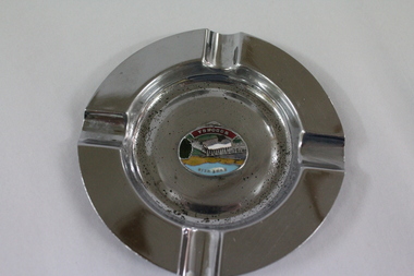
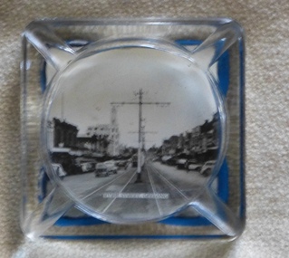
Memorabilia - Souvenir Ashtray Hume Weir Wodonga
Metal, china and glass ashtrays and other small pieces carrying scenic views of holiday destinations were a popular kind of souvenir during much of the 20th century. The pictures on the souvenirs ranged across natural beauty spots (beaches, waterfalls, rivers), civic buildings and monuments (town halls, war memorials), and indicators of local progress (commercial centres and occasionally even industrial sites).This ashtray is representative of a range of souvenirs used in the 20th century to depict Wodonga, Victoria and also on a State and National level throughout Australia.A metal circular ashtray including a coloured enamel image of the Hume Weir in the cenre."Above the central image "HUME WEIR" Beneath the central image "WODONGA"souvenir, hume weir, wodonga, ashtray -
 Wodonga & District Historical Society Inc
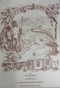
Book - A History of the Kiewa Valley, Esther Temple et al, 1989
This book briefly covers the period from the indigenous tribes who lived in the valley well before English settlers arrived. It documents the transformation of the area from a pristine valley environment to one that has been gradually over 200 years to a more commercial rural/industrial landscaped valley. The book details the first pioneers and their descendants, along with the changes to their environment.This book briefly covers the period from the indigenous tribes who lived in the valley well before English settlers arrived. It documents the transformation of the area from a pristine valley environment to one that has been gradually over 200 years to a more commercial rural/industrial landscaped valley. The book details the first pioneers and their descendants, along with the changes to their environment.kiewa river valley, pioneers victoria, kiewa valley social life and cusstoms -
 City of Kingston
Photograph - Colour, c. 1982
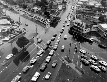
This aerial photograph of South Road and Nepean Highway, Moorabbin shows the area where houses and shops on the south side of the Nepean Highway have demolished for the widening of the highway. The pressures of rapid urban development in Moorabbin and beyond, especially to the south of Moorabbin caused bottlenecks and delays, especially at the South Road and Nepean Highway intersection, hence the scheme to widen Nepean Highway.The pressures of rapid urban development in terms of people, housing construction, industrial development and commercial activity, in Moorabbin and beyond, especially to the south would put pressure on road infrastructure in the region. In the early 1980s, a major road expansion of the Nepean Highway was implemented to increase capacity on this major thoroughfare for vehicle commuters. Car use had also increased with commuters from the increasingly populous southern suburbs travelling to their place of work in the Melbourne CBD.Colour photograph of an aerial view of South Road and Nepean Highway, Moorabbin. The image shows houses on the south side of the Nepean Highway that have demolished for widening of road. It features housing and commercial buildings looking north towards Cummins Road.Handwritten blue ink: 82 - 5452 - 11 Handwritten red ink: 112% Handwritten black ink: Ch. 7nepean highway, south road, moorabbin, roads, transport, infrastructure -
 City of Kingston
Photograph - Black and white, c. 1950
The image shows a line of traffic travelling along South Road in response to traffic light signlas while an increasing number of cars are banking up along Nepean Highway, also in response to traffic light signals.This image provides a strong contrast to images from earlier eras of the same intersection. The amount of traffic has increased enormously as well as commercial development.Black and white photograph with an aerial view of the intersection of Nepean Highway and South Road, taken from above the Moorabbin Council Chambers.Handwritten in black ink Pic [indecipherable] / 1000 Handwritten in red ink: 150%moorabbin, traffic lights, cars, nepean highway -
 City of Kingston
Photograph - Black and white, 5 January 1984
Moorabbin, Cheltenham and Highett are suburbs in the City of Kingston with a diverse mix of development and zoning. The market gardens, farms and paddocks have gradually been sub-divided into housing and industrial estates and associated infrastructure such as schools and shopping facilities. The area includes many parks, reserves and golf courses.This aerial image covers a diverse section of the City of Kingston, taking in the suburbs of Cheltenham, Moorabbin, Beaumaris and Highett. By 1984, the market gardens of the district have been replaced by housing and factories. The Gas and Fuel state-of-the-art Scientific Services Department is visible on Nepean Highway Highett. The CSIRO Highett site can also be seen. Both sites have now been demolished and have undergone remediation. The Southland site is visible and yet to be redeveloped by Westfield. This image portrays the diversity of development in the City of Kingston with a mixture of green spaces, housing and commercial and industrial features.Aerial photograph of Cheltenham, Beaumaris, Moorabbin and Highett within the City of Kingston. The area depicted in the 1984 aerial view includes Eden Street and Edward Street, Cheltenham (top left), Weatherall Road and Reserve Road, Cheltenham/Beaumaris (top right), Turner Road and Chesterville Road, Moorabbin (bottom left), Nepean Highway (left section), Graham Road and Middleton Street, Highett (bottom right). A large section of this image includes Cheltenham Park and Victoria Golf Club.White text: 3831-219 Lens information [indecipherable] RINGWOOD M/S 7922-3 RUN 15 Clockface image 5,300' ASL VIC DLS© 5-1-84cheltenham, highett, industrialisation, urbanisation, moorabbin, beaumaris -
City of Kingston
Photograph - Black and white, 3 March 1954
Cheltenham and Moorabbin are suburbs within the City of Kingston that were originally established as rural market gardening communities The area is bordered by Highett and Mentone. The market gardens, farms and paddocks have gradually been sub-divided into housing and industrial estates. Highett is developed with residential homes but was also the site of major facilities such as the Highett Gas Works. This aerial image covers a diverse section of the City of Kingston, taking in the suburbs of Moorabbin, Cheltenham, Highett and Mentone Residential housing development is prominent along the Frankston Railway line and the area still retains extensive market gardens and paddocks yet to be converted to a large industrial and commercial zone.Aerial photograph of Mentone, Cheltenham and Moorabbin within the City of Kingston. The area depicted in this 1954 aerial view includes Warrigal Road and Centre Dandenong Road intersection (top left); Charman Road, Patty Street, Bourke Street, Collins Street Mentone (top right); Keys Road Moorabbin (bottom left); Bay Road, Cheltenham (bottom right), Friendship Square, Cheltenham Park, Victoria Golf Club and Jack Barker Oval are visible. Nepean Highway and the Frankston railway line run centrally through the image. Highett Gasworks is also evident.White handwriting and type [indecipherable]. White image of clockface White image of compass White type 42956 Black handwriting 3/3/54 Williams [indecipherable] Black pencil: S [arrow] Black ink: 3/3/1954cheltenham, moorabbin, mentone, highett, market gardens -
 City of Kingston
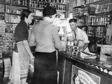
Photograph - Black and white, c.1930
This photograph shows Judd's Grocery Shop located at 224 Charman Road, Cheltenham in the 1930's. Alan Hutchins is the shop attendant, serving two patrons; Merle Judd (left) and Marion Elliott (right). Judd's Grocery Shop was opened by Clarence Judd in the 1920's and was a successor to the family's business formerly located on the corner of Centre and East Boundary Roads, East Bentleigh. Cheltenham had become an established village during the 1920's and Charman Road represented a second, more commercial development in the area. Black and white photograph of a grocery shop interior displaying a variety of items for sale. A male stands behind a counter, looking at the camera. Two females stand in front of the counter facing the male. One female is wearing a hat. Handwritten in blue ink: 181 Handwritten in red ink: 72%shopping, strip shopping, cheltenham, charman rd, grocery -
City of Kingston
Photograph - Black and white, 20 December 1945
This photograph depicts a section of Cheltenham with a mix of housing and market gardens. The visible market gardens, farms and paddocks have gradually been sub-divided into housing, commercial and industrial estates. A large part of Cheltenham was originally established as a rural market gardening community. The railway line and station brought urban development to the area and the gradual subdivision of farmland and large land holdings for the development of housing. Aerial photograph dated 1945 of the Cheltenham area in the City of Kingston. Sydney Street (bottom left); Sinclair Street (top left); Weymar Street area off Wilson Street, Charles Street (botton right).White print VIC-170; 57197; RUN5; PROJ.No.5; MELB.METROP AREA Lens information [indecipherable] Small photograph: clockface Black ink: 57197cheltenham, market gardens, urbanisation -
City of Kingston
Photograph - Black and white, 20 December 1945
This aerial image covers a section of Cheltenham, with a large paddock yet to be converted to an industrial and later a commercial zone.This aerial photograph provides evidence of the changing landscape of Cheltenham and Highett since WWII. Photographed in 1945, the image features a large block of land now the site of site the major transformation of Cheltenham with the development of the Southland shopping centre in the 1960s and expansion in the 1990s.Aerial photograph of the Cheltenham area in the City of Kingston. This 1945 image is concentrated on the area between Bay Road and Garfield Lane with the distinctive bend into Jean Street. A large block of land runs between the Nepean Highway and the rail line. This is now the area occupied by the extension of Southland in the 1990s.cheltenham, southland, aerial photograph, highett -
City of Kingston
Photograph - Black and white, 20 December 1945
This aerial image covers a section of Cheltenham, with a large paddock yet to be converted to an industrial and later a commercial zone.This aerial photograph provides evidence of the changing landscape of Cheltenham and Highett since WWII. Photographed in 1945, the image features a large block of land now the site of site the major transformation of Cheltenham with the development of the Southland shopping centre in the 1960s and expansion in the 1990s.Aerial photograph of the Cheltenham area in the City of Kingston. This 1945 image is concentrated on the area between Bay Road and Garfield Lane with the distinctive bend into Jean Street. A large block of land runs between the Nepean Highway and the rail line. This is now the area occupied by the extension of Southland in the 1990s. It is a negative version of VKHC124.cheltenham, southland, market garden -
 City of Kingston
Photograph - Black and white, c.1960
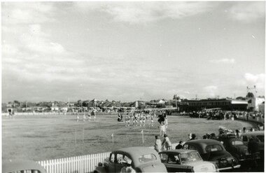
This photograph shows the Linton Street oval in Moorabbin in the early 1960's before it was redeveloped to become the home ground and club headquarters of the St Kilda Football ClubThe arrival of the St Kilda Football Club to Moorabbin was a significant event in the social and commercial development of Moorabbin. The presence of a VFL football team in the community created a sense of identity and belonging for many. Black and white photograph of a sporting oval. There are people on the field and more people lining the outside edge of the field. A row of parked cars is visible across the foreground.Handwritten in red ink: 60%city of moorabbin, moorabbin, st kilda football club, linton street oval -
 City of Kingston
Photograph - Black and white, c. 1920
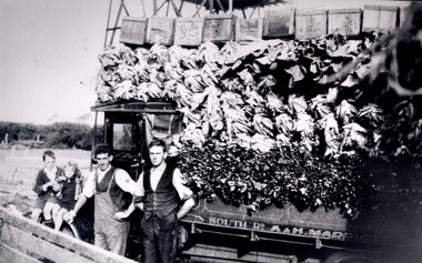
Market gardening was an integral part of the development of the area now known as Kingston. In this image there are two men standing beside a truck loaded with vegetables. Painted on the truck are the words South Rd, A & H Marriott, indicating these men are from the Marriott family. The truck appears to be a Republic Commercial Car by Republic Motor Truck Co, Michigan, c. 1916.The Marriott family arrived in Port Phillip in 1857. It wasn't until 1876 that the family purchased 30 acres with a four-roomed house in East Boundary Road, in the area then called East Brighton.Black and white image of two men standing in front of a truck fully loaded with vegetables intended for market. There are also two children standing in front of the truck.Handwritten in black ink on a round red sticker on the reverse: X18 Handwritten in red ink on reverse: 35% -
 Melbourne Tram Museum
Domestic object - Ashtray, 1950s
Glass ashtray, with photo of Ryrie St Geelong, centre poles, tram in distance adhered to the rear of the object with a blue plastic backing. Tray has positions for four cigarettes. Image taken from an unknown commercial postcard - see Ballarat Tramway Museum, Reg Item 4204.trams, tramways, souvenirs, geelong, ryrie st -
 Melbourne Tram Museum
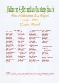
Document - Framed Document, Kevin Staines, "Port Melbourne Bus Depot - 1937 - 1966 Honor Board", Mar. 2016
Framed presentation of the "Port Melbourne Bus Depot - 1937 - 1966 Honor Board", listing the bus drivers, conductors and conductresses whose name appeared on the Yard Sheet on the last day of the depot - 30/6/1966. It opened on 9/12/1937. Includes some of the known Officers and one of the revenue clerks. Prepared by Kevin Stanes 2016. Framed with a commercial black plastic frame with a light wood back, glass sheet and various clips and suspension points. Listing of names and other information provided by Kevin Stanes by email: Port Melbourne list - see htd1443 - Port Melbourne Bus Depot Employees List.doc in the documents file. For email and recollections in particular about Doncaster - see htd1443email.pdftrams, tramways, port melbourne, buses, drivers, conductors, officers, depots -
 Melbourne Tram Museum
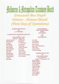
Document - Framed Document, Kevin Staines, "Doncaster Bus Depot - Drivers Honour Board - (First Day of Operations), Mar. 2016
Framed presentation of the first bus drivers at Donacaster and the companies they worked for prior to working at Doncaster. Prepared by Kevin Stanes 2016. Framed with a commercial black plastic frame with a light wood back, glass sheet and various clips and suspension points. Listing of names and other information provided by Kevin Stanes by email: Doncaster list - see htd1444 - Doncaster Bus Depot Employees [First Day] For email and recollections in particular about Doncaster - see htd1443email.pdftrams, tramways, doncaster, private bus companies, buses, drivers, conductors, officers, depots -
 Melbourne Tram Museum
Administrative record - Contract bid documents, Commonwealth Engineering (Comeng), "Comeng – submission bid – to build artic trams (Contract 4000) – March 1984.", Mar. 1984
Large set of photocopied documents - titled "Comeng – submission bid – to build artic trams (Contract 4000) – March 1984" - B class trams .1 - Book 1 - Commercial submission - tender response, commercial payment, schedules. .2 - Book 2 - Technical submissions, equipment from AEG, GEC, ACEC, Brush, Mitsubishi, Ganz Electric, Holec, Itoh/Garrett/Hitachi and Stromberg, drawings, and alternatives, options. Also looks at the financial aspects. Documents not in order but marked what they are. All documents stored in a single box - taped together. Dated March 1984. Has a table of contents.trams, tramways, mta, the met, b class, tenders, specification, comeng, commonwealth engineering -
 Melbourne Tram Museum
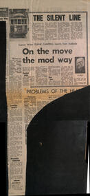
Newspaper, Herald Sun, "The Silent Line", 18-8-1969
Reports on a Science Congress in Adelaide and a speech by Robert Risson about future transport possible systems - all types such as conveyor belts, air cushion vehicles, magnetic cushions, pneumatic tubes, moving footpaths, jet-propelled vehicles, gas turbine and diesel electric buses. These are known as "gadgetbahns" mooted proposals that seldom come to commercial fruition. His main emphasis was on the future all-electric tram fleet that was proposed for Melbourne. Also notes underground systems such as San Francisco. Item by Science Writer Frank Campbell.Yields information about possible future transport systems - gadgetbahnsNewspaper clipping - "The Silent line" and "On the move the mod way" - The Herald "18-8-1969" tramways, trams, melbourne, public transport, future transport, transport systems, electric trams, all-electric trams, robert risson, gadgetbahns, underground tramways -
 Melbourne Tram Museum
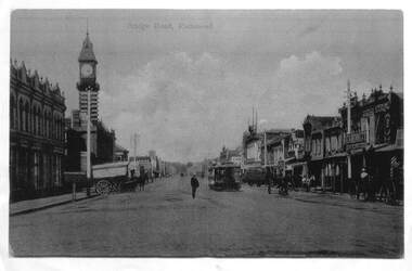
Photograph - Enlargement of a postcard, Bridge Road Richmond, c1900
The first image shows the shops on either side of Bridge Road with horse drawn carts and one cable tram. The second image from the Town Hall tower, shows two cable tram sets, the narrowing of the road. Has in the view Guddon & Selleck Auction House and Property Exchange also advertising Commercial Union Assurance Co. and George Stirling and Sons store.Yields information about Bridge Road, c1900Set of two A3 enlargements of postcards 1 - Looking east along Bridge Road from near Church St 2 - Bridge Road Richmond - from Town Hall looking westcable trams, tramways, richmond, bridge road, -
 Melbourne Tram Museum
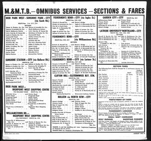
Poster, Melbourne & Metropolitan Tramways Board (MMTB), "M&MTB - Omnibus Services - Sections & Fares", Aug. 1975
Poster, paper mounted or glued to cardboard sheet for use in tramcars - titled "M&MTB - Omnibus Services - Sections & Fares"" giving details of fares for each section, location of sections for all routes. Notes prepayment of fares, children fares, passengers luggage including baby carriages, golf buggies and shopping pushers. Dated August 1975. Printed by Standard Commercial Printers, Cheltenham. Two copies held. Both copies have colour pencil drawings on the rear - one of a Polar bear and the other of a Martini Porsche racing car.trams, tramways, fares, mmtb, posters, routes, buses -
 Melbourne Tram Museum
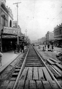
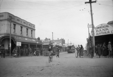
Photograph - Digital Image, Sydney Road, Coburg, looking south from near Bell St, c1920
Digital Image of Sydney Road, Coburg, looking south from near Bell St, showing the track repair work to remove bricks from the rails that were resulting in damage to the track foundations by letting water into the track. Photo supplied for identification purposes May 2020, by the Editor, Australian Railway History - see htd4680doc for email correspondence. Image belongs to the ARHS NSW Div. Rail Resource Centre No. 117413 Was used in the June 2020 issue of Australian Railway History - see Reg Item 4684. In the background are the Commercial Bank of Australia, A. M. Hadden Chemis, Walkers Stores, Joblings boots, a Lending Library with adverts for The Age, The Argus, The Herald.trams, tramways, sydney road, coburg, track repairs, trackwork -
 Melbourne Tram Museum
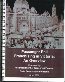
Document - Report, Department of Treasury and Finance, "Passenger Rail Franchising in Victoria an Overview", Apr. 2000
Report - 170 pages approx., spiral wire bound, plastic front cover, card back cover with a c1925 photograph of Flinders St Station on the front cover, titled "Passenger Rail Franchising in Victoria an Overview", prepared by the Department of Treasury and Finance for the State Government, April 2000. Has a table of contents. Provides an introduction into the public transport system, reform, auditor general's recommendations, policy framework regarding privatisations and franchising, commercial issues and processes, employment restructuring, legal framework, outcomes, investments, costs, leases, risk transfer. Has annexures on payments to franchisees, rolling stock leases and final bid template.trams, tramways, public transport, franchising, ptc, privatisation, passengers, minister for transport -
 Melbourne Tram Museum
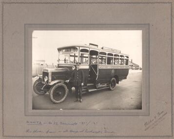
Photograph - Black and White photograph/s - mounted, Fletcher & Frue, Commercial Photographers, mid 1920's
Photograph, Black and White, mounted onto a grey card with edge linings, MMTB bus No. 37, Thornycroft, model "BT". Has the well dressed uniformed driver standing alongside the front wheel. Has destination of Lonsdale St and side destination of "Melbourne St Kilda Road" Has Registration number of "689-7". Photographers stamp in bottom right hand corner, "Fletcher & Frue, Commercial Photographers, Luna Park St Kilda"In ink under the photograph "MMTB bus No. 37, Thornycroft, model "BT". This photo from Mr. George A Rushmeyer, Driver" On the rear is Keith Kings stamp, photo number "S-A 1111'trams, tramways, buses, thornycroft, uniforms, st kilda, bus replacement, conversion, tram 37 -
 Melbourne Tram Museum
Film - Compact Diskette with video, Fletcher Films, "Generations Why Trams?", Aug.. 2007
Compact Diskette - CD - plastic contained with in part clear, part black plastic case, titled "Generations Why Trams?" showing the preparation of two television commercials August 2007 and the final production. Has the Love Your Trams logo. Features a number of school children and Football and media celebrates. Film by Fletcher Films, Flash Advertising the Producers. Mini CD/DVD copied onto the AV file database.On rear in ink "East front / west is back"trams, tramways, yarra trams, compact disc cd, television celebrity, advertising -
 Melbourne Tram Museum
Negative, Ellis Collection, c1956
Negative (120) of the intersection of Moreland Road and Sydney Road, Brunswick, during the 1920's. In the view is a cable tram set shunting. A tramway employee and two boys at the front of the grip car seem to be manipulating something. Saloon car is No. 183 with the conductor pushing the car. The grip car has the destination of Brunswick and the saloon Flinders St? Note the two steel tramway poles and overhead for the North Coburg electric tram service from Moreland Rod into Sydney Road. In the background is the Moreland Hotel, Clarkson chemist and the Commercial Bank of Australia. An low resolution A4 laminated was received with the negatives. Hi Res image filed in the dbtext/hawthtramcoll/Large Images/htd3589large.jpgtrams, tramways, brunswick, cable trams, sydney rd, moreland rd, tram 183