Showing 1372 items matching "east side"
-
 Melbourne Tram Museum
Slide - Set of 2, John Webster, 21/07/1959 12:00:00 AM
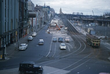
Set of two Colour slides, Kodak, white cardboard of trams of the construction of the Flinders St overpass over King St from the railway viaduct over Spencer St, looking east. Shows the temporary track on the south side of the bridge and the large car park under construction from the former cool stores on this site. Also shows the former track into Spencer St. Note the cross over at the base of the bridge. .1 - possibly 357 running a route 27 to Spencer St. Has the Great Southern Hotel on the left side. .2 - similar photo taken from the viaduct, further along - has the Bushels and Penfolds Wines signs in the background.Hand writing on rear in ink; .1 and .2 - "2-4-60 - Tracks - Flinders St Melbourne" Both slides have the speed and the f reading on the left hand side.trams, tramways, trackwork, flinders st, king st, track construction, bridges, w2 class, route 27, tram 357? -
 Melbourne Tram Museum
Photograph - Black and White photograph, early 1940
Black and white photograph white a grey and green border of possibly tram W2 class 219, southbound in St Kilda Road with one parked car on the left hand side. Shows the nature of St Kilda Road during the winter. Photo during the early 1940's with the tram having white stripes for war time. The tram has the destination of East Brighton, Route 64.trams, tramways, st kilda rd, route 64, east brighton, tram 219 ?, w2 class, world war 2 -
 Melbourne Tram Museum
Negative, Wal Jack, 1/09/1941 12:00:00 AM
Black and white negative, by Wal Jack, of W5 801 turning from Lygon St into Holmes Road via Albion St, East Brunswick. The tram has the destination of East Coburg. The tram is fitted with a head light mask. There appears to be a solider on the tram, along with a trammies in uniform cap sitting down in the drop centre. The conductor could be on the other side of the tram. In the background is a tram stop shelter, a wall advert for the Liberty Theatre, a fire alarm pillar and a drinking fountain. Photo dated 1-9-1941 in the Wal Jack album.trams, tramways, east coburg, albion st, holmes st, headlight mask, shelters, tram 801, w5 class, world war 2, mmtb -
 Melbourne Tram Museum
Negative, Wal Jack, 25/06/1955 12:00:00 AM
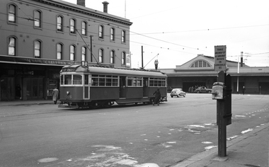
Black and white negative, by Wal Jack, of W6 985 east bound in Bourke St at Exhibition St with the Eastern Market in the background. There is one maybe two men in the cab on either side of the driver. Could be driver training at the time of the opening of the line 25-6-1955 The tram itself would be very new as well.trams, tramways, bourke st, training, new tramway, w6 class, tram 985 -
 Melbourne Tram Museum
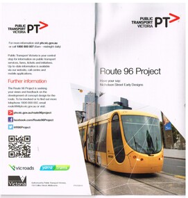
Pamphlet, Public Transport Victoria (PTV), "Route 96 Project - Have your say: Nicholson Street Early Designs", 2013
Set of two pamphlets involved the concept of the "Route 96 Project - Have your say: Nicholson Street Early Designs". Notes the introduction of the E class tram. .1 - DL full colour booklet, 24 pages with a questionnaire response form, outlining the Route 96 project to speed up trams providing route segregation for most of the distance. Issued 2013. Provides concept designs, Blyth St terminus, easy access stops, tram lanes. Gives dates for meetings. .2 - fold out full colour map, 8 folds, printed both sides providing details of the planning for the various stops and segregation between Victoria Parade and Blyth St.. The loss of car parking and issues with the Fitzroy St St Kilda stop met a lot of opposition. The Blyth St terminus was rebuilt June 1015. Two copies held., both were originally contained within a plastic wrapper. One wrapped version obtained when collected. Produced by Public Transport Victoria. See also Reg Item 24?? for a 2009 version.trams, tramways, yarra trams, route 96, east brunswick, e class, superstops -
 Melbourne Tram Museum
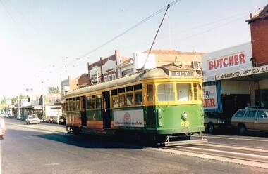
Photograph - Colour Print, c1985
Colour print of SW5 818 at the East Malvern Darling Road Terminus, c1985, with destination of City and showing route 3. VicSig.net (accessed 8-11-15) notes that the tram, built as a W5 was converted to a sliding door car in Oct. 1984. In the background is a Butcher shop and Windeyer Art Gallery. Advert on side of tram is an expired parking meter - something you don't see on The Met.trams, tramways, east malvern, darling rd, sw5 class, route 3, tram 818 -
 Melbourne Tram Museum
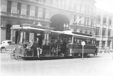
Photograph, Cable tram 534 in Bourke Street outside the St. James Building, 1924
The photograph shows a cable tram set with trailer No. 534 east bound in Bourke St on its way to Nicholson St passing the St. James Building at William Street. The conductor standing at the back of the grip car is in MMTB uniform with his ticket wallet in his left hand and bag visible. The grip man appears to be ringing his bell. There is a side advertisement for the "All Australian Exhibition". A reference to the exhibition is in The Argus of 3/11/1924 - see reference.Yields information cable trams in Bourke St and their crews.Photograph, black and white, plain backtrams, tramways, cable tram, bourke st, conductors, tram crews, william st, tram 534 -
 Melbourne Tram Museum
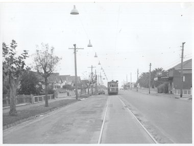
Photograph - Overhead Track lighting Nicholson St Coburg, Melbourne & Metropolitan Tramways Board (MMTB), 1960
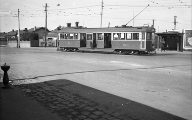
Photo shows extensive track lights on the left side of the single-track Nicholson St East Coburg tram line with W2 class tram 473? inbound on route 1 just to the north of Grant St. This section of track was considered dangerous and to alleviate the problem of inbound or southbound tramcars not being visible well in advance to northbound motorists, the MMTB installed the track lights. The Chief Engineer at the 24/3/1960 meeting of the Board advised of the scheme that the track lights would be progressively switched on in advance of a southbound tram. The line was eventually duplicated in Dec. 1966.Yields information about a track lighting system to improve safety on a single line of tramway in East Coburg.Black and white photo, plain backnicholson st, single line, track lights, east coburg -
 Melbourne Tram Museum
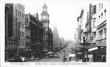
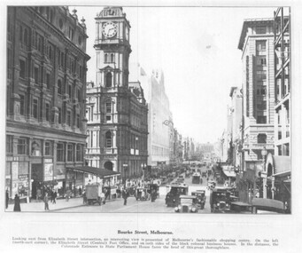
Postcard, Rose Stereograph Co, "Bourke Street looking to Parliament House, Melbourne", late 1940s
Rose Series postcard No. P 3497, titled "Bourke Street looking to Parliament House, Melbourne". Photo looking east from near Queen Street with one double decker bus at the Elizabeth Street stop with other buses in the distance. Two trams can be seen in Elizabeth Street on either side of Bourke Street. A horse drawn cart can be seen climbing the hill. On the northside of the Bourke Street can be seen, Warburton Franki & Co, Electrical Engineers; Coles & Garrard, Optometrist; General Post Office (GPO); Myer; Buckley and Nunn and Foy's department stores. Yields information about Bourke Street mid to late 1940s.Postcard - printed real photograph with Rose Stereograph Co. name on the rear.tramways, trams, bourke st, buses, elizabeth st, mmtb buses, leyland, td5c class -
 Melbourne Tram Museum
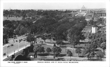
Postcard, Rose Stereograph Co, "Princes Bridge and St Kilda Road Melbourne", late 1930s
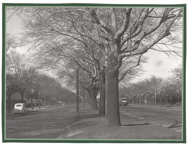
Rose Series postcard No. P 10649, titled "Princes Bridge and St Kilda Road Melbourne", looking south from Flinders St station clock tower showing Princess Bridge and St. Kilda Road with a W2 class tram in the view at the intersection of City Road to the west and Alexandra Avenue to the east. In the background is the Shrine of Remembrance. To the west of St. Kilda Road running in parallel from City Road to Mafra Street is Sloss Street, it was removed in the late 1960' for the construction of the National Arts Center. The former "Green Mill" dance hall built in 1926 become the "Forty Club" in 1933 and evolved to being the "Trocadero Palais" by the late 1930's can be seen on the right of the photo. The road on the south side of the Yarra River, at the bottom of the photo, is Riverside Avenue. Yields information about St Kilda Road, late 1930s.Postcard - printed real photograph with Rose Stereograph Co. name on the rear.trams, shrine of remembrance, st kilda road, princes bridge, w2 class, tramways -
 Melbourne Tram Museum
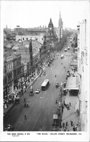
Postcard, Rose Stereograph Co, "'The Block' - Collins Melbourne ", c1910
Rose Series postcard No. P 955, titled "'The Block' - Collins Melbourne " looking east from Elizabeth Street. Has at least nine cable trams in the view, along with horse drawn vehicles and motor cars. Has signs for James Thelwell ladies Tailor and Lafayette. The verandah on the south side of Collins Street is part of the "Centreway Arcade" and building constructed in 1911-12.Yields information about Collins St, c1914.Postcard - printed real photograph with Rose Stereograph Co. name on the rear.Has the Ken Magor stamp on the rear.trams, tramways, cable trams, collins st, melbourne town hall -
 Melbourne Tram Museum
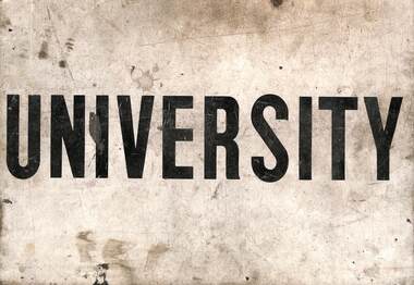
Sign, The Met, "East Malvern / University", c1980?
Sign - plastic sheet with "University" and "East Malvern" printed on opposite sides. Possibly used for bus replacement services - about the same size as a sign used for this purpose - see Reg Item 6048. Not known when used.trams, tramways, destination indicators, east malvern, university, auxiliary board, buses -
 Melbourne Tram Museum
Negative, Wal Jack, 1955-56
Black and white negative, by Wal Jack, of W7 1006 at the Spencer St terminus for the then new tramway to East Preston, route 90. The Conductress has changed the rear pole and is walking towards Spencer St. In the background is Spencer St Station and Carlyon's Hotel. On the post on the right hand side of the image is a Bundy clock, a track telephone and a sign "Take Nicholn (Nicholson) St and E. Brunswick (Brunswick) buses in Lonsdale St" There is a sign on the hotel advertising the Prince Henry's Hospital appeal. Photo not in Wal Jack Melbourne album.trams, tramways, bourke st, w7 class, new tramway, buses, bundy clock, route 90, tram 1006 -
 Melbourne Tram Museum
Negative, Wal Jack, c1960
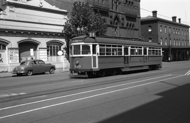
Black and white negative, by Wal Jack, of W6 988 arriving at the terminus in Bourke St. Tram showing the destination of East Brunswick route 96. c1960? The tram has been prepared for side advertisements. In the background is 667 Bourke St - Parkway Motors, the MTOCo office building (MMTB) and Carlyon's Hotel, Photo not in Wal Jack Melbourne album.trams, tramways, bourke st, route 96, head office, w6 class, east brunswick, tram 988 -
 Melbourne Tram Museum
Photograph - set of 3 Black and White photographs, Tramway Museum Society of Victoria (TMSV), c1975
Series of three Black & White Photographs of a postcards made by the TMSV Sales of: .1 - Bourke St, looking east with the GPO in Elizabeth St in the view, along with many vehicular traffic - has the Myer building. c1920? .2 - Bourke St looking west from Swanston St prior to the construction of the Myer building. c1910. Has a number of horse drawn vehicles in the view and one motor car. Coles Book arcade on the south side. .3 - Similar to .1, but c1910 - has L Cohen & Co, Tailors and Outfitters. in the view. All views have cable trams in the view.trams, tramways, bourke st, elizabeth st, gpo, cable trams -
 Ringwood and District Historical Society
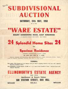
Flyer, Subdivisional Auction Sale Brochure, Ware Estate, East Ringwood, Vic. - 1958
Folded double-sided advertisement for auction of 24 home sites and existing residence on Saturday, 24th May, 1958, including locality map, subdivision layout, terms of sale, and summary of local facilities and services. Additional plan of lots 28-33 dated 26/10/60 by Licensed Surveyor for Kirkpatrick & Webber, 225 Maroondah Highway Ringwood headed Plan of Subdivision of part of Crown Allotment 26A Parish of Ringwood.Subdivision includes Mount Dandenong Road, Ware Crescent, Davey Drive, and Grey Road (later Grey Street). Timber residence included in the subdivision was formerly Ware Kindergarten Holiday Home. (Agent) Ellingworth's Estate Agency, 580 Station Street, Box Hill - (Phone) WX1228. -
 Ringwood and District Historical Society
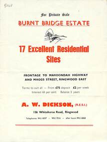
Flyer, Land Sale Brochure, Burnt Bridge Estate, Ringwood East/Croydon, Vic. - circa 1959
Bi-folded single sheet with black and red print both sides including subdivision features and local facilitiesSubdivision layout includes Marcus Road, Maggs Street and Maroondah Highway Croydon/Ringwood East. (Agent) A.W. Dickson, 136 Whitehorse Road, Ringwood, Telephones WU 6007, WU 7016, after hours WU 6868. -
 Ringwood and District Historical Society
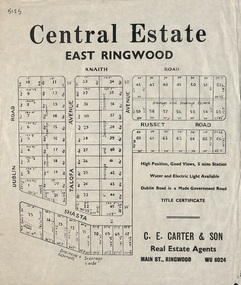
Flyer, Land Sale Advertisement, Central Estate, East Ringwood - 1948
East Ringwood Central Estate auction sale of allotments previously advertised for Saturday October 23rd (1948). Victorian Collections reference 5138 refers.Single sided leafletSubdivision includes Dublin Road, Knaith Road, Talofa Avenue, Russet Road, and Shasta Avenue. Agent - C.E. Carter & Son, Main Street, Ringwood. WU 6024. -
 Greensborough Historical Society
Leaflet, Road changes: Greensborough and Watsonia March 2019, 2019_03
Outline of proposed changes to the plan for roads around the Old Greensborough Road and Watsonia Station areas1 p. leaflet printed in colour both sides north east link, watsonia station, old greensborough road watsonia -
 Bacchus Marsh & District Historical Society
Photograph, Main Street Bacchus Marsh 1883 looking east
View of Main Street Bacchus Marsh 1883, showing early notable buildings on the southern side of the street, including the Courthouse, National Bank of Australasia, Border Inn, Hall of Commerce building. Small sepia unframed photograph on card with gold border framing photograph. Housed in the album, 'Photographs of Bacchus Marsh and District in 1883 by Stevenson and McNicoll'. Several horse-drawn vehicles can be seen travelling along an unmade road. Piles of excavated dirt can be seen along the side of the road. Four substantial two-storeyed buildings can be seen along the southern side of the street.On the front: Stevenson & McNicoll. Photo. 108 Elizabeth St. Melbourne. COPIES CAN BE OBTAINED AT ANY TIME. On the back: LIGHT & TRUTH inscribed on a banner surmounted by a representation of the rising sun. Copies of this Portrait can be had at any time by sending the Name and Post Office Money Order or Stamps for the amount of order to STEVENSON & McNICOLL LATE BENSON & STEVENSON, Photographers. 108 Elizabeth Street, MELBOURNE. stevenson and mcnicoll 1883 photographs of bacchus marsh and district, bacchus marsh roads and streets, bacchus marsh main street 19th century -
 Old Gippstown
Building - School
2903 SUNNY CREEK formerly YARRAGON EAST. Sunny Creek State School, first called Yarragon East, was situated on Sunny Creek Road between Yarragon and Trafalgar and was opened in 1888. It was generally served by two teachers or a Head Teacher assisted by a Sewing Mistress. Edwin Mann taught there for 35 years, with his wife, Mrs Mann, as the Sewing Mistress for some years. [Extracted from Vision and Realisation: A Centenary History of State Education in Victoria, Vol. 3, 1973. This does not contain any details of the actual construction of the school, which is a typical Education Department building, and may date from later than 1888]High local historic significance, with some social significance: reunions of old students still held. (Dr Linda Young, Deakin University, significance assessment July 2009)Single-classroom State School. It is a rectangular-shaped timber building with weatherboard walls, timber frame and corrugated iron roof. An outside verandah is situated along the side of the building. Inside there is a small entry porch, a blackboard the length of the room (with fireplace) and a small store-room/cloak room. Built in 1888Has a name board above the front window that reads " SUNNY CREEK SCHOOL SS2903".school, sunny creek, old gippstown, west gippsland, gippsland, gippsland heritage park, goldfields, coal mines, victorian era, moe, historical village, education, sunny creek road, baw baw shire, yarragon east, latrobe valley, old gippsland heritage park, latrobe city council, board of education -
 Melbourne Tram Museum
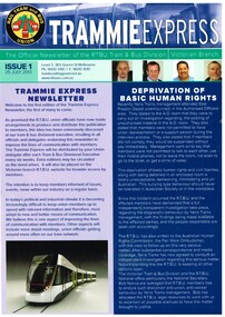
Pamphlet, Yarra Trams, "Trammie Express - Issue 1 - 25/7/2013", Jul. 2013
Full colour A4 double sided sheet, titled "Trammie Express - Issue 1 - 25/7/2013", issued by the RTBU as an occasional newsletter - not known if further issues. Main item is "Depravation of Basic Human Rights", looking at an incident between Yarra Trams Management and workers at East Preston Depot. Also has items on Insulated Tram Incidents and RTBU Holiday Units.trams, tramways, rtbu, yarra trams, east preston, unions -
 Melbourne Tram Museum
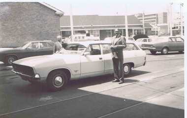
Photograph - Black & White Photograph/s, late 1970's or early 1980's
Black and white photograph of Fred Turner and Howard Smith (Workshop Manager) at East Preston Depot late 1970's or early 1980's, standing on either side of a Ford Station Wagon.trams, tramways, east preston, personnel, tram 23 -
 Melbourne Tram Museum
Map, Melbourne & Metropolitan Tramways Board (MMTB), MMTB Route Maps, 1979
Series of colour maps for various tram and bus routes, dated 1979. Also contained, not scanned are letters, reports, and specifications for printing these maps for use in shelters etc. Some have the Transport Information Centre telephone printed on them. Some are finished with a plastic laminate finish on either one or both sides. Show the major cross streets, parks, schools, other tram routes, major stop numbers, and railway lines. See also item 3909 for another example of these. Trams 1 - City route guide - R9/77 - showing all route numbers and destinations that passed through the CBD. 2 - Bourke St tram routes - R4/77 - East Brunswick Blyth St and East Preston Tyler St and intermediate routes, routes 95, 96, 97, 90, 89 and 88. 3 - Malvern, East Malvern, Carnegie, and East Brighton Tram Routes (from St Kilda Junction) - R1/79 - shows routes 5, 3, 67, 66, 61, 62, and 64. 4 - Elizabeth St tram routes - R12/77 - Essendon Airport, West Maribyrnong, North Coburg lines, routes 50, 58, 60, 54, 57, 52. 49, 59, 18, 20 and 19 5 - Flinders St tram routes - R5/78 - North Balwyn, East Burwood, routes 48, 40, 41, Hartwell, 28, 74 and 75 6 - Kew - St Kilda Beach - R1/79 - Route 69. 7 - Mont - Albert City - R11/77, shows routes 43. 47. 45. 44 8 - St Kilda Rd Tram Routes R12/77 - details South Melbourne Beach, route 1 and route 2 and St Kilda Beach routes 15, 16, and 55 otherwise shows where the various routes branch off St Kilda Road 9 - Batman Ave tram routes - R9/77 - Wattle Park, North Richmond and Prahran - routes 70, 71, 78 and 79. 10 - Footscray - Moonee Ponds - R3/81 - Route 82 11 - Swanston St tram guide - R1/79 - lists all routes and route numbers that branch or cross Swanston St between Grattan St and St Kilda Junction. 12 - Toorak Camberwell and Glen Iris tram route with Camberwell Junction and Malvern Town Hall, R1/79, routes 8, 7, 6, 72, and 73 shown. 13 - West Preston - Beach tram routes - R12/77 - routes 10, 11, 9 and 12, 14 - William St tram routes - R12/77 - Route 55, 56, and 63 - South Melbourne Depot and Domain. Buses 1 - Footscray, Sunshine, Deer Park, Nth Altona & Fishermans Bend - R2/79 2 - Box Hill bus routes to Templestowe, Heidelberg & East Kew - R6/78 - notes superseded by R3/82 3 - Plan of Russell St Melbourne bus departure bays. 4 - Box Hill, Mitcham & Ringwood bus routes to East Doncaster & Warrandyte - R3/82 5 - City - Warrandyte & East Doncaster bus routes - R3/82 & R6/78 6 - Bulleen - City - Port Melbourne - Garden City Bus route - R6/78 7 - North Altona - City bus route - 11/78 8 - Clifton Hill - Elsternwick - R2/79 9 - La Trobe - Northland - West Heidelberg - City Bus Service via East Freeway - 11/79 and R3/81 10 - Box Hill, Mitcham & Ringwood Bus Routes to East Doncaster & Warrandyte - R10/84 - with the Metropolitan Transit logo.Yields information about tram and bus routes in late 1970s early 1980s.Book - brown comb binding, card and clear plastic covers containing both bound and unbound maps and documents.K C Painter on front cover in ink.tramways, mmtb, tram routes, maps, bus routes, route numbers, routes, route guide -
 Melbourne Tram Museum
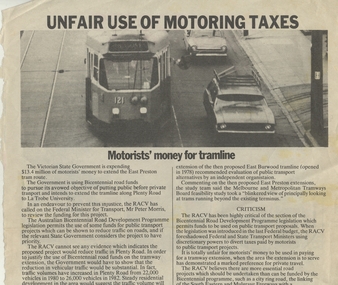
Newspaper, Royal Automobile club of Victoria (Rav), "Unfair Use of Motoring Taxes" and "Members have their Say", Aug. 1983
Two pages from the RACV Royal Auto magazine that concerned Melbourne's tramways, printed on off white paper with some colour. 60.1 - Article titled "Unfair use of Motoring Taxes" about the use of the "motorists" money for the extension the East Preston Tram route. The funds concerned came from the Bicentennial road funds. From the September 1983 issue. 60.2 - Members letters for and against Tram Priority, printed on either side of the sheet, page 17 and 18, from the August 1983? issue of Royal Auto, titled "Members have their Say". 13 letters either way.trams, tramways, racv, mmtb, east preston, fairways, tram priority -
 Melbourne Tram Museum
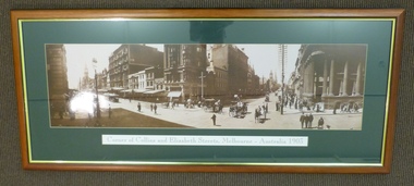
Print - Framed Print, Malvern Framing Gallery, "Corner of Collins and Elizabeth St, Melbourne, Australia 1903", 1997
Framed and glazed photograph of the corner of Collins and Elizabeth Streets Melbourne, looking North East. Wooden frame, brown and gold lining, green card cut to present photograph, with title ""Corner of Collins and Elizabeth St, Melbourne, Australia 1903". Has been lined with brown paper on rear. Two screwed frame hanging supports on either side with four runs of string between them. Has Post Office, Town Hall and Scots Church Towers in the view. One cable car set and one motorised car along with many horse drawn vehicles. Has signed buildings for: Falk Carter & Verner City Hotel M.A Alexander R.H. Alston Blitz's DentistOn rear in black felt pen "$N/XX" and "1997"trams, tramways, melbourne, collins st, cable trams, elizabeth st -
 Melbourne Tram Museum
Photograph - Digital Image, Kevin O'Reilly, "Kew Burke Rd' looking at the East Kew Tram terminus, c1925
Image from CD (Compact Diskette for use in computers) - see Reg Item 135. Image titled "Kew Burke Rd' on CD, of looking at the East Kew Tram terminus with the city skyline in the background, c1925. Photo published in the Bellcord No. 16, Oct. 2012. From the article with the photograph; The terminus was located at the intersection of High St, Burke, Kilby and Doncaster Roads. We are at the outer edges of Melbourne’s suburbia at the time, unlike the current tram terminus of today. Burke Road, north of Doncaster Road is clearly under construction in preparation for the new river crossing. The vacant block of land in the foreground will remain so for another ten years or so. In 1960 the new Dickens Supermarket was built on this site and the intersection became known locally as Dickens Corner. The narrow track on the left hand side of the photo is Doncaster Road. The tram at the terminus is a straight-sill single trucker of one of the G, K, Q or R classes. It is finished in the late MMTB chocolate and cream livery. A cable grip car body has been placed as a tram shelter at the terminus. The church was subsequently relocated to Francis Street Yarraville where it still stands today as a private residence. Behind the large hedge on the south side of High Street is Smith’s Dairy. Part of this land would be sold to the MMTB for a planned new tram depot Behind the large hedge on the south side of High Street is Smith’s Dairy. Part of this land would be sold to the MMTB for a planned new tram depot but by the early 1960s it was transferred to the Education Department for construction of the Kew High School. The last portion of the dairy closed in the 1970s.trams, tramways, kew, burke rd, east kew, doncaster rd -
 Melbourne Tram Museum
Photograph - Digital Image, Kevin O'Reilly, series of three images of the Hawthorn Bridge over the Yarra, c1930, c1930's
Image from CD (Compact Diskette for use in computers) - see Reg Item 135. A series of three images of the Hawthorn Bridge over the Yarra, c1930, during the era with problems with the bridge. See separate article for more details. Richmond 6, Richmond, Richmond 3 on the CD as original files. .1 - Looking from the south west, at the Hawthorn bridge with the temporary wooden bridge being constructed on the south side. Has the cable tram depot in the photo and part of the Burnley racing course. Temporary track on the north side of the steel bridge and crossings can be seen. .2 - Looking along Bridge Road to the east with Hawthorn Bridge in the middle of the photograph. Shows the industrial and residential areas, Hawthorn Railway Station and part of the Burnley Race course, the cable tram depot building. W class tram in Church St Hawthorn and W class tram crossing the bridge on the north side temporary track. Note the cable tram used as a shelter on the north east corner of the bridge. .3 - Looking south along River St towards Bridge Road, with the Yarra River and Hawthorn Bridge on the left side of the photograph. Shows the industry in the area at the time, wool and skin Merchants, north side of the cable depot, housing and the outlook to the river!trams, tramways, hawthorn, yarra river, burnley, richmond, hawthorn bridge -
 Melbourne Tram Museum
Poster, Minister of Transport, Transport in Victoria", late 1970's
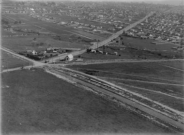
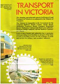
Full colour poster, single sided, printed on gloss white paper, titled Transport in Victoria", giving details of the functions and the various authorities and boards reporting to the Ministry of Transport. , Country Roads Board, Victorian Railways Board, Westgate Bridge Authority, Melbourne Tramways Board, Melbourne Underground Rail Loop Authority, Transport Regulation Board, Railway Construction Board Has photos of the various activities of the Boards, including an aerial photo of Melbourne CBD from the south east, showing the Flinders St rail yards. Photo of Z class tram, but number has been removed. Has the Ministry logo in the bottom right hand corner. See also Reg Item 1352 for a book of the same title.In ink in top left hand corner "4J40" - AETA Library location.trams, tramways, minister for transport, railways, trb, crb, murla -
 Melbourne Tram Museum
Photograph - Illustration/s, c1979
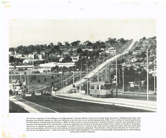
Illustration - black and white - possibly cut from a calendar sheet - of Burwood Highway, looking east just west of the Elgar Road intersection. Shows the relatively new track and Z25 inbound to Spencer St. Has a golden fleece service station on the left hand side. Shows the road arrangements at the time. Caption to illustration notes first new extension since 1956, opening date, reserved track and that Z class trams are used on it. One of the 1969 Metropolitan Transport Committee recommendations. Two copies held.trams, tramways, burwood highway, burwood, track construction, mmtb, z class, tram 25