Showing 1934 items matching "https://www.lynxlace.com/pulledthreadgallery.html"
-
 Ballarat Heritage Services
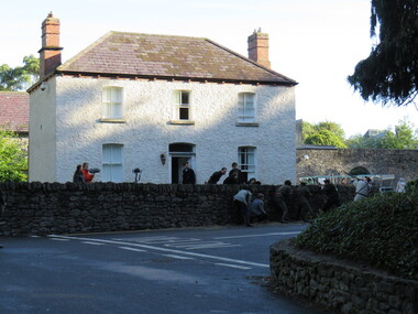
Photograph - Digital Photograph, Dorothy Wickham, Filming Fingal's Finest Day, Malahide Castle, 2016, 09/2016
Generations of the Talbot family have called Malahide Castle home. They played significant roles in Irish political and social life. Set in 260 acres the castle is only 10 minutes from Dublin airport. https://www.malahidecastleandgardens.ie/ According to wikipedia See https://en.wikipedia.org/wiki/Easter_Rising#Fingal In Fingal (or north County Dublin), about 60 Volunteers mobilised near Swords. They belonged to the 5th Battalion of the Dublin Brigade (also known as the Fingal Battalion), and were led by Thomas Ashe and his second in command, Richard Mulcahy. Unlike the rebels elsewhere, the Fingal Battalion successfully employed guerrilla tactics. They set up camp and Ashe split the battalion into four sections: three would undertake operations while the fourth was kept in reserve, guarding camp and foraging for food. The Volunteers moved against the RIC barracks in Swords, Donabate and Garristown, forcing the RIC to surrender and seizing all the weapons. They also damaged railway lines and cut telegraph wires. The railway line at Blanchardstown was bombed to prevent a troop train reaching Dublin. This derailed a cattle train, which had been sent ahead of the troop train. The only large-scale engagement of the Rising, outside Dublin city, was at Ashbourne. On Friday, about 35 Fingal Volunteers surrounded the Ashbourne RIC barracks and called on it to surrender, but the RIC responded with a volley of gunfire. A firefight followed, and the RIC surrendered after the Volunteers attacked the building with a homemade grenade. Before the surrender could be taken, up to sixty RIC men arrived in a convoy, sparking a five-hour gun battle, in which eight RIC men were killed and 18 wounded. Two Volunteers were also killed and five wounded, and a civilian was fatally shot. The RIC surrendered and were disarmed. Ashe let them go after warning them not to fight against the Irish Republic again. Ashe's men camped at Kilsalaghan near Dublin until they received orders to surrender on Saturday. The Fingal Battalion's tactics during the Rising foreshadowed those of the IRA during the War of Independence that followed. Volunteer contingents also mobilised nearby in counties Meath and Louth, but proved unable to link up with the North Dublin unit until after it had surrendered. In County Louth, Volunteers shot dead an RIC man near the village of Castlebellingham on 24 April, in an incident in which 15 RIC men were also taken prisoner.filming, fingal's finest day, malahide castle, ireland -
 Ringwood and District Historical Society
Document - Booklet, Blue & Gold - Ringwood Cricket Club Through the Years
Scanned, searchable PDF of photocopy version. 49 pages. Provided by Peter Vergers (junior) through Neville Burns.Not sure of author - either David Penny or Peter Alford, as per inscriptions on the document. Covering the years from 1901 to 1980. Also partially on RCC website - http://ringwood.vic.cricket.com.au/content.aspx?file=217|37459h. Note that the last paragraph of page 44 should read, "While the 4th Eleven Pennant was intended to close up this brief history, we cannot possibly finish without the tremendous news that in 1979/80, the fourths again got into the Final again led by Jim Myerscough and again won. They were set 295 runs to win and finished with 9/296. Plenty of heart attack and blood pressure material there! The star performer was Stephen Crump who made 138. While he would be the last to agree there is little doubt that the "Myerscough" guidance and skill played a major part in the victory and history will show that many of these lads gained enormously from Jim’s guidance and would go on to outstanding individual successes with the club." Also note that much of the Ringwood history seems to have been copied from the "Place of Many Eagles" book. Some further research on Trove has revealed that a Ringwood team was playing in 1886. -
 Orbost & District Historical Society
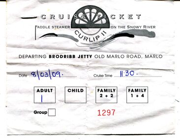
ticket, 8.03.2009
This is a ticket for one adult to cruise on the P.S.Curlip 11 which operated from the Brodribb Jetty in Marlo.from 2007 - 2015. "Paddle Steamer Curlip, a 62 feet long, traditional, plank on frame carved timber vessel, that was built by the people of East Gippsland at Orbost, in far Eastern Victoria. The undertaking to design and build this vessel, as a community project commenced in 2002. The community, based around Orbost was largely dependant on the Timber industry in the surrounding Victorian High Country. With the closure of Alpine logging and the creation of vast National Parks, the people of the region needed to create a major undertaking to bond the community and engender… a sense of belonging, this was critical for many of the men, who were dispossessed with the loss of their historical timber and forestry industry." (Information from website: https://www.curlip.com.au/) The Paddle Steamer Curlip 11 is a reproduction of the historic Curlip a small paddle steamer built by Samuel Richardson and his sons at his Tabbara sawmill near Orbost. It helped open up the region in the 1880’s before road or rail, serviced East Gippsland. Much work is being done to restore the Curlip 11 so that it can begin again as a tourist cruise boat.The P.S.Curlip 11 is Victoria's only Paddle Steamer. It was a community project involving many Orbost peolpe.A rectangular, white paper ticket with black print. In red is No. 1297 and the date and cruise time are hand-written in blue pen. ttached to the back of the ticket is a printed receipt.paddle-steamer-curlip 11 tourism-orbost -
 Eltham District Historical Society Inc
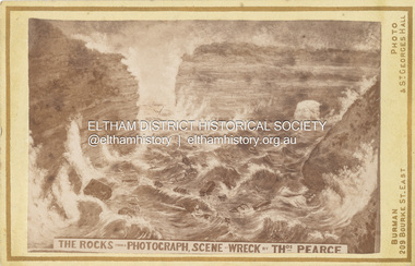
Photograph, W.J. Burman, The Rocks from a Photograph, Scene of Wreck by Thomas Pearce, 1878
Special Carte-de-Visite produced by W. Burman, July 3,1878 featuring the scene of the wreck of the ship, Loch Ard near Mutton Bird Island on the Shipwreck Coast of Victoria on June 1st, 1878. THE PHOTOGRAPHIC SOCIETY. (1878, October 12). The Age (Melbourne, Vic. : 1854 - 1954), p. 7. Retrieved December 4, 2022, from http://nla.gov.au/nla.news-article199353573 According to Sands & McDougall Melbourne Directory, Burman's were operating from 209 Bourke St. East and St George's Hall (73 Bourke St. East) from 1879-1885 Back of photo is overtsamped "Registered Copyright by W. Burman" CARTE-DE-VISITE (cdv) 1857-1890 Cartes-de-visite (cdv's) are the most common form of photograph from the nineteenth century, generally measuring two and a half inches by four and an eighth inches (6.3 x 10.5 cm) when mounted, sepia toned, mounted on a card which was generally printed with the photographer's name and address on the back or beneath the portrait. - Frost, Lenore; Dating Family Photos 1850-1920; Valiant Press Pty. Ltd., Berwick, Victoria 1991marg ball collection, 1878, 1878-1885, burman's photographer 209 bourke st east and st georges hall melbourne, loch ard (ship), shillinglaw family photo album 2 -
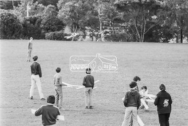
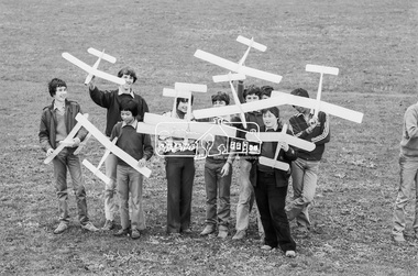
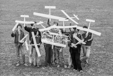
 Eltham District Historical Society Inc
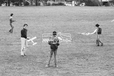
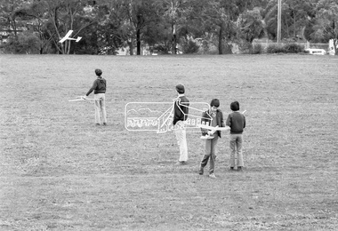
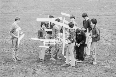
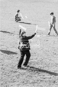
Photograph, George Coop, Balsa wood model airplane construction class, Nunawading High School, Canterbury Road, c.August 1983, 1983
Teachers at Nunawading High School were required to hold one afternoon a week with students undertaking some form of activity. There were various clubs such as gardening, chess, etc. Given George's background with art, craft and woodwork, he organised an activity for students to assemble balsa wood airplane kits which were test flown on the school grounds; Canternury Road in the background. Nunawading High School opened on Canterbury Road (near Mahoneys Road) in 1955. Enrolments grew rapidly and by 1969 there were over 1,100 students, making it one of the largest schools in the state. In 1989 it was merged with Burwood Heights High and Blackburn South High to become a junior campus of Forest Hills Secondary College. However, the junior campuses were closed in 1997, and the former Nunawading High was bulldozed to make way for a housing estate. "Lost Schools of the 1990s", Learning from the Past, http://learningfromthepast.com.au/lost-schools-of-the-1990s/ George Coop was a teacher of art, craft, wood working and graphics at Nunawading High School until it merged into Forest Hills Secondary College at which point he retired.Digital TIFF file Scan of 35mm Kodak Safety 5062 black and white transparencycanterbury road,model airplane, nunawading high school -
 Eltham District Historical Society Inc
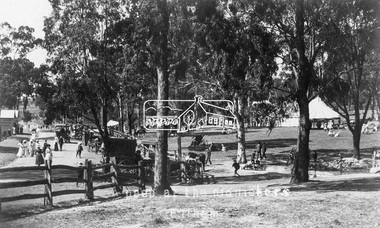
Photograph - Photograph postcard, A peep at the picnickers, Eltham, c.1904
Postcards scanned from the collection of Michael Aitken on loan to EDHS, 13 Feb 2018 Reproduced ‘Pioneers & Painters’ pp 52-53. Picnickers enjoying a Sunday outing in the fields opposite Eltham Railway Station. Looking north towards Research along Main Road near the intersection with Dudley Street. Luther Hayley’s Bakery and General Store on left promoting refreshments and summer drinks. With the opening of the railway to Eltham in 1902, Melbourne residents would regularly enjoy a Sunday excursion journey on the train to Eltham for a day’s outing to the countryside. Possibly the annual State schools picnic held by the Board of Advice at Haley's Paddock near Eltham railway station on 11 March, 1904. Haley’s Paddock (now occupied by Eltham shopping centre) was capable of accommodating 10,000 people, with ample shade and hilly surroundings, an ideal place for any gathering. The main foreground is the site of the present day Eltham Village and Coles Shopping Centre. 1904 'STATE SCHOOLS' PICNIC.', Record (Emerald Hill, Vic. : 1881 - 1954), 19 March, p. 3. http://nla.gov.au/nla.news-article165173087Digital file only Postcards scanned from the collection of Michael Aitken on loan to EDHS, 13 Feb 2018michael aitken collection, postcards, eltham, main road, bakery, eltham village reserve, general store, haley's paddock, luther haley, luther haley general store, picnic, pioneers and painters, railway store, shire of eltham pioneers photograph collection, summer drinks -
 Glen Eira Historical Society
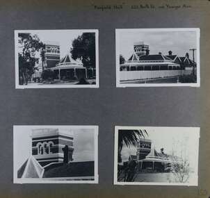
Album - Album page, Fairfield Hall, 225 North Road, Circa 1972
This photograph is part of the Caulfield Historical Album 1972. This album was created in approximately 1972 as part of a project by the Caulfield Historical Society to assist in identifying buildings worthy of preservation. The album is related to a Survey the Caulfield Historical Society developed in collaboration with the National Trust of Australia (Victoria) and Caulfield City Council to identify historic buildings within the City of Caulfield that warranted the protection of a National Trust Classification. Principal photographer thought to be Trevor Hart, member of Caulfield Historical Society. Most photographs were taken between 1966-1972 with a small number of photographs being older and from unknown sources. All photographs are black and white except where stated, with 386 photographs over 198 pages. Glen Eira Heritage Management Plan 1996 by Andrew Ward https://www.gleneira.vic.gov.au/media/4777/heritage_mment_plan_vol_3b.pdf (as of 27/01/2021) - p90 An imposing single storeyed Italianate bi-chromatic brick villa with three staged tower surmounting the entry and facetted corner bay with conical roof. White tuckpointed black body bricks are relieved with reds and stucco work. Gable ends are fretted and there is a concave cast iron verandah to the principal elevations.Victorian Heritage Database (as of 27/10/2020) - HO49 225 North Road Caulfield South https://vhd.heritagecouncil.vic.gov.au/places/42426 "Maniar" (?) is a substantial late Victorian Italianate villa with tower and extensive grounds built for Frederick Curwan, an inspector of the National Bank, in 1890. It is aesthetically and historically important. An imposing single storeyed ltalianate bi-chromatic brick villa with three staged tower surmounting the entry and facetted comer bay with conical roof. White tuckpointed black body bricks are relieved with reds and stucco work. Gable ends are fretted and there is a concave cast iron verandah to the principal elevations. It is aesthetically important as an imposing and substantially intact villa residence demonstrating the changing architectural fashions of the 1890's, evidenced by the use of face brickwork and fretted gables in the Queen Anne manner. It is historically important for the manner in which it demonstrates the lifestyle to which a businessman could aspire during the boom period.Page 150 of Photograph Album with four landscape photographs of Fairfield Hall on North Road.Handwritten: "Fairfield Hall" 225 North Rd cnr Younger Ave [top right] / 150 [bottom right]trevor hart, jenny o'donnell, verandah, porch, tower house, tower, mansion, three storey tower, bichromatic brickwork, fairfield hall, 1890's, george jobbins, conical roofed projecting corner bay, conical roofed bay, timber ceilings, north road, younger avenue, frederick wallis curwan, curwan, italianate, queen anne, australian homestead, arched windows, curved windows, columned parapet, return verandah, fairfield estate, fairfield street, slate roofed, red brick, polychrome bricks, victorian style, cast iron work, caulfield south, maniar, house names -
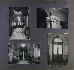
 Glen Eira Historical Society
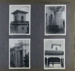
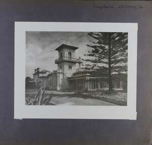
Album - Album page, Craigellachie, 273 Orrong Road, Circa 1972
This photograph is part of the Caulfield Historical Album 1972. This album was created in approximately 1972 as part of a project by the Caulfield Historical Society to assist in identifying buildings worthy of preservation. The album is related to a Survey the Caulfield Historical Society developed in collaboration with the National Trust of Australia (Victoria) and Caulfield City Council to identify historic buildings within the City of Caulfield that warranted the protection of a National Trust Classification. Principal photographer thought to be Trevor Hart, member of Caulfield Historical Society. Most photographs were taken between 1966-1972 with a small number of photographs being older and from unknown sources. All photographs are black and white except where stated, with 386 photographs over 198 pages. From Victorian Heritage Database citation HO40 Craigellachie 2b & 2c Lynedoch Avenue Caulfield North https://vhd.heritagecouncil.vic.gov.au/places/35209 as at (28/10/2020) Craigellachie" is situated at No. 2B Lynedoch Avenue, Caulfield North, and was built for the noted investor, pastoralist and politician, William Pearson, not earlier than 1864 and possible in 1876, undergoing several substantial and contributory extensions during the nineteenth century. It is historically and aesthetically significant. From Victorian Heritage Database citation for HO40 Craigellachie https://vhd.heritagecouncil.vic.gov.au/places/35209 as at (28/10/2020) It is historically significant (Criterion A) as the Melbourne home of William Pearson, MLA, MLC and principal shareholder in Walhalla's Long Tunnel Extended Gold Mining Co. which sustained the township well past the turn of the twentieth century and occupied fifth place amongst Victoria's richest mines. It is aesthetically significant (Criterion E) for its capacity to demonstrate Pearson's continuing financial success throughout the mid to late nineteenth century, the additions associated with the tower being most noteworthy as an example of the lasting appeal of the Italian Style, popularized in the pattern books of the day. The Ailanthus altissima (Tree of Heaven) is significant as an outstanding example of a species that is rare in cultivation, as well as for its very high aesthetic value. The Araucaria bidwilli is notable as a fine example of a species infrequently planted in Melbourne and rarely found in private suburban gardens.Page 156 of Photograph Album with four landscape photographs of Craigellachie - near views of architectural features. Handwritten: "Craigellachie" 273 Orrong Road [top right] / 156 [bottom right]trevor hart, verandah, orrong road, tower, curved windows, decorative brackets, italianate, mansion, 1870's, william pearson, inkerman street, apartments, spire, decorative plaster work, rendered walls, ornamentation, arched windows, moulded ornaments, 1860's, lynedoch avenue, classical style, caulfield north, craigellachie, cast iron work, victorian style, balaclava, st kilda east, gardens, ailanthus altissima, araucaria bidwilli, porches, trees -
 Glen Eira Historical Society
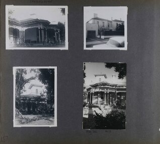
Album - Album page, Craigellachie, 273 Orrong Road, Circa 1972
This photograph is part of the Caulfield Historical Album 1972. This album was created in approximately 1972 as part of a project by the Caulfield Historical Society to assist in identifying buildings worthy of preservation. The album is related to a Survey the Caulfield Historical Society developed in collaboration with the National Trust of Australia (Victoria) and Caulfield City Council to identify historic buildings within the City of Caulfield that warranted the protection of a National Trust Classification. Principal photographer thought to be Trevor Hart, member of Caulfield Historical Society. Most photographs were taken between 1966-1972 with a small number of photographs being older and from unknown sources. All photographs are black and white except where stated, with 386 photographs over 198 pages. From Victorian Heritage Database citation for HO40 Craigellachie 2b & 2c Lynedoch Avenue Caulfield North https://vhd.heritagecouncil.vic.gov.au/places/35209 as at (28/10/2020) Craigellachie" is situated at No. 2B Lynedoch Avenue, Caulfield North, and was built for the noted investor, pastoralist and politician, William Pearson, not earlier than 1864 and possible in 1876, undergoing several substantial and contributory extensions during the nineteenth century. It is historically and aesthetically significant. From Victorian Heritage Database citation for HO40 Craigellachie https://vhd.heritagecouncil.vic.gov.au/places/35209 as at (28/10/2020) It is historically significant (Criterion A) as the Melbourne home of William Pearson, MLA, MLC and principal shareholder in Walhalla's Long Tunnel Extended Gold Mining Co. which sustained the township well past the turn of the twentieth century and occupied fifth place amongst Victoria's richest mines. It is aesthetically significant (Criterion E) for its capacity to demonstrate Pearson's continuing financial success throughout the mid to late nineteenth century, the additions associated with the tower being most noteworthy as an example of the lasting appeal of the Italian Style, popularized in the pattern books of the day. The Ailanthus altissima (Tree of Heaven) is significant as an outstanding example of a species that is rare in cultivation, as well as for its very high aesthetic value. The Araucaria bidwilli is notable as a fine example of a species infrequently planted in Melbourne and rarely found in private suburban gardens.Page 157 - four photographs of Craigellachie - exterior views. Handwritten: CRAIGELLACHIE [top left] / Neg 212 1973 [under bottom right photo] / 157 [bottom left]trevor hart, verandah, orrong road, tower, cast iron lacework, curved windows, decorative brackets, italianate, mansion, 1870's, william pearson, inkerman street, apartments, spire, decorative plaster work, rendered walls, arched windows, moulded ornaments, 1860's, lynedoch avenue, classical style, caulfield north, craigellachie, st kilda east, late victorian style, garages (private), gardens, cast iron work, ailanthus altissima, araucaria bidwilli, trees -
 Glen Eira Historical Society
Album - Album page, Craigellachie, 273 Orrong Road, Circa 1972
This photograph is part of the Caulfield Historical Album 1972. This album was created in approximately 1972 as part of a project by the Caulfield Historical Society to assist in identifying buildings worthy of preservation. The album is related to a Survey the Caulfield Historical Society developed in collaboration with the National Trust of Australia (Victoria) and Caulfield City Council to identify historic buildings within the City of Caulfield that warranted the protection of a National Trust Classification. Principal photographer thought to be Trevor Hart, member of Caulfield Historical Society. Most photographs were taken between 1966-1972 with a small number of photographs being older and from unknown sources. All photographs are black and white except where stated, with 386 photographs over 198 pages. From Victorian Heritage Database citation for HO40 Craigellachie 2b & 2c Lynedoch Avenue Caulfield North https://vhd.heritagecouncil.vic.gov.au/places/35209 as at (28/10/2020) Craigellachie" is situated at No. 2B Lynedoch Avenue, Caulfield North, and was built for the noted investor, pastoralist and politician, William Pearson, not earlier than 1864 and possible in 1876, undergoing several substantial and contributory extensions during the nineteenth century. It is historically and aesthetically significant. From Victorian Heritage Database citation for HO40 Craigellachie https://vhd.heritagecouncil.vic.gov.au/places/35209 as at (28/10/2020) It is historically significant (Criterion A) as the Melbourne home of William Pearson, MLA, MLC and principal shareholder in Walhalla's Long Tunnel Extended Gold Mining Co. which sustained the township well past the turn of the twentieth century and occupied fifth place amongst Victoria's richest mines. It is aesthetically significant (Criterion E) for its capacity to demonstrate Pearson's continuing financial success throughout the mid to late nineteenth century, the additions associated with the tower being most noteworthy as an example of the lasting appeal of the Italian Style, popularized in the pattern books of the day. The Ailanthus altissima (Tree of Heaven) is significant as an outstanding example of a species that is rare in cultivation, as well as for its very high aesthetic value. The Araucaria bidwilli is notable as a fine example of a species infrequently planted in Melbourne and rarely found in private suburban gardens.Page 158 of Photograph Album with one image of Craigellachie's exterior. Handwritten: "Craigellachie" 273 Orrong Road [top right] / 158 [bottom right]trevor hart, verandah, orrong road, tower, curved windows, decorative brackets, rendered, craigellache, italianate, mansion, 1870's, william pearson, inkerman street, apartments, spire, decorative plaster work, rendered walls, ornamentation, arched windows, moulded ornaments, 1860's, lynedoch avenue, classical style, caulfield north, craigellachie, land subdivision, gardens, late victorian style, cast iron work, st kilda east, ailanthus altissima, araucaria bidwilli, trees -
 Glen Eira Historical Society
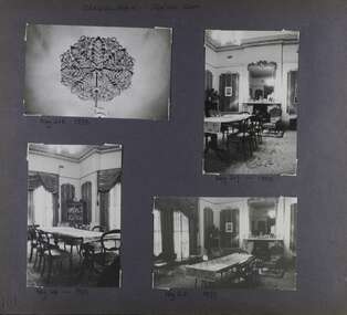
Album - Album page, Craigellachie, 273 Orrong Road, Circa 1972
This photograph is part of the Caulfield Historical Album 1972. This album was created in approximately 1972 as part of a project by the Caulfield Historical Society to assist in identifying buildings worthy of preservation. The album is related to a Survey the Caulfield Historical Society developed in collaboration with the National Trust of Australia (Victoria) and Caulfield City Council to identify historic buildings within the City of Caulfield that warranted the protection of a National Trust Classification. Principal photographer thought to be Trevor Hart, member of Caulfield Historical Society. Most photographs were taken between 1966-1972 with a small number of photographs being older and from unknown sources. All photographs are black and white except where stated, with 386 photographs over 198 pages. From Victorian Heritage Database citation for HO40 Craigellachie 2b & 2c Lynedoch Avenue Caulfield North https://vhd.heritagecouncil.vic.gov.au/places/35209 as at (28/10/2020) Craigellachie" is situated at No. 2B Lynedoch Avenue, Caulfield North, and was built for the noted investor, pastoralist and politician, William Pearson, not earlier than 1864 and possible in 1876, undergoing several substantial and contributory extensions during the nineteenth century. It is historically and aesthetically significant. From Victorian Heritage Database citation for HO40 Craigellachie https://vhd.heritagecouncil.vic.gov.au/places/35209 as at (28/10/2020) It is historically significant (Criterion A) as the Melbourne home of William Pearson, MLA, MLC and principal shareholder in Walhalla's Long Tunnel Extended Gold Mining Co. which sustained the township well past the turn of the twentieth century and occupied fifth place amongst Victoria's richest mines. It is aesthetically significant (Criterion E) for its capacity to demonstrate Pearson's continuing financial success throughout the mid to late nineteenth century, the additions associated with the tower being most noteworthy as an example of the lasting appeal of the Italian Style, popularized in the pattern books of the day. The Ailanthus altissima (Tree of Heaven) is significant as an outstanding example of a species that is rare in cultivation, as well as for its very high aesthetic value. The Araucaria bidwilli is notable as a fine example of a species infrequently planted in Melbourne and rarely found in private suburban gardens.Page 159 - four photographs of Craigellachie - three room interiors and along the verandah. Handwritten: CRAIGELLACHIE [top left] / Neg 224 1973 CHINESE SITTING ROOM [under top right photo] / Neg 226 1973 / CHINESE SITTING ROOM [under top right photo] / Neg 214 1973 DINING ROOM [under bottom left photo] / Neg 213 - 1973 [under bottom right photo] / 159 [bottom left]trevor hart, verandah, orrong road, tower, curved windows, decorative brackets, craigellache, italianate, mansion, 1870's, william pearson, inkerman street, apartments, spire, decorative plaster work, rendered walls, arched windows, moulded ornaments, 1860's, lynedoch avenue, classical style, caulfield north, craigellachie, land subdivision, gardens, late victorian style, cast iron work, st kilda east, dining rooms, sitting rooms, furnishings, tiles -
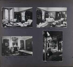
 Glen Eira Historical Society
Album - Album page, Craigellachie, 273 Orrong Road, Circa 1972
This photograph is part of the Caulfield Historical Album 1972. This album was created in approximately 1972 as part of a project by the Caulfield Historical Society to assist in identifying buildings worthy of preservation. The album is related to a Survey the Caulfield Historical Society developed in collaboration with the National Trust of Australia (Victoria) and Caulfield City Council to identify historic buildings within the City of Caulfield that warranted the protection of a National Trust Classification. Principal photographer thought to be Trevor Hart, member of Caulfield Historical Society. Most photographs were taken between 1966-1972 with a small number of photographs being older and from unknown sources. All photographs are black and white except where stated, with 386 photographs over 198 pages. From Victorian Heritage Database citation for HO40 Craigellachie 2b & 2c Lynedoch Avenue Caulfield North https://vhd.heritagecouncil.vic.gov.au/places/35209 as at (28/10/2020) Craigellachie" is situated at No. 2B Lynedoch Avenue, Caulfield North, and was built for the noted investor, pastoralist and politician, William Pearson, not earlier than 1864 and possible in 1876, undergoing several substantial and contributory extensions during the nineteenth century. It is historically and aesthetically significant.From Victorian Heritage Database citation for HO40 Craigellachie https://vhd.heritagecouncil.vic.gov.au/places/35209 as at (28/10/2020) It is historically significant (Criterion A) as the Melbourne home of William Pearson, MLA, MLC and principal shareholder in Walhalla's Long Tunnel Extended Gold Mining Co. which sustained the township well past the turn of the twentieth century and occupied fifth place amongst Victoria's richest mines. It is aesthetically significant (Criterion E) for its capacity to demonstrate Pearson's continuing financial success throughout the mid to late nineteenth century, the additions associated with the tower being most noteworthy as an example of the lasting appeal of the Italian Style, popularized in the pattern books of the day. The Ailanthus altissima (Tree of Heaven) is significant as an outstanding example of a species that is rare in cultivation, as well as for its very high aesthetic value. The Araucaria bidwilli is notable as a fine example of a species infrequently planted in Melbourne and rarely found in private suburban gardens.Page 160 - four photographs of Craigellachie interiors. Handwritten: "Craigellachie" 273 Orrong Road [top right] / 156 [bottom right]trevor hart, orrong road, italianate, mansion, 1870's, william pearson, inkerman street, decorative plaster work, rendered walls, ornamentation, moulded ornaments, 1860's, lynedoch avenue, classical style, caulfield north, craigellachie, late victorian style, st kilda east, hallways, arched doors, stained glass, mrs francis, furnishings -
 Glen Eira Historical Society
Album - Album page, Craigellachie, 273 Orrong Road, Circa 1972
This photograph is part of the Caulfield Historical Album 1972. This album was created in approximately 1972 as part of a project by the Caulfield Historical Society to assist in identifying buildings worthy of preservation. The album is related to a Survey the Caulfield Historical Society developed in collaboration with the National Trust of Australia (Victoria) and Caulfield City Council to identify historic buildings within the City of Caulfield that warranted the protection of a National Trust Classification. Principal photographer thought to be Trevor Hart, member of Caulfield Historical Society. Most photographs were taken between 1966-1972 with a small number of photographs being older and from unknown sources. All photographs are black and white except where stated, with 386 photographs over 198 pages. From Victorian Heritage Database citation for HO40 Craigellachie 2b & 2c Lynedoch Avenue Caulfield North https://vhd.heritagecouncil.vic.gov.au/places/35209 as at (28/10/2020) Craigellachie" is situated at No. 2B Lynedoch Avenue, Caulfield North, and was built for the noted investor, pastoralist and politician, William Pearson, not earlier than 1864 and possible in 1876, undergoing several substantial and contributory extensions during the nineteenth century. It is historically and aesthetically significant. From Victorian Heritage Database citation for HO40 Craigellachie https://vhd.heritagecouncil.vic.gov.au/places/35209 as at (28/10/2020) It is historically significant (Criterion A) as the Melbourne home of William Pearson, MLA, MLC and principal shareholder in Walhalla's Long Tunnel Extended Gold Mining Co. which sustained the township well past the turn of the twentieth century and occupied fifth place amongst Victoria's richest mines. It is aesthetically significant (Criterion E) for its capacity to demonstrate Pearson's continuing financial success throughout the mid to late nineteenth century, the additions associated with the tower being most noteworthy as an example of the lasting appeal of the Italian Style, popularized in the pattern books of the day. The Ailanthus altissima (Tree of Heaven) is significant as an outstanding example of a species that is rare in cultivation, as well as for its very high aesthetic value. The Araucaria bidwilli is notable as a fine example of a species infrequently planted in Melbourne and rarely found in private suburban gardens.Page 161 - four photographs of Craigellachie dining room Handwritten: CRAIGELLACHIE DINING ROOM [top left] / Neg 218 1973 [under top left photo] / Neg 217 - 1973 [under top right photo] / Neg 216- 1973 [under bottom left photo] / Neg 215 1973 [under bottom right photo] / 161 [bottom left]trevor hart, orrong road, curved windows, italianate, mansion, 1870's, william pearson, inkerman street, decorative plaster work, rendered walls, moulded ornaments, 1860's, lynedoch avenue, classical style, caulfield north, craigellachie, land subdivision, late victorian style, dining rooms, ceiling roses, furnishings, fireplaces, st kilda east -
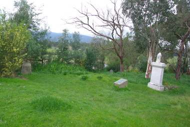
 Federation University Historical Collection
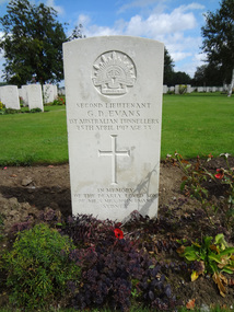
Photograph - Photograph - Colour, Caroline Winter, World War One Graves, 05/08/2012
These photographs were taken by Caroline Winter, lecturer at the University of Ballarat. Horace Pickford was born at Clunes, Victoria. He was killed in action on 27 September 1917. According to his dossier Pickford was in the 58th battalion and was buried in the vicinity of Polygon Wood. Glyndwr Evans was a native of Treorchy in the Welsh Rhondda Valley. He emigrated to Australia with his parents who lived at Randwick in New South Wales. He attended the Ballarat School of Mines, and served on the Student's Magazine Committee in 1905. The following year Glyndwr took up a position as a solutionist at the Golden Horseshoe Mine at Kalgoorlie. In the application for a commission in the AIF Glyndwr stated at he had completed three years at the Ballarat School of Mines, obtaining a Mine Manager's Certificate of Competancy, an Assayers Certificate and additional certificates in Land Surveying, Electrical Technology, Metallurgy and Geology. Gyndwr was a member of the AIF 1st Australian Tunnelling Coy. He was killed in Action at Hill 60 on 25 April 1917 and is buried in Belgium at the Railway Dugout Burial Ground (Plot VII, Row G, Grave 33). (http://guerin.ballarat.edu.au/aasp/is/library/collections/art_history/honour-roll/honourroll_Evans.shtml) A number of colour photographs of World War One war graves of soldiers from the Ballarat district. .1) Horace Pickford's headstone, Tyne Cot Cemetery .2) Glyn Evans tombstone, Railway Dugouts Cemetery south of Ypres. 3. Railway Dugouts Cemetery, Glyn Evans tombstone has a poppy on it. university of ballarat, world war one, war graves, war cemetery, world war i, world war, pickford, evans, horace pickford, harry pickford -
 Federation University Historical Collection
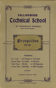
Booklet, Collingwood Technical School Prospectus, 1913, 1913
In the early years of the 20th century adequate technical education was lacking and became a focus in the Victorian Parliament. After much debate and discussion among politicians and educationalists, the 1910 Education Act No 2301 was passed, making possible the establishment of new technical schools to address the dearth of skilled trades people. In July 1912 Collingwood Technical School opened in the modified bluestone buildings at 35 Johnston St, originally built in 1853 as the Collingwood Town Hall and Court House. Within three weeks, there were 57 boys enrolled - studying preliminary carpentry and pattern-making, plumbing, engineering, sheet iron work and bricklaying. They attended two hours a night on three evenings a week. In 1913, the school opened its doors to juniors and took residence in new permanent buildings erected on the site. It was classified as a trades school by the State Education Department. Two years later courses in electrical wiring and electrical and mechanical engineering were introduced. In 1988 Preston College of TAFE and Collingwood College of TAFE merged to become Northern Metropolitan Institute of TAFE (NMIT). (http://victoriancollections.net.au/organisations/northern-melbourne-institute-of-tafe)Brown soft covered booklet of 40 pages. The contents include information relating to the Collingwood Technical School on 1913, including: Council members, constitution, standing orders, aim of the school, scholarships, advice to parents, Railway Fares, tram fares, General Rules to Students, Syllabus, English, Geography, Civics, Mathematics, Elementary Science, Woodwork, |Sheetmetalwork, evening course, carpentry, plumbing, joinery, and a list of students for 1912 Evening courses. collingwood technical school, collingwood, tafe, nmit, northern metropolitan institute of tafe -
 Federation University Historical Collection
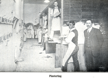
Booklet, Collingwood Technical School Prospectus, 1914, 1914
In the early years of the 20th century adequate technical education was lacking and became a focus in the Victorian Parliament. After much debate and discussion among politicians and educationalists, the 1910 Education Act No 2301 was passed, making possible the establishment of new technical schools to address the dearth of skilled trades people. In July 1912 Collingwood Technical School opened in the modified bluestone buildings at 35 Johnston St, originally built in 1853 as the Collingwood Town Hall and Court House. Within three weeks, there were 57 boys enrolled - studying preliminary carpentry and pattern-making, plumbing, engineering, sheet iron work and bricklaying. They attended two hours a night on three evenings a week. In 1913, the school opened its doors to juniors and took residence in new permanent buildings erected on the site. It was classified as a trades school by the State Education Department. Two years later courses in electrical wiring and electrical and mechanical engineering were introduced. In 1988 Preston College of TAFE and Collingwood College of TAFE merged to become Northern Metropolitan Institute of TAFE (NMIT). (http://victoriancollections.net.au/organisations/northern-melbourne-institute-of-tafe)Red soft covered book of 60 pages. Contents include: List of President, Council and staff, constitution, aim of the school, scholarships, evening classes, advice to parents, Railway fares, tram fares, free travel, general rules for students. syllabus of work, evening work. Images include carpentry class, Bricklaying, plastering and Turning & Fitting classcollingwood technical school, collingwood, tafe, nmit, northern metropolitan institute of tafe, carpentry, bricklaying, plastering, turning and fitting -
 Coal Creek Community Park & Museum
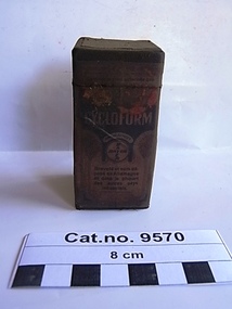
Box, medicine, post 1930 after the new town of Leverkusen was named
Email from "Heike Dansard" Only two specimens remain in the Bayer archival collection. ref: email in 'Historical Information'.Oiled rectangular thick cardboard box with printed text on paper label on outside containing white crystalline powder. Top of box lifts off as lid.On box top : BAYER BAYER' as a cross with 'Y" as the centre set in a circle in a square margin. side 1. 'CYCLOFORM FabinFabriken orm (?) FRIEDR.BAYER & Co leverkusen a/ Coln a/ Rh pharmaceohscbe.......'. Side 2. ......'CYCLOFORM............BASYER BAYER Brevate et nom depose en Allamagne et dans la pluparet des autres pays industrials'. (translation : Patent name and deposited in Germany and most other industrial countries). Side 3. ' ......Weiderwerkaul..................in...........CYCLOFORM.........MARKE BAYER BAYER..................Name.....MARKE..................und.............ichgeschuzt.........ubrigon.anaesthetic -
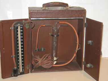
 Royal Australian and New Zealand College of Obstetricians & Gynaecologists (RANZCOG)
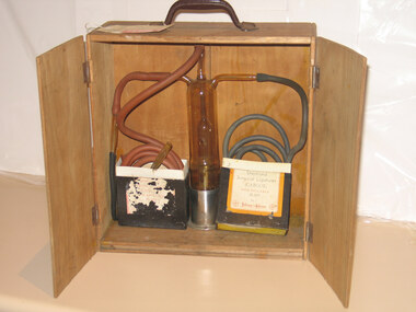
Rubin's tubal insufflator apparatus associated with St Vincent's Hospital, c1919
"Potential blockage in the Fallopian tubes was assessed using this apparatus. It was developed by American gynaecologist Isidor Clinton Rubin (1883-1958). It blows carbon dioxide, via a cannula, into the uterus. The ease with which gas escaped through the Fallopian tubes was reflected by pressure changes on an instrument called a manometer. Blockage of the tubes is often due to previous infection or surgery. It is a common cause of infertility. Rubin’s test formed a standard part of infertility investigations for many years. It was gradually replaced by an X-ray technique involving radio-opaque ‘dye’ injected into the uterus." Source: Science Museum Group. Rubin’s apparatus for uterotubal insufflation, New York, United States, 1928. A639503Science Museum Group Collection Online. Accessed 12 June 2024. https://collection.sciencemuseumgroup.org.uk/objects/co96774/rubins-apparatus-for-uterotubal-insufflation-new-york-united-states-1928-tubal-insufflator. There is no manometer to monitor gas pressure on this model so it is either incomplete or a manometer was not available in this possibly early model. This device may be dated c1919, 1920s, or 1930s. 1919 was the year Isidor Clinton Rubin (1883-1958) introduced this apparatus. Rubin's tubal insufflator apparatus. Consists of a large cylindrical glass canister, with three glass nozzles at top with long rubber tubing attached to each. The device is inside a portable plywood box with two door. One surgical steel introducer, and one glass introducer, are also attached to the device. -
 Victorian Interpretive Projects Inc.
Photograph - Colour, Clare Gervasoni, Corenderrk Cemetery, 31/08/2011
In 1860 the Wurundjeri Elder, Wonga, petitioned the Victorian Parliament for a piece of land in his people’s own country where he could establish a settlement. The land later named Coranderrk was granted. When Wonga died in 1875 his nephew William Barak, known by settlers as ‘King William, last chief of the Yarra Yarra tribe’, became the leader, the Ngurungaeta. William Barak believed strongly in justice for his people, and time and again made the arduous walk to Melbourne to petition to Parliament and to Queen Victoria for his people. ‘Freedom for our lifetime’, he said. The community at Coranderrk welcomed Aboriginal people displaced from other parts of Victoria; they established an economically self-sufficient settlement by growing and marketing hops. Barak negotiated with the Victorian Government officials as they made promises and broke promises. They finally promised to export the whole of a hop harvest of one year. The people worked around the clock to fill the contract; the Government pocketed the proceeds. The community never recovered. Barak died in 1903— a broken-hearted man. (from http://www.sosj.org.au/_uploads/_cknw/files/Corenderrk.pdf) Artist William Barak is buried in this cemetery.Photographs of graves in grass and bushland. It is the Corenderrk Cemetery, and is associated with the former Corenderrk Aboriginal Reserve.corenderrk, wurundjeri, barak, aborigines, aboriginal, cemetery, grave, barak, jemima dunolly -
 Royal Australian and New Zealand College of Obstetricians & Gynaecologists (RANZCOG)
Tubal insufflator associated with Dr Lorna Lloyd-Green, c1919
"Potential blockage in the Fallopian tubes was assessed using this apparatus. It was developed by American gynaecologist Isidor Clinton Rubin (1883-1958). It blows carbon dioxide, via a cannula, into the uterus. The ease with which gas escaped through the Fallopian tubes was reflected by pressure changes on an instrument called a manometer. Blockage of the tubes is often due to previous infection or surgery. It is a common cause of infertility. Rubin’s test formed a standard part of infertility investigations for many years. It was gradually replaced by an X-ray technique involving radio-opaque ‘dye’ injected into the uterus." Source: Science Museum Group. Rubin’s apparatus for uterotubal insufflation, New York, United States, 1928. A639503Science Museum Group Collection Online. Accessed 12 June 2024. https://collection.sciencemuseumgroup.org.uk/objects/co96774/rubins-apparatus-for-uterotubal-insufflation-new-york-united-states-1928-tubal-insufflator. Model may be dated c1919 or 1920s or 1930s. 1919 was the year Isidor Clinton Rubin (1883-1958) introduced the apparatus. Instrumant has a label with Cyrus Jones monogram " Donated by Dr Lorna Lloyd Green, 1986/ Rubin's Insufflator/ NB "sparklet holder separate" missing?Rubin's tubal insufflator apparatus, large cylidrical glass canister inside a portable carry box with two doors with three glass nozzels at top with long rubber tubing attached on each. One surigical steel introducer, one glass introducer attached. A blood pressure manometer is fixed on the inside door. infertility -
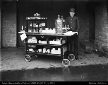 Puffing Billy Railway
Equipment - Refreshments services Trolley, 1990s
The Refreshment Services Branch was established in 1920, and initially focused on providing station-based refreshment rooms and the dining car service. Its scope expanded to include diverse activities such as stall rental; sales of advertising space on railways infrastructure; laundry services; operation of a hair-dressing salon, a bakery, a butchery and a poultry farm; and the management of the chalet guesthouse at Mt Buffalo. The majority of staff worked in refreshment rooms and dining cars, both of which were a popular feature of the railway service. Previous to 1920 refreshment services had been provided by contractors, but after many complaints the Department decided to provide a standardised service across the system. It grew quickly: five years after it was established the Branch employed approximately 500 staff. Station refreshment facilities ranged from elaborate dining rooms to decorated push-carts. They were staffed predominately by women, who provided everything from a cup of tea to a three course meal. Most refreshment room services were closed in the 1970s. Reference from : Fielding, K. (2012) Victorian Railways - Refreshment Services Branch in Museums Victoria Collections http://collections.museumvictoria.com.au/articles/11470Historic - Replica of a a Victorian Railways Refreshment Services Serving Trolley used on Puffing Billy Railway Replica large wooden serving cart with fitted wooden cabinet featuring sliding glass doors and one glass shelf. Cart has chrome handles, two wooden shelves, a wooden drawer with chrome handle and a small chalkboard adhered to end. Cart has four small black rubber and metal wheels and a metal foot brake.puffing billy, serving trolley, replica, dining cart, refreshment services, victorian railways -
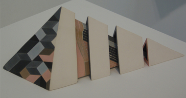 Federation University Art Collection
Ceramic - Artwork - Ceramics, "Four Part Triangular Form' by Kingsley Marks, 1984, c1984
Kingsley MARKS (1929 - ) Kingsley Marks trained at the South Australian School of Art before teaching secondary schools. He became interested in pottery after attending a class one night a week at the John Martins building in Adelaide. He received grants to travel and study ceramics in Mexico the US and Canada, then taught for twenty years at the Torrens and South Australian Colleges of Advanced Education. Upon his retirement in 1985, he moved to Brentwood near Minlaton and established the Brentwood Pottery, specialising in sculptural work using a range of forming, decorative and firing techniques. (https://www.flickr.com/groups/1281707@N21/discuss/72157641492795284/) Kingsley Marks was a guest at Strezleckie Spotkanie in 1984. This work is part of the Jan Feder Memorial Ceramics Collection. Jan Feder was an alumna of the Gippsland Campus who studied ceramics on the campus. She passed away in the mid 1980s. Her student peers raised funds to buy ceramic works in her memory. They bought works from visiting lecturers who became leading ceramic artists around the world, as well as from many of the staff who taught there.Electric kiln-fired slipcast decorated earthenware. Kevin Marks uses the mark "K" on his work. Gift of the Artist, 1984ceramics, kingsley marks, artwork, gippsland campus, churchill, brentwood pottery, artist, jan feder memorial ceramics collection -
Federation University Art Collection
Artwork - Ceramics, Ceramic Forms by Elsa Adern
Elsa ADERN (1918-2006) Born New Zealand Arrived Melbourne 1942 Elsa Ardern was living at Warrandyte in 1954 when she started studying pottery under John Bernard Knight at the Melbourne Technical College. In 1961 she was a founding member of Potters' Cottage at Warrandyte with friends Sylvia Halpern and Kate Janeba. She worked from a studio under the family home, exhibiting at the cottage and also through the Victorian Ceramic Group when it was set up in 1969. In 1980 she established a workshop at Tathra on the far south coast of NSW, sharing her time between Tathra and Warrandyte for the next 25 years. Amongst the work made at Tathra were some very large pieces which she fired in the Stafford Brothers' wood-fired brick-kiln at Kalaru. Part of the clay for these came from the Staffords' clay-pits. Elsa Adern is known for her strong form of her pots, enhanced by her characteristically subtle wood-ash glazes. Her works are signed with an incised 'Elsa Ardern' or 'EA'. (http://www.australianpotteryatbemboka.com.au/shop/index.php?manufacturers_id=32)available, elsa adern, available ceramics, ceramics