Showing 123697 items matching "main-road"
-
 Canterbury History Group
Photograph - Street view of the Bank at No. 121 Maling Road, Jan Pigot, 27/03/1993 12:00:00 AM
Coloured photograph of of the street view of the Commonwealth Bank at No. 121 Maling Roadcanterbury, maling road, shops, streetscapes, banks -
Lakes Entrance Historical Society
Map - Map of Proposed Subdivision Lake Bunga Road County of Tambo, Paul Miller and Associates, 2000c
Proposed subdivision Lake Bunga Road Township of Cunninghame County of TamboDimensions shown are approximate and subject to surveydevelopment, surveying, housing -
 Federation University Historical Collection
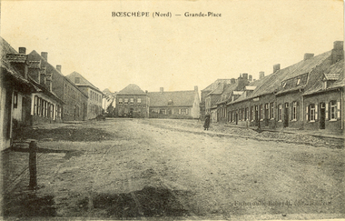
Postcard - black and white, Grande-Place, Boeschepe, c1914
Boeschepe is a commune in the Nord department in northern France, next to the Belgian border.Black and white postcard showing a number of buildings lining an unmade road. chatham-holmes family collection, boeschepe, france, world war, world war 1, grande place -
 Whitehorse Historical Society Inc.
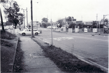
Photograph - B/W Photograph, Railway Crossing Mitcham, 1/09/1976 12:00:00 AM
Black and white photo of Railway Crossing, Mitcham Road, looking northmitcham road, mitcham, railway crossings -
 Whitehorse Historical Society Inc.
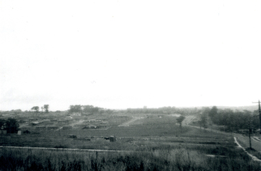
Photograph, Subdivision of Area of Burwood, 1971
Black and white photo of Subdivision of Area of Burwood, Springvale and Highbury Roads.highbury road, burwood east, springvale road, burwood highway burwood east, subdivision -
Lakes Entrance Historical Society
Map - Shire of Tambo Road Map
Road locality map from from Lakes Entrance to NSW bordermaps, settlement, roads and streets -
Canterbury History Group
Newsletter, Committee of Management; Jennifer George; Karen Kennon; Jan Pigot, Canterbury News No.5
Community newsletter featuring a 1906 photograph of Canterbury Station and Canterbury Roadcanterbury, canterbury road, canterbury station, canterbury gardens, canterbury library, goldings hall, horse drawn vehicles, shops, canterbury baptist church, rice> jim, williams> allan (dr) -
 Ararat & District Historical Society (operating the Langi Morgala Museum)
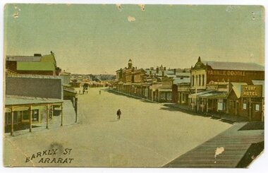
Postcard, Barkly Street Ararat
Barkly Street is the main road into the business district of Ararat and has developed significantly since this image was taken. The postcard helps define the township in its early stages of colonialisation and reflects on the style of early architecture. The image is a photographic representation of wide streets, assorted businesses and buildings with a bicyclist and horse-drawn carriage in the background. The vantage point seems to be the balcony of Leopolds hotel. This early 1900s streetscape assists in the understanding of our township's development over the decades, both socially and architecturally.Small, landscape orientation rigid postcard, colourised, featuring Barkly Street in Ararat, circa 1900s. Notable features are the Turf Hotel sign and the lettering 'Yankee Doodle' on a building wall.Front: "Barkly Street Ararat". barkly street, ararat, 1900s, buildings, streetscape, architecture, postcard, colourised, turf hotel, leopolds hotel -
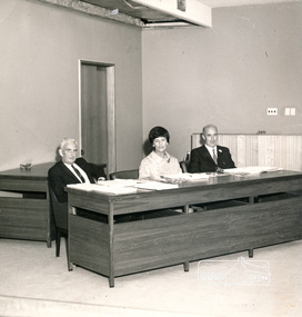 Eltham District Historical Society Inc
Photograph, Councillors Jim White, Charis Pelling and Bill Hale, Shire of Eltham, 1971
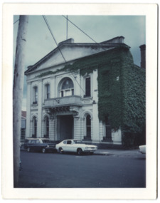
Formal photograph of Shire of Eltham Councilors, Shire of Eltham Council chambers. (Main road Eltham, now demolished). From left: Councilors Jim White, Charis Pelling and Bill Hale Probably taken by Hugh Fisher 82 Lygon St, Brunswick 3057, 6 York St, Eltham 3095, as it is similar to two other photos: 01689 and 01689-2Black and white print 17 cm x 17.5 cmcouncilors, shire of eltham, charis pelling, bill hale, jim white -
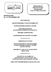 Eltham District Historical Society Inc
Newsletter, Newsletter, No. 117 November 1997
Contents: • Next meeting, guest speaker; Keith Banks: Lighthouses of Eastern Victoria • November Meeting • Christmas Function • Visitors from Eltham • Council Matters • 728 Main Road – President’s Report • Monument Hunting the Hume and Hovell Way by Diana Bassett-Smith • Irvine Green OAM 1913-1997 • The Last Cry (Mick Woiwod) • Some Other Matters The Shire of Eltham Historical Society was formed in October 1967. The first newsletter of the Society was issued May 1978 and has been published continuously ever since on a bi-monthly basis. With the cessation of the Shire of Eltham in late 1994, the Society's name was revised to Eltham District Historical Society and this name first appeared with issue No. 103, July 1995. The collection of the Society's newsletters provides a valuable resource on the history of the Society's activities, office bearers and committee members, guest speakers and subjects of historical interest pertinent to the former Shire of Eltham and the Eltham District.A4 photocopied newsletter distributed to membersnewsletter, eltham district historical society, shire of eltham historical society -
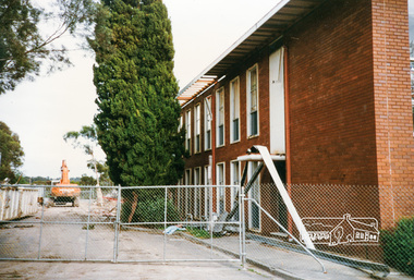 Eltham District Historical Society Inc
Photograph, Cr. Peter Graham, Mediterranean Cypress Pine trees at front of Shire office building, 12 Aug 1996, 12/08/1996
Demolition of the former Shire of Eltham Offices, 895 Main Road, Eltham, 12 August 1996. These Mediterranean Cypress Pine trees are part of the original Shillinglaw farm and stood in front of the cottage before it was relocated in 1966-67 to make way for the new Shire Office building. Originally mounted as a group of 9 photos on 42 x 55 cm display card.Colour photographeltham shire office, shillinglaw trees, demolition -
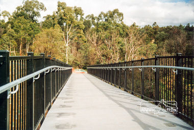 Eltham District Historical Society Inc
Photograph, Doug Orford, Completion of bridge works across Yarra River at rear of Eltham Lower Park, July 2004, July 2004
Brand new Eltham-Templestowe footbridge over the Yarra River off Homestead Road, Eltham which was completed in July 2004. The Yarra River Footbridge was opened in August 2004 and links the Diamond Creek Trail between the Shire of Nillumbik and City of Manningham. It is a shared pathway and also links with the Main Yarra Trail. It affords lovely views over the Yarra River.One of three colour photographs.yarra river, eltham south, eltham lower park, lenister farm, homestead road, shared pathway, diamond creek trail, footbridge -
 Eltham District Historical Society Inc
Negative - Photograph, George W. Bell, Re-erection of Shillinglaw Cottage, c.1966
View looking up from near the Eltham Railway Trestle Bridge over what was to become the Eltham Common at Shillinglaw Cottage in its new location prior to restoration. The former Gahan house, seen in the background was demolished in 1968 when the Main Road was duplicated in this section. The Eltham Common was taken over with the construction of the new Eltham Library which opened in 1994.Shillinglaw Cottage is itself historically, aesthetically and socially significant to the Shire of Nillumbik and is registered on the Victorian Heritage Database. This photo forms part of a collection of photographs gathered by the Shire of Eltham for their centenary project book, "Pioneers and Painters: 100 years of the Shire of Eltham" by Alan Marshall (1971). The collection of over 500 images is held in partnership between Eltham District Historical Society and Yarra Plenty Regional Library (Eltham Library) and is now formally known as 'The Shire of Eltham Pioneers Photograph Collection.' It is significant in being the first community sourced collection representing the places and people of the Shire's first one hundred years.Digital image 4 x 5 inch B&W Negsepp, shire of eltham pioneers photograph collection, eltham, shillinglaw cottage, eltham shire office, gahan house, derril, gahan, george w. bell collection, houses, main road -
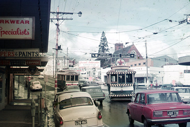 Ballarat Tramway Museum
Photograph - Digital Image, Peter Knife, Trams 18 and 17 - Stones Corner, 24/7/1971
Digital image of Trams 17 (ex Victoria St) crossing tram 18 (Mt Pleasant) at Stones Corner - the intersection of Bridge St, Victoria St and Main Road. Shows a busy and somewhat congested intersection. In the background are the Caltex Service Station, a clothing shop, paint shop, dry cleaners and parking meters. Photo by Peter Knife 24/7/1971.Yields information about tram operations in Ballarat, some two months before closure of the SEC operated tram system.Digital image of a colour slide.tramways, tramcars, ballarat, tram 17, tram 18, bridge st, stones corner -
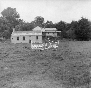
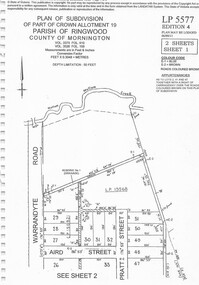 Ringwood and District Historical Society
Document - Subdivision Plan, Part of Crown Allotment 19 Parish of Ringwood, County of Mornington Vol 3375 Fol 910 & Vol 3526 Fol 159 - LP5577
LANDATA Land Victoria 2-sheet plan printout dated 6/9/2011.Sheet 1 includes Warrandyte Road, Aird Street, and Pratt Street, Ringwood, Vic. Additional markings include LP19568 Sheet 2 includes Warrandyte Road, Aird Street, Pratt Street, and White Horse Road, Ringwood, Vic. Additional markings include SP25671H, CP100154, LP10519, LP28996 and P51182. -
 Ringwood and District Historical Society
Document - Subdivision Map, Part of Crown Sections 18, 19, 24 & 25, Parish of Warrandyte, County of Evelyn, Vol 5228 Fol 472 - 1926. (Park Orchards, Victoria)
A3 and A4 sized photocopies showing map section of land title showing streets, easements and allotment numbers, some with handwritten names and pricing notations circa mid 1950s.Map includes Valley Road, Granard Avenue, Park Road, Arundel Avenue, Hylton Avenue, Aviemore Avenue, Bowmore Avenue, Hopetoun Road, Colin Avenue, Daintree Avenue, Brucedale Crescent, Feversham Avenue, Ennismore Crescent, Iona Grove, Elgin Crescent and Gosford Crescent, Park Orchards, Victoria. -
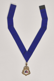 City of Greater Bendigo - Civic Collection
Ceremonial object - Rural City of Marong Medal, Blashki & Sons
The first local government authority for Marong was the Marong Road District (an early form of single-purpose local government), which was proclaimed on 19 August 1860. Its boundary was altered twice in 1862 and on 12 December 1864 it was re designated as a shire. It absorbed Raywood Borough in 1915, and was proclaimed a Rural City in 1990. On 2 December 1994, with the creation of Greater Bendigo City Council, it was abolished by being amalgamated with Bendigo City, Eaglehawk Borough, Huntly Shire, part of McIvor Shire, part of Metcalfe Shire and Strathfieldsaye Shire to form Greater Bendigo City.Rural City of Marong Stirling silver drop, plated in 22 ct gold with enamel centre piece. Medallion hangs from a royal blue neck ribbon. front; RURAL CITY OF MARONG / verso; FORMED AS / MARONG DISTRICT ROADS BOARD / 27th AUGUST 1861 / PROCLAIMED SHIRE OF MARONG / 23rd DECEMBER 1864 / PROCLAIMED RURAL CITY OF MARONG / 1st OCTOBER 1990shire of marong, city of greater bendigo ceremonial item -
 Eltham District Historical Society Inc
Photograph - Aerial Photograph, Landata, Eltham, Vic, Apr. 1963
Centred on present day John Street, Eltham between Main and Bible streets bounded by Elsa Court to north, Main Road Bridge to south, Wattle Grove to east and Bolton Street to west. Historic Aerial Imagery Source: Landata.vic.gov.au Aerial Photo Details: Project No :486 Project : MELBOURNE (1963) PROJECT Run : 6 Frame : 123 Date : 04/1963 Film Type : B/W Camera : RC8 Flying Height : 5100 Scale : 9600 Film Number : 1805 GDA2020 : 37°43'12"S, 145°08'54"E MGA2020 : 336800, 5823623 (55) Melways : 21 J6 (ed. 42)aerial photo, neil webster collection, 1963-04, bolton steet, elsa court, eltham, john street, main road, main road bridge, melway 21j6, wattle grove -
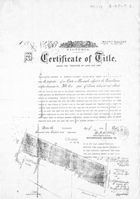 Whitehorse Historical Society Inc.
Document, Certificate of Title, 19/07/1918
Photocopy of Certificate of Title Vol. 4156 Folio 831198 for 43 acres Fronting on Canterbury Road near Mitcham Road, being part of Crown Portion 124, Parish of Nunawading, County of Bourke in the name of James Harley Malcolm, 19/7/1918. Last subdivision dated 22/5/1926- current site of Glenburnie Roadland subdivision, malcolm, james harley, mitcham road mitcham, glenburnie road mitcham, canterbury road mitcham, various surnames -
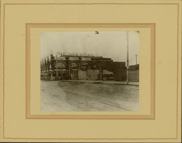 Kew Historical Society Inc
Photograph - Railway level crossing in Glenferrie Road, Glenferrie, E.J. Dower, 1912-13
One of a series of photographs, taken by Edgar James Dower in the second decade of the twentieth century. Born and raised in Olinda, his family later moved to Surrey Hills. He worked as an adult as a clerk in the city office of the Metropolitan Gas Company, and in his role as a 'collector', he was able to photograph scenes including the construction of tramlines and associated buildings in Kew, Hawthorn, Camberwell and Surrey Hills. Later he established a real estate agency with his brother - the E.J. Dower Real Estate Agency, Dandenong Office.The image is an historically significant record of the development of transport infrastructure which was used to connect Victorians in the first two decades of the twentieth century. This development resulted from increases in population and the consequent extension of Melbourne's suburbs. The photographs, both individually and collectively, richly detail the labour of workers and the tools and machinery used to create and extend Melbourne's public transport network in the years preceding and during World War 1.Digital copy of an original mounted photograph showing the old railway crossing in Glenferrie Road, Hawthorn. The removal of the train level crossing and the elevation of the rail line above the road was designed to enable the laying of tram tracks along Glenferrie Road. The buildings to the right of the photo were being demolished to allow for this. "The Don Store" is immediately behind the crossing.Annotated verso: "1912 / Demolishing shops near Glenferrie Railway Station, just prior to the regrading of line to camberwell / Taken by E.J. Dower 1912"theme --- travelling by tram, theme -- connecting victorians by transport and communications, glenferrie railway station, glenferrie road -- hawthorn (vic.), railways -- hawthorn -
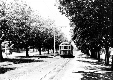 Melbourne Tram Museum
Photograph - Black & White Photograph/s, 1950's? to 1960's
Black and white photograph of W2 363 inbound, Dandenong Road showing "City", route 5, possibly at the Hawthorn Road end - between Hawthorn and Kooyong Road, Malvern. Shows the many trees, centre poles and a few motor cars on the adjacent roadway. Printed on Fujichrome paper. Not known who took the photograph or when it was printed.Stamped in black ink on back "TMSV Sales"trams, tramways, dandenong rd, tram 363 -
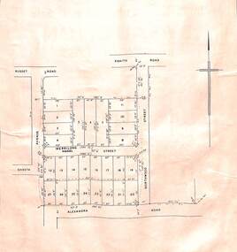 Ringwood and District Historical Society
Card - Double-sided Display, Land Subdivision Map Samples
Side 1 - Layout of 20 residential allotments in Shasta Avenue, Merrilong Street, Northwood Street and Alexandra Road, Ringwood East, Victoria (Undated). Side 2 - Extract from Land Auction advertisement for sale of 23 allotments in Ridge Road, Oakley Street and Mount Dandenong Tourist Road, Mount Dandenong, Victoria - circa 1950s. -
 Kew Historical Society Inc
Photograph - Former Kew Town Hall, Walpole Street, 1972
The Municipality of Kew was granted independence in 1860. It was declared a borough in 1863, a town in 1910 and a city in 1921. In 1994, Kew was amalgamated into the new City of Boroondara. In 1960, a new Town Hall in Cotham Road was opened. The Municipal Offices that had remained in the former Town Hall in Walpole Street until it was moved to the new Civic Centre on the corner of Cotham Road and Charles Street in 1972.This is a rare and important colour photograph of the Kew Municipal Offices (former Town Hall) taken on 11/2/1972 in the year that the building was demolished and replaced by a Safeway Supermarket.Colour photographic positive (polaroid) of the front of the (former) Kew Town Hall in Walpole Street between High Street and Malmsbury Street, on the west side where Woolworth's supermarket now stands. The photograph, taken in February 1972, shows the detailing of the Italianate rendered-brick facade, added in the 1880s when the hall was renovated. The earliest building on the site was the Kew Athenaeum Hall (built 1860) which was purchased by Kew Council in 1865. The Town Hall was sold to Woolworth's and subsequently demolished in 1972 when the civic offices were transferred to a new building on the corner of Charles Street and Cotham Road.kew town hall -- walpole street, local government -- kew, town halls -- melbourne (vic.) -
 Ballarat Tramway Museum
Photograph - Black & White Photograph/s set of 2, Charles Craig, 1950s
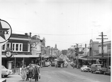
Yields information about the traffic and appearance of Bridge St during the 1950's.Set of two black and white photographs of trams in Bridge St at the intersection with Main Road and Victoria St .1 - tram at the intersection with Stones Corner and other shops in the background. Includes the Caltex services station, the Listers for Service clock and direction sign, with many people leaving the tram and walking along Victoria St. Has the Gear Chemist, Ricksha Paint and other shops in the view. .2 - No. 28 - for Gardens via Sturt St West and the intersection. Photo possibly early 1950's. Both photos by Charles Craig trams, tramways, bridge st, main road, victoria st, tram 28 -
 Melbourne Tram Museum
Ephemera - Tickets - Sandringham Tramway - Middle Brighton to Bluff Road and Royal Ave
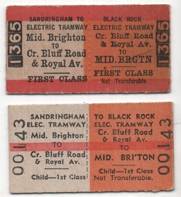
Tickets were produced to enable first-class travel from Middle Brighton Railways station to Sandringham and then by Electric Tramway from Sandringham Railway Station to the corner of Bluff Road and Royal Ave. The ticket colours indicated to station staff, Inspectors, and conductors the nature of the ticket and its availability These tickets were purchased by the donor in 1970 long after the tramway had closed and travel classes were abolished on the suburban railways. They were available for use on the replacement bus service. Yields information about the type of ticket that was issued to enable rail/tram travel on the Victorian Railways and their tramways.Set of two Edmondson style card or pasteboard Victorian Railways return tickets for travel between Middle Brighton and Bluff Road and Royal Ave. Both date stamped 15 June 1970. .1 - Adult - 1st class - No. 1365 .2 - Child - 1st class - No. 00143Both date stamped on rear "!5 June 1970"tramways, trams, tickets, victorian railways, sandringham, black rock tramway, bluff road -
 Mt Dandenong & District Historical Society Inc.
Photograph, Beauty Spots in Australia. Sassafras, c1913
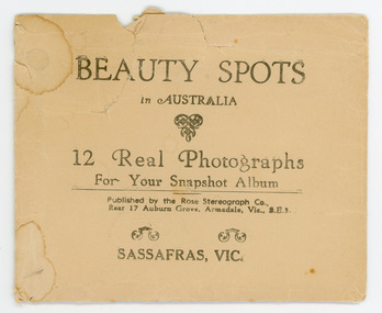
This set of small photographs was produced by the Rose Stenograph Co. c1913 to be included in photograph albums. The area known as South Sassafras, was opened up for settlement in 1893 and the name was changed to Kallista in 1925.A small, paper envelope containing 12 photographs of Sassafras that are reproductions of Rose Series postcards. There are 10 different photographs, 32a and 32c have doubles.Envelope : BEAUTY SPOTS in AUSTRALIA 12 Real Photographs For Your Snapshot Album Published by the Rose Stenograph Co. Rear 17 Auburn Grove, Armadale, Vic 3.E.3 SASSAFRAS, VICTORIA Photograph 32a - THE ROSE SERIES P. 905 CLEMATIS AVENUE, SHERBROOKE, VIC. Photograph 32b - THE ROSE SERIES P. 1603 THE CASCADES, SASSAFRAS, VIC. Photograph 32c - THE ROSE SERIES P. 204 PANORAMA AT SASSAFRAS, VIC. Photograph 32d - THE ROSE SERIES P. 4046 MAIN ROAD, SASSAFRAS, VIC. Photograph 32e - THE ROSE SERIES P. 1502 SASSAFRAS CREEK, SASSAFRAS, VIC. Photograph 32f - THE ROSE SERIES P. 1501 TOURIST TRACK, SASSAFRAS, VIC. Photograph 32g - THE ROSE SERIES P. 4244 TOURIST TRACK, SOUTH SASSAFRAS, VIC. Photograph 32h - THE ROSE SERIES P. 2725 CLEMATIS AVENUE, SHERBROOKE, VIC. Photograph 32i - MAIN ROAD, SASSAFRAS, VIC. Photograph 32j - THE OLINDA - SASSAFRAS ROAD, VIC. rose series, rose series, sassafras, sherbrooke, sassafras creek -
 Federation University Historical Collection
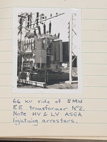
Book - Log Books, G. Beanland, Log-Books of Yarraville Laboratory, 1952-1954, 1952
Graham Beanland's logbooks for the Electrical Branch Hydro-Design Section. Beanland was later the Principal of the Ballarat School of Mines. Four foolscap books with handwritten notes. .1) includes Richmond Power Station, Midworth Statino Load Indicator Transmitter, Thomastown Experimental Line (220v), The story of Richmond, Power factor curves, dryout of 6.6. KV motor, etc .2) Pressure Tests at Mt Waverly Pump Station, Shunt capacitor Bank for Bendigo, Shepparton Main Substation, Boronia Level Crossing - Supply continuity. commissioning Warragul Main Sunstatin, Tests carried out on Sedgewick installation, Bendigo Main Substation, MMBW Instalation at McVeighs, The South-Western Story, etc .3) History of Kiewa Hydro Scheme, Kiewa Scheme Layout Plan, Kiewa No. 4 Main Transformers, Motor operatied Power-Station lift, etc (included flyers "Power From Kiewa" and "White Coal", etc .4) Newport B and C Power Station, Yarraville Maintenance Workshops, Richmond and Brusnwick Terminal Stations, Rubicon-Eildon Area, Kiewa No.3 Power Station, etc.graham beanland, electricity, kiewa power station, newport power station, yarraville, richmond terminal station, brunswick terminal station, white coal, coal, boronia level crossing lights -
 Bendigo Historical Society Inc.
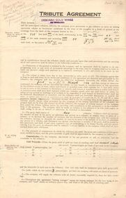
Document - MCCOLL, RANKIN AND STANISTREET COLLECTION: DEBORAH MINES NL - TRIBUTE AGREEMENT, 1934
Document: McColl, Rankin and Stanistreet: Deborah Gold Mine NL 4 copies of tribute agreements Foolscap document, agreements made between Deborah Gold Mines NL and P. Flanagan, 6 Bancroft Street, Bendigo, D. McMahon 109 Olinda Street, Bendigo, L. Balle and L. Castle, Adams Road. A. Randall, Bellevue Road, L. Watt, Allingham Street, Joseph Hocking, Bellevue Road, Golden Square, Allan Randall, Bellevue Road, Golden Square.organization, mining, deborah gold mine nl tribute mining, mccoll, rankin and stanistreet: deborah gold mine nl, goldmining, mining, tribute mining -
 Ballarat Tramway Museum
Photograph - Colour Print/s - set of 5, Carolyn Dean, Nov. 1978
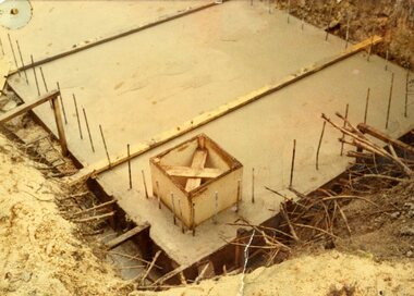
Set of five colour print of the construction of the foundation and pit of the "new shed" Nov. 1978. On Kodak paper. Date from printing date on rear of photograph. Photographer unknown. .1 - No. 4 road pit base with formwork for pump pit. .2 - Pits excavated 4 and 5 road and sand base installed. .3 - Excavating pits etc from South West corner of shed. .4 - No. 4 road pit poured. .5 - Placing concrete in No. 4 road pit. btm depot, construction, buildings -
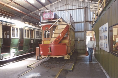 Ballarat Tramway Museum
Photograph - Colour Print/s - set of 7, Carolyn Cleak, 15/01/2012 12:00:00 AM
Yields information about the BTM Tram fleet and operations in Jan. 2012.Set of seven colour photographs taken by Carolyn or Graeme Cleak on 15/1/2012 of the depot and No. 33 in Wendouree Parade. .1 - Horse Tram with Peter Winspur walking alongside .2 - No. 8 on No. 5 road with tower truck in background .3 - No. 661 on No. 4 road .4 - No. 26 on No. 5 road .5 - No. 671 on No. 3 road .6 - No. 33 at Carlton St terminus .7 - No. 33 at St Aidans Driver terminus. Printed on Fujichrome Crystal Archive paper.On rear of each photograph is date "15.1.12" and who the photo taken by in ink.trams, tramways, btm, depot, wendouree parade, carlton st, st aidans drive, tram 33, tram 1, tram 26, tram 8, tram 671, tram 661