Showing 110304 items matching "roads"
-
 Kew Historical Society Inc
Plan, Melbourne & Metropolitan Board of Works : Borough of Kew : Detail Plan No.1592, 1905
The Melbourne and Metropolitan Board of Works (MMBW) plans were produced from the 1890s to the 1950s. They were crucial to the design and development of Melbourne's sewerage and drainage system. The plans, at a scale of 40 feet to 1 inch (1:480), provide a detailed historical record of Melbourne streetscapes and environmental features. Each plan covers one or two street blocks (roughly six streets), showing details of buildings, including garden layouts and ownership boundaries, and features such as laneways, drains, bridges, parks, municipal boundaries and other prominent landmarks as they existed at the time each plan was produced. (Source: State Library of Victoria). This plan forms part of a large group of MMBW plans and maps that was donated to the Society by the Mr Poulter, City Engineer of the City of Kew in 1989. Within this collection, thirty-five hand-coloured plans, backed with linen, are of statewide significance as they include annotations that provide details of construction materials used in buildings in the first decade of the 20th century as well as additional information about land ownership and usage. The copies in the Public Record Office Victoria and the State Library of Victoria are monochrome versions which do not denote building materials so that the maps in this collection are invaluable and unique tools for researchers and heritage consultants. A number of the plans are not held in the collection of the State Library of Victoria so they have the additional attribute of rarity.Original survey plan, issued by the MMBW to a contractor with responsibility for constructing sewers in the area identified on the plan within the Borough of Kew. The plan was at some stage hand-coloured, possibly by the contractor, but more likely by officers working in the Engineering Department of the Borough and later Town, then City of Kew. The hand-coloured sections of buildings on the plan were used to denote masonry or brick constructions (pink), weatherboard constructions (yellow), and public buildings (grey). In MMBW Plan No.1592, the pink line indicates that area of the plan for which the contracting engineer was responsible. Included in the Plan are a number of primarily brick villas in a section of Belmont Avenue off Cotham Road. The house ‘Uvadale’ north of Belmont Avenue, and facing Cotham Road is also included in the contract. Excluded from the contract but shown on the Plan are ‘Glendonald’, ‘Mont Belmont’ and ‘Gilden’.melbourne and metropolitan board of works, detail plans, survey plans - borough of kew, mmbw 1592, cartography -
 Kew Historical Society Inc
Photograph - 'Mount Eri', 9 Highbury Grove, 1919
Subdivision plans are historically important documents used as evidence of the growth of suburbs in Australia. They frequently provide information about when the land was sold on which a built structure was subsequently constructed as well as evidence relating to surveyors and real estate and financial agents. The numerous subdivision plans in the Kew Historical Society's collection represent working documents, ranging from the initial sketches made in planning a subdivision to printed plans on which auctioneers or agents listed the prices for which individual lots were sold. In a number of cases, the reverse of a subdivision plan in the collection includes a photograph of a house that was also for sale by the agent. These photographs provide significant heritage information relating house design and decoration, fencing and household gardens.A photograph of Mount Eri, 9 Highbury Grove, an 11-room house for sale near the junction of Cotham and Glenferrie Roads. The substantial red brick, slate-roofed house and its location are not identified in the photograph, although the extent of the house is noted. It was described then as ‘well situated’ and close to 3 trams. Mathers, a financial agent in Cotham Road, placed advertisements about the sale of the property in The Argus in May and June 1919. The advertisement additionally refers to a billiard room and asserts that the house has every modern convenience. An annotation on the plan indicates that the house, with tennis court, was sold for £1960. Following extensive research, the house has now been conclusively identified, albeit extended and rendered. The house was originally built in the 19th century as a school and for much of the 20th century was used as a venue for receptions. -
 Kew Historical Society Inc
Archive (Sub-series) - Subject File, Kew Historical Society, Houses [Kew], 1980
Various partiesReference, Research, InformationSecondary Values (KHS Imposed Order)Assorted printed materials, some published, such as: ‘What House is That? A guide to Victorian housing’ (Heritage Victoria, 2004), and guidelines for researching the history of a house (Fact Sheet, City of Boroondara). There is an article from the Progress Press about the demolition of Ellesmore, 80 Princess Street in 1977 (the article includes photographs of the demolition), Elizabeth Mackie’s notes on Myrtle Hill, and an article on the restoration of Mynda, Molesworth Street that was published in the Trust News (1987). Mrs Sewell of Stawell Street wrote handwritten notes/recollections about Cradley in Studley Park Road in 1981. In the photocopy about Ellesmore, there is also a separate article on the proposed replacement of the Walmer Street Bridge. There is also correspondence and an article on Stanhope on the corner of Burke and Cotham Roads. The file includes general real estate information and data.kew historical society - archives, kew - history, myrtle hill (kew), ellesmore - 80 princess street - kew (vic), mynda - molesworth street - kew (vic), stanhope - burke road - cotham road - kew (vic), cradley - studley park road - kew (vic), 17 queen street - kew (vic.)kew historical society - archives, kew - history, myrtle hill (kew), ellesmore - 80 princess street - kew (vic), mynda - molesworth street - kew (vic), stanhope - burke road - cotham road - kew (vic), cradley - studley park road - kew (vic), 17 queen street - kew (vic.) -
 Kew Historical Society Inc
Plan - Subdivision Plan, Erin Heights Estate, East kew, 1917
Pru Sanderson, in her groundbreaking ‘City of Kew Urban Conservation Study : Volume 2 - Development History’ (1988), summarised the periods of urban development and subdivisions of land in Kew. The periods that she identified included 1845-1880, 1880-1893, 1893-1921, 1921-1933, 1933-1943, and Post-War Development. These periods were selected as they represented periods of rapid growth or decline in urban development. An obvious starting point for Sanderson’s groupings involved population growth and the associated economic cycles. These cycles also highlighted urban expansion onto land that was predominantly rural, although in other cases it represented the decline and breakup of large estates. A number of the plans in the Kew Historical Society’s collection can also be found in other collections, such as those of the State Library of Victoria and the Boroondara Library Service. A number are however unique to the collection.The Kew Historical Society collection includes almost 100 subdivision plans pertaining to suburbs of the City of Melbourne. Most of these are of Kew, Kew East or Studley Park, although a smaller number are plans of Camberwell, Deepdene, Balwyn and Hawthorn. It is believed that the majority of the plans were gifted to the Society by persons connected with the real estate firm - J. R. Mathers and McMillan, 136 Cotham Road, Kew. The Plans in the collection are rarely in pristine form, being working plans on which the agent would write notes and record lots sold and the prices of these. The subdivision plans are historically significant examples of the growth of urban Melbourne from the beginning of the 20th Century up until the 1980s. A number of the plans are double-sided and often include a photograph on the reverse. A number of the latter are by noted photographers such as J.E. Barnes.The Erin Heights Estate in Kew included just seven lots in in Valerie Street. These were all that remained of this wartime subdivision, the other 11 allotments on Balfour and Belford Roads having already been sold. Balfour Road was to be only a temporary name as the street is currently called Windella Avenue. Now, the parkland opposite the subdivision is the reserve created from the route of the Outer Circle Railway. This Railway reached Kew East in 1925, but had been planned as far back as 1873. The development focuses on the benefits of living in Kew: being at the highest of Kew’s ‘suburbs’; being a good residential area; its rapid growth; and the proximity of the Kew East tram in High Street. In 1917, the electric tramline only extended to a terminus at the Harp of Erin hotel. The terminus is clearly represented on the plan.subdivision plans - east kew, erin heights estate -
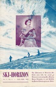 Falls Creek Historical Society
Journal - Ski-Horizon Vol 5 No 5
Ski-Horizon is the official journal of the Federation of Victorian Ski Clubs which began publication in 1949. The were 26 original member clubs which included Albury Ski Club, Bogong Ski Club, Myrtleford Ski Club, Tallangatta and District Ski Club and Wangaratta Ski Club. Two pioneers of Falls Creek, Tom Mitchell, M.L.A., and Martin Romuld were Vice-Presidents of the Federation.This Journal is significant because it documents the early development of skiing in Victoria.The journal features stories and events chronicling developments in Victoria and internationally. Items related to the Falls Creek Area in this issue include:- The front cover featured an official portrait of Her Majesty Queen Elizabeth II who was visiting Victoria with H.R.H. the Duke of Edinburgh Page 13 - There were to be virtually no restrictions on access to Falls Creek for the summer. However visitors were asked to avoid using the road above Mt. Beauty between 7-8.30 a.m. and 4-5.30 p.m. Many clubs have been building at Falls Creek and there are many things to see, including the Kiewa hydroelectric scheme. At this stage, restrictions for winter use have not been revealed. Unless major works resume on the hydroelectric scheme it is unlikely the road will be open beyond Howman's Gap.falls creek access, sec road access, royal visit -
 City of Kingston
Photograph - Black and white, 20 December 1945
Cheltenham is a suburb in the City of Kingston that was originally established as a rural market gardening community. The area is bordered by Highett, Mentone and Heatherton. The market gardens, farms and paddocks have gradually been sub-divided into housing and industrial estates. The Southland shopping centre is a major feature of the area.Cheltenham was established as a rural market gardening community. The Le Page family lived in Cheltenham since 1854 when Nicholas Le Page, a tailor from the Channel Island of Guernsey, bought two acres of land on Chesterville Road near Bernard Street to establish a market garden. Over the years the Le Pages purchased more land in the area. In 1875-76 Nicholas' son Frank and his wife Mary built 'Daphne Cottage' near the corner of Bernard and Wilson Streets. n the 1940s Frank's son, Everest Le Page, bought five more lots of land in Chesterville Road from the Tuck family. The Le Pages grazed horses, ponies and cows on this land, and grew pumpkins, carrots, parsnips, onions, potatoes and cabbages. Many buildings and locations within in Cheltenham commemorate the Le Page family's contribution to the Cheltenham community.Aerial photograph taken in 1945 of the Cheltenham district within the City of Kingston. The image includes Chesterville Road, the future site of Turner Road pool (now Waves) and Highett Reserve, (top left), Jellicoe Street, Argus Street, Bernard Street, Wilson Street, the Methodist Children Homes (now Southland), McIvor Street, Goulburn Street, Nepean Highway, Jamieson Street and Barker Street (bottom left), market gardens and paddocks. In the top centre of the image, "Daphne Cottage", the home of Frank T. Le Page is visible on the corner of Bernard and Wilson Streets. Much of the land depicted in this image was owned by the Le Page family. This image is possibly from the collection of aerial photographs commissioned by the Department of Crown Lands and Survey and taken by Adastra Airways.Black and white ink: 57250 White print: VIC-170 57250 20.12.45 Run 6 PROJ. No. 5 MELB. METROP AREA Black type 10200 FTS 30' LENS 20.12.45cheltenham, market gardens, industry, le page family -
 City of Kingston
Photograph - Black and white, 20 December 1945
This aerial photograph depicts the changing landscape of Cheltenham and Highett since WWII. Photographed in 1945, there is a mix of urban dwellings and industrial development and precedes the major transformation of Cheltenham with the development of the Southland shopping centre in the 1960s and expansion in the 1990s.A large part of Cheltenham was originally established as a rural market gardening community. The railway line and station brought urban development to the area and in the north, the Highett area was dominated by the Highett Gas Works. Cheltenham became a major destination for shopping in the 1960s with the opening of Southland.Aerial photograph taken in 1945 of Cheltenham and Highett within the City of Kingston. The image includes the Highett Reserve, (top right), the Methodist Children Homes (now Southland), Nepean Highway and Jamieson Street. Highett Gas Works is visible in the top left and the land now named William Fry Reserve at the intersection of Bay Road and Nepean Highway. A visible large parcel of land on the corner of Bay Road and Nepean Highway was developed in the 1990s as the west side addition to Southland. The densely vegetated area in the upper right sector of the image is now dense with housing. Tulip Grove, Heather Grove and Gilford Street are visible bottom left. This image is possibly from the collection of aerial photographs commissioned by the Department of Crown Lands and Survey and taken by Adastra Airways.Black ink: 57252 White lettering: VIC-10 57252 20.12.45 [lens information indecipherable] PROJ. No.5 MELB. METROP AREA Black pencil: 80highett, cheltenham, highett gas works, urbanisation -
 City of Kingston
Photograph - Black and white, 20 December 1945
This aerial photograph depicts the changing landscape of Cheltenham and Highett since WWII. Photographed in 1945, there is a mix of urban dwellings and industrial development and precedes the major transformation of Cheltenham with the development of the Southland shopping centre in the 1960s and expansion in the 1990s.A large part of Cheltenham was originally established as a rural market gardening community. The railway line and station brought urban development to the area and in the north, the Highett area was dominated by the Highett Gas Works. Cheltenham became a major destination for shopping in the 1960s with the opening of Southland.Aerial photograph taken in 1945 of Cheltenham and Highett within the City of Kingston. The image includes the Highett Reserve, (top right), the Methodist Children Homes (now Southland), Nepean Highway and Jamieson Street. Highett Gas Works is visible in the top left and the land now named William Fry Reserve at the intersection of Bay Road and Nepean Highway. A visible large parcel of land on the corner of Bay Road and Nepean Highway was developed in the 1990s as the west side addition to Southland. The densely vegetated area in the upper right sector of the image is now dense with housing. Tulip Grove, Heather Grove and Gilford Street are visible bottom left. This image is possibly from the collection of aerial photographs commissioned by the Department of Crown Lands and Survey and taken by Adastra Airways.Black type: Reverse lettering VIC-10 57252 20.12.45 [lens information indecipherable] PROJ. No.5 MELB. METROP AREA White lettering: Reverse writing 57252cheltenham, highett, highett gas works, urbanisation -
 Bendigo Historical Society Inc.
Document - H. A. & S. R. WILKINSON COLLECTION: AGREEMENT TO BUILD HOUSE
Agreement made the 3rd of January 1958 between Thomas James Roberts of 1 Ashley Street, Bendigo builder) and Peter William Tieman and Edith Ruby Tieman both of 60 Hodgkinson Street, Bendigo (owners) whereas the owners have land in Specimen Hill Road and have requested he builder to erect a dwelling house thereon. There 8 clauses on the agreement. There is also a sheet detailing the specifications for the build. Price: 2,300 pounds. Also, a paper signed by T. J. Roberts on the 3rd of January 1958 that on completion of contract for new building on block, lot 28, Specimen hill Road, Golden Square for P. W. & E. R. Tieman agreeing to pay H. A. & S. R. Wilkinson the sum of 82 pounds 10 shillings for commission due on such contract.h.a. & s.r. wilkinson, real estate, buildings -
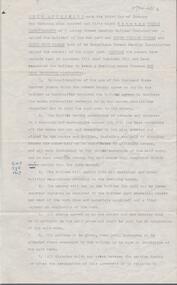
 Ringwood and District Historical Society
Document - Folder, Coolooli Estate Subdivision, Ringwood East, Vic. - Four Releases 1969-1975
Collection of Subdivision Plans, Land Sale flyers, Auction notices, and Real Estate Agent's notes for Coolooli Estate, Ringwood East, Victoria. Subdivision includes Coolooli Court, Isabel Avenue, Walhalla Drive, Cleland Street, Landell Court, Byways Drive, Heathwood Street and Hume Street, released over four stages - First Stage auction 16 August 1969, Second Release private sales from July 1970, Third Release Auction 11 September 1971, Final Release auction June 21st 1975. Agents - C.E. Carter & Son, 126 Whitehorse Road, Ringwood until moving to 122 Whitehorse Road in 1973 - Tel. 870 6024, 870 6830, 870 2519, A.H. 723 3298, 870 6960. Digitised copy of photograph - A.B. Carter and Andy McLean at Coolooli Estate auction, 11 September, 1971. -
 Melbourne Tram Museum
Document - Timetable - MMTB bus routes 1962 and 1963, Melbourne & Metropolitan Tramways Board (MMTB)
Produced by the MMTB to provide timetable information on Melbourne bus routes to passengers. Shows the extension of the Clifton Hill to Elsternwick route to Point Ormond after the closure of tram service to Point Ormond and for services that replaced the Footscray tram lines.Shows the method of production of timetables in the early 1960s.Set of 7 bus timetables, duplicated sheets as noted below - printed on foolscap sheets. .1 - Sunshine Park - City - 15/3/1963 - single sheet .2 - Sunshine (via South and Dynon Roads) - City Bus - 20/7/1962 - single sheet .3 -Garden City - City - undated - single sheet .4 - Queens Bridge - Fisherman's Bend, - via various routes - June 1963, four sheets stapled in top left hand corner. .5 - Deer Park - City - 14/11/1962 .6 - Clifton Hill - Point Ormond - Esternwick - undated .7 - Ballarat Road - Footscray Station - Williamstown Rd - Russell St - 15/6/1962 - three sheets stapled in top left hand corner.timetables, buses, mmtb, footscray, sunshine, fisherman's bend, clifton hill, point ormond, garden city, bus replacement -
 Melbourne Tram Museum
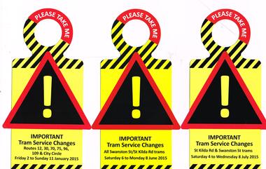
Pamphlet, Public Transport Victoria (PTV), "Tram service changes", 2015
Set of 5 pamphlets or hanging notices to around tram handrails, cut out advised of the changes to services due to tramway or other works. .1 - Routes 12, 30, 70, 75 and 96 - 2/1/2015 to 11/1/2015 for the reconstruction of the Batman Park Stop, Clarendon St and the intersection of Flinders and Spencer St. .2 - 6/6/2015 to 8/6/2015 - St Kilda Road works .3 - 4/7/2015 to 8/7/2015 - St Kilda and Swanston St trams .4 - Routes 48 and 75 - 10/10/15 to 17/10/15 and 70, 75 and City Circle - 24/10/15 to 26/10/74. .5 - Route 8 - 28/11/2015 to 2/12/15 - Toorak Road works.trams, tramways, trackwork, bus replacement, notices and information, superstops, tram stops, route 12, route 30, route 70, route 75, route 96, route 48, city circle, route 8, st kilda rd, clarendon st, flinders st, spencer st, tram 3521 -
 Melbourne Tram Museum
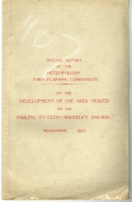
Document - Report, Metropolitan Town Planning Commission, "Metropolitan Town Planning Commission - Darling to Glen Waverley Railway - 1927", May. 1927
Report - 20 pages + 5 Maps stapled and then glued bound within a light green grey light card folder titled "Metropolitan Town Planning Commission - Special Report on the Development of the area serviced by the Darling to Glen Waverley Railway - 1927". Report looks the development that could be undertaken along the proposed Glen Waverley rail line, its town planning, Garden City type layouts, rail level crossings, new arterial roads, open spaces, financial arrangements, sewerage and water supply, zoning, legislation and conclusion. Dated 6/5/1927. Plans show possible garden city type layouts, arterial roads, possibilities within existing sub-divisions. Note that Mr. Strickland was a member of the Commission undertaking this work.Has in ink on the bottom edge "17th June 1919"trams, tramways, mmtb, tramways, development, town planning, glen waverley, darling -
 Melbourne Tram Museum
Ephemera - Timetable, Melbourne & Metropolitan Tramways Board (MMTB), Set of 13 Timetables MMTB, Oct 1966 to July 1969
Set of 13 Timetables - printed or photocopied on foolscap paper for weekdays, Saturdays and Sunday and running times. Has various symbols for depot run in etc. In a style for public use. All to the City unless noted. .1 - North Richmond - Prahran - St Kilda Beach - June 1969 .2 - Essendon Aerodrome - Nov. 1968 .3 - East Preston - July 1969 .4 - West Preston - Feb. 1969 .5 - Northcote via St Georges Road - May 1967 .6 - South Melbourne Beach - Oct. 1966 .7 - North Coburg - Feb. 1969 .8 - East Coburg - Feb. 1969 .9 - West Maribyrnong - Nov. 1968 .10 - Essendon (Niddrie) - Feb. 1969 .11 - Moonee Ponds - Footscray - Feb. 1969 .12 - Domain Road - City - April 1967Most have the name of the Depot worked from and the date in the top right hand corner in ink.trams, tramways, mmtb, timetables, buses, trams, north richmond, prahran, st kilda, essendon airport, east preston, west preston, northcote, south melbourne beach, north coburg, east coburg, west maribyrnong, essendon, moonee ponds, footscray, domain rd -
 Melbourne Tram Museum
Negative, Wal Jack, 21/04/1945 12:00:00 AM
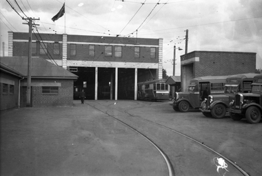
Black and white negative, by Wal Jack, of S class 168 on the western road at Footscray Tram depot. Two other S Class cars are behind 168 and on the other roads is a further S Class and X1 Class car. Shows the depot layout. There are three buses in the yard - advised by Paul Kennelly via David Kemp by e-mail: Two Leyland Cubs sandwiching a Federal B20, all with MMTB Preston Workshops bodies. The Leyland Cub closest to the camera is No 49 new 8/1936. This bus had been re-engined to Diesel by this time. May explain the missing engine cover. The other Leyland Cub maybe in the same 41-50 number sequence. The Federal B20 was new the following year and was numbered in the sequence 53-60.trams, tramways, footscray depot, buses, s class, tram 168, mmtb, mmtb buses, leyland cub, world war ii, footscray, x1 class, federal b20 -
 Melbourne Tram Museum
Negative, Wal Jack, 12/03/1946 12:00:00 AM
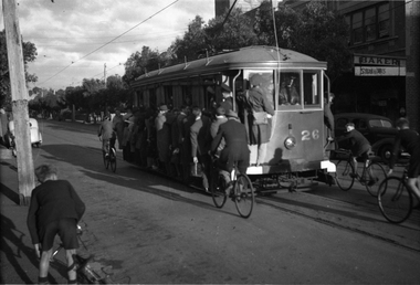
Black and white negative, of Victorian Railways tram 26 in Bay Road near depot junction - extremely overload with hangers on, footboards used and a young cyclist hanging onto the rear of the tram. Wal's album print "VR Sandringham - Black Rock Tramways - No. 26 "Toastrack" in Bay Road near depot junction - Black Rock Bound (5.55pm) 12-3-46" along with Wal Jack stamp and T555 Note the white bumper bars. A uniformed tramway man? and conductor are observing. In the background is the Roxy Theatre and the spire of the All Souls Anglican Church. (The church spire has since been rebuilt).Also in the background is the Salvation Army Hall, Barker Upholster and two buses. Photo in the Wal Jack Victorian Railways Album.trams, tramways, victorian railways, vr trams, bay road, sandringham, tram 26 -
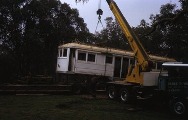 Melbourne Tram Museum
Slide - Set of 7, Len Millar, 18/04/1974 12:00:00 AM
Set of seven Kodak white cardboard 35mm colour slides by Len Millar of the move of former VR tram No. 34 from Yarrambat to the TMSV site at Bylands on 18/4/1974. Reference June 1974 issue of Trolley Wire. Note the Brill 77E trucks i the background were obtained at the same time. These would have been 5'3" gauge and it would appear that the tram was placed on a set of MMTB No. 1 trucks. Len Millar advised 21-7-2021 - that Trolley Wire says that the tram was obtained from a private property on the banks of thee Plenty River at Yarrambat, It was perched on a steep slope only 50 metres from the house, but two kilometres in from the nearest road. The track out to the nearest road was steep, rough and akin to a “goats’ track”!trams, tramways, vr trams, recovery, transporting trams, tmsv, bylands, tram 34 -
 Bendigo Historical Society Inc.
Document - HAND WRITTEN LIST OF WAR RESTRICTIONS
BHS CollectionHand written list of war restrictions: On paper with blue lines for writing, sheet came from a writing pad. War situation Ordinance Factory Guns. Con on Trams. Guards - Women in Industry - Stacking. Man power regulations. Direction of Labour. Rationing Coupon System. Black Marketing. Black out regulations - Street lighting, Shops and Homes. 100 mile inland. Road Signs. Shovels for road trenches. Petrol rationing. 4 Galls Police Supplies. Women in slacks for Winter. Power restrictions. Air raid wardens. Organise spare ........... Race course was camp. Show grounds was camp also. American troops billeted with us. Volunteer Air observers. Corps. All planes to be accounted for and ......................................................Severe Winters. Radiators banned. Box 625 -
 Melbourne Tram Museum
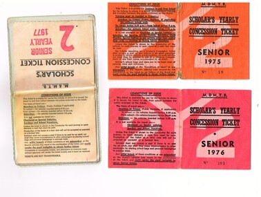
Ephemera - Ticket/s, Melbourne & Metropolitan Tramways Board (MMTB), "Scholar's Yearly Concession Ticket", 1975 to 1977
Set of two clothed backed paper tickets, printed as a MMTB "Scholar's Yearly Concession Ticket", for Seniors and one paper ticket contained within a plastic envelope. Gives condition of use on the outside cover. Each issue to Roderick Atkins. Each lists the various terms for which they were available and available from Cotham and Glenferrie Road, to Callantinia Road, Scotch College. Two sections. .1 - Orange cloth, Senior 1975, cost not shown No. 18 .2 - red cloth, Senior 1976, cost $39.00 No. 203 issued at Doncaster Depot .3 - light yellow paper within a plastic envelope, Senior 1976, cost $39, No. 42583, issued at Kew Depot. See Reg Item 5571 for other examples of item 3trams, tramways, mmtb, tickets, schools, schools tickets, scholar's tickets -
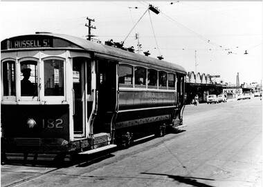 Melbourne Tram Museum
Photograph - Set of 3 Black & White Photograph/s, 1960's
A series of three Black and white photographs of tram T class 182 at the Williamstown Road terminus of the Footscray tram system, c1960. Tram photograph in Somerville Road. All showing the return destination of Russell St. .1 - Shows the shops in the background. Trolley pole reversed and appears the driver is about to enter the cab of the tram. Has the run number F6. Has a Caltex, Ampol, Kix and Caravan park sign in the background. .2 - 182 at the terminus with trolley pole reversed and under the wheel locating guard. Has Run No. F5 in the rear cabin window. .3 - ditto, but before trolley pole reversed with passengers leaving the car and one lady waiting to board. Printed on Fujichrome paper. Not known who took the photograph or when it was printed. Two copies of .1 held.Stamped in black ink on back "TMSV Sales"trams, tramways, footscray, williamstown rd, somerville rd, tram 182, t class, mmtb -
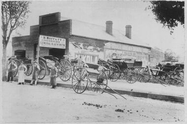 Bacchus Marsh & District Historical Society
Photograph, H.Moffatt Coachbuilder General Blacksmith Main Street Bacchus Marsh
H. Moffatt, blacksmith, opened new brick premises in 1899 on the site of a similar building burnt down the previous year. He continued to operate as a coachbuilder and blacksmith on this site until 1927 when he retired. Since then, the premises have been used for coffin making, a hardware store, furniture store, bathroom supplies among other things. It is now operating as Lola's Restaurant.Black and white photographic print. Dating from the early 1900s, this photograph is of a substantial brick building opened in 1899 by Mr H. Moffatt at 110 Main Street on the site of a similar building which burnt down in 1898. A sign at the front reads: H.MOFFATT COACHBUILDER GENERAL BLACKSMITH. A number of horse-drawn carriages, two and four-wheeled, stand on the footpath, roadway and on the vacant block next door. The road appears to be unmade and is separated from the elevated footpath by barge boards. Advertising signs line the side wall of the building. Four men stand on the road, three wearing the leather apron worn by blacksmiths, one wearing a long white apron as was often worn by shop assistants. Horse droppings, a common sight in those days, can be seen on the roadway. shops bacchus marsh vic., main street bacchus marsh vic., h. moffatt, coachbuilders, general blacksmiths -
 Kew Historical Society Inc
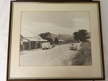
Photograph - Country Roads Board and Denmark Street Baby Health Centre, Ron Setford, 1961
Ron Setford and his wife Grace Setford lived in Tanner Avenue, East Kew, from c.1946 to c.1995. A keen photographer, he recorded the changing face of Kew over a 20 year period. Apart from 30 photographs of built structures and places in Kew dating from 1960 and 1961, 145 of his 35mm colour slides chronicle the development of the Eastern Freeway through the Yarra Valley over a five year period from c.1972 to c.1977. This important collection was donated to the Society by his granddaughter in 2025.This collection of 175 35mm slides is of local and statewide significance, owing to its subject matter, particularly the major development of road transport infrastructure during the 1970s with the construction of the Eastern Freeway. The photographer also took care to annotate and date most of his slides which enable the researcher to pinpoint temporal and spatial locations.A photograph providing a visual contrast of the pre and post-World War II architectural styles of the Denmark Street Baby Health Centre and two of the Country Roads Board office buildings. Each was built on part of the land fronting the Kew branch line. In May 1939, the Railway Commissioners agreed to lease a site at the Kew Railway Station for a Baby Health Centre. The single-storey cream brick building was designed by Roland Chipperfield. The Country Roads Board (1913–83), later renamed VicRoads, transferred its headquarters from the Royal Exhibition Building to Kew in 1961, following the completion of two modernist eight-storey office towers in 1960. The VicRoads buildings were closed in 2024, and there is ongoing debate about what replaces them.Nilron setford, photographs -- kew (vic.) -- 1960s, country roads board, vicroads, denmark street -- kew (vic.), denmark street baby health centre -
 Kiewa Valley Historical Society
Photo - Tawonga Store
This photo was taken in the 1950's when Pearce Bros. owned the Tawonga Store. I.R.Northey's van is parked outside the store. Kodak photos are advertised. The Bakery existed. The road is sealed and telephone and electric wires are shown. The Pearce Bros owned the Tawonga Store in the 1950s when the population of the area in the Upper Kiewa Valley and High Plains was high due to the construction of the Kiewa Hydro Electric Scheme by the State Electricity Commission of Victoria.Sepia photo of Pearce Bros. Tawonga Store including a house next door, cars in the sealed street and part of the Bakery opposite. It has a slim wooden frame & white cardboard border. It has a clear glass cover. The back is lined with brown paper with a white cord across for hanging the photo.tawonga store. pearce bros. tawonga bakery. i.r.northey. -
 Kiewa Valley Historical Society
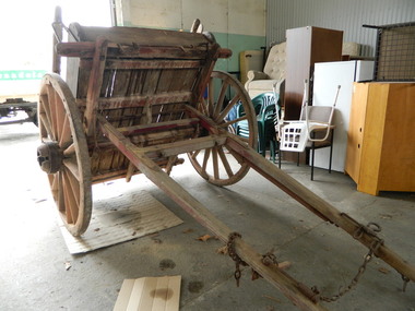
Tipping Dray
The dray was pulled by a horse and used to transport road building materials such as gravel. The tray carried 0.7 of a cubic metre which would have weighed about 1 tonne (varying on the load being wet or dry).This tipping dray was owned by John Briggs who carried gravel on the Tawonga to German Creek Road from 1894 to 1895. Workers were paid 2/- (shillings) per day to cover sections that were called 'a paddock' resulting in workers finishing at 10 or 11 pm. The road opened on the 17th March 1896 at a cost of 1700 pounds. See KVHS 0960 for newspaper article re Tom Briggs and making (and photo) of the Tawonga Gap road.Old single axil wooden dray with wooden spoke wheels and a tipping wooden tray.tipping dray. john briggs. tawonga. german creek. road building. transport. -
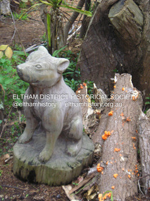
 Eltham District Historical Society Inc
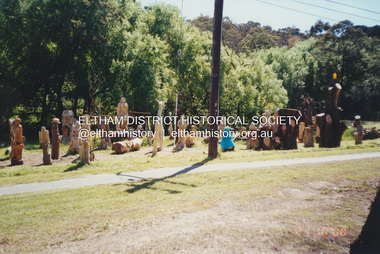
Photograph, Fay Bridge, Leigh Conkie's chainsaw sculptures, Main Road, Eltham, 21 October 2000
These chainsaw sculptures were created by Leigh Conkie at his home in Main Road. There were so many at times it would be a regular sight to see them sprawled across the public reserve adjacent to his home.fay bridge collection, 1305 main road, 2000-10-21, chainsaw sculpture, eltham, leigh conkie, main road -
 Eltham District Historical Society Inc
Photograph, Fay Bridge, Leigh Conkie's chainsaw sculptures, Main Road, Eltham, n.d
These chainsaw sculptures were created by Leigh Conkie at his home in Main Road. There were so many at times it would be a regular sight to see them sprawled across the public reserve adjacent to his home.fay bridge collection, 1305 main road, chainsaw sculpture, eltham, leigh conkie, main road -
 Eltham District Historical Society Inc
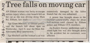
Document - Property Binder, 606 Main Road, Eltham
Newspaper article: Tree falls on moving car, Diamond Valley News, 15 April 1998, tree fell near Main Road and Antoinette Boulevard intersection, damaging car, power line and street light.main road, accident, eltham (vic) -
Glen Eira Historical Society
Newspaper - Melbourne Grammar School
A newspaper advertisement from the South Edition of the Leader News Dux 2010 promoting an education at Melbourne Grammar School and inviting tours of the school. Includes handwritten notes, Grimwade House, 67 Balaclava Road, Caulfield.melbourne grammar school, balaclava road, education, anglican school, grimwade house, caulfield -
Glen Eira Historical Society
Article - Eggleston, Frederic William
Photocopied article about Frederic William Eggleston from the 1934 Centenary Edition of 500 Victorians. He was a leading barrister, solicitor and author who lived at 164 Orrong Road, Caulfield. Cartoon with photographic face.eggleston frederic william, swinbourne george, caulfield, orrong road, barrister, solicitor, wesley college -
Glen Eira Historical Society
Document - Tucker Road, 240, McKinnon
A photocopy of undated research notes by Hilary Bullock f Brighton Historical Society describing the history of the property at 240 Tucker Road, McKinnon includes a brief history of the area and a list of the tenants from 1880 to 1955.tucker road, mckinnon, masters william h., manchester road, north road, draper thomas t., masters w. h. and co., electrical apparatus, market gardeners, market gardens, mcdonald henry, hewton d.r., church of england centre road, centre road, marquis leslie, monger arthur, devereaux john, priddeth charles, ianson h., chinese community, andrews james h., builders, land subdivisions, manufacturing industry, telegraph, telephones