Showing 3970 items matching "one handed"
-
 Eltham District Historical Society Inc
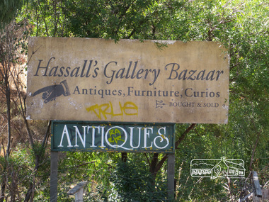
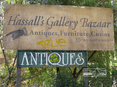
Photograph, Liz Pidgeon, Hassall's Gallery Bazaar, 1215 Main Road, Eltham, 25 March 2014, 25 March 2014
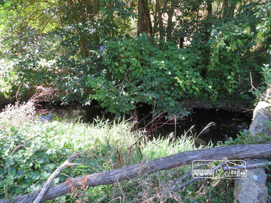
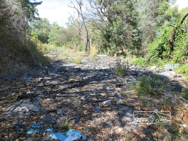
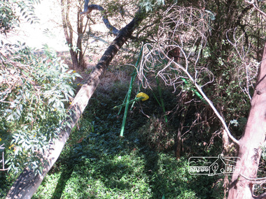
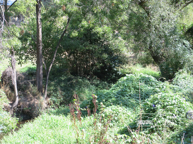
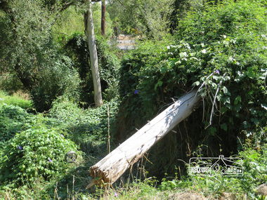
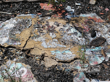
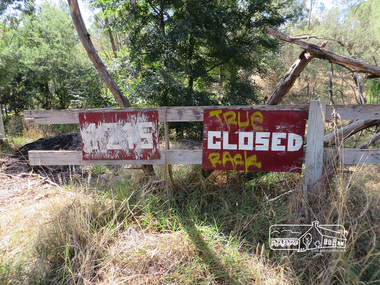
This is the site of the first roadside art gallery - Hassall's Roadside Gallery created by the artist son of an artist. Ian Hassall was the son of John Hassall who was among and may have been the first of the British poster artists. The gallery opened Saturday July 14, 1962 at 1215 Main road, Eltham by the director of the National Gallery of Victoria, Eric Westbrook. Situated on the left hand side of the main road, about a mile and a half beyond Eltham, towards Research, near Coleman's Corner at the intersection of Wattletree Road. The property has remnants of a stone quarry, probably for the purpose of gaining stone for local road making. Paintings were hung on screens and removed at night for safety. Large pedestals displayed sculpture and jewellery. All types of hand made art work was displayed. Access to the exhibition and grounds was slightly lower than the level of the road. They were encircled by a narrow little moat formed by a small tributary of the Diamond Creek accessed by a small well built stone bridge built by Ian Hassall with local stone. The Gallery later became known as Hassall's Gallery Bazaar antiques, furniture, curios bought and sold. It operated through to the early 1990s. The property has been derelict and neglected for some years. At one stage a shipping container sat near the entrance. This series of ten photographs illustrate the extent of the vegetation which has taken over the land, evidence of rubbish and a possible fire. In July 2017, planning permission was sought from the Shire of Nillumbik for buildings and works to construct a dwelling and associated vegetation removal. (source planningalerts.org.au)Born Digitaleltham, main road, hassall's gallery bazaar -
 Eltham District Historical Society Inc
Photograph, Liz Pidgeon, Hassall's Gallery Bazaar, 1215 Main Road, Eltham, 25 March 2014, 25 March 2014
This is the site of the first roadside art gallery - Hassall's Roadside Gallery created by the artist son of an artist. Ian Hassall was the son of John Hassall who was among and may have been the first of the British poster artists. The gallery opened Saturday July 14, 1962 at 1215 Main road, Eltham by the director of the National Gallery of Victoria, Eric Westbrook. Situated on the left hand side of the main road, about a mile and a half beyond Eltham, towards Research, near Coleman's Corner at the intersection of Wattletree Road. The property has remnants of a stone quarry, probably for the purpose of gaining stone for local road making. Paintings were hung on screens and removed at night for safety. Large pedestals displayed sculpture and jewellery. All types of hand made art work was displayed. Access to the exhibition and grounds was slightly lower than the level of the road. They were encircled by a narrow little moat formed by a small tributary of the Diamond Creek accessed by a small well built stone bridge built by Ian Hassall with local stone. The Gallery later became known as Hassall's Gallery Bazaar antiques, furniture, curios bought and sold. It operated through to the early 1990s. The property has been derelict and neglected for some years. At one stage a shipping container sat near the entrance. This series of ten photographs illustrate the extent of the vegetation which has taken over the land, evidence of rubbish and a possible fire. In July 2017, planning permission was sought from the Shire of Nillumbik for buildings and works to construct a dwelling and associated vegetation removal. (source planningalerts.org.au)Born Digitaleltham, main road, hassall's gallery bazaar -
 Eltham District Historical Society Inc
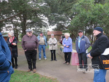
Photograph, Shire of Nillumbik World War One Memorials tour, 10 August 2016, 10 August 2016
As part of a program to acknowledge the Anzac Centenary Nillumbik Shire Council partnered with Yarra Plenty Regional Library to provide a bus tour with commentary of local sites of significance. These included Eltham township, the Shire of Eltham War Memorial at Kangaroo Ground, Christmas Hills, Hurstbridge memorial recreation park and finished at Eltham Library to view the Writing the War exhibtion at Eltham Library Community Gallery. Dennis Ward (right hand side) of "The Friends of Kangaroo Tower" gives a brief presentation about the site. Born Digitalworld war 1, war memorials, shire of nillumbik, kangaroo ground, kangaroo ground memorial, tour, dennis ward -
 Kiewa Valley Historical Society
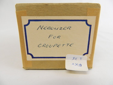
Nebulizer - Medical
This medical / hospital instrument was used in the Tawonga District General Hospital which was built in the 1950's specifically for the increase in population due to the Kiewa Hydro Scheme. Previous UKV 325Historical: Shows the development of scientific hospital equipment. Provenance: Used in the Tawonga District General Hospital which was remote and therefore required good equipment. Good condition and good interpretation capacity.Brown cardboard box containing 3 clear glass instruments. Two have a sphere in the middle with a long thin hollow cylinder at one end and a similar one at the other end except this one continues into the sphere and ends in a hook. The other instrument consists of a hollow cylinder that curves at the bottom and goes into a hollow ball. The ball has one small hollow appendage coming out at an angle and another short wide round hollow cylinder at its top. Label at end of box hand written: "Used for croupette"Box label: 'Nebulizer for Croupette"nebulizer, medical, hospital, croupette, tawonga district hospital -
 Kiewa Valley Historical Society
Ear Syringe - Medical
This medical / hospital instrument was used in the Tawonga District General Hospital which was built in the 1950's specifically for the increase in population due to the Kiewa Hydro Scheme.Historical: Shows the development of scientific hospital equipment. Provenance: Used in the Tawonga District General Hospital which was remote and therefore required good equipment. Good condition and good interpretation capacityA clear plastic bag with 1. Stainless steel syringe (cylinder) with 2 rings at one end and a small opening at the other. 2. a 3 pronged instrument 2 prongs are handles that squeeze together - the third is curved and attached to one side of the handle. 3. golden coloured curved instrument in the shape of a hollow rectangle with thin attachments at each end. The plastic bag has 'Broken' hand written in red at the top.ear syringe, medical, hospital, tawonga district hospital -
 Kiewa Valley Historical Society
Baby's Bonnet
This bonnet could have been part of a Christening outfit which matches the same style of "KVHS 0235" The quality of the garment and the fashion style it represents is both historical, and is of the fashion in that era. It has Christian religious implications and values of the time frame of regional life in the early 1900s. It is hand made possibly by the mother of the child being christened. The bonnet was probably worn at a christening in one of the Kiewa Valley churches (denomination unknown). The importance of the event to family and friends is shown by the quality of the garment. These style Christening items were often worn buy several children of the one family , both boys and girls. Other items that match this outfit are KVHS 0235. White crocheted baby's bonnet threaded with white ribbon. (Possibly for christening.) infant. baby. bonnet. crochet. christening. -
 Kiewa Valley Historical Society
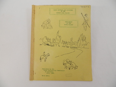
Book - Bogong High Plains x2, Early History and Discovery of the Bogong High Plains, 1968
The State Electricity Commission of Victoria constructed the Kiewa Hydro Electric Scheme in the north east of Victoria. Mr R.M. Duncan prepared the notes. He was a member of the S.E.C. Kiewa Branch from 1949 - 1966. This book was commissioned by the State Electricity Commission of Victoria. It consists of the early history of the Bogong High Plains and the origin of names of places and creeks in the area.This book was researched in 1968 by Mr R.M. Duncan who worked for the S.E.C. on the Kiewa Hydro Electric Scheme from 1949 to 1966. His sources were the Melbourne Public Library, the Victorian Historical Society, the North Eastern Victorian Historical Society and the Dept. of Crown Lands & Survey, Melbourne. The book is an accurate history of the Bogong High Plains given the available records at the time. Yellow cardboard covered book with black sketches and green print. 9 one-sided pages held together by 3 staples and taped over the staples. One - has sheets enclosed "The Three Floras of Bogong" and "General Geology of the Kiewa Area". 6 copies including 1 that is a photocopyDDTS hand written on front cover "Early History and Discovery / of the / Bogong High Plains" on cover top centre. "Settlement / of the / Kiewa-Valley" on cover towards the top slightly to the right. "Published by the / State Electricity Commission / of Victoria / July, 1968" on cover bottom left. "TR-K 596-4" on cover bottom left.bogong high plains. state electricity commission of victoria. kiewa. aborigines. kiewa valley. mullindollingong pastoral run. flora. geology -
 Kiewa Valley Historical Society
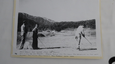
Photo - Golfers at Mt Beauty Golf Course
This photograph is one of the first photos of golfing in Mt Beauty. It is dated 1948 and it pictures three high-profile Kiewa Hydro Electric Scheme staff members having a hit of golf on a rudimentary course which was the fore runner to the beautiful golf course we enjoy today. This photo may have been published in one of the SECV magazines.Jack Giniff, Jack Ormerod and Lloyd Dunn were well known on the K.H.E.scheme. The photo shows how quickly community facilities were organised to provide sporting opportunities for the 4000+ workforce.Photo of 3 men playing golf copied from the original onto photo-quality paper in an enlarged form.Hand written at the bottom of the photo: "Mount Beauty Golf Course 1948 (7th Fairway). This is now the 2nd Fairway. Fairway Avenue will run along - the fenceline on the left. Players: Jack Giniff, Jack Ormerod, Lloyd Dunn." Note: "Jack Andrews" crossed out.golf at mt beauty, sport and recreation -
 Kiewa Valley Historical Society
Papers - Guides and Brownies, 1st Tawonga Guide Company and 1st Tawonga Brownie Pack
... 14 A4 pages stapled in the top left hand corner. Printed... Brownies 14 A4 pages stapled in the top left hand corner. Printed ...The written and illustrated history of Guides (11 to 14) and Brownies (7 to 10 year olds) in Tawonga commencing in 1951. Lord Baden-Powell first organized the groups for girls in c1914. It was to enable girls to be involved in scouting eg. camping, hiking and similar activities. Guides and Brownies were community organizations for the girls living in Tawonga from 1951. The organisations were based on scouting activities.14 A4 pages stapled in the top left hand corner. Printed on one side, including black and white photostawonga guides, tawonga brownies -
 Kiewa Valley Historical Society
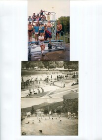
Photos - x 2 Mt Beauty Swimming Pool
The Mt Beauty swimming pool was first constructed in the early 1960s and opened on 7th January 1964. Currently the main pool is 'partially' heated and the area has a splash area for the children. Details of the time line and people involved are given on the typed sheets. See. "Below Bogong - A History of Mount Beauty" compiled by Di Edmondson. Chapter 9, Pages 295-296. The detail on the typed sheets gives in details the steps taken by the community to achieve the completion of the swimming pool. An example of the effort the community put in to achieve the construction of the town's swimming pool. This activity is of historic and social significance and can be compared with activities of today especially as Mt Beauty was built as a construction town for the Kiewa Hydro Electric Scheme and is now a small town with the added influence of tourism. Science has also had an impact over the years as pools can be heated according to demand and budget.Two black and white photos of people swimming in a pool and one coloured photo of people standing on a diving board. 6 typed pages of varying sizes stapled at the top right hand corner titled 'Off with the old and on with the new" - a history of the construction of the swimming pool. AM Collectionmt beauty swimming pool -
 Kiewa Valley Historical Society
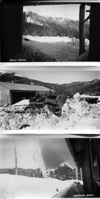
Photos - S.E.C. Work on Kiewa Hydro Electric Scheme
... in white on the bottom left hand corner. And one other photo... of Sawmill with titles in white on the bottom left hand corner ...B & W photos - x2 of Homans and x1 of Sawmill with titles in white on the bottom left hand corner. And one other photo of a building in snowHowmans Dam; Howmans Gap; Saw Mill -
 Kiewa Valley Historical Society
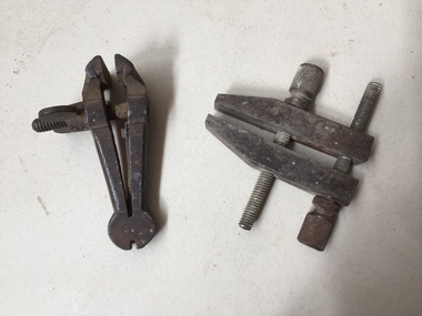
Tools - Vice and Clamp
Very old vice. The clamp is 50 to 60 years old when they were made by Technical School students in metal work class.Used by carpenters, woodworkers, furniture makers, welders, construction and metal workers in the Kiewa ValleyMathieson's Hand Vice, the smallest at 3 inches. Ref. Page 74 Tools for all Trades Catalogue. Small steel vice consisting of two parallel jaws for holding a workpiece. One jaw is fixed and the other movable by a screw. The clamp is used for holding a workpiece during hand operations eg. filing, hammering or sawing. Small steel clamp is a versatile tool that serves to temporarily hold work securely in place by screwing each jaw together.vice/vise tool, clamp tool, hand tools -
 Kiewa Valley Historical Society
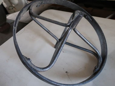
Steel Wheel of a wheel barrow
A wheelbarrow is a small hand-propelled load-bearing vehicle, usually with one wheel designed to be pushed and guided by a single person using 2 handles at the rear. It distributes the weight of its load between the wheel and the operator. Used by residents of the Kiewa Valley for construction and gardening.Formerly KV 067. A steel wheel made by a blacksmith.wheel, wheelbarrow, steel work -
 Kiewa Valley Historical Society
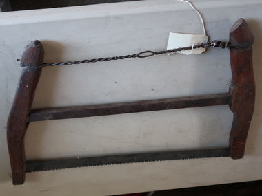
Buck Saw
A bucksaw is a hand powered frame saw similar to bow saw and generally used with a sawbuck to cut logs or firewood to length (bucking).Used by residents of the Kiewa Valley for clearing land, chopping firewood, cutting lumber. Also used while camping because it is portableFormerly UKV 239. Buck Saw with Lightning Tooth Blade. Operated by two men.Ref. Page 10 Tools for all Trade Catalogue. It consists of 3 horizontal bars, the top one being twisted wire and the bottom one being the metal blade with a wood bar in between. They are attached at each end to curved wooden bars. tool for wood, saw, buck saw -
 Kiewa Valley Historical Society
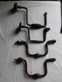
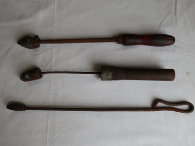
Braces for Hand Drilling x4
Very old. Ref. Pages 6 and 7 Tools for all Trades Catalogue. The braces vary in quality (strength) depending on what materials are used to make them.The brace is a hand operated tool for boring holes in wood, consisting of a crank-shaped turning device. The brace that grips and rotates the hole-cutting tool, the bit.Used by woodworkers in the Kiewa Valley.Vintage hand drill braces. All different and not all complete. Made of cast iron, steel with wooden handles. The drills fit into one end of the brace which is turned to make a drilling motion. A brace is a hand tool used with a bit (drill bit or auger) to drill holes, usually in wood. Pressure is applied to the top while the handle is rotated.brace and bit, woodwork, hand drilling -
 Kiewa Valley Historical Society
Soldering Irons x3
A soldering iron is a hand tool used in soldering. It supplies heat to melt solder so that it can flow into the joint between two workpieces. The iron was heated over a fire or in a charcoal brazier. Soldering irons were primarily used by tinsmiths and coppersmiths to work with thin sheet metal. These hand soldering irons have been replaced by electric ones.Used by coppersmiths and tinsmiths and workers in the Kiewa Valley.The soldering irons have a wooden handle, an iron rod and are made of copper at the pointy end (the bit).shaped like a pyramid.soldering iron, hand tool, coppersmith, tinsmith -
 Kiewa Valley Historical Society
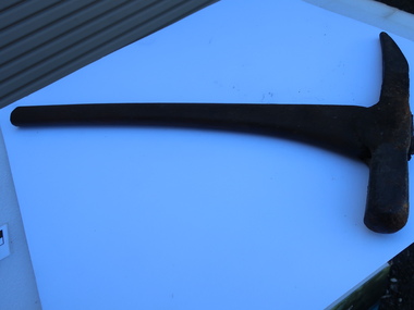
Miners Pick - short
Formerly KV 071. It was used to break up rock and ore, making it easier to extract valuable minerals. The pointed end of the pick axe was used to chip away rock, while the flat end was used to strike the rock for breaking it apart. This one has a short handle. Miners picks were commonly used in the the 19th and early 20th centuries for extracting gold from underground mine tunnels.Used in the Kiewa Valley where prospecting for gold occurred.Formerly KV 071. Cast iron symmetrical pick tool on cast iron with a wooden handle. It has a pointed end and a flat end. It is 12 inches long.gold mining, miners' pick axe, hand tool -
 Kiewa Valley Historical Society
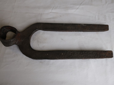
Double Tyne Pronged Pick - head
Possibly used for cleaning out animal pens.eg. horses and pigs. Used like a hoe but heavier and stronger.Used by residents of the Kiewa ValleyThick steel tool head with hole at one end for the handle and two parallel points. Possibly hand made.pick, double tyne prong pick, farming equipment, hand tool -
 Kiewa Valley Historical Society
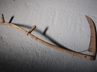
Scythe
Used as an agricultural hand tool for mowing grass or harvesting crops. It is historically used to cut down or reap edible grains, before the process of threshing. Replaced by horse drawn and then tractor machinery. Used by the early farmers in the Kiewa Valley.The steel blade is curved with a pointy end. It is attached to a long, slim wooden shaft with a slight S curve. It has 2 handles, one about half way along the shaft and another near the top both at right angles to the shaft. This results in the handles being on slightly different planes and makes it comfortable for the user when working. scythe, hand tool, mowing, harvesting -
 Kiewa Valley Historical Society
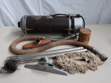
Vacuum Cleaner - Electrolux
Vacuum cleaners have been part of the household for many years. Beginning as simple tools blowing the dust to the current sucking up the dust and being powered by electricity. From the shape of a barrel to those that stand upright, from being fitted onto a 'sled' to those with wheels and from heavy to light.Used by a resident in the Kiewa Valley Electrolux cannister steel vacuum with leather handle at the top, the electric socket (and cut power cord attached) at one end and the cloth covered hose at the other end. Two steel extension handles, hose and cord works. Parts with combination dusting and upholstery tool and hardwood floor dust mop and refrigerator crevice tool. The cannister sits on a 'sled' of two long rods on each side.Hand written on the cannister "1932 Model" "Electro / lux / Made in Sweden / Design Nr B156 Registered" on top On bottom "Ser 1234 No. 1456 / Volt Watt" ....(not legible)electrolux, vacuum cleaner 1932 -
 4th/19th Prince of Wales's Light Horse Regiment Unit History Room
Postcard Booklet, Views of Ypres
A paper covered booklet of post cards showing scenes of Ypres. Each card shows two scenes of the same subject, taken from approximately the same spot, one before and one after the bombardment of the town.The booklet originally contained 24 cards but one is missing. The front shows a floral scroll type image up the left hand side and across the top, with VUES D'YPRES, Views of Ypres written underneath, with 24 Cartes Postales. Collection ANTONY-YPRES. Passed by Censor (Copyright)ypres, photos -
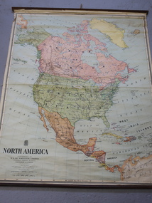 Kiewa Valley Historical Society
Maps - Educational x 10 and Kiewa Scheme x1
Maps were used to teach children geography, the explorers, the minerals, the world etc. The school bought and stored the maps so that they were available for use. This predated electronic devices. The KHE Works map was hand drawn showing lots of detail.These maps were used by the Bogong Primary School. The Kiewa Hydro Electric Works was built by the SECV and produced hydro power. This map may have been used by pupils as well as workers on the Works. Large coloured maps on canvas, with a wooden beam along the top and bottom. Each one has a cord attached to the top so that the map may be hung up on a wall. Some are made by Chas. H. Scally & Co., Baronia Ave., Wollstonecraft, N.S.W. The Kiewa Hydro Electric Works map is pinkish and shows Rocky Valley Dam, Lake Guy and Mt Beauty pondage in dark blue.maps, educational maps, geography, primary school, kiewa hydro electric works