Showing 112701 items
matching tracks/roads
-
 Poowong Historical Group
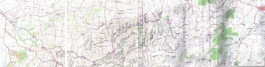
McDonald's Track Trek 5 April 2010 File, McDonald's Track
4 page overview of the McDonald's Track Trek 5 April 2010. Includes a map and an historical description of the track construction and the Trek notes by Rex Motton. -
 Marysville & District Historical Society
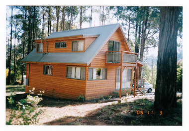
Photograph (Item) - Colour photograph, 11-03-2006
A colour photograph of a house taken in Kings Road in Marysville in Victoria.A colour photograph of a house taken in Kings Road in Marysville in Victoria. This house, along with most of Marysville's buildings, was destroyed in the 2009 Black Saturday bushfires.kings road, marysville, victoria, photograph, 2009 black saturday bushfires -
 Whitehorse Historical Society Inc.
Article, Livingstone School Has Schedule, 21/10/1976 12:00:00 AM
Plans for the new Primary SchoolPlans for the new Primary School in Livingstone Road, Vermont South, due to open in 1978, on display.Plans for the new Primary Schoolprimary schools, walton, trevor, vermont south primary school -
Whitehorse Historical Society Inc.
Map, Map of Mitcham, 1916?
Copy of early map of Mitcham.Copy of early map of Mitcham showing main roads and large blocks of land with owners' namesCopy of early map of Mitcham. mitcham road mitcham, heatherdale road mitcham, whitehorse road mitcham, morton, william, ainger, f, morgan, r. r., harding, w, sergeant, r, mcclelland, john, wilson, w, cook, j -
 Whitehorse Historical Society Inc.
Photograph - Black and white photograph, Williams Road Blackburn circa 1924. Electricity poles showing and unmade road
Williams Road Blackburn. Two early photos in black and white.Two early black and white photographs of Williams Road Blackburn prior to lots being sold.blackburn, williams road, 1924 -
 City of Moorabbin Historical Society (Operating the Box Cottage Museum)
Photograph - Plateway (Wheelway) Steel, circa 1885
... roads ...By the later 1800s the dirt roads in the then out-lying areas of the City of Moorabbin became dangerous, and almost impassable due to huge potholes and muddy swampy areas. The heavily laden market gardener’s carts regularly broke axles and wheels, and horses foundered on their way to the Melbourne markets. Even worse, the heavier “iron maidens”, carrying their malodorous loads of sewage from Melbourne’s inner suburbs for dumping in the outlying areas of the City of Moorabbin, also got bogged in the mire. It was decided that a practical solution to this problem was to install a metal plateway on the side of the problematic roads. In about 1887 the Moorabbin Shire Centre Road, in the Brighton East area, two parallel metal rails were installed so that the wheels of carts could run along smoothly, the horse travelled in the filled, middle area between the rails. Point Nepean Road plateway was removed in 1930 and Centre Dandenong Road plateway was removed in 1934-35. The worn plateway along Centre Road, East Brighton (now known as Bentleigh), was gradually taken up in several pieces, commencing in the the1920s, when its condition deteriorated and it caused a hazard to bikes, pedestrians, motor-cycles and the few early cars. The early steel plateway, constructed by David Munro, and opened on 23rd March 1885 by Thomas Bent, was built along Nepean Highway, between Asling St. and Bay St. The Point Nepean Track was subsequently extended into Moorabbin with branches along Centre, Cumins, South, Wickham, and Keys Roads, the total length was 13 miles. In 1908-1909 plates were laid along Centre Dandenong Road to Ross Street Bentleigh This innovative solution proved successful and was used until gradually the main roads were upgraded, and motorised vehicles started to appear. Two parallel metal rails were installed in the right hand side of a few main roads in the Shire of Moorabbin so that the wheels of heavily-loaded market gardener's carts on their way to markets in Melbourne could run along smoothly. The horse pulling the carts travelled in the filled, middle area between the rails. The Steel Plateway was constructed by David Munro, and opened on 23rd March 1885 by Thomas Bent. The wheelway first only ran along Nepean Highway, but it soon extended from Centre Dandenong Road, along Nepean road to its junction with Chapel Street, St Kilda. Later branch lines were built along Centre Road, Bentleigh as far as Warrigal Road and, according to early photographs, along Wickham Road Moorabbin as well. This innovative solution proved successful and was used until gradually the main roads were upgraded, and motorised vehicles started to appear. There was a problem with the wheelway : there was only a single set of rails and this was established on the right-hand side of the Nepean Road, travelling towards the city. Traffic FROM the city travelled on the correct or left-hand side of the road. The exception to this rule was the malodorous iron-clads, heavily riveted iron carts, generally travelling in convoy, carrying several tons of human effluent out of Melbourne to be trenched-in in the sandy soil of the Moorabbin district. Moorabbin City Council donated and installed a small section of Plateway at Box Cottage Museum in 1984melbourne, brighton, moorabbin, roads, plateway, wheelway, transport, st kilda, bent thomas, munro david, market gardens, steelway, carts horse-drawn, iron maidens, point nepean track -
 Whitehorse Historical Society Inc.
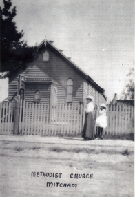
Photograph, Methodist Church - Mitcham
In 1887, land on the south east corner of Whitehorse Road and Richards Street, Mitcham was purchased and in 1888 a weatherboard church was erected. This early church was used until 1921, when the building was moved to a site in Mitcham Road, just north of Whitehorse Road. The church was enlarged and re-opened in 1921Black and white photograph of the Mitcham Methodist Church which was erected in 1888, on the corner of Whitehorse Road and Richard Street, Mitchammethodist church, mitcham -
 Melbourne Tram Museum
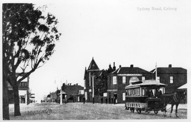
Photograph - Black and White Coburg Horse Tram - Sydney Road and Bell St
Photograph shows a north bound horse tram drawn by a single horse at the corner of Sydney Road and Bell St. This tramline was operated by the Northern Tramway Co. from 1889 to 1915 when it was closed and the line electrified by the Melbourne Brunswick and Coburg Tramways Trust to build their lines. See reference for an extensive history of this horse tram line.Yields information about the Coburg horse tram and the streetscape. Black and White photograph of a horse tram at the corner of Bell St and Sydney Road. Photo has the title of "Sydney Road Coburg"northern tramway co, horse trams, coburg, bell st, sydney road, bell street, trams, tramways -
 Phillip Island and District Historical Society Inc.
Photograph, 1978/79
W Reid, a cousin of O Underdown and descendant of Captain David Reid, lived here in Reid Road, Rhyll.Coloured photograph of family home of late W Reid, Reid Road, Rhylllocal history, photographs, buildings - historical, coloured photograph, john cook, phillip island, w reid -
 Ballarat Tramway Museum
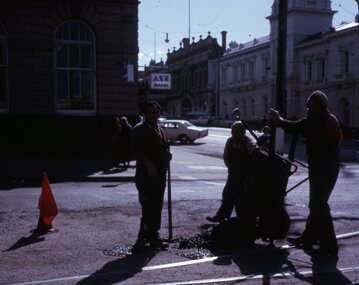
Slide - 27 mm sq slide/s - set of 2 - track workers, Lilian Butler, August or September 1971
Yields information about SEC road workers repairing the bitumen or road surface in Ballarat.Set of two Colour 27 x 27 mm slides in a Kodachrome cardboard mount: .1 - Group of three SEC road repairer or track workers repairing the road surface the intersection of Sturt and Lydiard St with new asphalt mix. shows the red flag on the right - Sept. 1971 .2 - Group of three SEC road repairers, laying asphalt in Wendouree Parade, with the Road Roller and the concrete tram shelter at Forest St. in the background. - August 1971 Photo from the collection of Lilian Butler.ballarat, tramways, trams, trackwork, road works, sturt st, lydiard st north, wendouree parade, road roller, jelbart, shelters, forest st -
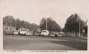 Melbourne Tram Museum
Postcard, Rose Stereograph Co, "St Kilda Road, from Princes Bridge Melbourne Vic", c1950
Postcard - Black and White - Rose Series P13352, titled "St Kilda Road, from Princes Bridge Melbourne Vic", featuring a traffic in St Kilda Road, all stopped (by a traffic policeman) at the intersection with City Road - has 7 motor vehicles all neatly stopped in a line and two tramcars (W2). Includes three black and white taxis - tow of the FJ Holden type. The City Road tram tracks are in the foreground. On the rear - has a divided back, and "A Real Photograph" " & Produced in Australia".On the rear has the stamp of Graeme S Breydon - see image i2.trams, tramways, melbourne, princes bridge, st kilda rd, city rd -
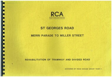 Melbourne Tram Museum
Drawing, Road Construction Authority(RCA), "St Georges Road - Merri Parade to Miller St - Rehabilitation of Tramway and Divided Road", Dec. 1988
Set of two comb bound drawings for the "St Georges Road - Merri Parade to Miller St - Rehabilitation of Tramway and Divided Road", stippled card covers, providing details of plans, drainage, cross sections, track locations for the reconstruction of the roadway. Prepared Dec. 1988, used 1989. 621.2 Second volume titled "Amended Cross Sections" Prepared by the Road Construction Authority - RCA - Road Design Group Team 2. See Reg item 2653 for reports prior to the work being undertaken.trams, tramways, st georges rd, thornbury, northcote, tramways, road works, construction -
 Royal District Nursing Service (now known as Bolton Clarke)
Photograph - Photograph, black and white, 23.05.1967
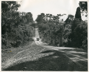
This photograph shows the typical road conditions encountered by RDNS District Sisters during their days work visiting patients to administer nursing care. From its inception in 1885 their Trained nurses (Nurses) of the then named Melbourne District Nursing Society (MDNS), later named Royal District Nursing Service (RDNS) gave high quality nursing care to patients in their own homes. They nursed patients referred by Hospitals and General Practitioners giving treatments, such as injections, wound care and doing other procedures, as well as assisting them with general care when required. District Nursing has had various modes of transport over the last 130 plus years. At first, from 1885 as MDNS, the Nurses walked the streets and lane ways amid the slums of central Melbourne. As the Society expanded public transport was used; bicycles were bought by the Society in 1903 and used in inner areas until 1945. During the Spanish flu epidemic, in 1919, MDNS appealed for assistance to procure Motor vehicles so the Nurses could visit an influx of cases. Through trusts, grants and donations four 'Ford 'T Model' cars were procured which enabled the Nurses to triple their visits. Through constant use the cars were in such a poor state they were sold in 1927. A Motor Auxiliary was formed in 1929 to take their Trained nurses (Sisters) to patients, and some Sisters used their own cars; even a motorcycle was used by one Sister in 1933. All these forms of transport were intermingled until, having received Royal patronage; the now Royal District Nursing Service (RDNS) had its own full fleet of vehicles by the mid 1960s. In many areas there were unsealed roads, in various conditions, which the Sisters negotiated to reach their patients to give care. By 2009 there were 598 cars in the fleet and the nurses travelled 9 million 200,000 kilometres – this is equivalent to 12 trips to the moon and back. In the centre of this black and white photograph is a Royal District Nursing Service, (RDNS) Sister in her RDNS grey car driving up the lower section of a hill on a dirt road. The car's rear black Victorian number plate, with 'JPH - 516' written on it can be seen. Dust is rising on either side of the car. In the foreground the road runs downward to a dip and then up the hill; trees are along either side of the road, and dirt and stones are seen on the side of the road in the left foreground. Photographers stamp. Quote No. GE 95rdns, royal district nursing service, rdns transport -
 Eltham District Historical Society Inc
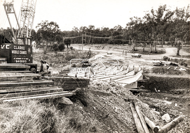
Photograph, Construction of new bridge over the Plenty River, Main Road, Lower Plenty, c.Aug. 1966
Construction of the Main Road bridge over the Plenty River. Includes structural members, construction personnel, vehicles and a Clarke mobile crane.Local significanceBlack and white printMarking on back of photograph - Plenty River Bridge Main Road 1969 (sic)lower plenty, main road, plenty river, bridge, bridge construction, civil engineering, cranes, mobile cranes -
 Ballarat Tramway Museum
Photograph - Colour Print/s, c1979
Yields information the construction of the depot fan extensions for four and five roads and has a strong association with the workers in the photograph.Colour print of Dave Macartney raking ballast on the extension of track for four and five roads, c 1979. Three road extension pig sty ski jump can be seen in the background. (Note photo of the same type as Reg item 4679 and 4680) 1979 - 1980 Annual Report shows a photograph on the front cover of the trackwork nearing completion.trams, tramways, depot construction, btps, trackwork -
 Melbourne Tram Museum
Photograph - Digital Image, Public Transport Victoria (PTV), "St Kilda Road and High Street - Buses replace trams - Sunday 13 Oct. to Sunday 27 Oct.", Oct. 2019
.1 - Pamphlet - 2 x 3 fold x titled "St Kilda Road and High Street - Buses replace trams - Sunday 13 Oct. to Sunday 27 Oct." 2019 for works at Domain, Park and St Kilda Road and track relay in High Street between St Kilda Road and Williams Road. Gives alternative bus routes. Part of the work was for the construction of the Noise Box or acoustic shed over the future Anzac Station site - part of the Metro Tunnel Works and track relocation. See htd3930i2.pdf for a detailed description of the work from the Metro Tunnel authority - Rail Projects Vic. This file does not want to open properly using dbtext works, access directly. Image i3 - from tdu website https://tdu.to/m/262235/re-d2-5005-at-temporary-tram-termin-us-st-kilda-road, shows the works underway. Posted by Metro Tunnel on twitter today showing progress on relocating tram tracks at site of Anzac station. This will allow construction of the southern box of the station. Large file (~2.6MB and 4096x2733 pixels, but enables you to get "up close and personal".trams, tramways, park st, domain junction, metro tunnel, toorak rd, st kilda rd, tramway construction -
Stawell Historical Society Inc
Document - Report, Nicole Start, Conservation Status of Roadsides in the Shire of Stawell, 1991
Covers: Shire, roadsides, Assessment: Species, Flora, Grazing, Cropping, Gravel, Noxious weeds, Firebreaks, Road Design. With loos maps X 2 in back. Author Nicole StartPlastic Front Cover. Yellow Paper with Photo of a country road.Nicole Start Biological and Chemical Sciences Ballarat University Collage December 1991 -
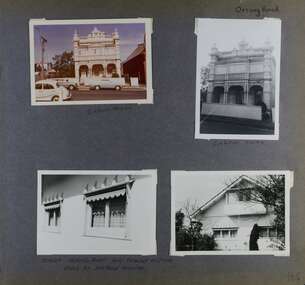 Glen Eira Historical Society
Album - Album page, Orrong Road, Circa 1972
This photograph is part of the Caulfield Historical Album 1972. This album was created in approximately 1972 as part of a project by the Caulfield Historical Society to assist in identifying buildings worthy of preservation. The album is related to a Survey the Caulfield Historical Society developed in collaboration with the National Trust of Australia (Victoria) and Caulfield City Council to identify historic buildings within the City of Caulfield that warranted the protection of a National Trust Classification. Principal photographer thought to be Trevor Hart, member of Caulfield Historical Society. Most photographs were taken between 1966-1972 with a small number of photographs being older and from unknown sources. All photographs are black and white except where stated, with 386 photographs over 198 pages.Victorian Heritage Database https://vhd.heritagecouncil.vic.gov.au/places/35576 No. 70 Orrong Road is important as an exceptionally ornate Boom style villa residence in the terraced form and in this respect is rare in Caulfield. Its architectural value is enhanced by its intact state and by the manner in which its bold architectural expression is carried through into the hallway and staircase. Victorian Heritage Database - National Trust local significance 284 Orrong Road Caulfield https://vhd.heritagecouncil.vic.gov.au/places/65700 A house designed by Harold Desbrowe Annear in 1917 and believed to have been the first "all electric" house in Melbourne. It has been extensively altered.Page 164 - four photographs of 2 different houses on Orrong Road. The top left photo is in colour while the others are in black and white.Handwritten: Orrong Road [top right] / Lisborn House [ (ed. correct name is LISBON HOUSE), under top left photo] / Lisborn House [under top right photo] / [under bottom right photo] / CORNER ORRONG ROAD AND PEARSON AVENUE / HOUSE BY DESBROWE ANNEAR [under bottom left photo] / 164 [bottom right]trevor hart, orrong road, lisbon house, lisborn house, elsternwick, pearson grove, st kilda east, caulfield north, terrace houses, cast iron work, verandahs, balconies, parapets, arches, cars, streetscapes, attic houses, desbrowe annear -
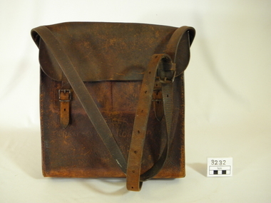 Lorne Historical Society
Functional object - Bag, circa1925
One of the toll bags used to collect tolls on the Great Ocean Road. First "Toll Gate" at Sunnymeade Estate as the road went through land owned by Mr C J Lane. Toll gates followed at "Stradbroke Point",later changed to "Stradbroke Knoll" named after the Govenor of Victoria, Lord Stradbroke, Grassy Creek and "The Springs". Mr W D McKay first toll keeper, then Mr & Mrs Wright. Toll commenced circa 1925 and ended 2nd October 1936. Cars were charged at 2/6 for car and driver and 1/- for each passenger. Motor cycles 2/-. Brown leather bag, with adjustable shoulder strap for carrying. Enclosed with a flap done up by 2 buckles.Hand scratched on front of bag:-"GREAT OCEAN ROAD TRUST".leather bag, toll gates, toll keepers, great ocen road -
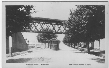 Melbourne Tram Museum
Photograph - Digital Image, Cheryl Grant, MMTB No. 121, outward bound in Norwood Road, 2012
Digital image of MMTB No. 121, outward bound in Norwood Road (Now Toorak Road), passing under the Alamein line rail over bridge mid 1920's. Note the single track in the street, which was not duplicated until Oct. 1927 (See Timeline history of Melbourne's Tramways). Real photo series Postcard No. 2358 and titled "Norwood Road Burwood" Note the tram has "18" under the bottom of the driver's dash.trams, tramways, burwood, toorak rd, norwood rd, railway bridge, alamein railway, tram 121 -
Phillip Island and District Historical Society Inc.
Publication, November, 1969
Produced and donated by Country Roads Board, 1969. Presented by Bill Papworth.Brochure produced by the Country roads Board for the Official Opening of the new bridge, November 21, 1969.local history, documents, publications, civil engineering, bridges, history of the phillip island bridge, phillip island bridges -
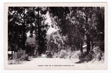 Marysville & District Historical Society
Postcard (item) - Black and white postcard, Murray Views, Murray Views No. 30. Road Scene, Marysville, Vic, Post 1929
An early black and white photograph of a road scene taken in Marysville, Victoria.An early black and white photograph of a road scene taken in Marysville, Victoria. This postcard was produced by Murray Views in Gympie, Queensland as a souvenir of Marysville."Kooringa"/ Monday Dear Mother/ Just a short note/ to say I am well & having a/ good holiday. Went on the/ Cumberland Valley trip last/ week - was very enjoyable./ To-day we are doing the Eildon/ Weir trip - all day. Have had/ fairly good weather - was able/ to go out every day. Will/ ring you later in the week/ about meeting me. If the/ strike is still on will probably/ get you to order a taxi for/ me. Lots of love/ Margaretmarysville, victoria, postcard, murray views, souvenir -
 Lakes Entrance Historical Society
Photograph - Keith Graham of Woodsedge Gallery, Lakes Post Newspaper, 1/06/1994 12:00:00 AM
Keith Graham of Woodsedge Gallery Baades Road Lakes Entrance VictoriaBlack and white photograph of Keith Graham of Woodsedge Gallery Baades Road Lakes Entrance Victoriaarts, exhibition -
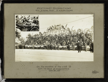 Kew Historical Society Inc
Photograph, The Sears Studio, Centenary Celebrations : Kew "Strong Post" St Kilda Road, 1934
Cr. W.D. Vaughan in 'Kew's Civic History' (1960) records that: "In connection with the Melbourne Centenary Celebrations in 1934, the Kew Council decided to organise a strong post as an appropriate gesture of welcome to H.R.H. the Duke of Gloucester. Also that the municipality be represented by a symbolic floral float in the Royal pageant. This was a striking entry and won first prize, and evoked much comment on account of its originality and truly Australian motif." The photograph of the Kew Strong Post was once part of the Municipal Collection of the former City of Kew and was presented to the Kew Historical Society before the move from the Walpole Street (Kew) Town Hall to new Civic offices in Charles Street in 1971.Historic photograph of participation by the City of Kew in celebrations for a royal visitFramed and glazed photograph on its original inscribed mount and original frame of the Kew "Strong Post" in St Kilda Road on the occasion of the visit to Melbourne of the Duke of Gloucester. The photograph has two components, at the upper left is a photo of the royal carriage while the man photo shows the people of Kew on a decorated 'Strong Post' on St Kilda Road, along which the procession progressed. T"Centenary Celebrations / Kew "Strong Post" St Kilda Road / On the occasion of the visit of / H.R.H. The Duke of Gloucester / October 18th 1934."royal visits - melboure - 1934, duke of gloucester, kew (vic.) — municipal collection -
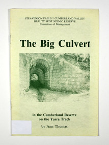 Marysville & District Historical Society
Booklet - Paperback booklet, Ann Thomas, The Big Culvert, 1992
A history of the Big Culvert in the Cumberland Reserve and its link to the Yarra Track.Paperback. Front cover has an old photograph of the big culvert.non-fictionA history of the Big Culvert in the Cumberland Reserve and its link to the Yarra Track.big culvert, cumberland reserve, yarra track, victoria, history -
 Melbourne Tram Museum
Photograph - Tram 678 crossing Geelong Road Footscray, Jim Seletto, c1960
The photograph shows an X2 class No. 678, north bound in Droop St Footscray, crossing Geelong Road with the destination of Ballarat Rd. Another tram can be seen southbound. Note the street fire alarm pillar on the right side of the photograph.Yields information about the trams in Droop St Footscray, c1960.Black and White photograph with photographer's notes on rear"678 Crossing Geelong Road" and "J Seletto photo" in ink.trams, footscray, x2 class, tram 678, droop st, geelong road -
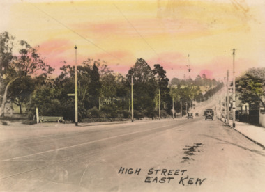 Kew Historical Society Inc
Postcard - High Street, East Kew, c.1927
High Street, Kew is the main Road in Kew. It was once also known as Bulleen Road, or Main Street. This section of the road is in Kew, although the narrow section on the right hand side of the photo is now Kew East. High Street progresses through a number of significant road junctions: beginning at Barkers Road; progressing through the intersection of Studley Park Road, Denmark Street and Princess Street at Kew Junction; branching left at the junction with Cotham Road; before reaching the junction with Valerie Street and Harp Road. It reaches its end at the junction of Burke Road, Kilby Road, Bulleen Road and High Street itself. An early photograph of this iconic Memorial that locates it in its context. Small, colorised real photo postcard of High Street, East Kew. Electric light poles line the road. Victoria Park is on the left and further on the horizon is the Boroondara General Cemetery.high street -- kew (vic.), victoria park, tram lines -- kew (vic.) -
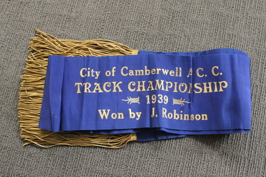 Camberwell Historical Society
Ceremonial object - Sash, City of Camberwell A.C.C. Track Championship cycling sash, 1939
Champion's sash from 1939 awarded to competitive cyclist Jack Stanley Robinson. Jack Stanley Robsinson lived in Canterbury for most of his youth and was a member of the City of Camberwell Amateur Cycling Club in the late 1930s. Jack appears in the press (NLA Trove) as a member of the Malvern cycling team in a March 1934 trial competition of “boys”, and then with increasing frequency in amateur competitions throughout 1935 to 1938. In October 1938 he appears in the Camberwell team. The last entry so far found is in December 1939, still with the Camberwell team. Blue sash with gold tassels 'City of Camberwell A.C.C. Track Championship 1939 Won by J. Robinson'cycling, sport -
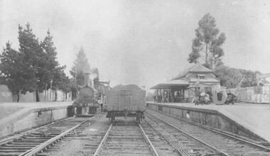 Ringwood and District Historical Society
Photograph, Ringwood Railway Station circa 1908
Black and white photograph {2 copies - 1 large, 1 smaller}Image shows steam train at platform with goods carriage on middle track -
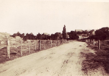 Clunes Museum
photograph, KODAK
VIEW OF GRAVEL ROAD FROM CLUNES TOWNSHIP TO STATION FLAT. LOWER PART OF PORT PHILLIP MINE ON LEFT OF PHOTO.VIEW OF ROAD LEADING TO STATION FLAT, CLUNES - ANGLICAN CHURCH ON HILL IN BACKGROUNDlocal history, clunes landscape.