Showing 18534 items matching "w"
-
 Clunes Museum
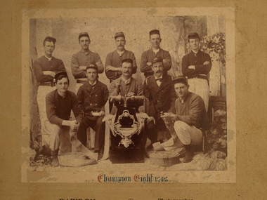
Photograph, CHAMPION EIGHT 1902, 1902
CLUNES FIRE BRIGADE WON THE CHAMPION EIGHT COMPETITION IN 1902. THEY WERE AWARDED A TROPY WHICH IS A FLUTED VASE ON A SILVER BASE WITH ORNATE FRAME HOLDING VAS AND TWO FLUTED TRUMPET VASES EITHER SIDE..1 COPY OF PHOTOGRAPH OF CLUNES FIRE BRIGADE CHAMPION EIGHT 1902 TEAM MEMBERS : W. POWER, B. HAWKS, M.C. CROWTHERS, G. PEARCE, ? MCKENZIE, F. MILES, G. HAY, ? MCKENZIE, P. KEMPSON, B. FEATONBY. .2 SEPIA COPY OF ABOVE, WITH INSCRIPTION ''CHAMPION EIGHT 1902'' .3 COPY OF SEPIA PHOTOGRAPH .4 ORIGINAL BLACK AND WHITE PHOTOGRAPH MOUNTED ON CARDBOARD .5 SEPIA COPY OF PHOTOGRAPH IN AN ORNATE WOODEN FRAME .4 CHAMPION EIGHT 1902 - BAWDEN PHOTOGRAPHER CLUNESlocal history, photography, fire brigade, trophy, champion eight, 1902 -
 Warrnambool and District Historical Society Inc.
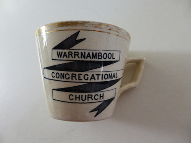
souvenir cup, Warrnambool Congregational Church
The Warrnambool Congregational Church was established with a meeting called in April 1862 and over the ensuing months a congregation with first pastor Rev W Pentland was established. After initially meeting at the small Temperence Hall in Liebig St, land was purchased at the corner of Liebig and lava St and the first church opened in March 1864. It remained on this site until the site was sold to the T & G Assurance in 1939 and land known as Kianga Estate was purchased on the corner of Lava and Henna Streets.It became part of the amalgamation with other churches to form the Uniting Church in 1977.This cup is possibly a souvenir from the 50th anniversary celebrations held in 1912. A common object which is linked to one of warrnambool's longest running churches.Cream china cup with thick gold rim and black test in banner style on one side of the cup. Warrnambool Congregational Church on front of cup . 338 written on bottom and 4 on paper labelwarrnambool, warrnambool congregational church -
 Eltham District Historical Society Inc
Photograph - Aerial Photograph, Landata, Eltham / Research, Vic, Jan. 1951
Centred on Brinkkotter Road opposite Yarramie Reserve, Eltham bounded by Maroondah Aqueduct to north, Nyora Road to south, Eltham College to east and Leane Drive to west. Historic Aerial Imagery Source: Landata.vic.gov.au Aerial Photo Details: Project No :65 Project : MELBOURNE AND METROPOLITAN PROJECT NO. 2 Run : 7 Frame : 8 Date : 01/1951 Film Type : B/W Camera : EAG9 Flying Height : 12200 Scale : 12000 Film Number : 1419 GDA2020 : 37°42'32"S, 145°10'41"E MGA2020 : 339408, 5824924 (55) Melways : 22 F3 (ed. 42)Historical aerial photos and photo maps provide viusal evidence of the chronology of changes to the built landscape of the district and assist in dating other imagesaerial photo, 1951-01, eltham, neil webster collection, brinkkotter road, eltham college, leane drive, maroondah aqueduct, melways 22f3, nyora road, yarramie reserve -
 Eltham District Historical Society Inc
Photograph - Aerial Photograph, Landata, Eltham, Vic, Jan. 1951
Centred on Beard Street between Main Road and Frank Street, Eltham bounded by Maroondah Aqueduct to north, Arthur Street to south, Maroong Drive to east and Catholic Ladies College to west. Historic Aerial Imagery Source: Landata.vic.gov.au Aerial Photo Details: Project No :65 Project : MELBOURNE AND METROPOLITAN PROJECT NO. 2 Run : 7 Frame : 9 Date : 01/1951 Film Type : B/W Camera : EAG9 Flying Height : 12200 Scale : 12000 Film Number : 1419 GDA2020 : 37°42'23"S, 145°09'39"E MGA2020 : 337874, 5825170 (55) Melways : 22 B3 (ed. 42)Historical aerial photos and photo maps provide viusal evidence of the chronology of changes to the built landscape of the district and assist in dating other imagesaerial photo, 1951-01, eltham, neil webster collection, arthur street, beard street, catholic ladies college, frank street, main road, maroondah aqueduct, maroong drive, melway 22b3, research (vic.) -
 Eltham District Historical Society Inc
Photograph - Aerial Photograph, Landata, Eltham North, Feb. 1956
Centred on present day 54 Kelway Crescent, Eltham North bounded by Glen Gully Road to north, Meruka Drive to south, Eltham College to east and Leach Street to west. Historic Aerial Imagery Source: Landata.vic.gov.au Aerial Photo Details: Project No :250 Project : MELBOURNE OUTER SUBURBS PROJECT Run : 17 Frame : 113 Date : 02/1956 Film Type : B/W Camera : EAG9 Flying Height : 10000 Scale : 12000 Film Number : 1176 GDA2020 : 37°42'16"S, 145°08'08"E MGA2020 : 335650, 5825336 (55) Melways : 21 G2 (ed. 42)aerial photo, 1956-02, eltham, eltham north, glen gully road, leach street, main road, melway 21g2, meruka drive, montmorency, neil webster collection -
 Eltham District Historical Society Inc
Photograph - Aerial Photograph, Landata, Montmorency, Feb. 1956
Centred on present day Tahlee Place Reserve and Sherbourne Preschool, Montmorency bounded by Progress Road to north, Withers Way to south, Main Road to east and Leach Street to west. Historic Aerial Imagery Source: Landata.vic.gov.au Aerial Photo Details: Project No :250 Project : MELBOURNE OUTER SUBURBS PROJECT Run : 17 Frame : 114 Date : 02/1956 Film Type : B/W Camera : EAG9 Flying Height : 10000 Scale : 12000 Film Number : 1176 GDA2020 : 37°42'50"S, 145°08'02"E MGA2020 : 335512, 5824286 (55) Melways : 21 F5 (ed. 42)aerial photo, 1956-02, neil webster collection, central park, eltham, leach street, main road, melway 21f5, montmorency, progress road, withers way, sherbourne preschool, tahlee place reserve -
 Eltham District Historical Society Inc
Photograph - Aerial Photograph, Landata, Lower Plenty, Feb. 1956
Centred on present day 217 Old Eltham Road, Lower Plenty bounded by Pitt Street to north, Yarra River to south, Main Road to east and Bonds Road to west. Historic Aerial Imagery Source: Landata.vic.gov.au Aerial Photo Details: Project No :250 Project : MELBOURNE OUTER SUBURBS PROJECT Run : 17 Frame : 116 Date : 02/1956 Film Type : B/W Camera : EAG9 Flying Height : 10000 Scale : 12000 Film Number : 1176 GDA2020 : 37°43'58"S, 145°07'49"E MGA2020 : 335237, 5822186 (55) Melways : 21 E10 (ed. 42)aerial photo, 1956-02, neil webster collection, eltham, main road, bonds road, elham, lower plenty, melway 21e10, pitt street, yarra river -
 Eltham District Historical Society Inc
Photograph - Aerial Photograph, Landata, Eltham, Feb. 1956
Centred on present day Shalbury Avenue, Eltham bounded by Leane Drive and Parsons Road to north, Nyora Road to south, Reynolds Road to east and the Diamond Creek to west Historic Aerial Imagery Source: Landata.vic.gov.au Aerial Photo Details: Project No :250 Project : MELBOURNE OUTER SUBURBS PROJECT Run : 18 Frame : 95 Date : 02/1956 Film Type : B/W Camera : EAG9 Flying Height : 10000 Scale : 12000 Film Number : 1176 GDA2020 : 37°41'57"S, 145°09'51"E MGA2020 : 338145, 5825965 (55) Melways : 22 C1 (ed. 42)aerial photo, 1956-02, neil webster collection, eltham, diamond creek (creek), melway 22c1, nyora road, parsons road, reynolds road, shalbury avenue -
 Eltham District Historical Society Inc
Photograph - Aerial Photograph, Landata, Research, Vic, Feb. 1956
Centred on present day Thompson Crescent, Research bounded by Maroondah Aqueduct to north, Thompson Crescent and Nyora Road to south, Bells Hill Road to east and Eucalyptus Road to west Historic Aerial Imagery Source: Landata.vic.gov.au Aerial Photo Details: Project No :250 Project : MELBOURNE OUTER SUBURBS PROJECT Run : 19 Frame : 6 Date : 02/1956 Film Type : B/W Camera : EAG9 Flying Height : 10000 Scale : 12000 Film Number : 1176 GDA2020 : 37°42'38"S, 145°11'02"E MGA2020 : 339927, 5824736 (55) Melways : 22 H4 (ed. 42)aerial photo, 1956-02, neil webster collection, bells hill road, eltham, eucalyptus road, maroondah aqueduct, melway 22h4, nyora road, research (vic.), thompson crescent -
 Eltham District Historical Society Inc
Photograph - Aerial Photograph, Landata, Research, Vic, Apr. 1963
Centred on present day Thompson Crescent and Nicholson Close, Research bounded by Maroondah Aqueduct to north, Nyora Road to south, Eltham College to east and Eltham Gateway Hotel to west. Historic Aerial Imagery Source: Landata.vic.gov.au Aerial Photo Details: Project No :486 Project : MELBOURNE (1963) PROJECT Run : 5 Frame : 61 Date : 04/1963 Film Type : B/W Camera : RC8 Flying Height : 5100 Scale : 9600 Film Number : 1805 GDA2020 : 37°42'24"S, 145°10'06"E MGA2020 : 338528, 5825143 (55) Melways : 22 D3 (ed. 42)aerial photo, neil webster collection, eltham, 1963-04, eltham college, eltham gateway hotel and conference centre, maroondah aqueduct, melway 22d3, nicholson close, nyora road, research (vic.), thompson crescent -
 Eltham District Historical Society Inc
Photograph - Aerial Photograph, Landata, Eltham, Vic, Apr. 1963
Centred on present day John Street, Eltham between Main and Bible streets bounded by Elsa Court to north, Main Road Bridge to south, Wattle Grove to east and Bolton Street to west. Historic Aerial Imagery Source: Landata.vic.gov.au Aerial Photo Details: Project No :486 Project : MELBOURNE (1963) PROJECT Run : 6 Frame : 123 Date : 04/1963 Film Type : B/W Camera : RC8 Flying Height : 5100 Scale : 9600 Film Number : 1805 GDA2020 : 37°43'12"S, 145°08'54"E MGA2020 : 336800, 5823623 (55) Melways : 21 J6 (ed. 42)aerial photo, neil webster collection, 1963-04, bolton steet, elsa court, eltham, john street, main road, main road bridge, melway 21j6, wattle grove -
 Eltham District Historical Society Inc
Photograph - Aerial Photograph, Landata, Eltham, Vic, Apr. 1963
Centred on present day Eltham Ridge, Bolton Street, Eltham bounded by Elsa Court to north, Main Road to south, Bible Street to east and Reichelt Avenue and Rattray Road to west. Historic Aerial Imagery Source: Landata.vic.gov.au Aerial Photo Details: Project No :486 Project : MELBOURNE (1963) PROJECT Run : 6 Frame : 124 Date : 04/1963 Film Type : B/W Camera : RC8 Flying Height : 5100 Scale : 9600 Film Number : 1805 GDA2020 : 37°43'12"S, 145°08'16"E MGA2020 : 335876, 5823604 (55) Melways : 21 G6 (ed. 42)aerial photo, neil webster collection, 1963-04, bible street, bolton street, eltham, eltham ridge, main road, montmorency, rattray road, reichelt avenue -
 Eltham District Historical Society Inc
Photograph - Aerial Photograph, Landata, Eltham, Vic, Apr. 1963
Centred on present day Griffith Park Road, Eltham bounded by Mount Pleasant Road to north, Yarra River and Templestowe to south, Main Road at Reynolds Road to east and Falkiner Street to west. Historic Aerial Imagery Source: Landata.vic.gov.au Aerial Photo Details: Project No :486 Project : MELBOURNE (1963) PROJECT Run : 7 Frame : 233 Date : 04/1963 Film Type : B/W Camera : RC8 Flying Height : 5100 Scale : 9600 Film Number : 1805 GDA2020 : 37°44'04"S, 145°09'10"E MGA2020 : 337237, 5822053 (55) Melways : 22 A10 (ed. 42)aerial photo, neil webster collection, 1963-04, eltham, falkiner street, griffith park road, melway 22a10, mount pleasant road, reynolds road, templestowe, yarra river -
 Eltham District Historical Society Inc
Photograph - Aerial Photograph, Landata, Eltham, Vic, Apr. 1972
Centred on present day Zig Zag Road near Coolabah Drive, Eltham bounded by Allendale Road to north, Park West Road to south, Parsons Road to east and Banks Road to west. Historic Aerial Imagery Source: Landata.vic.gov.au Aerial Photo Details: Project No :985 Project : MELBOURNE 1972 Run : 26 Frame : 191 Date : 04/1972 Film Type : B/W Camera : RC10 Flying Height : 5700 Scale : 9600 Film Number : 2636 GDA2020 : 37°41'56"S, 145°09'26"E MGA2020 : 337533, 5826000 (55) Melways : 22 A1 (ed. 42)aerial photo, neil webster collection, 1972-04, allendale road, eltham, eltham north, zig zag road, banks road, coolabah drive, melway 22a1, park west road, parsons road -
 Eltham District Historical Society Inc
Photograph - Aerial Photograph, Landata, Eltham, Vic, Apr. 1972
Centred on present day Parsons Road, Eltham bounded by Allendale Road to north, Frank Street to south, Research Shops and Raglan Road to east and Zig Zag Road to west. Historic Aerial Imagery Source: Landata.vic.gov.au Aerial Photo Details: Project No :985 Project : MELBOURNE 1972 Run : 26 Frame : 192 Date : 04/1972 Film Type : B/W Camera : RC10 Flying Height : 5700 Scale : 9600 Film Number : 2636 GDA2020 : 37°42'00"S, 145°09'59"E MGA2020 : 338360, 5825897 (55) Melways : 22 D1 (ed. 42)aerial photo, neil webster collection, 1972-04, allendale road, eltham, zig zag road, frank street, melway 22d1, parsons road, raglan road, research (vic.), research shops, eltham barrel -
 Eltham District Historical Society Inc
Photograph - Aerial Photograph, Landata, Eltham, Vic, Apr. 1972
Centred on present day Woodridge Estate, Eltham bounded by Park Road to north, Mount Pleasant Road to south, Stokes Orchard Estate to east and Eltham Railway Station to west. Historic Aerial Imagery Source: Landata.vic.gov.au Aerial Photo Details: Project No :985 Project : MELBOURNE 1972 Run : 27 Frame : 46 Date : 04/1972 Film Type : B/W Camera : RC10 Flying Height : 5700 Scale : 9600 Film Number : 2636 GDA2020 : 37°42'49"S, 145°09'46"E MGA2020 : 338053, 5824365 (55) Melways : 22 C5 (ed. 42)aerial photo, neil webster collection, 1972-04, eltham, eltham railway station, melway 22c5, mount pleasant road, park road, stokes orchard estate, woodridge estate -
 Eltham District Historical Society Inc
Photograph - Aerial Photograph, Landata, Eltham, Vic, Apr. 1972
Centred on present day Main Road at Pryor Street, Eltham bounded by Park West Road to north, Napoleon Street to south, Woodridge Estate to east and Ryans Road to west. Historic Aerial Imagery Source: Landata.vic.gov.au Aerial Photo Details: Project No :985 Project : MELBOURNE 1972 Run : 27 Frame : 47 Date : 04/1972 Film Type : B/W Camera : RC10 Flying Height : 5700 Scale : 9600 Film Number : 2636 GDA2020 : 37°42'45"S, 145°09'12"E MGA2020 : 337223, 5824470 (55) Melways : 22 A4 (ed. 42)aerial photo, neil webster collection, 1972-04, eltham, eltham railway station, woodridge estate, eltham shops, main road, melway 22a4, napoleon street, park west road, pryor street, ryans road -
 Eltham District Historical Society Inc
Photograph - Aerial Photograph, Landata, Eltham, Vic, Apr. 1972
Centred on present day Dalton Street at Mount Pleasant Road, Eltham bounded by Arthur Street to north, Yarra River and Kent Hughes Road to south, Eucalyptus Road to east and Susan Street to west. Historic Aerial Imagery Source: Landata.vic.gov.au Aerial Photo Details: Project No :985 Project : MELBOURNE 1972 Run : 28 Frame : 208 Date : 04/1972 Film Type : B/W Camera : RC10 Flying Height : 5700 Scale : 9600 Film Number : 2635 GDA2020 : 37°43'29"S, 145°08'54"E MGA2020 : 336816, 5823118 (55) Melways : 21 J8 (ed. 42)aerial photo, neil webster collection, 1972-04, eltham, arthur street, dalton street, eucalyptus road, kent hughes road, melway 21j8, mount pleasant road, susan street, yarra river -
 Eltham District Historical Society Inc
Document - Series Listing, Fraser Faithfull et al, Series 42: Community Arts - Slides & Negatives, 2000
I) Banner Project - 56 colour slides, 4 x 35mm colour negatives, I 5inch x 4inch transparency (of the banner "Education is child's play at Kindergarten" ). 2) Interaction of Young People with Community Arts - Treasure Trees, 90 colour negatives and 3 colour slides. 3) Lenister Farm Community Arts Office and Staff 1993, 25 colour negatives and 8 colour slides. 4) Community Arts and Engineering Project - Bus Shelter and Notice Board, Lower Eltham, designed by Glen Birrell (wearing yellow shirt in colour snapshots), 1993, 25 B&W negatives.shire of eltham archives, series listing -
 Ballarat Clarendon College
Trophy
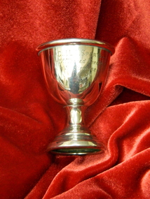
Nellie Price entered Clarendon Presbyterian Ladies College in 1920. Daughter of Mr E H Price of 'Dumbarton' Sturt St W; sister of John L, Elvina Coltman & E Morris. Nell was President of the CPLC Old Collegians Association 1941-42 and Secretary 1955-57. She married Robert Smail, uncle of Andrew Smail (1954). Robert's father built the original Enderly house in Sturt St. This trophy provides a significant glimpse of both the nature and importance of sports amongst school students in the 1920s. There is a comprehensive report of the 1924 Sports Day in The Touchstone December 1924 pp.11-14Tiny silver egg cup and stem with rolled top edge and engraving on face of cupEngraved on cup:C.P.L.C. SPORTS / Snr Thread Needle / Snr Siamese / N.P. / 1924nellie-price, nell-smail, sports, 1924, clarendon-presbyterian-ladies-college -
 4th/19th Prince of Wales's Light Horse Regiment Unit History Room
Poem, The Horses Stay Behind, 1919
During WW1 Australia sent 39,348 Walers overseas to the AIF. Many Light Horsemen enlisted with their horses with a government promise that they would be able to bring their horses home with them. On the outbreak of peace, costs became important and it was deemed too costly to have horses repatriated to Australia - except for one horse, "Sandy", owned by General W T Bridges who died at Gallipoli in 1915 Quarantine was offered as a reason for not permitting the walers to return to Australia. However, the horses would have had a long sea voyage, giving time for problems to emerge. Many of the fit horses were sold to the Indian ArmyFramed print of poem "The Horses Stay behind". In days to come we'll wander west and cross the range again; We'll hear the bush birds singing in the green trees after rain; We'll canter through the Mitchell grass and breast the bracing wind: But we'll have other horses. Our chargers stay behind. Around the fire at night we'll yarn about old Sinai; We'll fight our battles o'er again; and as the days go by There'll be old mates to greet us. The bush girls will be kind. Still our thoughts will often wander to the horses left. I don't think I could stand the thought of my old fancy hack Just crawling round old Cairo with a Gyppo on his back. Perhaps some English tourist out in Palestine may find My broken-hearted waler with a wooden plough behind. No; I'd better shoot him and tell a little lie: "He floundered in a wombat hole and then lay down to die" May be I'll be court-martialled; but I'm damned if I'm inclined To go back to Australia and leave my horse behind. Trooper Bluegum -
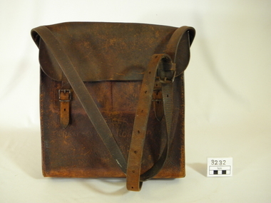 Lorne Historical Society
Functional object - Bag, circa1925
One of the toll bags used to collect tolls on the Great Ocean Road. First "Toll Gate" at Sunnymeade Estate as the road went through land owned by Mr C J Lane. Toll gates followed at "Stradbroke Point",later changed to "Stradbroke Knoll" named after the Govenor of Victoria, Lord Stradbroke, Grassy Creek and "The Springs". Mr W D McKay first toll keeper, then Mr & Mrs Wright. Toll commenced circa 1925 and ended 2nd October 1936. Cars were charged at 2/6 for car and driver and 1/- for each passenger. Motor cycles 2/-. Brown leather bag, with adjustable shoulder strap for carrying. Enclosed with a flap done up by 2 buckles.Hand scratched on front of bag:-"GREAT OCEAN ROAD TRUST".leather bag, toll gates, toll keepers, great ocen road -
 Ringwood and District Historical Society
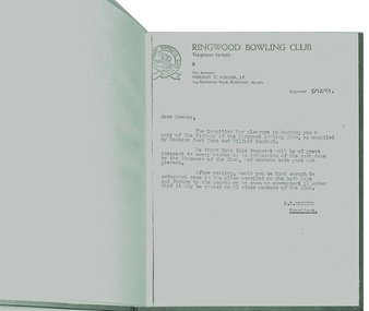
Book, Short History of Ringwood Bowling Club from 1929 -1961
The idea for a Bowling Club was started by Mr. Bert Cocks, the Manager of the State Savings Bank when he arrived in Ringwood in 1929 but it took two years before a suitable site and was found and in 1931 the club as formed. Ther were 57 foundation members. The President was Councillor Arthur Blood and W. Cox, Secretary. Ten months later the first Annual Report stated that " the green was ready for sowing, a Club House with a billiard table , donations of light fittings and furnishings by members and committee and a balance sheet showing assets over liabilities of £446,3,8." The book continues until 1961.It was compiled by Members Jack Knox and Wilfred Bamford.Plain green hard-covered book (untitled) with 25 typed pages. Letter to members inviting them to read the story and pass the book onto other members. Foreword by the President in 1961 -
Glen Eira Historical Society
Book - St. Clement’s Church of England, Elsternwick
2 copies of ‘Our First 100 Years Saint Clement's Elsternwick’, a 48 page book on the history of the church. Includes early photos of church, church members, interior of church, church furniture, nine stained glass windows and photographs of Rev. John Hislop, Rev. H. B. Macartney, Rev. H. W. H. Adeney, Rev. George Sproule, Rev. Hugh H. Gardner, Rev. Alfred Ernest Albert Britten, Rev. John Henry Frewin, Rev. Karl Egbert Hamilton, Rev. Colin J. Cohn, Rev. George Tooth, Rev. John Rowse. Includes photographs.st. clement’s church of england, st. clement’s anglican church, elsternwick, covey joan, moore alison, parkinson stephen, hislop john rev., allman beatrice, cohn colin, frewin nell, morris phyllis, hayman miriam e., kirke clarice, rowse john rev., tooth george rev., foundation stone, stanley st., manses, macartney h. b. rev., adeney h. w. h. rev, sproule george rev., oak avenue, gardner hugh h. rev., britten alfred ernest albert rev., frewin john henry rev., patterson nellie, moore mary elizabeth, hamilton karl egbert, hamilton mrs. karl, britten alfred mrs., cohn charlotte, cohn lottie, tooth brenda, stanley street, rowse kay, roselea street, caulfield south, anglican church, sunday schools, religious groups, clergy, davies j. h., mccombie street, caulfield grammar school, st. mary’s caulfield, carre-riddell t. w., stained glass, organs -
 Federation University Historical Collection
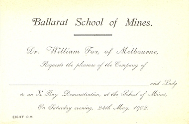
Document - Invitation and ticket, X-Ray Demonstration Invitation, 1902, 1902
The xray demonstration was given after the opening of the Mining at Metallurgical Laboratory at the Ballarat School of Mines. "Arrangements for the conversazione in Connection with the opening of the new metallurgical and mining laboratory at the School of Mines are in a forward state, and the inaugural ceremony pro mises to be a most auspicious one. Mr William Fox, of Melbourne, has accepted an invitation to be present, and he will give an X Ray demonstration. Dr Fox's achievements in this direction are well known, and the apparatus he is possessed of is very complete. During the evening Mr W. C. Little and Mr Bishop will give selections on the Pianola, and besides this there will be a first-class graphophone in operation." (Ballarat Star, 22 May 1902)Blue card with black printing.x-ray, ballarat school of mines, metallurgical laboratory, william fox, xray demonstration -
 Port Melbourne Historical & Preservation Society
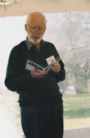
Photograph - Launch of History of a Street Precinct, 25 Sep
In 2005, members of the PMH&PS undertook a study of the residents of the houses in a Port Melbourne street precinct from the 1880s to 1960. The area is bounded by Evans Street, the E side of Bridge Street, S side of Williamstown Road, Farrell Street both the E & W sides plus the section of Ross Street between Farrell and Bridge and the part of Derham Street between Farrell and Bridge. The resulting map and an interactive CD won the Best Community Research, Registers & Records project at the 2007 Victorian Community History Awards. The project was launched on the railway reserve near the corner of Evans & Farrell streets. Co-author Graham BRIDE.Co-author, Graham Bride, at the launch of the History of a Street Precinct25/9/05 Graham Bridehistory of a street precinct, graham bride -
Moorabbin Air Museum
Plan (item) - CAC Wirraway Agricultural Conversion XP.77 Drawing, C.A.C Wirraway Agricultural Conversion XP.77, 02/1957
This schematic was drawn by W. J. Watkins for the Commonwealth Aircraft Corporation during February 1957. It shows the XP-77 experimental conversion of the Wirraway general-purpose military aircraft. This drawing appears to depict the early stages of the CAC's Ceres design, which later had limited success as an agricultural aircraft carrying out tasks such as crop spraying. As the prototype first flew in February 1958, this diagram represents part of the development process for that aircraft. It also demonstrates an important phase in the history of the CAC, where, after the Second World War, the company was innovating in an attempt to stay relevant after the rapid shrinking of the RAAF. -
 Ambulance Victoria Museum
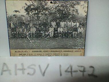
Photograph, Ambulance Officers Training Centre Course 200, Recruit Course, 1977, 1977
Front Row L to R: J. Brereton, d. Catteral, M. Chilton, L. Cooke, P. Crew, K Crowle, J. Engledow, K. Filcock, K. Ford, R. Green, K. Holt, M. Hunting, C. Linke, S. Lamb, J. Lee. Back Row L to R: J. Lennon, D. Lumby. J. McDonald, P. Malone, T. Nunn, R. Paravinic, J. Poole, R. Reid, W. Sampey, P. Sanger, E. Schanssema, K Struthers, P. Turner, N. White, R. Williams, P. Williams. P. Worboys.Black and White photograph of ambulance officer recruitsambulance officers training centre, recruits -
 Kew Historical Society Inc
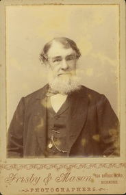
Photograph - John Padbury
Padbury’s Funeral Parlour in Kew was the earliest business of its kind in what is now the City of Boroondara. It was established by John Padbury in 1859. Following his death, the company was renamed A W Padbury & Co. John Padbury was involved in meetings in 1861, calling for Kew to become an independent municipality. In 1863, he argued that a lunatic asylum would bring business to shopkeepers. His company was located at 13 Cotham Road, next to the rear entrance of the Kew Police Station. The two-storey building is still [in 2023] extant. Members of the Padbury family married into a number of pioneer Kew families including the Whitmans and Morgans. Rare portrait of a significant Kew pioneerOriginal print positive 'cabinet card'. Portrait of John Padbury, first undertaker in Boroondara. Obverse: “Frisby & Mason / Photographers / 134 Bridge Road Richmond”. Reverse: “John Padbury / founder of Padbury Undertakers Cotham Rd Kew / died 90 yrs / Whitman”funeral parlours. -- kew (vic.), a w padbury, john padbury, businesses -- cotham road -- kew (vic.) -
 Surrey Hills Historical Society Collection
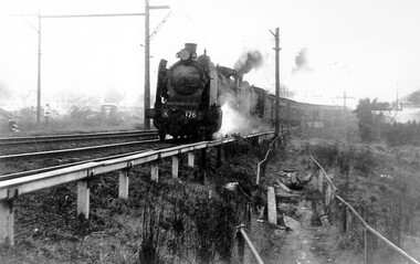
Photograph, Loco K176 at Surrey Hills on a vintage tour train to Healesville, 1 October 1966, 1 October 1966
We have an original B&W copy donated by Ian Barkla and a larger one copied by Ken Hall. The Barkla original has a sticker with his reference details on the back. The photo records a Vintage Train tour to Healesville on 1 October 1966. The Lilydale to Healesville line opened on 1 March 1889. The last steam train on the line ran in 1957 and the last passenger service was in 1980. The line reopened as a tourist railway in 2010. Although the photo was taken on a misty day, houses in Windsor Crescent can just be seen in the background. It is possibly Lorne Parade in the background with preparatory works for the 3rd rail line underway.A black and white photocopy of a steam train. One person is looking on from the left hand side of the photo. It's a misty day but houses in Windsor Crescent and the pedestrian overpass at Surrey Hills railway station can be seen.surrey hills railway station, windsor cresent, 1966, railfan tour, steam trains, vintage tour train