Showing 110191 items matching "roads"
-
 Eltham District Historical Society Inc
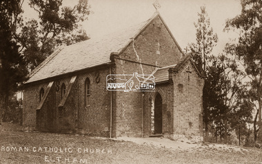
Negative - Photograph, St Mary's Roman Catholic Church, Eltham, c.1910
Note the extensive cracking of the mortar and bricks in the front facade near the portico entrance. The original St Mary’s Roman Catholic Church (1865-1912) was built of clay brick with buttress walls and a slate roof on the corner of Fordhams Road and Maria Street (Main Road), Eltham South, opposite the present-day Wingrove Park. It was blessed on September 3, 1865. With the arrival of the railway in 1901 and the town centre moving closer to the station, the decision was made to relocate the site of the church to its present-day location on Henry Street at the corner of Main Road. A new timber weatherboard church, also called St Mary's was erected and blessed on October 13, 1912. The church and land cost £1,400 (Evelyn Observer). The original brick church It was demolished in the 1920s and the bricks and windows were recycled to build a dairy on the Brinkkotter farm at Research. The timber church was destroyed by fire in 1961 and a new modern architectural (1960s) style church was erected in its place and named Our Lady of Help Christians Church.This photo forms part of a collection of photographs gathered by the Shire of Eltham for their centenary project book,"Pioneers and Painters: 100 years of the Shire of Eltham" by Alan Marshall (1971). The collection of over 500 images is held in partnership between Eltham District Historical Society and Yarra Plenty Regional Library (Eltham Library) and is now formally known as the 'The Shire of Eltham Pioneers Photograph Collection.' It is significant in being the first community sourced collection representing the places and people of the Shire's first one hundred years.Digital image 4 x 5 inch B&W Neg Sepia postcardsepp, shire of eltham pioneers photograph collection, eltham, roman catholic church, church, catholic church, main road, st marys catholic church -
 Eltham District Historical Society Inc
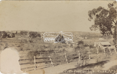
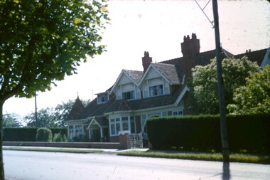
Postcard - Photograph, Eltham from Greensborough Road, No. 1, c.1910
The view is looking southeast from near Eltham Road (present-day Sherbourne Road) across Bolton and Bridge streets towards the village of Little Eltham running down the main road (Maria Street) . On the immediate right is Mrs Mary Jane Smart's family home located on the north side of Bridge Street at the intersection with Bolton Street, facing Bolton Street (now part of present day Brisbane Street and occupied by the Kitchen Design Centre). An original early settler's cottage, it was built by Mary Jane Smart's parents, Edwin Bailey and Jane (nee Matthews). Mary Jane Smart was born in the cottage. She married an Englishman, Alexander Wilson Smart who disappeared to Western Australia in the early 1900s in search of gold. He ultimately married again in W.A., committing bigamy and then committed murder and was hung in 1911. Visible at the top left are Watson's (two-storey) Eltham Hotel at the corner of Pitt Street and Maria Street and the Evelyn Hotel directly opposite.Sepia postcardNotations in biro 'A. Petrie', rest in pencil as follows St Margarets N end Shows Wesleyan Church Small Bank Double Storey on Hotel's south end Pearsons house Note roof structure Surface damage to lower left corner1910, bridge street, cba bank, church, clark bros. photo, early settlers, eltham, eltham hotel, evelyn hotel, fountain of friendship hotel, greensborough, mary jane smart (nee bailey), pearson house, pre 1900, road no 1, smart family home, smart home, st margarets, watsons hotel, wesleyan church -
 Eltham District Historical Society Inc
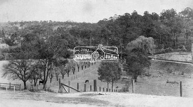
Negative - Photograph, Rose Stereograph Company, View at Eltham, Vic, c.1920
View at Eltham, Vic. Looking from Main Road near Henry Street towards Montmorency showing the railway trestle bridge. Henry Street road reserve on west side of Main road in foreground. c.1920 Copy of Rose Series Postcard P. 4348. (The Rose Stereograph Company) George Rose founded the Rose Stereograph Company in 1880 and was joined by Herbert (Bert) Cutts in the early 20th Century. The pair formed a lifetime working partnership and strong personal friendship. Assisted by George’s two sons, Herbert George and Walter, and later by Neil Cutts, the Rose Stereograph Company continued its operations for more than 140 years. The company was initially built on stereographs, but as cinema took over and stereographs fell out of fashion, the Rose Stereograph Company developed Australia’s first commercially viable photographic postcard business. Specialising in postcards of iconic historical moments and significant landmarks, The Rose Stereograph Company became a staple of the Australian travel industry. This photo forms part of a collection of photographs gathered by the Shire of Eltham for their centenary project book,"Pioneers and Painters: 100 years of the Shire of Eltham" by Alan Marshall (1971). The collection of over 500 images is held in partnership between Eltham District Historical Society and Yarra Plenty Regional Library (Eltham Library) and is now formally known as 'The Shire of Eltham Pioneers Photograph Collection.' It is significant in being the first community sourced collection representing the places and people of the Shire's first one hundred years.Digital image 4 x 5 inch B&W Negbridge street, eltham, eltham railway trestle bridge, postcard, rose stereograph company, shire of eltham pioneers photograph collection, trestle bridge -
 Kew Historical Society Inc
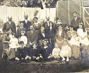
Photograph - Family portrait, The Marshall Family, 1903-1914
Captain John Marshall was born in Dundee, Scotland c.1833. Within eleven years of his arrival in Melbourne in 1852, he had established an important colonial shipping company, Anderson & Marshall, and married Mary Austin, the eldest daughter of Thomas Austin Esq of Clifton Villa in Cotham Road. Elected to the Kew Borough Council in 1869, he remained an active member until 1875. During this period, he was elected Mayor of Kew in 1872. A Scottish Protestant by birth and conviction, John Marshall was, with David Beath, a member of the inaugural committee that began planning for a separate Presbyterian Church in Kew, lending the Committee the funds to purchase land on the corner of Cotham Road and Highbury Grove. John Marshall lived at his home, 'Maryfield', at what was then 239 [now 197] Cotham Road until shortly before his death at the age of 70 in January 1903. He was buried on 14 January in Grave 493, Presbyterian Compartment A, Boroondara General Cemetery.Family portrait of the relatives of an important civic figure in Kew in the 19th century who was also a notable businessman and shipowner in the Colony of Victoria.Albumen silver photograph on card of the Marshall family grouped in three rows in a garden setting. The twenty-three members of the extended family do not include John Marshall so the photograph presumably dates from after his death in 1903. His wife, Mary Marshall, is in the middle row, five from left. marshall family, john marshall -- mayor of kew -
 Melbourne Legacy
Slide, Harelands, 1950s
Slide photograph of the exterior of Harelands on a cloudy day from across Willesmere Road. Harelands was at 5 Willesmere Road on the corner with Burke Road. Harelands was a residence run by Melbourne Legacy to take care of children whose fathers were deceased servicemen, and who may have been left orphans, or whose mother may have been unable to care for them herself, or they needed to stay in Melbourne for education. Harelands generally looked after children up to the age of 14. Boys then moved to Blamey House and girls went to Stanhope. Harelands was built in the Queen Anne style and is now heritage listed. The slide is a second copy - as it has a red slide number printed on it. It appears to be part of a roll of slide film that also included photos of the outside of Blamey House. The slides have been photographed to make digital images and moved to archive quality sleeves. In many cases the original images were not well focussed and the digital image is the best available.A record of the outside of Harelands.Colour slide of the exterior of Harelands, in a brown Kodachrome cardboard mount with red edges printed on the reverse.Handwritten on front 'Harelands' in blue pen. Imprinted with 13 in red ink.residences, harelands -
 Surrey Hills Historical Society Collection
Photograph, Holy Trinity Tennis Club, 1941, 1941
Holy Trinity originally held their first organised services during 1885 in the recreation hall in Albany Crescent, Surrey Hills with the Reverend H E Taylor, then Vicar of St Barnabas, Balwyn, conducting the services. Mr E D Dyer donated the land for a church on the corner of Mont Albert Road and St George's Road, Mont Albert with the foundation stone being laid on 17 July 1886. The first church service was held on Sunday, January 30, 1887 with eighty people present. A new site on Union Road, Surrey Hills was acquired (lots 3 & 4) and a wooden church was erected and opened in 1907 on lot 4. It became known as Holy Trinity Surrey Hills. In November 1939 two tennis courts and a pavilion were erected on land acquired by the parish in a lane off Balmoral Crescent. The Holy Trinity Tennis Club had 80 years of distinguished success in match play until it closed in 2014. That land was sold in 2015 and the parish's real estate holdings diversified.Black and white photo of 9 ladies, in tennis dresses and shoes, and 8 men, also in tennis attire. They are posed next to a light coloured building on the right and a paling fence along the back left side. There are 5 men standing at back, 6 ladies and 1 man standing in the next row, 4 ladies sitting in front and 2 men sitting on the ground. Three ladies sitting are holding tennis racquets. There are trees behind the paling fence. Black and white photo mounted on card; photo measures W 11.1 cm x H 6.7 cm.sporting clubs, sports people, tennis, holy trinity anglican church, 1940 - 1949, mrs mary clucas -
 Eltham District Historical Society Inc
Photograph - Digital Photograph, Marguerite Marshall, Former Head Teacher's residence, Eltham Primary School, Dalton Street, Eltham, 7 September 2008
Built in 1891 for Head Teacher John Brown. His predecessor and the school's first Head Teacher, John Clark, lived in his own house 'Shoestring' in Metery Road, adjacent to the school. At the time of this photograph, the building was being used for before and after school care. Its present-day (2023) use is for school administration offices. Covered under Heritage Overlay, Nillumbik Planning Scheme. Published: Nillumbik Now and Then / Marguerite Marshall 2008; photographs Alan King with Marguerite Marshall.; p49 The former head teacher’s residence on 690 Main Road, was built in 1891 for the head teacher, John Brown. His predecessor David Clark lived in his own house known as Shoestring at Metery Road, possibly built in the late 1850s. With the school, Wingrove and Jarrold Cottages, it makes up the original Eltham township south of Dalton Street’s only group of 19th century buildings. The two Monterey Pines were popular vegetation in the late 19th and early 20th centuriesThis collection of almost 130 photos about places and people within the Shire of Nillumbik, an urban and rural municipality in Melbourne's north, contributes to an understanding of the history of the Shire. Published in 2008 immediately prior to the Black Saturday bushfires of February 7, 2009, it documents sites that were impacted, and in some cases destroyed by the fires. It includes photographs taken especially for the publication, creating a unique time capsule representing the Shire in the early 21st century. It remains the most recent comprehenesive publication devoted to the Shire's history connecting local residents to the past. nillumbik now and then (marshall-king) collection, dalton street, eltham, eltham primary school, headmaster's residence, main road, state school no. 209 -
 Ringwood and District Historical Society
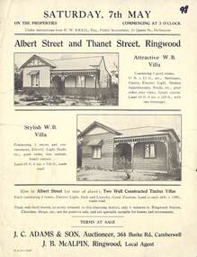
Flyer, Auction Sale Brochure - Adjoining Weatherboard Villas, Albert Street and Thanet Street, Ringwood - circa 1921
Single page advertisement with black and white photographs of two adjoining timber villas fronting Albert Street and Thanet Street, Ringwood for auction on Saturday, 7th May (1921?).Under instructions from E.W. Smail, esq., Public Accountant, 31 Queen Street, Melbourne. Two well constructed timer villas, each containing 5 rooms, electric light, bath and laundry, good position, land to each 66ft x 258 ft., made road. These well-built homes, so nicely situated in this charming district, only 6 minuts to Ringwood Station, Churhes, Shops, etc., are for positive sale, and are specially suitable for homes and in estments. Terms at sale. J.C. Adams & Son, Auctioneer, 364 Burke Road, Camberwell. J.B. McAlpin, Ringwood, Local Agent. -
 Ringwood and District Historical Society
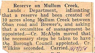
Newspaper, Scrapbook Clipping, Library Collection, Ringwood, Victoria
Newspaper Clipping from un-named local paper re Reserve on Mullum Creek, category of PARKS, GARDENS, RESERVES. Dated 18-7-1928Lands Department, intimating that a reserve had been created of 10 acres along Mullum Creek between Oban Road and Brewer's, and asking that a committee of management be appointed. -- Cr. McAlpin moved that the necessary steps be taken to have the Borough Council appointed. Cr. Wilkins seconded. Carried. -
 Ringwood and District Historical Society
Flyer, Subdivisional Land Auction Sale Brochure, Grand Central Estate, Ringwood, Vic. - 1925
Douglas Street shown in the estate plan did not eventuate, but was developed as a public reserve. Refer also to Reg. No. 5149 for 1924 auction sale of land also titled Grand View Estate situated further north in Ringwood.Double sided multi-folded page advertising public auction sale on Saturday, 31st October, 1925, of residential allotments highlighting local facilities, services and layout of the estate. Includes panoramic view of Ringwood and other local photographic images.Subdivision includes Great Ryrie Street, Heathmont Road, Douglas Street, Garden Street, and Bellevue Avenue. Agents - Knight & Harwood, 315 Collins Street, Melbourne, Phone 10615, 10616 Central, in conjunction with J.B. McAlpin, Opposite Railway Station, Ringwood. Phone Ringwood 7. -
 Ringwood and District Historical Society
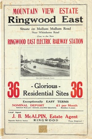
Flyer, Land Sale Brochure, Mountain View Estate, Ringwood East, Vic. - 1923
Bi-fold advertisement for sale of residential allotments, including photographs, map, and summary of subdivision features and local facilities. Undated handwritten notation reads "streets don't exist today".Subdivision layout includes Mullum Mullum Road, Rangeview Avenue, Press Avenue, and Mountview Avenue. Local Agent - J.B. McAlpin, Opposite Railway Station, Ringwood, Phone Ringwood 7. Vendor - T.J. Press, Builder, "Monterey", Second Avenue, Kew, Telephone Haw. 3428. -
 Ringwood and District Historical Society
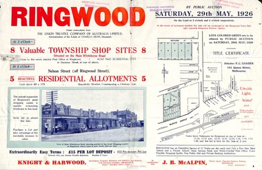
Flyer, Township Shop Sites and Residential Allotments Sale By Public Auction, Ringwood, Victoria - 1926
Advertisement for eight township shop sites and five residential allotments for sale by Public Auction on the land in Ringwood on Saturday, 29th May, 1926, with location map, and summary of local features and services. Locality plan highlights sites for auction in Nelson Street, Seymour Street and Whitehorse Road. (Agents) Knight & Harwood, 315 Collins Street, Melbourne, Phones 10615, 10616 Central, in conjunction with J.B. McAlpin, Estate Agent, Opposite Railway Station, Ringwood, Phone Ringwood 7. -
 Ringwood and District Historical Society
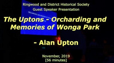
Mixed media - Video, RDHS Guest Speaker Presentation - "Orcharding and Memories of Wonga Park" - Alan Upton
Digitised video (3.06GB) Duration: 56 minutes. Recorded November, 2019 (Video is available for viewing at Ringwood & District Historical Society Archives by appointment)Presenter: Alan Upton has spent his life growing fruit, both at the original Upton orchard in Wonga Park and at Yering on the Healesville Road. In that time, there have been many changes to not only agricultural methods and techniques but also to the local area, as covered by Alan in this video presentation. -
Ringwood and District Historical Society
Document, Ringwood Bowls Club- Letterhead, Ringwood Bowls Club Inc., 2000
Copy of Letterhead.Ringwood Bowls Club Inc. A0001899A 2-12 Loughnan Road, Ringwood, 3134. P.O. Box 149, Ringwood, Vic 3134. Telephone (03) 9870 6767. Fax (03) 9870 6711. www.ringwoodbowls.asn.au [email protected] 18th April 2000. Photograph of greens included. -
 Jewish Museum of Australia
Chess set
This chess set was carved from local wood with bases made from halved cotton reels. The chess pieces take the shape of Australian animals, and Aboriginal men and women. The set was presented to Mr. Benzion Patkin, Honorary Secretary of the Zionist Federation of Australia, by Tatura internees in recognition of his assistance, in particular, his assistance in facilitating the emigration to Palestine. According to Mr. Patkin, he received the chess set in a wooden box inscribed, "With our sincerest thanks from your Zionist friends - Tatura, on the way to Eretz Israel, per Leonhard Levin, 20.11.1942.".Written in pencil UR corner, upside down: (22) Printed in black ink: "B. & H. PATKIN Flat (printed 2 corrected in pen and ink 4) 313a Dandenong Road Windsor 3181 Victoria Australia Tel: Home 51 - 5671 Bus 63 - 8959"dunera, wwii, internees, jewish history & people -
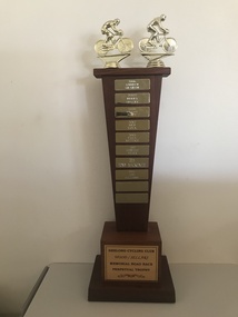 Geelong Cycling Club
Trophy
Messrs Wood and Sellars names are on the trophy in recognition of their service to the Geelong Cycling Club.Club volunteers are important to the club and this trophy serves to recognise endeavours in this field. This trophy is in the shape of a wooden column set on two small wooden bases. The second base has a plaque attached to it with the title of the trophy. The column of the trophy has small rectangular plaques with the name of each winner inscribed on them dated from 2006-2016. Images of two cyclists in an embossed gold colour are fixed to the top of the trophy. "Geelong Cycling Club/Wood/Sellars/Memorial Road Race/Perpetual Trophy/2006/Andrew Graham/2007/Terry Stacy/2009/Brian Happ/2012/Ned Volk/2013/Paul Rettke/2014/Shantelle Maurer/2015/Tony MacKenzie/2016/Josh Williams"geelong cycling club; wood; sellars; andrew graham; terry stacy; brian happ; ned volk; paul rettke; shantelle maurer; tony mackenzie; josh williams; -
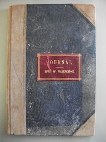 Warrnambool and District Historical Society Inc.
Financial record - Journal Town of Warrnambool 1914-1926, Circa 1914
This journal shows payments made for a number of Council and community expenses. It includes entries relating to Town Hall, Botanic gardens, Parks, road costs, baths, beach improvements, Warrnambool Racing Club. It shows account transfer journals Provides an overview of expenses of Council in the early 20th century.Dark blue water wave fabric over card with light brown points and binding. Red leather label with gold text and border. Pages edged in pink green, yellow and white pattern. 102 Pages.Journal Town of Warrnambooltown of warrnambool 1914-1926, warrnambool expenses 1920, warrnambool town hall, warrnambool baths -
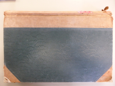 Warrnambool and District Historical Society Inc.
Financial record - Ledger Warrnambool City Council cash book 1940-1946, Circa 1940
This cash book contains details of payments made and money collected from the period 1940-1946 There are expenses such as road maintenance, stationery, Abattoirs, ice, Botanic Gardens, Booval Gardens, beach improvements, sanitary services, salaries and wages.This cash book provides a detailed description of the day to day expenses of running a city council in the 1940’s. Large green cloth hard cover with tan point and spine. Inside front and back covers is patterned red and blue with thick black diagonal lines. It has binding tape inside front and rear covers. 201 pages edged in pink, green, yellow, and white. The pages have the heading in black print, “City Of Warrnambool.”Label inside front cover,” E. Whitehead & Co, Pty Ltd, Stationers, general Printers and Account Book Manufacturers, Griffin House, 21 Equitable Place, Melbourne. Ref No. 16380. warrnambool city expenses 1940, warrnambool city ledger 1940-1946, warrnambool history -
 Eltham District Historical Society Inc
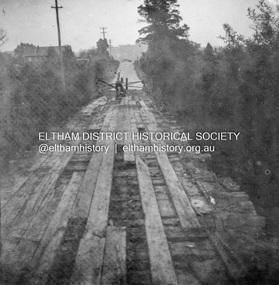
Album - Photograph, J.A. McDonald, Eltham-Greensborough Road, 26 July 1956
Diamond Creek Bridge (Bridge Street Bridge) Old bridge from N.W. bank Handrails stripped – 26/7/56 View looking west along bridge to Susan Street intersection with barriers placed across the roadRecord of various Shire of Eltham infrastructure works undertaken during the period of 1952-1962 involving bridge and road reconstruction projects, sometimes with Eltham Shire Council Project Reference numbers quoted. It was during this period that a number of significant improvements were made to roads and new bridges constructed within the shire that remain in place as of present day (2022). In many situations, the photos provide a tangible visible record of infrastructure that existed throughout the early days of the Shire. The album was put together by or under the direction of the Shire Engineer, J.A. McDonald.infrastructure, road construction, shire of eltham, bridge construction, bridge street bridge, eltham, eltham-greensborough road, 1956-07-26 -
 Eltham District Historical Society Inc
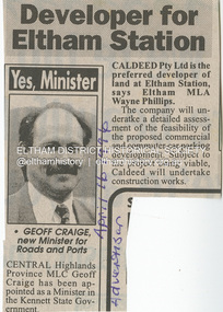
Document - Property Binder, 967 Main Road, Eltham
Newspaper article: Developer for Eltham Station, The Advertiser, April 16, 1996 The original Station Master's house situated in present-day bus bay was sold in 1986 for $1 to save it from demolition and was then relocated to 58 Park Road.58 park road, 967 main road, businesses, eltham, eltham railway station, houses, main road, property, station masters house, station master's house eltham -
Eltham District Historical Society Inc
Document - Folder, Powell, Margaret
Margaret Powell taught and exhibited pottery, to hold her first solo exhibition at her studio home, Haldane Road, Eltham. Contents Newspaper article: "First solo show", No masthead, no date. Margaret Powell's career as a potter.Newspaper clippings, A4 photocopies, etcmargaret powell, haldane road eltham, diamond valley arts society -
Glen Eira Historical Society
Document - Hall, Hugh Percival
Typed biography on the life and times of Hugh Percival Hall, by his daughter Felicitie E. Campbell dated March 2006. He was a solicitor, artist and photographer and his grand-father built Glenmoore in St. George’s Road, Elsternwick.artists, hall hugh percival, caulfield grammar school, glenmoore, mansions, house names, ballet in australia from pavlova to rambert, photography, statues, watkin joyce leslie, moore hugh, hall felicitie elizabeth, campbell felicitie elizabeth, campbell andrew john egan, campbell carol, meares diugan and hall, ballet and dance, campbell alistair, campbell ross, campbell robyn, campbell lynette, glen eira road, steadman cameron meares and hall, tennis courts -
Glen Eira Historical Society
Article - Esakoff, Margaret
Article from The Age dated 18/08/2011 titled Mayor’s Husband Lobbied on Heritage. Refers to a property on corner Hawthorn Road and Seaview Street, Caulfield South. Considerable council debate on Heritage Protection was generated by this situation.esakoff margaret mayor, seaview street 2a and 2b, caulfield south, heritage protection, glen eira council, hawthorn road, briggs john, esakoff john, hyams jamie -
 Eltham District Historical Society Inc
Document - News Clipping, Auction - Part of Eltham history
Copy of undated article headed "Auction part of Eltham history" regarding sale of property at 816 Main Road, Eltham (In March 2020 the site of Goodstart Early Learning Eltham) on the corner of John Street owned by the Burgoyne Family.1 page A4 photocopyHG Booklet 37816 main road, burgoyne, h. burgoyne, harry burgoyne, harry gilham collection, hawthorns, john james thomas neville burgoyne -
 Eltham District Historical Society Inc
Slide, Construction of Eltham Town Park, 25 Jul 1973
Construction of Eltham Town Park; landscape has been scupltured and lakes formed. Shillinglaw Cottage , Main Road, Eltham Shire Council Offices and Catholic Church all visible. The park was later renamed Alistair Knox Park.35 mm colour positive transparency Mount - Agfacolor Service (Blue)Memorial Park 25 July 1973eltham, main road, alistair knox park, eltham town park, shillinglaw cottage, bridge street -
 Phillip Island and District Historical Society Inc.
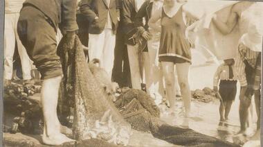
Photographs, 1926
Part of a collection of photographs from an old photo album with multiple photos per page. Donated by Margaret Webster. Her parents were Sir Charles & Lady McGrath who lived on Ventnor Road, Cowes near the RSL286-12 - Sepia photograph of a group of people with a net of fish at Cowes, Phillip Island. 286-13 - Sepia photograph of two women on the beach at Newhaven, Phillip Island. 286-14 - Sepia photograph of three people and a car at Newhaven, Phillip Island. 286-15 - Sepia photograph of a woman holding a Mutton Bird. 286-16 - Sepia photograph of Forrest Caves, Phillip Island. 286-17 - Sepia photograph of three people on rocks at Forrest Caves, Phillip Island.286-12 - "A haul of trout, Cowes." 286-13 - "Newhaven, Phillip Island" 286-14 - "A rest a Newhaven P.I." 286-15 - "A Mutton Bird P.I." 286-16 - "The Caves P.I." 286-17 - "Forest Caves P.I." (Should be "Forrest" with two "r's")forrest caves phillip island, fishing catch, newhaven, mutton bird, native wildlife, margaret webster -
 Phillip Island and District Historical Society Inc.
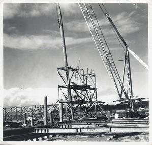
Photographs, Phillip Island 2nd Bridge Construction, 1966 - 1969
22 of a collection of 70 Black & White photographs taken during the construction of the second Phillip Island Bridge from San Remo to Newhaven by Country Roads Board and Shire of Bass. Contractor John Holland & Co. Pty. Ltd.14 Black & White photographs of the construction of the second Phillip Island Bridge in 1966 - 1969. 351-09: Pile driving on Newhaven abutment. 351-10 & 11: Concrete beams. 351-12: Pile driver. 351-13 & 14: Machinery. 351-15: Dismantled section of cylinder. 351-16 & 17: Coffer dam and pier construction. 351-18: Man up on scaffold. 351-19 & 20: Construction work. 351-21: Two workmen and man leaning on section of handrail exposed to weather. 352-22: View of construction work.Descriptions as above on some. Plus the following Numbering: 351-09: CRB NEG 67-274C. 351-10: CRB NEG 67-542. 351-11: CRB NEG 67-654F. 351-12: CRB NEG 66-605. 351-13: CRB NEG 66-601. 351-14: CRB NEG 68-752B. 351-15: CRB NEG 67-936. 351-16: CRB NEG 67-937A. 351-17: CRB NEG 67-937B. 351-18: CRB NEG 67-1156D. 351-19: CRB NEG 67-1156B. 351-20: CRB NEG 66-1026E. 351-21: CRB NEG 67-940. 351-22: CRB NEG 67-1218Bphillip island bridge construction, 2nd phillip island bridge construction, country roads board, shire of bass, sasha stark -
 Phillip Island and District Historical Society Inc.
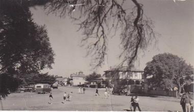
Photograph, San Remo
Broad view of The Esplanade beneath an overhanging branch of tree, looking at hotels and shops. On the right is a large bush to the left a large tree. A bus, car and truck are parked to left and unidentifiable figures of people walking to and fro across the road.Esplanade, San Remolocal history, photographs, san remo, black & white photograph, mona condrick -
 Greensborough Historical Society
Photograph - Digital image, Caroline and Ferdinand Barnett and sister, 1940c
Caroline and Ferdinand Barnett and his sister Emily Barnett from Northcote. Taken at 122 Main Road Lower Plenty. Photographs from the collection of Peter Blackbourn, a descendant of the Chapman Stock family. Annotations to photos by Peter Blackbourn.Digital copy of black and white photograph.peter blackbourn, caroline barnett, ferdinand barnett, emily barnett, 122 main road lower plenty -
 Greensborough Historical Society
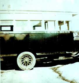
Photograph - Digital image, Heidelberg Eltham bus, 1929c
Heidelberg-Eltham bus, run by Alf Barnett then his brother Stan Barnett. This photograph taken at Bannockburn Road, late 1920s.Photographs from the collection of Peter Blackbourn, a descendant of the Chapman Stock family. Annotations to photos by Peter Blackbourn.Digital copy of black and white photograph.peter blackbourn, alf barnett, stan barnett, heidelberg-eltham bus