Showing 5374 items
matching developing
-
 Deaf Children Australia
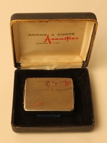
Calaid Hearing Aid, National Acoustic Laboratories, 1960s
The first commercial digital hearing aid was created in 1987 by the Nicolet Corporation. The hearing aid contained a body-worn processor that had a hardwire connection with an ear mounted transducer. While the Nicolet Corporation’s hearing aid was not publicly successful and the company shortly folded, it was able to start a competition between companies to create more effective hearing aids. Two years later, in 1989, the behind-the-ear (BTE) digital hearing aid was launched. In addition to the Nicolet Corporation, Bell Laboratories expanded upon the hearing aid business by developing a hybrid digital-analog hearing aid. When the hearing aid was put on in the market, it was instantaneously successful. This development helped bring major changes to the world of the hearing aid. The next major milestone was creating an all-digital hearing aid. The Oticon Company developed the first digital hearing aid in 1995, but it was only distributed to audiological research centers for research on digital technology in the realm of acoustic amplification. The Senso was the first commercially successful, all-digital hearing aid, and was created by Widex in 1996. After the success of the Senso, Oticon began marketing their own hearing aid, the DigiFocus. Presently, the digital hearing aid is now become programmable. By making the hearing aid programmable, it has allowed hearing aids to be capable of regulating sound on their own, without using a separate control. The hearing aid can now adjust itself depending on what environment it is in and often does not even need a physical volume control button. Silver metal case with side clips and hearing aid attached. Has battery compartment for AA batteries. Volume control is the top left hand corner. Comes with its black case "C OF A/CALAID/101862" on back of case. "ANGUS & COOTE/Acoustics/HEARING AIDS" on inside cover of case -
 Deaf Children Australia
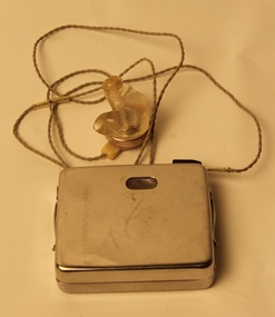
Calaid Hearing Aid, National Acoustic Laboratories, 1955-mid 1970's
The first commercial digital hearing aid was created in 1987 by the Nicolet Corporation. The hearing aid contained a body-worn processor that had a hardwire connection with an ear mounted transducer. While the Nicolet Corporation’s hearing aid was not publicly successful and the company shortly folded, it was able to start a competition between companies to create more effective hearing aids. Two years later, in 1989, the behind-the-ear (BTE) digital hearing aid was launched. In addition to the Nicolet Corporation, Bell Laboratories expanded upon the hearing aid business by developing a hybrid digital-analog hearing aid. When the hearing aid was put on in the market, it was instantaneously successful. This development helped bring major changes to the world of the hearing aid. The next major milestone was creating an all-digital hearing aid. The Oticon Company developed the first digital hearing aid in 1995, but it was only distributed to audiological research centers for research on digital technology in the realm of acoustic amplification. The Senso was the first commercially successful, all-digital hearing aid, and was created by Widex in 1996. After the success of the Senso, Oticon began marketing their own hearing aid, the DigiFocus. Presently, the digital hearing aid is now become programmable. By making the hearing aid programmable, it has allowed hearing aids to be capable of regulating sound on their own, without using a separate control. The hearing aid can now adjust itself depending on what environment it is in and often does not even need a physical volume control button. Square, silver metal hearing aid with electronics and AA battery compartments. Has an ear piece and ear mould attached by wire, with a volume adjustment. A body level type, probably a CALAID T manufacture from 1955 to the 70's. On front "C OF A/CALAID/108499" deaf children australia, hearing aid, calaid, commonwealth of australia -
 Victorian Aboriginal Corporation for Languages
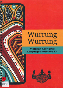
Book, Alexandra Blaszak, Wurrung Wurrung Victorian Aboriginal languages resource kit, 2008
The Wurrung Wurrung Kit is designed to introduce students at all levels to the heritage of Aboriginal languages within the area now known as Victoria. The kit aims to: Create awareness of Victorian Aboriginal languages in the past and present. The kit is not designed for the teaching of languages, Develop students' understanding of the relationship between the languages and culture of Victorian Indigenous people, or Koories, Create awareness of the importance of language to indigenous communities today and to foster respect for these communities and their languages, Highlight the diversity within Aboriginal Victoria and Australia in terms of languages and culture, Provide resources for students and teachers that can be used either as a window into Aboriginal culture generally, or to complement a broader unit of work in indigenous studies. Resources for teachers Purpose of this kit Using this kit Terminology Pronunciation Facts about Aboriginal languages in Victoria Language and Aboriginal culture Revitalizatoin of Aboriginal languages Language Alive in the community Community protocols Understanding the Language Map VELS and Curriculum links Teaching Framework Resources and contacts Activities for students Animal names Colouring in Possum Koala Kangaroo Code breaker What do yo know? Concentration Sounds, spellings and symbols Kinship Different things, different words Koorie Garden Timeline Story of Victorian Languages Language on the Mission Role Play Traditional Owners Placenames Graffiti Wall Map References.maps, b&w photographs, b&w illustrations, colour illustrations, games, referenceswoiwurrung, boonwurrung, gunnai kurnai, djadjawurrung, wathaurong, keerraywoorroong, jardwadjali, wergaia, ladjiladji, taungurung, dhudhuroa, kulin -
 The Beechworth Burke Museum
Audio - Oral History, Jennifer Williams, Mr Ken Blake and Mrs Doreen Blake, 30th March 2000
Ken and Doreen came to Beechworth on boxing day in 1959, when they were offered a business at a good price. This business was the Ovens and Murray advertiser, one of the oldest running newspapers in Australia. When they arrived Ken already had a background as a professional linotype operator, however both him and Doreen had no experience running a town newspaper. Ken and Doreen owned the paper till the 1980s, when they formed the Blake press. Throughout the years the Blakes kept up to date with Beechworth news, politics and events happening throughout the community, Ken was even permitted to sit in on the town committee meetings. They saw the town develop from a small mining town in rural Victoria, to a bustling, tourist hotspot.This oral history is significant because it shows how the town of Beechworth developed from a small outpost mining town to a popular tourist destination. It also showcases a different perspective of the towns development, that of the new owners (at the time) of the Ovens and Murrary Advertiser. The advertiser is an integral part of Beechworth's history and has been running since it was proclaimed a town (proclaimed a town in 1856, the advertiser first ran its paper in 1855). Without the advertiser the history of Beechworth would be buried, but with newspapers dating back all the way to 1855, Beechworth is provided with a rich and vibrant retelling of the history of their town and what life was like from 1855 to present day. Ken and Doreen's oral history provides an insight into what it was like revitalising a worn out part of history, of restoring it back to its former glory. They demonstrate the highs and lows of living and running a business in Beechworth through economic lows and the impact of both social and physical isolation.This is a digital copy of a recording that was originally captured on a cassette tape. The cassette tape is black with a horizontal white strip and is currently stored in a clear flat plastic rectangular container. It holds up 40 minutes of recordings on each side.newspaper, blakes, ken and doreen, ovens and murray advertiser, beechworth, development, o&m, 1960s, 1980s, 1970s -
 Orbost & District Historical Society
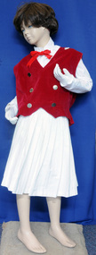
uniform
The sport had its origins during the Depression of the 1930s when teams were formed to keep young women fit and healthy. The sport became more organised during the 1940s with a system of scoring developed to ensure teams could compete against one another. Points were deducted for lack of precisions, dressing, movement and length of pace. At its peak marching competitions drew large crowds of spectators. Teams marched not only in competitions but also frequently appeared in parades and social occasions. Jim Trewin trained Orbost's Marching Girls' team, the Waratahs, and served as vice president of the East Gippsland Marching Girls' zone. His wife, Doris, acted as chaperon Together with a trophy, a chaperone's blazer and photos this uniform forms part of the history of the Orbost Marching Girls group.An Orbost Marching Girls' uniform It has a white pleated skirt, a long-sleeved white blouse and a red velvet vest with 6 gold buttons. There is a badge on the left shoulder. A red ribbon is attached to the blouse as a bow tie. On the vest shoulders are white tabs with gold buttons. The skirt and blouse are made of cotton. A pair of short white gloves are included.On badge- Victorian Girls Marching Associationuniform marching-girls leisure clubs recreation -
 Eltham District Historical Society Inc
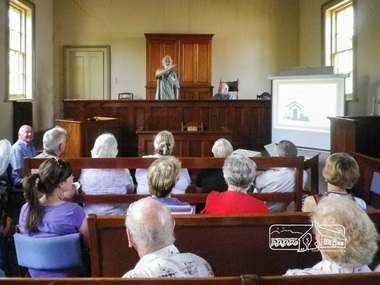
Photograph, Joint meeting between Eltham District Historical Society and Greensborough Historical Society held at Eltham Courthouse, Saturday, December 8, 2012, 8 Dec 2012
Presentations by Harry Gilham and Jim Connor of Eltham District Historical Society and Noel Withers and Sue Ballantyne of Greensborogh Historical Society. EDHS Newsletter No. 207 November 2012 Following on from a suggestion by Harry Gilham, our Society will host a joint meeting with members of the Greensborough Historical Society at the Eltham Courthouse on Saturday 8 December, between 2.00pm and 4.30pm. We are pleased to have developed a good working relationship with the recently established Greensborough Historical Society and look forward to welcoming their members to Eltham. This meeting will focus on the Eltham Courthouse and its former use. We encourage all EDHS members to attend and share time with our visitors. Afternoon tea will be provided.15 Born Digital images (on CD-R)adrian jones, alan butler, alison delaney, doug orford, eltham courthouse, eltham district historical society, greensborough historical society, harry gilham, jim allen, jim connor, joan castledine, maureen jones, noel withers, richard pinn, society meeting, sue ballantyne, sue law -
 Kiewa Valley Historical Society
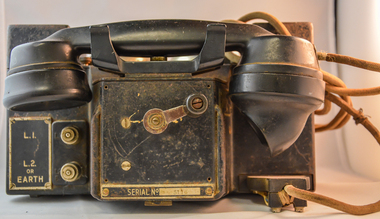
Telephone Handset Field, early 1900s
This field telephone was developed primary for military purposes (World War I) and other wars/military interventions there after. It was the first "mobile" telephone which had a prime objective of providing isolated or "hard" to connect with locations instant communication links. Like a lot of "new" technologies it evolved from a war environment. This handset was used to connect offices and workshops, which due to their functions could not be co-located with their prime office(external workshops).The evolution from the early 1900s to the mid 1980s when mobile communication technology progressed in leaps and bounds from hard wire telephone communication to mobile digital receivers. This handset was manufactured by a subcontracted Australian company under the Australian Post Office mandate.This handset is significant in that it was donated by the Mount Beauty Timber yards and formed an integrated part of its communication system with its out lying work yards and buildings, before the mobile handset evolution. This handset was located in an environment which required a rugged and reliable day to day communications linkage as a vital part of its logistical (business) survival. As progress demands it, the faster that customers are satisfied with the service they obtain from suppliers the longer those services will be asked for and the longer and more profitable the supplier will be. This edict is as true for rural companies as it is for small or large city businesses. The customer is "always" right.This sturdy field telephone has a shell housing made in black bakelite material with a "U" form housing the major components (wiring, magneto and batteries). The main housing has two metal bells, with a central ringer between both, on the top part (to notify incoming calls). In front of the main structure is a box with the telephone hand piece (ear and mouth receptacles) nestled on two cradles. An on/off switch is activated when handset is removed from its cradle. On the front of the control box is a winder handle(to ring off) and in a field situation to activate/deactivate the magneto. To the left of the winder but on the the main body are two wind up connection buttons for the connection of operational wires (power)On the main right hand front body and next to two chrome switches is a plate with "L (next to the top switch) and below this "L2" and underneath this are "or" "EARTH". There is a plate fastened to the front of the handset and behind the winder with "REPLACE HANDSET WHEN FINISHED" and below the winder 'SERIAL NUMBER 5116"field telephone, world war ii field telephone f mk i -
 Eltham District Historical Society Inc
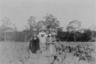
Photograph, From left: Unknown, Mario Fabbro and possibly Helen Skipper, Bell Street, Eltham
At Bell Street, Fabbro Farm, Eltham; From left: Unknown, Mario Fabbro and possibly Helen Skipper, standing in the middle of a vegetable crop. The site of the Fabbro farm (Diamond Creek side land) is now called Barrack Bushlands. It is doubtful that Fabbro's farm holding was ever called Barrak Park, This title is fairly recent after the Shire of Eltham purchased the land, including the last section in 1993/94. About this time the area on the west side of Falkiner Street was purchased by a private developer and developed as housing. The area in Bell Street opposite the Eltham High School was purchased by the State Government is recent years and is called Fabbro Fields. The Fabbro Family operated their farm in Bell Street, Eltham. 1 black and white photographfabbro's farm, bell street, eltham, maurice fabbro, farming, helen skipper, vegetables -
 Eltham District Historical Society Inc
Photograph, Fabbro's farm, Bell Street, Eltham, c.1990s
Fabbro's farm and house, Bell Street, Eltham, c.1990s. A crop of artichokes were planted on the farm at this time. The site of the Fabbro farm (Diamond Creek side land) is now called Barrack Bushlands. It is doubtful that Fabbro's farm holding was ever called Barrak Park, This title is fairly recent after the Shire of Eltham purchased the land, including the last section in 1993/94. About this time the area on the west side of Falkiner Street was purchased by a private developer and developed as housing. The area in Bell Street opposite the Eltham High School was purchased by the State Government is recent years and is called Fabbro Fields. The Fabbro Family operated their farm in Bell Street, Eltham. 1 colour photograph printed with white borderfabbro's farm, bell street, eltham, artichokes, barak farm -
 Eltham District Historical Society Inc
Photograph, Artichokes growing at Bell Street, Eltham, c.1990s
Fabbro's farm and house, Bell Street, Eltham, c.1990s. A crop of artichokes were planted on the farm at this time. The site of the Fabbro farm (Diamond Creek side land) is now called Barrack Bushlands. It is doubtful that Fabbro's farm holding was ever called Barrak Park, This title is fairly recent after the Shire of Eltham purchased the land, including the last section in 1993/94. About this time the area on the west side of Falkiner Street was purchased by a private developer and developed as housing. The area in Bell Street opposite the Eltham High School was purchased by the State Government is recent years and is called Fabbro Fields. The Fabbro Family operated their farm in Bell Street, Eltham. 1 colour photograph printed with white borderfabbro's farm, bell street, eltham, artichokes, barak farm -
 Eltham District Historical Society Inc
Photograph, Maurice Fabbro with artichokes growing at Bell Street, Eltham, c.1990s. Maurie is in his 70s
Fabbro's farm and house, Bell Street, Eltham, c.1990s. A crop of artichokes were planted on the farm at this time. The site of the Fabbro farm (Diamond Creek side land) is now called Barrack Bushlands. It is doubtful that Fabbro's farm holding was ever called Barrak Park, This title is fairly recent after the Shire of Eltham purchased the land, including the last section in 1993/94. About this time the area on the west side of Falkiner Street was purchased by a private developer and developed as housing. The area in Bell Street opposite the Eltham High School was purchased by the State Government is recent years and is called Fabbro Fields. The Fabbro Family operated their farm in Bell Street, Eltham. 1 colour photograph printed with white borderfabbro's farm, bell street, eltham, artichokes, barak farm, maurice fabbro -
 Warrnambool and District Historical Society Inc.
Document - Ledger, Leahy's Electrical Industries Committee, Circa mid 20th century
J. J. Leahy set up his retail electrical business in 1946 selling fridges, stoves and washers after commencing work wiring peoples’ homes in the late 1940’s. He developed the business into a large retail store and electrical contracting business which operated locally and Australia wide... He also ran Beattie and Phillips Funeral directors. The electrical business had several locations along Koroit Street before finally establishing on the south east corner of Fairy and Koroit Street. Jim died in November 26th 2008. The store is still run by his nephew Robert Askew. Jimmy Leahy was involved in the City council for a number of years and served as town mayor. The minutes contained in this book especially the information written in the Managing directors reports, provides an overview not just of a business but of business practice and the changes which occurred in life over the 40 year period. It contains events such as the introduction of television, refrigerated dairies and dates for tenders for major building programs such as WIAE, East Warrnambool School, Town Hall. Large dark blue fabric and leather bound ledger. The index pages are A –Z but contain no entries. Pages 1- 108 are handwritten minutes of Leahy’s Electrical Industries Committee. Pages 109-114 contain typed pages re AGM. Remaining pages are blank. Time period ranges from March 28th 1951 to December 1986. Signatures: J B Dwyer, W J Gleeson J J Leahy. Names included J.B. Dwyer, J.J. Leahy, M White, W.W. Croft, J.J. Walter, W Ross, J.J. Affleck, C.A. Richards, S J Wilson, J Croft, I.L. T Mahoney, P Conheady, J Meade.warrnambool, j.j. leahy, leahy’s, jimmy leahy, ledger, leahy’s electrical -
 Orbost & District Historical Society
black and white photograph, 1850 - 1885
The Lochiel barn was used as the church for all denominations until 1885 when the parishioners were offered the use of a school room, then used the Mechanics' Hall after it was built in 1887. Mr James Cameron, fostered the developing Church, not only by allowing his barn at Lochiel Park to be used for Church services but also by making a home there for Mr Martin ,First Church of England clergyman stationed at Orbost - 1884-1891 over a period of years, until a small Vicarage was built on the spot where the present church stands. From Mr Cameron’s barn the church migrated to the school building erected in the main street and thence after a short time to the Mechanics Hall, built in 1887. This item is reminiscent of the late 19th - mid 20th centuries when church-going was more common.A very old black / white photograph of a house with a barn in the background. The house is on a bush block with many trees around it.on back - handwritten "From Mrs N Edgar, 4 "Heecer" Parade....... Lochiel + Barn M. Gilbert"church-orbost lochiel-barn -
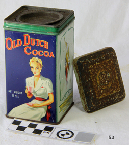 Flagstaff Hill Maritime Museum and Village
Container - Cocoa Tin, First half of 20th Century
The history of metal packaging began in Bohemia in the 1200s. Metal has been produced for a very long time. But the first metal used for packaging was tin. In particular, it was the process of tin plating that was invented in Bohemia. Before this no other metal was economically able to be used for packaging. Later, in 1667 Andrew Yarranton, and English engineer, and Ambrose Crowley brought the method to England. Here it was improved by ironmasters including Philip Foley. Then by 1697, John Hanbury had a rolling mill at Pontypool in South Wales. The method they developed involved rolling iron plates using cylinders. This process enabled more uniform blank plates to be produced than was possible by just hammering the tin. https://www.shilohplastics.com.au/history-of-metal-packaging/The use of tin to protect and store food and other items, revolutionised the world.Tin base and external tin lid, with round internal lid .Colour printed. Used for cocoa. Caption of a woman drinking cocoa, red Australian flag and British flag on other faces. Top embossed "H". Marked - "Old Dutch Cocoa", "Net Weight 8 ozs," (Display side) "Manufactured by Hoadley's Chocolates Ltd, Australia.Top embossed "H". Marked - "Old Dutch Cocoa", "Net Weight 8 ozs," "Manufactured by Hoadley's Chocolates Ltd, Australia.warrnambool, shipwrecked-coast, flagstaff-hill, flagstaff-hill-maritime-museum, maritime-museum, shipwreck-coast, flagstaff-hill-maritime-village, shipwrecked-artefact, tin, tin plating, food containers -
 Glen Eira Historical Society
Album - Album page, "Ripponlea", Hotham Street, Circa 1972
This photograph is part of the Caulfield Historical Album 1972. This album was created in approximately 1972 as part of a project by the Caulfield Historical Society to assist in identifying buildings worthy of preservation. The album is related to a Survey the Caulfield Historical Society developed in collaboration with the National Trust of Australia (Victoria) and Caulfield City Council to identify historic buildings within the City of Caulfield that warranted the protection of a National Trust Classification. Principal photographer thought to be Trevor Hart, member of Caulfield Historical Society. Most photographs were taken between 1966-1972 with a small number of photographs being older and from unknown sources. All photographs are black and white except where stated, with 386 photographs over 198 pages.From Victorian Heritage Database citation for Rippon Lea H0614 https://vhd.heritagecouncil.vic.gov.au/places/427(as at 23/10/2020) Rippon Lea was commenced in 1868 by Frederick Sargood, a most successful politician and merchant. He was born in England in 1834 and arrived in Melbourne in 1850. He soon joined his father's wholesale soft goods firm, spending some time as its manager on the goldfields. Sargood entered the Legislative Council in 1874. He was Victoria?s first Minister for Defence in 1883. Sir Frederick Sargood was created CMG. In 1885 and KCMG in 1890 as a reward for his contribution to public life. He died suddenly in 1903. Rippon Lea was designed by the leading firm of architects, Reed and Barnes. Joseph Reed had travelled in Europe in 1863, including northern Italy. When he returned he introduced the use of polychromy. While not the first examples, Rippon Lea and the Independent Church in Collins Street were the best and set a fashion which became a distinctly Melbourne style, particularly used for houses and churches. Its popularity was possible because of the new availability of different coloured bricks. Reed's fine Lombardic Romanesque details soon became debased by others. As Sargood's family grew and his fortunes prospered, Rippon Lea was extended to include 33 rooms - a complete mansion. The cast iron porte cochere and the northern conservatory were added in 1897. The architects were Taylor and Fitts. The ballroom was added in 1882 and remodelled in 1889. Many alterations have changed the interior and exterior during the ownerships of Benjamin Nathan and later his daughter Mrs Louisa Jones in the 1930s and are in their own right of significance. Sir Thomas Bent owned the property from 1903 until 1911 but never lived there. He subdivided much of the land. The original garden dates from about 1868, and it seems that William Guilfoyle of the Botanic Gardens was involved. It was redesigned in a more natural style in the 1880s by Sargood and his head gardener, Adam Anderson. The lake, waterfalls, fernery, hill and grotto are balanced by mighty deciduous trees and conifers. These are interspersed with, but never dominated by Australian species such as eucalyptus and other exotics. The sinuous drive with its carefully prepared approach to the house is notable. The original vegetable gardens, orchard and outer paddocks no longer survive. The shade house is important as the largest known in Australia and possibly the world. Its curved plan and form of construction are particularly notable. It was built about 1884.Page 94 of Photograph Album with four photographs (three landscape and one portrait) of Ripponlea - stables, lookout and neighbouring cottages.Handwritten: "Ripponlea" Hotham Street [top right] / Neg 256 Dec 1972 STABLES [under top left photo] / Neg 248 Dec 1972 LOOKOUT [under top right photo] / Neg 254 Dec 1972 / COTTAGES WILLOW STREET [under bottom left photo] / Neg 259 Dec 1972 STABLES [under bottom right photo] / 94 [bottom right]trevor hart, elsternwick, mansion, hotham street, frederick sargood, reed and barnes, 1860's, 1890's, 1880's, benjamin nathan, nathan, louisa jones, thomas bent, sir thomas bent, william guilfoyle, guilfoyle, adam anderson, ripponlea, victorian, sir frederick sargood, architects, bricks, polychrome bricks, taylor and fitts, stables, lookouts, cottages, outbuildings, rippon lea -
 Glen Eira Historical Society
Album - Album page, Hotham Street, Circa 1972
This photograph is part of the Caulfield Historical Album 1972. This album was created in approximately 1972 as part of a project by the Caulfield Historical Society to assist in identifying buildings worthy of preservation. The album is related to a Survey the Caulfield Historical Society developed in collaboration with the National Trust of Australia (Victoria) and Caulfield City Council to identify historic buildings within the City of Caulfield that warranted the protection of a National Trust Classification. Principal photographer thought to be Trevor Hart, member of Caulfield Historical Society. Most photographs were taken between 1966-1972 with a small number of photographs being older and from unknown sources. All photographs are black and white except where stated, with 386 photographs over 198 pages.Victorian Heritage Database - Hotham Street Road Overbridge HO116 Heritage Overlay - City of Glen Eira https://vhd.heritagecouncil.vic.gov.au/places/43557 (as of 04/07/2021) The Hotham Street road overbridge is located on the Sandringham railway line between Ripponlea and Elsternwick railway stations. It is presumed to have been built by contractors Sharp and Campbell who signed a contract on 25th . November, 1881 to construct a second line of railway between Windsor and Elsternwick. This contract was completed during 1882 and the bridge may have been designed in the year when Robert Watson took over from William Elsdon as engineer in chief for the Victorian railways. It is historically, aesthetically and technically significant. It is historically significant (Criterion A) to the extent that it demonstrates the standards of construction adopted by the Victorian Railways Department when it rebuilt the lines acquired from the private railway companies, (compare the Geelong and Melbourne Railway Co's line from Newport to Geelong, acquired in 1860). It is aesthetically significant (Criterion E) as an intact nineteenth century structure of its type, many similar girder bridges having been renewed with concrete girders in recent years. The bluestone abutments demonstrate high standards of stone masonry and are representative of Departmental work of the period. This bridge forms one of a group of historic structures on the railway to Brighton Beach and therefore contributes to the line's cultural importance as a whole. The survival of the riveted iron girders with their bellied angle iron struts is important since these elements are representative of the civil engineering practices of the Victorian Railways at the time and constitute the technical significance (Criterion F) of the structure.Page 96 of Photograph Album with three photographs (one portrait and two landscape) from Hotham Street - two external views of one house and a railway bridge.Handwritten: Hotham Street [top right] / 112 HOTHAM ST [under top left photo] / BRIDGE OVER SANDRINGHAM RAILWAY [under top right photo] / 112 HOTHAM ST CNR MELBY AVE [under bottom left photo] / 96 [bottom right]trevor hart, elsternwick, hotham street, caulfield, houses, brick, bay windows, verandahs, railway bridges, tunnels, gardens, bluestone, civil engineering, victorian railways, sharp and campbell, contractors -
 Glen Eira Historical Society
Album - Album page, Glenfern, Inkerman Street, Circa 1972
This photograph is part of the Caulfield Historical Album 1972. This album was created in approximately 1972 as part of a project by the Caulfield Historical Society to assist in identifying buildings worthy of preservation. The album is related to a Survey the Caulfield Historical Society developed in collaboration with the National Trust of Australia (Victoria) and Caulfield City Council to identify historic buildings within the City of Caulfield that warranted the protection of a National Trust Classification. Principal photographer thought to be Trevor Hart, member of Caulfield Historical Society. Most photographs were taken between 1966-1972 with a small number of photographs being older and from unknown sources. All photographs are black and white except where stated, with 386 photographs over 198 pages.From Victorian Heritage Database citation for Glernfern H0136 https://vhd.heritagecouncil.vic.gov.au/places/57 (as at 23/10/2020) Glenfern was built on spacious grounds at the corner of Inkerman and Hotham Streets, East St Kilda in two main stages in 1857 and 1876. From 1876 to 1984 Glenfern had only two owners, including the well known Melbourne family of artists, the Boyds. The property was bequeathed to the National Trust of Australia (Victoria) in 1984 and has remained in their ownership. The original Glenfern allotment was bought by John Bakewell in 1856 and sold the following year to Francis McDonnell, a prominent Melbourne investor. By 1858, the house, rated as the most valuable in Caulfield, had been built on the site. Due to financial difficulties, McDonnell offered a number of properties for sale in 1860, including Glenfern. It was not sold at this stage, but subsequently mortgaged in 1862. In 1866 Thomas Watson purchased the property and lived there until 1876 when it was sold to Captain John T. T. Boyd and his wife, Lucy, founders of the Boyd dynasty of artists, musicians, writers and architects. The Boyd family, including twelve children, lived there until 1907, with Lucy Boyd retaining ownership after her husband's death in 1891. In 1907 the property was subdivided and the greatly reduced Glenfern portion was purchased by the Ostberg family, who lived there from 1915. In the latter years of Boyd family ownership and the Ostberg ownership, Glenfern had several tenants and was run as a school on two occasions. The Ostberg family occupancy continued until the death of Miss Amy Ostberg in 1984. From 1929 the property was listed as Glenfern Flats, necessitating various internal alterations over a period of time. The original two storey house, attributed to architect Charles Laing, was extended for the Boyd family in 1876, by architect M. Hennessy. This comprised the addition of a two storey wing to the south of the existing building. Stables were built in 1884 by the architects Smith and Johnson and other outbuildings, since removed, were recorded on the site. The gardens were developed from the establishment of the estate and remnants of early plantings, exotic trees in particular, are evident. Various additions and alterations were made to the house in the twentieth century and a separate block of flats was built on the southern boundary in c1964. Glenfern is a two storey picturesque Gothic house of stuccoed brick with steep, gabled slate roofs, elaborate bargeboards and chimneys of conjoined stacks set diagonally. The original, asymmetrically planned L-shaped house, containing the principal rooms and a rear wing, was designed with two main facades facing north and west. The north facade contains an unusual recessed pointed arch bay formed between twin chimney flues. Internally cedar joinery includes an unusual set of double doors between the drawing room and parlour, the centre pair of which fold back and then slide into the walls. Detailing of the 1876 additions copied that of the original house, including the bargeboards, chimneys and western verandah. Ownership of Glenfern passed to the National Trust of Australia (Victoria) in 1984 and in 2002 transformation of the property into a Centre for the Arts and Culture commenced. This began with the establishment of an Artist-in-residence programme, followed by the Glenfern Writers Centre. Restoration and renovation of the building has been undertaken concurrently with the establishment of this centre. How is it significant? Glenfern, East St Kilda is of architectural and historical significance to the State of Victoria. Why is it significant? Glenfern is of architectural significance as an unusually intact and rare example of the picturesque domestic Gothic Revival house in Victoria. Of particular note are the clustered chimneys, bargeboards and twin arched chimney flues and the folding/sliding cedar doors between the principal rooms. It is significant as an important work of the prominent Melbourne architect, Charles Laing. Glenfern is of historical significance for its connection with the distinguished Victorian Boyd family. It has been recorded in a painting by Emma Boyd, wife of Arthur, in 1885 and in print by writer, Martin Boyd in 1952. Glenfern is of historical significance due to its ownership by only two families from 1876; firstly the Boyds until 1907 and the Ostbergs until 1984. Of note is the resistance to redevelopment in the latter half of the twentieth century and the subsequent survival of the 1907 Glenfern estate.Page 98 of Photograph Album with two photographs (one square and one landscape) of views of Glenfern.Handwritten: "Glenfern" 417 Inkerman Street [top right] / 98 [bottom right]trevor hart, east st kilda, garden, pitched roof, glenfern, hotham street, boyd family, 1850's, 1860's, 1870's, john bakewell, francis mcdonnell, thomas watson, lucy boyd, glenfern flats, charles laing, m. hennessy, smith and johnson, stables, gothic, stuccoed brick, gabled slate roofs, elaborate bargeboards, asymmetrical, cedar joinery, verandah, national trust of australia, centre for the arts and culture, artist-in-residence, glenfern writers centre, gothic revival, clustered chimneys, emma boyd, inkerman street, north caulfield, captain john boyd, artists, writers, st kilda east, national trust of australia (victoria), caulfield, amy ostberg, architects, m hennessy, doors, chimneys, martin boyd, arthur boyd, ostberg family -
 Glen Eira Historical Society
Album - Album page, Inkerman Street, Circa 1972
This photograph is part of the Caulfield Historical Album 1972. This album was created in approximately 1972 as part of a project by the Caulfield Historical Society to assist in identifying buildings worthy of preservation. The album is related to a Survey the Caulfield Historical Society developed in collaboration with the National Trust of Australia (Victoria) and Caulfield City Council to identify historic buildings within the City of Caulfield that warranted the protection of a National Trust Classification. Principal photographer thought to be Trevor Hart, member of Caulfield Historical Society. Most photographs were taken between 1966-1972 with a small number of photographs being older and from unknown sources. All photographs are black and white except where stated, with 386 photographs over 198 pages. Page 101 of Photograph Album with two photographs (landscape) of a house on Inkerman Street.Handwritten: 656 INKERMAN 3/10/1972 [under top left photo] / 101 [bottom left]trevor hart, east st kilda, inkerman street, st kilda east, edwardian, timber, single storey, fretwork, garden, gable, verandahs, architectural feautures, inkerman road, caulfield north -
 Glen Eira Historical Society
Album - Album page, Rosemont, 112 Kooyong Road, Circa 1972
This photograph is part of the Caulfield Historical Album 1972. This album was created in approximately 1972 as part of a project by the Caulfield Historical Society to assist in identifying buildings worthy of preservation. The album is related to a Survey the Caulfield Historical Society developed in collaboration with the National Trust of Australia (Victoria) and Caulfield City Council to identify historic buildings within the City of Caulfield that warranted the protection of a National Trust Classification. Principal photographer thought to be Trevor Hart, member of Caulfield Historical Society. Most photographs were taken between 1966-1972 with a small number of photographs being older and from unknown sources. All photographs are black and white except where stated, with 386 photographs over 198 pages.From Victorian Heritage Database citation for Rosemont HO124 - 112 Kooyong Road Caulfield North https://vhd.heritagecouncil.vic.gov.au/places/35588 Rosemont'' is situated at no.112A Kooyong Road, Caulfield North and was built in 1869 for Godfrey Howitt, physician, president and honorary physician of the Melbourne Benevolent Society, Council member of the University of Melbourne and founding vice president of the Royal Society of Victoria. It is historically significant (Criterion A) as an early and substantial villa residence demonstrating Caulfield's early attraction as a residential retreat for Melbourne's elite. This significance is enhanced by the associations of the place with Godfrey Howitt and later James Grice, National Bank chairman and owner of "Stonnington" in Glenferrie Road, Malvern and Thomas King, councillor and successful negotiator for the extension of the electric tramway system to the Municipality.Page 110 of photograph album with 4 photos (portraits) of varying views of Rosemont's exterior and garden.Handwritten: "Rosemont" 112 Kooyong Road [top right] / Neg 97 1972 / [under top right photo] / 110 [bottom right]trevor hart, caulfield, john bakewell, francis mcdonnell, gabled slate roofs, rosemont, caulfield north, kooyong road, 1860's, godfrey howitt, james grice, thomas king, villa residence, decorative brickwork, curved windows, bay window, garden, victorian style, mansions, polychrome bricks, porches, arches, parapets, verandahs, slate roofs -
 Glen Eira Historical Society
Album - Album page, Royston, Kooyong Road, Circa 1972
This photograph is part of the Caulfield Historical Album 1972. This album was created as part of a project from approximately 1966-1972 by the Caulfield Historical Society to assist in identifying buildings worthy of preservation. This album is related to a Survey the Caulfield Historical Society developed in collaboration with the National Trust of Australia Victoria and Caulfield City Council to identify historic buildings within the City of Caulfield that warranted the protection of a National Trust Classification. Photographers Jenny O’Donnell and Trevor Hart, members of Caulfield Historical Society. Some photographs are older and from unknown sources. All photographs are black and white except where stated. Vol 1 of 4 "Caulfield's Heritage" p34 states that this mansion was demolished in 1972.Page 115 of Photograph Album with two colour photographs (one portrait and one landscape) of different views Royston in its garden.Handwritten: 115 [bottom left]trevor hart, caulfield north, kooyong road, 1860's, mansion, ornamented corner stones, royston, renwick, curved windows, ruins, bay windows, victorian architectural style, polychrome bricks, abandoned buildings -
 Glen Eira Historical Society
Album - Album page, Leamington Crescent, Circa 1972
This photograph is part of the Caulfield Historical Album 1972. This album was created in approximately 1972 as part of a project by the Caulfield Historical Society to assist in identifying buildings worthy of preservation. The album is related to a Survey the Caulfield Historical Society developed in collaboration with the National Trust of Australia (Victoria) and Caulfield City Council to identify historic buildings within the City of Caulfield that warranted the protection of a National Trust Classification. Principal photographer thought to be Trevor Hart, member of Caulfield Historical Society. Most photographs were taken between 1966-1972 with a small number of photographs being older and from unknown sources. All photographs are black and white except where stated, with 386 photographs over 198 pages. Page 118 Photograph Album with one photograph (landscape) of a brick house at Leamington Crescent.Handwritten: 21 Leamington (Street) [crossed out] / Crescent [top right] / 118 [bottom right]trevor hart, verandah, arched windows, leamington crescent, ornate cornerstone, slate roof, triple windows, decorative brackets, eave brackets, leamington street, caulfield east, cast iron frieze, victorian architectural style, cast iron work, polychrome bricks -
 Glen Eira Historical Society
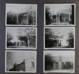
Album - Album page, Lirrewa, 1-3 Lirrewa Grove, Circa 1972
This photograph is part of the Caulfield Historical Album 1972. This album was created in approximately 1972 as part of a project by the Caulfield Historical Society to assist in identifying buildings worthy of preservation. The album is related to a Survey the Caulfield Historical Society developed in collaboration with the National Trust of Australia (Victoria) and Caulfield City Council to identify historic buildings within the City of Caulfield that warranted the protection of a National Trust Classification. Principal photographer thought to be Trevor Hart, member of Caulfield Historical Society. Most photographs were taken between 1966-1972 with a small number of photographs being older and from unknown sources. All photographs are black and white except where stated, with 386 photographs over 198 pages.From Victorian Heritage Database citation for Lirrewa - HO39 Tarqua and Stables, 1-3 Lirrewa Grove Caulfield South https://vhd.heritagecouncil.vic.gov.au/places/120932 (as at 26/10/2020) "Tarqua", now "Lirrewa", is situated at nos. 1-3 Lirrewa Grove, Caulfield South, and was built in 1886 for Montague William Langdon, son of the merchant Joseph Henry Langdon of nearby "Rosecraddock". It is historically and aesthetically significant. It is historically significant (Criterion A) as one of the Langdon family residences, comparing in Glen Eira also with "Rosecraddock" at 10 Craddock Avenue (1857) and "Hengar" at 356 Glen Eira Road (1889-90). It is aesthetically significant (Criterion E) for its capacity to demonstrate the stylistic influences prevailing at the time especially for substantial residences. At "Tarqua", the design acknowledges the prevailing popularity of the Italian Style in the shallow hipped roof form and symmetrical facade as well as the picturesque Gothic Revival style demonstrated especially by the use of pointed arches, fretted barges and the battlemented parapeted section. This latter style was particularly attractive to persons of means on account of its English precedents, the combination of influences being skillfully handled in this instance.Page 120 of Photograph Album with six photographs (all landscape) of views of Lirrewa, mostly including its garden.Handwritten: "Lirrewa" 1-3 Lirrewa Grove [top right] / 120 [bottom right]trevor hart, verandah, lirrewa, tarqua, 1880's, montague william langdon, italian style, shallow hipped roof, symmetrical facade, gothic revival, pointed arches, fretted barges, battlemented parapet, terraces, boom era, single storey, timber roof brackets, frieze, gables, cast iron ridging, lirrewa grove, cast iron work, caulfield, arches, parapets, gardens, houses, victorian style, caulfield south -
 Glen Eira Historical Society
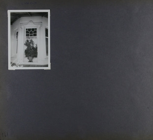
Album - Album page, Lirrewa, 1-3 Lirrewa Grove, Circa 1972
This photograph is part of the Caulfield Historical Album 1972. This album was created in approximately 1972 as part of a project by the Caulfield Historical Society to assist in identifying buildings worthy of preservation. The album is related to a Survey the Caulfield Historical Society developed in collaboration with the National Trust of Australia (Victoria) and Caulfield City Council to identify historic buildings within the City of Caulfield that warranted the protection of a National Trust Classification. Principal photographer thought to be Trevor Hart, member of Caulfield Historical Society. Most photographs were taken between 1966-1972 with a small number of photographs being older and from unknown sources. All photographs are black and white except where stated, with 386 photographs over 198 pages.From Victorian Heritage Database citation for - HO39 Tarqua and Stables, 1-3 Lirrewa Grove Caulfield South https://vhd.heritagecouncil.vic.gov.au/places/120932 as at (26/10/2020) "Tarqua", now "Lirrewa", is situated at nos. 1-3 Lirrewa Grove, Caulfield South, and was built in 1886 for Montague William Langdon, son of the merchant Joseph Henry Langdon of nearby "Rosecraddock". It is historically and aesthetically significant. It is historically significant (Criterion A) as one of the Langdon family residences, comparing in Glen Eira also with "Rosecraddock" at 10 Craddock Avenue (1857) and "Hengar" at 356 Glen Eira Road (1889-90). It is aesthetically significant (Criterion E) for its capacity to demonstrate the stylistic influences prevailing at the time especially for substantial residences. At "Tarqua", the design acknowledges the prevailing popularity of the Italian Style in the shallow hipped roof form and symmetrical facade as well as the picturesque Gothic Revival style demonstrated especially by the use of pointed arches, fretted barges and the battlemented parapeted section. This latter style was particularly attractive to persons of means on account of its English precedents, the combination of influences being skillfully handled in this instance.Page 121 of Photograph Album with one landscape photograph of Lirrewa - external view of a bay window.Handwritten: Lirrewa [top left ] / 121 [bottom left]trevor hart, verandah, lirrewa, tarqua, 1880's, montague william langdon, italian style, shallow hipped roof, symmetrical facade, gothic revival, pointed arches, fretted barges, battlemented parapet, ornamented parapets, terraces, boom era, timber roof brackets, frieze, gables, cast iron ridging, lirrewa grove, bay window, cast iron work, lead lights, houses, victorian style, caulfield, caulfield south -
 Glen Eira Historical Society
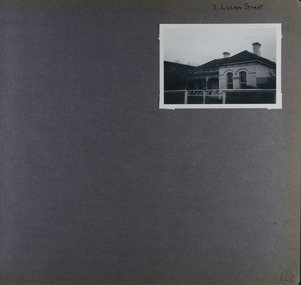
Album - Album page, Lucan Street, 7, Circa 1972
This photograph is part of the Caulfield Historical Album 1972. This album was created in approximately 1972 as part of a project by the Caulfield Historical Society to assist in identifying buildings worthy of preservation. The album is related to a Survey the Caulfield Historical Society developed in collaboration with the National Trust of Australia (Victoria) and Caulfield City Council to identify historic buildings within the City of Caulfield that warranted the protection of a National Trust Classification. Principal photographer thought to be Trevor Hart, member of Caulfield Historical Society. Most photographs were taken between 1966-1972 with a small number of photographs being older and from unknown sources. All photographs are black and white except where stated, with 386 photographs over 198 pages. Page 122 of Photograph Album with one landscape photograph of a house at 7 Lucan Street.Handwritten: 7 Lucan Street [top right] / 122 [bottom right]trevor hart, caulfield north, villa residence, verandah, terraces, timber roof brackets, gables, cast iron ridging, ornate plasterwork, arched windows, curved windows, chimneys, lucan street, victorian style, cast iron work, houses -
 Glen Eira Historical Society
Album - Album page, Malakoff Street, Circa 1972
This photograph is part of the Caulfield Historical Album 1972. This album was created in approximately 1972 as part of a project by the Caulfield Historical Society to assist in identifying buildings worthy of preservation. The album is related to a Survey the Caulfield Historical Society developed in collaboration with the National Trust of Australia (Victoria) and Caulfield City Council to identify historic buildings within the City of Caulfield that warranted the protection of a National Trust Classification. Principal photographer thought to be Trevor Hart, member of Caulfield Historical Society. Most photographs were taken between 1966-1972 with a small number of photographs being older and from unknown sources. All photographs are black and white except where stated, with 386 photographs over 198 pages. Page 126 of Photograph Album with two landscape photographs of a Victorian house.Handwritten: Malakoff Street [top right] / 126 [bottom right]trevor hart, bracketed eaves, slate roof, bay windows, decorative brackets, verandah, caulfield north, malakoff street, cast iron work, stairs, victorian style -
 Glen Eira Historical Society
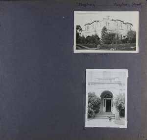
Album - Album page, Maysbury, Maysbury Avenue, Circa 1972
This photograph is part of the Caulfield Historical Album 1972. This album was created in approximately 1972 as part of a project by the Caulfield Historical Society to assist in identifying buildings worthy of preservation. The album is related to a Survey the Caulfield Historical Society developed in collaboration with the National Trust of Australia (Victoria) and Caulfield City Council to identify historic buildings within the City of Caulfield that warranted the protection of a National Trust Classification. Principal photographer thought to be Trevor Hart, member of Caulfield Historical Society. Most photographs were taken between 1966-1972 with a small number of photographs being older and from unknown sources. All photographs are black and white except where stated, with 386 photographs over 198 pages. Page 132 of Photograph Album with two photographs (one landscape, one portrait) of "Maysbury".Handwritten: "Maysbury" Maysbury Street/Avenue [top right] / 1972 Neg 47 [under top photo] / 132 [bottom right]trevor hart, windows, victorian, 1880's, maysbury, maysbury mansions, flats, decorative brackets, double storey, italianate, cast iron stair balustrading, cast iron balustrading, bay window, protruding rooms, bluestone fence, elsternwick, maysbury avenue, mansion, victorian style, arches, entrances -
 Glen Eira Historical Society
Album - Album page, Meadow Street, Circa 1972
This photograph is part of the Caulfield Historical Album 1972. This album was created in approximately 1972 as part of a project by the Caulfield Historical Society to assist in identifying buildings worthy of preservation. The album is related to a Survey the Caulfield Historical Society developed in collaboration with the National Trust of Australia (Victoria) and Caulfield City Council to identify historic buildings within the City of Caulfield that warranted the protection of a National Trust Classification. Principal photographer thought to be Trevor Hart, member of Caulfield Historical Society. Most photographs were taken between 1966-1972 with a small number of photographs being older and from unknown sources. All photographs are black and white except where stated, with 386 photographs over 198 pages. Page 134 of Photograph Album with one landscape photograph of a Victorian house on Meadow Street.Handwritten: Meadow Street [top right] / 134 [bottom right]trevor hart, east st kilda, decorative brackets, picket fence, slate roof, chimneys, garden, cast iron columns, cast iron frieze, meadow street, st kilda east, caulfield, victorian style, cast iron work, verandahs -
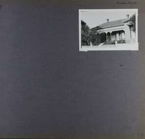
 Glen Eira Historical Society
Album - Album page, 31 Nepean Highway, Circa 1972
This photograph is part of the Caulfield Historical Album 1972. This album was created in approximately 1972 as part of a project by the Caulfield Historical Society to assist in identifying buildings worthy of preservation. The album is related to a Survey the Caulfield Historical Society developed in collaboration with the National Trust of Australia (Victoria) and Caulfield City Council to identify historic buildings within the City of Caulfield that warranted the protection of a National Trust Classification. Principal photographer thought to be Trevor Hart, member of Caulfield Historical Society. Most photographs were taken between 1966-1972 with a small number of photographs being older and from unknown sources. All photographs are black and white except where stated, with 386 photographs over 198 pages. Victorian Heritage Database - HO48 - 31 Nepean Highway Elsternwick https://vhd.heritagecouncil.vic.gov.au/places/35531 (at 15/08/2021) "Roseneath" at 31 Point Nepean Road is a bi-chromatic Italianate villa built for William Millar in 1874. It is aesthetically and historically important. "Roseneath's aesthetic value derives from its survival as a substantially intact bi-chromatic brick villa, distinguished by the symmetrical north and south facing bays and by its spacious grounds. Its historical value rests on its comparatively early date and link with Shire councillor William Millar. The choice of bi-chromatic brick, which was highly fashionable at the time, is also of note. "Roseneath" compares with "Cumbernauld" (pre 1872) at 504 Hawthorn Road and "Glenmoore" (1870) at 1 St Georges Road.Page 140 of Photograph Album with three (landscape) photographs of Roseneath on Nepean Highway. Handwritten: 31 Nepean Highway [top right] / 140 [bottom right]trevor hart, verandah, chimneys, porch, decorative brackets, single storey, cast iron columns, return verandah, garden, nepean highway, roseneath, italianate, 1870's, elsternwick, cast iron work, victorian style, polychrome bricks, william millar, slate roofs, brick houses, house names -
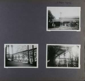
 Glen Eira Historical Society
Album - Album page, Heatherbrae, 73 Neerim Road, Circa 1972
This photograph is part of the Caulfield Historical Album 1972. This album was created in approximately 1972 as part of a project by the Caulfield Historical Society to assist in identifying buildings worthy of preservation. The album is related to a Survey the Caulfield Historical Society developed in collaboration with the National Trust of Australia (Victoria) and Caulfield City Council to identify historic buildings within the City of Caulfield that warranted the protection of a National Trust Classification. Principal photographer thought to be Trevor Hart, member of Caulfield Historical Society. Most photographs were taken between 1966-1972 with a small number of photographs being older and from unknown sources. All photographs are black and white except where stated, with 386 photographs over 198 pages.From Victorian Heritage Database citation for Heatherbrae HO46 https://vhd.heritagecouncil.vic.gov.au/places/120933 (as at 28/10/2020) "Heatherbrae" at 73 Neerim Road, Glenhuntly, is a substantial Victorian residential complex made up of two principal construction stages (pre 1876 and c. 1890) and outbuildings including stables. It is aesthetically, historically and socially significant. Its aesthetic value is demonstrated by the manner in which the two periods of construction survive, the earliest being of greater architectural interest on account of its tower and facade treatment, the latter phase adopting a common villa form. The importance of the complex is heightened by its intact state and surviving outbuildings. "Heatherbrae's" historical significance lies in its link with locally known business man and Shire of Caulfield councillor, John Charles Holland. Its social value rests on its ability to demonstrate a past lifestyle.Page 142 of Photograph Album with four photographs (three landscape, one portrait) of Heatherbrae on Neerim Road.Handwritten: "Heatherbrae" 73 Neerim Road [top right] / 142 [bottom right]trevor hart, verandah, chimneys, decorative brackets, cast iron columns, return verandah, garden, 1870's, intricate lacework, neerim road, booran road, 1880's, 1890's, mansion, john c. holland, bluestone foundations, italianate, iron roofed balcony, cast iron balustrade, balcony, ornamented pediment, mosaic tiles, cast iron lookout, flagpole, george f griffiths, mcgowan, tower, caulfield, heatherbrae, cast iron work, victorian style, john holland, porte-cochere porches, lead lights, george griffiths, mansions, stables, councillors, outbuildings