Showing 3069 items matching "scales"
-
 Eltham District Historical Society Inc
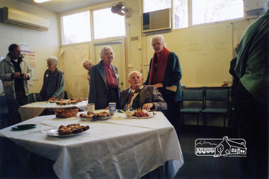
Photograph, 40th Anniversary Celebrations, Eltham District Historical Society, Eltham Courthouse, 730 Main Road, Eltham, 14 July 2007, 14 Jul 2007
The Eltham Courthouse annex was the venue for the Society's 40th anniversary celebration lunch on Saturday, 14th July 2007. Guests included: L-R: - Ron Gordon (Nillumbik Historical Society), Judy Wadham, - , Lilas Scale, Peter Bassett-Smith, Diana Bassett-SmithColour photo print 100 x 150mm40th anniversary, celebrations, diana bassett-smith, eltham courthouse, eltham district historical society, judy wadham, peter bassett-smith, 40th anniversary, celebrations, ron gordon, diana bassett-smith, judy wadham, peter bassett-smith, lilas scale, eltham district historical society, eltham courthouse annex -
 Robin Boyd Foundation
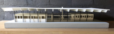
Decorative object - Model of Pelican House, Davey's Bay Victoria, 2017
This scale model of the Robin Boyd-designed Pelican house, Davey's Bay Victoria, commissioned by Kenneth and Prue Myer in 1955. This house has been demolished. This model was created for the House of Ideas exhibition, made by a University of Melbourne, Melbourne School of Design, Masters student.Model of Pelican House, Davey's Bay in Mornington Peninsula, Victoriarobin boyd -
 Nillumbik Shire Council
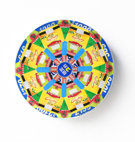
Collage: Elizabeth GOWER (b.1952 SA, AUS -), Cycles 7, 2015
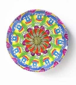
The 'Cycles' series is an extension of two large scale provisional installations '150 Rotations', Melbourne Now, National Gallery of Victoria, and '356 Rotations', AC Institute in New York, which also re-purposed and aestheticised multiple paper units into hundreds of circular motifs.The immediate tactile connection with the material excesses and detritus of contemporary consumer culture informs the theoretical framework and conceptual understanding of Gower's practice, and associates her work with ideas of recovery and re-purpose, sustainable practice and thrift strategies that critique excesses of mass production and the notion of impermanence. This series was made ‘in transit’ during the artist’s recent studio residencies at Point[B], New York and Laughing Waters, Eltham, and at three temporary studios in Rome, Berlin and Collingwood.Kaleidoscope pattern of multiple segments (logos-Lipton tea) from commercial (food) catalogues on commercial packaging (cardboard - round lid). No inscriptions and markingscycles, gower, collage, pattern, logos, commercialism, consumerism, repurpose, recycle, riverbend, laughing waters -
 Nillumbik Shire Council
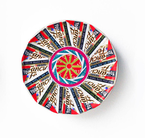
Collage: Elizabeth GOWER (b.1952 SA, AUS), Cycles 11, 2015
The 'Cycles' series is an extension of two large scale provisional installations '150 Rotations', Melbourne Now, National Gallery of Victoria, and '356 Rotations', AC Institute in New York, which also re-purposed and aestheticised multiple paper units into hundreds of circular motifs.The immediate tactile connection with the material excesses and detritus of contemporary consumer culture informs the theoretical framework and conceptual understanding of Gower's practice, and associates her work with ideas of recovery and re-purpose, sustainable practice and thrift strategies that critique excesses of mass production and the notion of impermanence. This series was made ‘in transit’ during the artist’s recent studio residencies at Point[B], New York and Laughing Waters, Eltham, and at three temporary studios in Rome, Berlin and Collingwood.Kaleidoscope pattern of multiple segments (logos-Purina 'fancy feast') from commercial (food) catalogues on commercial packaging (cardboard - round lid). No inscriptions and markingscycles, gower, collage, pattern, logos, commercialism, consumerism, repurpose, recycle, riverbend, laughing waters -
 Nillumbik Shire Council
Collage: Elizabeth GOWER (b.1952 SA, AUS), Cycles 10, 2015
The 'Cycles' series is an extension of two large scale provisional installations '150 Rotations', Melbourne Now, National Gallery of Victoria, and '356 Rotations', AC Institute in New York, which also re-purposed and aestheticised multiple paper units into hundreds of circular motifs.The immediate tactile connection with the material excesses and detritus of contemporary consumer culture informs the theoretical framework and conceptual understanding of Gower's practice, and associates her work with ideas of recovery and re-purpose, sustainable practice and thrift strategies that critique excesses of mass production and the notion of impermanence. This series was made ‘in transit’ during the artist’s recent studio residencies at Point[B], New York and Laughing Waters, Eltham, and at three temporary studios in Rome, Berlin and Collingwood.Kaleidoscope pattern of multiple segments (logos-Lipton 'Green Tea') from commercial (food) catalogues on commercial packaging (cardboard - round lid). No inscriptions and markingscycles, gower, collage, pattern, logos, commercialism, consumerism, repurpose, recycle, riverbend, laughing waters -
 Federation University Historical Collection
Photograph, Ballarat School of Mines Balance Room, c1907
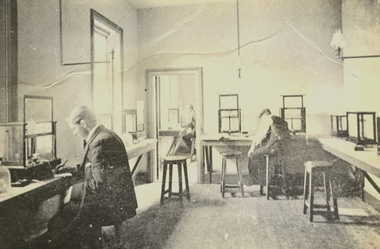
... scales ...This image was reproduced in the 1908 Ballarat School of Mines Calendar. During the early 1900s the Ballarat School of Mines had an international reputation for producing quality mining graduates. The graduates had much sought after practical experience. Their studies included 'real' experience in the Ballarat School of Mines Mining Laboratory, Assay Room, Balance Room, etc. This image was reproduced in the 1908 Ballarat School of Mines Annual Report. It is a room in the building now known as the "Old Chemistry Building'.Black and white photograph showing three men working at balances while assaying in the Ballarat School of Mines Balance Room. "Plate 117 Balance Rooms, School of Minesballarat school of mines, scientific equipment, assaying, assay, weigh, weight, scales, assay laboratory, old chemistry building, mining -
 Federation University Historical Collection
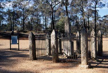
Slide, Welcome Stranger Monument, c1970
The first recorded discovery of gold in Moliagul was in September 1852 and, before long, the area was flooded with over 4,000 miners. Two of those miners, John Deason and Richard Oates, had arrived in Bendigo in 1954 seeking their fortune. After eight years of little success, the friends moved to Moliagul and pegged a puddling claim. On 05 February 1869, Deason discovered a nugget near the roots of a tree, just 3cm beneath the soil. With the help of Oates, he uncovered the largest recorded alluvial gold nugget – known as the Welcome Stranger. The 61cm x 31cm nugget was taken to Dunolly to be measured on the bank’s scales, however at 69kg the gold needed to be broken on an anvil to actually fit on the scales.Photograph of the monument for the Welcome Nugget, a large gold nugget found by John Deason and Richard Oates at Moliagul.Obelisk inscription Welcome Stranger Nugget On this spot the largest nugget of gold in the world was discovered on the 5th February 1869 by John Deason and Richard Oates. Weight 2316 oz, Value £9553 Erected by the Mines Department 1897 Henry Foster Minister of Mines, D. J. Duggan M.L.A. Member for Dunollywelcome nugget, welcome nugget monument, john deason, richard oates -
 Flagstaff Hill Maritime Museum and Village
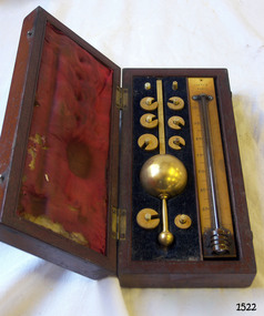
Instrument - Hydrometer, J Long (Joseph Long), late 19th - early 20th century
This Sike’s Hydrometer was donated by the Port Fairy Customs Office as it was no longer required by them due to a change in the law. The hydrometer was part of a system for Ullaging or calculating the amount of liquid remaining in a container of liquor such as a barrel, and the amount of alcoholic content in the contents. It can also measure the free space or head space remaining. Hydrometers were used to measure the density, or relative density, of liquids from the late 1600s. In 1816 Bartholomew Sikes won the competition for the most useful accurate hydrometer. Hydrometers were commonly used by distillers, vintners, and brewers to establish accurate measures of alcohol concentration in their beverages. Following this manufacturing process, government inspectors and excise officers used them to check that the labelled indications of alcohol-proof were correct and that the right amounts of duty were being paid.The Sikes hydrometer is of local significance because of its association with the Government's Customs Office in Port Fairy, in the southwest region of Victoria. It is also associated with Bartholomew Sikes, whose design of a hydrometer was chosen in 1816 as being the most useful and accurate hydrometer. The hydrometer has evolved into the digital version available today to measure density of liquids.Sikes Hydrometer and thermometer in a fitted wooden case with crimson lining inside the lid and dark lining in the base. The case has ten vertical pegs to secure the weights. The brass hydrometer has a spherical float and eight thick brass horseshoe-shaped weights. The serial number is on each section of the float and all weights. Both sides of the float’s upper flat stem have a scale from 0-10, with five divisions between each number. The eight weights are numbered from 20 – 90 in increments of 10. The set includes a mercury thermometer mounted on an ivory back plate labelled with Fahrenheit and Centigrade Scales. The Sikes hydrometer set was made by Loftus of London. The hydrometer model is IID 510, Serial Number is 14674, calibrated by Longs, London. All parts of the float and eight weights are inscribed with Serial Number “14674” The float stem is stamped "SIKE'S IID 51o” Calibrator, "LONG LITTLE TOWER ST LONDON" The weights are numbered individually ”20”, “30”, “40”, “50”, “60”, “70”, “80” or “90” Each weight in inscribed; symbol “(J L) [inside an ova, with textured background]” The thermometer inscribed: “LOFTUS OF LONDON”flagstaff hill, warrnambool, shipwrecked coast, flagstaff hill maritime museum, maritime museum, shipwreck coast, flagstaff hill maritime village, great ocean road, measuring instruments, customs tax, weighing instrument, sike’s hydrometer, calibrator long of london, loftus of london instrument maker, loftus, j long, sikes hydrometer, scientific instrument, pressure measurement, measuring instrument, ullage tool, customs, excise duty, tax, alcohol content, proof, calibrate, standard weights and measures, tariff, scientific instrument makers, specific gravity, liquid density, alcohol testing, technology, alcohol measurement, proof spirit, wine and spirits merchants, local business, brass measuring instrument, port fairy, customs office, port fairy customs, joseph long, instrument maker -
 University of Melbourne, Burnley Campus Archives
Plan, Orchard/Field Station, 1983 - 1992
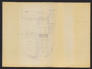
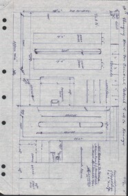
(3) Used by Linda Hipwell for her Honours Thesis.Plans of the Orchard later known as the Field Station. (1) Copy, "Drawing: Orchard Site Plan." Each section labelled. (2)Tracing paper, 2 paper copies and 3 enlargements, "VCAH Burnley Field Station Plan," some printed labelling and some in pencil. 1992.(3) "VCAH Burnley Field Station Proposed Redevelopment," drawn by MG July 1992. (4) Tracing paper copy, Site Plan of Orchard by Alexander Metherell Pty. Ltd. Job No BHC/1 drawing No SP/2 Dec 1983. Scale 1:500. (5) Plan on tracing paper, includes Energy Education Centre. (6) Plan on tracing paper, includes Energy Education Centre. Scale 1:500. Also see B15.0352 Full Report. orchard, field station, linda hipwell, alexander metherell -
 Lakes Entrance Historical Society
Administrative Record - Ledger, Poundkeepers Book, 20302
Entries are hand written in ink, pages 1 to 31 have been used, pages 31 to 97 are blank, Scale of Charges taped to inside cover, records across both page and facing page, 97 numbered leaves, leather bound with heavy cardboard coverA ledger containing details of animals impounded by Swan Reach pound during period December 1926 to 1955accounts book -
 Bendigo Military Museum
Equipment - VICKERS CLEANING KIT, HERFORDS PTY. LTD, 1941
Item belonged to Maxwell Lennox Matheson No 418447 RAAF. Refer Cat No 1959 for his service record.Cleaning kit for a Vickers Machine Gun 1) Leather "wallet" for the kit 2) Brass inspection mirror, with cap, for the use of checking barrels. 3) Oil can tin 4) Oil brush, set into the brass cap of oil can 5) Gauge tension, with flat blade one end and bullet shape other end 6) Screwdriver, flat blade, wooden handle 7) Leather pouch with strap1) Front marked "303 INCH VICKERS" 5) Marked "0 - 20" scale 7) Front marked "D.D 303 VICKERS GUN E.B", rear marked "MADE BY RE BOWDEN & SON LTD. (indistinguishable) ST, NEWTOWN NSW 1942" handcrafts - leatherwork, metalcraft brassware, trades-tools, military history, vickers -
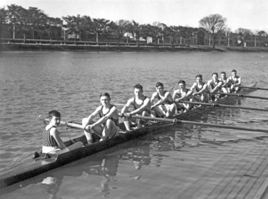 Power House Rowing Club
Black and white photograph, The Sears Studio St Kilda, PHRC Novice VIII, 1936
Digital scan of framed black and white photograph.J Barton Jnr (cox) I Scales (Str) N West (&) J Chadwick (6) J Fuller (5) D Stewart (4) L Orr (3) D Garside (2) E Campbell (Bow) J Barton Snr (Coach) -
 Eltham District Historical Society Inc
Photograph, 40th Anniversary Celebrations, Eltham District Historical Society, Eltham Courthouse, 730 Main Road, Eltham, 14 July 2007, 14 Jul 2007
The Eltham Courthouse annex was the venue for the Society's 40th anniversary celebration lunch on Saturday, 14th July 2007. L-R: - Ron Gordon (Nillumbik Historical Society), Lilas Scale, Peter Bassett-Smith, Diana Bassett-Smith, Vicki Court (Royal Historical Society of Victoria)Colour photo print 100 x 150mm40th anniversary, celebrations, ron gordon, lilas scale, peter bassett-smith, diana bassett-smith, vicki court, eltham courthouse annex, eltham district historical society -
 Ballan Shire Historical Society
Map - Map. Ballark, Department of Lands and Survey, Ballark. County of Grant, 31/08/1915
A map of the Ballark area within the County of Grant showing roads, waterways, property boundaries and property owners in 1915.Significant to people researching land usage and ownership. Also those researching families in the area at that time.A map of Ballark in the County of Grant. Black printing on buff coloured paper. Extra notations by hand and various coloured highlighting of certain features. Details roads, rivers, property boundaries and names of property owners and districts. The map is easily readable although there is some physical damage to the borders and some sellotape residue. Shows a scale in Chains and the number L.6030Various numbers and directional arrows added to map.bungal, borhoneyghurk, bungeeltap, ballark, beremboke, moreep, meredith, morrisons, moorarbool river -
 Ballan Shire Historical Society
Map - Map. Bullarook State Forest, Bullarook State Forest Reserve
A small map of the Bullarook State Forest Reserve. Drawn on a fine buff coloured paper attached to a stiff cloth backing sheet. The title is hand written and includes a "scale one mile to one inch" hand written also. The map is signed "John Wrigglesworth, assistant ? and dated 26/6/1869" although the month and year are almost illegible.moorabool west, state forest, bullarook, eastern moorabool river, werribee river, moorabool east, blakes saw mill, wombat, andersons saw mill -
 Warrnambool and District Historical Society Inc.
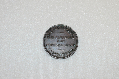
Coin - Token, W.W. Jamieson Store token
William Wilson Jamieson came to Warrnambool around 1857 after running a Ironmongers business in Hawthorne died . He opened his store in Liebig St which he operated until his death in 1882. He was quite active in the community serving on the town council for a number of years and also the Oddfellows Lodge and the Mechanics Institute. He came to Warrnambool in 1857, after running an Ironmonger's business in Hawthorn and having worked for the hardware company McEwan & Co. in Melbourne. He bought a weatherboard building that had previously been a 'bowling saloon' in Liebig Street and opened a business that Gardner describes as a general store and Turnbull describes as a drapery store. He was a member of the town council from 1862 to 1874 and from 1877 to 1880 and also served as mayor for two terms. He was also active in community organisations including the Mechanics institute and the Oddfellows This token is of great importance. It is significant for three reasons: 1. It is an example of an 1850s Australian token, demonstrating an early business practice in our history. 2. It is an example of a Warrnambool token produced by an important Warrnambool business (only two firms in Warrnambool produced tokens)A round copper token. The token was issued by: W.W. Jamieson & Co.. Liebeg St. Warrnambool, Storekeepers 1862 which is in raised lettering on the obverse of the token. The reverse features a blindfolded woman with the scales of Justice in her raised right hand. She is standing beside the seashore with a sailing ship in the background AUSTRALIA is stampedabove the figure anf the date 1862 is stamped below.W.W. JAMIESON & CO STOREKEEPERS LIEBEG STREET WARRNAMBOOL. AUSTRALIA1862jamieson token, warrnambool, william wilson jamieson, warrnambool ironmonger -
 Bendigo Military Museum
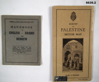
Booklet - HANDBOOK & ROAD MAP, April 1940
Sold by Ringarts Bookshop, Haifa1. This is a small pocket book, grey cover, black ink printing. It has words and phrases of colloquial Arabic and/or Hebrew. 32 pages. It is for Australian Imperial Forces in the Middle East. 2. Palestine Road Map. It has cardboard cover and opens out to a road map, scale 1:500,000. It has a drawing of the old section of Jerusalem on front cover.passchendaele barracks trust, 1. nr9430t, 2.9431t, ww2 -
 Federation University Historical Collection
Photograph - Art class photograph, Drawing from the Antique, 1920, c1920
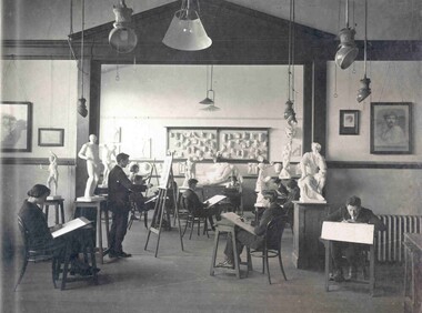
The large plaster Illisos depicted in the back of this image is still held by Federation University Australia. The Ballarat Technical Art School (No. 10) was part of the Ballarat School of Mines and was established in 1907. After conducting classes in various locations around Ballarat a custom built art school was erected on the site of the former Ballarat Circuit Court House, previously used as the initial building of the Ballarat School of Mines. Examples of drawings undertaken by students, as well as some plaster castes are held in the University of Ballarat Historical Collection. The Ballarat Technical art School is the oldest continuous Tertiary Art School in Australia. Sir Alexander Peacock opened the new Ballarat Technical Art School building in July 1915. It cost 10,000 pounds and was constructed by the Public Works Department from plans drawn by the then Art School Principal, Herbert H. Smith. The building contractors were Messrs Gower and Eddards. According to the SMB Annual Report of 1914 'the internal upholstering and fittings have all been carried out in Australian timbers, with Queensland maple largely used throughout.' The building could be described as federation-art deco in style. It features sandstone insertion with sandstone string coursing. The base of the building is rusticated sandstone. The building is functional in design with large metal windows in the south wall to ensure good light into the studios. The northern wall has standard double hung windows. The interior of the building features a carved wooden staircase and cast iron ceiling vents. The rear drawing studios could be made into one large studio by opening panelled timber doors. This opening features classical plaster pilasters with a pediment above. (http://guerin.ballarat.edu.au/curator/buildings/technical_art_school.shtml) Black and white mounted photograph showing eleven students of the Ballarat School of Mines Technical Art School drawing from plaster models of human bodies in various poses and of various scales. The students are in a room of the Ballarat Technical Art School which was custom built for teaching art. The image was reproduced in the 1920 Ballarat School of Mines Students' Magazine. drawing, ballarat school of mines, ballarat technical art school, art studio, plaster caste, gribble building, illisos, hercules, drawing from the antique, visual arts -
Federation University Historical Collection
Book, Glenfine South and South Berry Journal
This Book is associated with former Ballarat School of Mines Student Richard Squire (1875-1876). Gift of the Squire FamilyGreen water marked linen covered journal with maroon spine with red feint lined blue pages. Label on front cover is cream with black printing JOURNAL with handwritten DATA RISIS GLENFINE SOUTH -SOUTH BERRY G.S & S.B Hand written in black and red ink. Plan in back with scale 20 chains to one inch - Has an index. Handwritten on title page in black ink Address of sawmiller T. J. Brown, Mount Rowan D. W. Hambly 317 Ligar St, Ballarat J. Freeman, C/O Mrs H Simons, Lynch St, Footscray Sleemans Prescription for the bladder in 19009 Mixture No 55983 Tabloids No 55982glenfine south, south berry, sleemans, mining, gold mining, glenfine consols, reef, weights of quartz, blacksmiths tools, australian and eagle, davies south east reef drive, brawns, eaglehawk junction, simons letter, machinery, puddlng plant, poppet heads, winding plant, creswick, mosquito creek, frenchmans gully, spring hill, a. h. welsh, squire, petticoat gully -
 Bendigo Historical Society Inc.
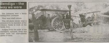
Newspaper - JENNY FOLEY COLLECTION: JOHNSON FAMILY
Bendigo Advertiser '' The way we were'' from Wednesday, March 3, 2004. The Johnsons were a family hailing from Leichardt. They were chaff cutters. This old photo shows what is presumed to be members of the Johnson family at work on the family farm. Judging from the scale of the machinery captured, there was some hard toil undoubtedly ahead of them. The clip is in a folder.newspaper, bendigo advertiser, the way we were -
 Bendigo Historical Society Inc.
Document - CENTRAL DEBORAH GOLD MINE - PLAN OF CHANGING HOUSE
Hand drawn plan for Changing House for Central Deborah G. M. Co. Bendigo. Drawn by A. Richardson 14/11/1971. Drawing has approx. measurements and is not drawn to scale. Also some Central Deborah Gold Mine Information . Ref. Mines Dept. Surface Plan 15/1/1954. Written by A Richardson 14/12/1971.mine, gold, central deborah gold mine, central deborah gold mine, plan of changing house, a richardson, mines dept. surface plan 15/1/1954 -
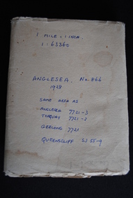 Anglesea and District Historical Society
Map, Royal Australian Survey Corps, Anglesea, Victoria, 1954
Anglesea, Victoria [cartographic material] produced by Royal Australian Survey Corps. Colour; Scale [1:63,360] 1 mile to 1 inch; transverse Mercator projection; Sheet No. 866, Zone 7. Two stamps: 1. Rankine and Dobbie Pty Ltd. 2. Authorised for sale / Price 2/- / By Department of the Army Original date: November 1928.(See above)anglesea map, topographic map -
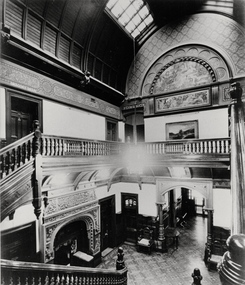 Kew Historical Society Inc
Photograph - Central Hall, 'Tara Hall', Studley Park Road, Marc Strizic, c.1960
'Lost Glories: a memorial to forgotten Australian buildings' was published by David Latta in 1986. It tells the story of a number of significant Australian buildings that had previously been demolished. A chapter in the book was devoted to Goathland, later known as Tara Hall. To supplement the text, he sourced photographs from a range of suppliers, chiefly the Royal Women's Hospital which had once owned Tara Hall, but had sold it in 1960. This is one of the photographs donated to KHS by the author.Central Hall, Tara Hall, circa 1957. The central hallway and grand staircase of Tara Hall (previously named Byram, Goathland and Lowan). This photograph provides the clearest evidence of the scale and building materials selected by Edward George Kilburn, of Ellerker & Kilburn, for the industrialist George Ramsden in 1888. These include the murals on the second floor, the use of skylights, and the vaulted wooden panelling. byram, goathland, tara hall, lowan, studley park (kew), george ramsden, sir malcolm mceacharn, edward george kilburn (architect), studley park road (kew) -
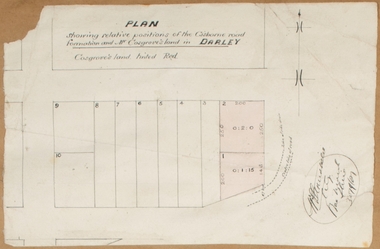 Bacchus Marsh & District Historical Society
Map, Plan showing relative positions of the Gisborne road formation and Mr. Cosgrove's land in Darley. 1907
No background information about the roadworks referred to in this plan has been found. The portion of land referred to as 'Cosgroves' in this plan is located close to the present day Darley Park Recreation Park in Darley, near Bacchus Marsh. The land indicated appears to be close to the corner of Grey Street and Gisborne Road. James Cosgrove who died in 1923 aged 65 owned a farm of 52 acres in this area of Darley.Single page map showing a proposed deviation of the Gisborne road in Darley and its position relative to land owned by Mr. Cosgrove. The land owned by Cosgrove is shaded in pink. No scale indicated. Part of a set of maps which are pasted into a bound volume containing 76 maps or plans in total. High resolution digital image stored on BMDHS computer network. Signature (illegible), Eng, Bac Marsh Shire, 30/9/07bacchus marsh roads and streets, darley victoria maps -
 National Vietnam Veterans Museum (NVVM)
Instrument - Plotting Board, M16
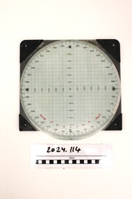
Standard issue item as used by Australian servicemen during the conflict in Vietnam. A plotting board is a mechanical device used as part of a firing control system to track the observed course of a target, project its future position, and derive the azimuth (or direction) and range needed to direct the fire of the guns of a battery to hit that target.White plastic base. A circle marked with grid lines is printed on the base and a vernier for finding azimuth deflections in along top edge. Rotating disc pivots at the centre atop the disc with distances measured radially form 0 at the centre to 3400 metres around the rim range form 0-6400 metres. A scale pivoted at the centre assists in reading distances.Nth and Sth top and bottom on rotating disc. East and West in centre distances in black on outer of disc. Distances in green on inner North, South, East, West. Varn W left bottom of disc. varn E on right bottom of disc.plotting board, m16 -
 Melbourne Tram Museum
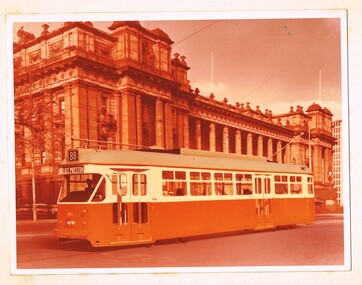
Photograph - Colour photograph - mounted, Melbourne & Metropolitan Tramways Board (MMTB), c1973
Block mounted colour photograph - faded or excessive amount of orange in the printing of prototype tramcar 1041 with Parliament House in the background. Montaged photo of the tram onto the scene - destination of East Preston not to scale, driver - a "cardboard cutout" - no conductor, though the seat is shown. No tramcar number. Front of tram with headlight and marker lights not as built but as shown in some drawings and the model.trams, tramways, 1041, prototype tramcar, spring st, parliament, tram 1041 -
 Bendigo Historical Society Inc.
Document - MARKS COLLECTION: STRATHFIELDSAYE PLAN 1854
Plan drawn on light paper. Written on LH side of plan 'Plan of Part of the Parish of Strathfieldsaye 1854. Scale (shown) Lithographed at the Surveyor Generals Office, Melbourne July 10th. By I. Jones'. Plan shows Emu Creek and Village Reserve at top of plan, Shepherd's Creek on RH side, Parish Boundary Line on RH and bottom of plan.map, bendigo, shire of strathfieldsaye 1854 -
 National Vietnam Veterans Museum (NVVM)
Manual, Australian Army: Repair Parts Scale 02088, 2320-66-096-4511. Truck, Utility, Lightweight, MC2, 4x4, 6 Cyclinder Petrol Engine, Manual Transmn, 12V Elec System: Landrover Series 3
Wrapped in paper with a white label on the front which reads Australian Army: Repair Parts Scale 02088, 2320-66-096-4511. Truck, Utility, Lightweight, MC2, 4x4, 6 Cyclinder Petrol Engine, Manual Transmn, 12V Elec System: Landrover Series 3. Above this is the Australian Army Insignia with Australian Army typed under this.australia - armed forces - service manuals, australian army, landrover series 3 -
 Bendigo Military Museum
Photograph - Detachment - Army Survey Regiment, Bonegilla, Victoria, c1973
This is a set of six photographs of personnel from the Detachment - Army Survey Regiment taken in front of its main map production building at Bonegilla, Victoria in c1973. This cartographic map production sub-unit of the Army Survey Regiment operated in buildings owned by the School of Military Survey from 17th of June 1970 to the 30th of September 1985. A total of 800 topographic maps ranging in scale from 1:25,000 to 1: 250,000 scale were completed. A major focus of production in the 1970s was the cartographic completion of the Papua-New Guinea 1:100,000 map series and the Flexiflow quality control system was developed as a tool to coordinate production. The Flexiflow system comprised a series of job plans and charts linked to a task allocation to resource magnetic planning board. Using critical path analysis and task prioritisation, complex job planning was efficiently scheduled, and re-prioritisations readily made. Reproduction requirements were effectively coordinated by way of weekly courier to the Army Survey Regiment at Bendigo. Supervisors and technicians fully embraced the system as they could understand their role, others around them and the positive production achievements. WO1 Bill Boyd (who does not appear in this photograph) was the technical warrant officer for 11 years at the Detachment was awarded the OAM, the Order of Australia Medal for leading the development and the implementation of the Flexiflow system. By mid-1982, production of maps at these scales was undertaken digitally on Bendigo’s AUTOMAP 2 system and the Detachment reverted to production of small-scale large format RAAF aeronautical charts. Detachment personnel managed to produce 18 charts in the following two years, which was an impressive achievement for the staff, given major differences in format, specification and scales. Development of digital production of aeronautical charts in 1984-85 led to gradual reduction in production output and contracting out production was instigated to meet the shortfall and as a consequence the Detachment closed in September 1985. See pages 177 to 180 of Valerie Lovejoy’s book 'Mapmakers of Fortuna – A history of the Army Survey Regiment’ ISBN: 0-646-42120-4. for more information on the history of the Detachment at Bonegilla.This is a set of six photographs of the Detachment - Army Survey Regiment taken in front of the main map production building at Bonegilla, Victoria in c1973. The photographs were printed on photographic paper and are part of the Army Survey Regiment’s Collection. The photographic print and proofs were scanned at 600 dpi. .1) to .3) - Photo, black & white c1973. Back Row L to R: Peter Simpson, Chris Edwards, unidentified (x2), Colin Harden, Rowan Gillies, Bob Rowley OAM, Steve Hansen, Stu Thaxter. Centre Row L to R: Kevin Boehm, Dennis McCarthy, Peter Cross, unidentified, Brian Ryan, unidentified, Ian Marner, unidentified, Phil Smalley. Front Row L to R: Geoff Haynes, Bruce Wetzig, Dave Thompson, unidentified, OC Bob Roche, Ike Lever, John McCulloch, Dick Barwald, unidentified. .4) - Photo, black & white c1973. Back Row L to R: Peter Simpson, Chris Edwards, unidentified (x2), Colin Harden, Rowan Gillies, Bob Rowley OAM, Steve Hansen, Stu Thaxter. Centre Row L to R: Kevin Boehm, Dennis McCarthy, Peter Cross, unidentified, Brian Ryan, unidentified, Ian Marner, Phil Smalley, unidentified, Dick Barwald. Front Row L to R: Geoff Haynes, Bruce Wetzig, Dave Thompson, unidentified, OC Bob Roche, Ike Lever, John McCulloch, unidentified (x2). .5) - Photo, black & white c1973. Back Row L to R: Geoff Haynes, unidentified, John McCulloch, Bruce Wetzig. Front Row L to R: Dave Thompson, Ike Lever, unidentified. .6) - Photo, black & white c1973. L to R: OC Bob Roche, unidentified.There are no personnel annotated.royal australian survey corps, rasvy, army survey regiment, detachment - army survey regiment, army svy regt, asr -
 Bendigo Military Museum
Administrative record - Funds for New Air Photograph coverage of (Australian) Training Areas, DMT, 26 June 1960
This document is the justification for additional funds to acquire new air photography coverage of Australian Defence Training areas as existing air photography was out of date and the scale of the photography was unsuitable. RAAF was incapable of flying the required photography and contractors were required to complete the task. This is the justification for additional funds for the task.2 x poorly photocopied A4 page minute dated 1960royal australian survey corps, rasvy, fortuna, army survey regiment, army svy regt, asr