Showing 2154 items
matching 1921
-
 Stawell Historical Society Inc
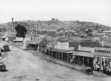
Photograph, Streetscape of South side of Upper Main Street Reefs Stawell looking East from around Patrick Street corner with Big Hill Mining in background c 1867
Upper Main Street east of Patrick street, looking East c 1867 with Big Hill Mining in Background. J McGee's Shamrock Hotel. Jennings Western Turf Hotel. R Lorimer & Co. Photo c 1867 McGees Shamrock Hotel centre. R. Williams Dining Rooms, Jennings's Western Turf Hotel. Situated in upper Main Street (Opposite Monaghan's Estate Office) Mr. George Jennings was proprietor until the late 1860's when he went to live at "Mayo Park" Lubek. The Hotel had Various owners until it was delicensed in 1909 and became a boarding house. It was demolished in 1921. R. Lorimer & Co general Store near corner of Patrick Street.Streetscape of South Side of Main Street East of Patrick Street. Two wagons in street. Showing J. McGees Shamrock Hotel, R Williams Dining Rooms, Jennings's Western Turf Hotel and R. Lorimer & Co. Mine Engine Chimney is on left of photo. Big Hill in Background with Waterloo Reef Company Whim at centre.stawell streetscape -
 Wodonga & District Historical Society Inc
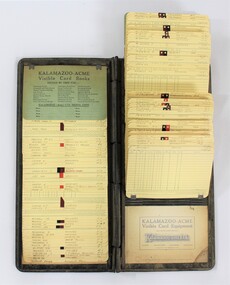
Financial record - Kalamazoo - Acme Visible Card Book used in the J. Mann & Sons General Store in Wodonga, c. 1930s
Part of the 'Mann' collection in the Wodonga Historical Society, used for accounting in the J. Mann & Sons General Store in High Street, Wodonga in 1934-35. J. Mann and Sons was first established as a farm produce store in 1921. The range of products was extended in the 1930s and included groceries and hardware, as well as the first petrol bowser in Wodonga outside the store. After WWII, the premises were extended and the range of products continued to increase. In the 1960s the Mann Family opened a new supermarket in Wodonga, in addition to the hardware business, providing steel, plumbing and industrial supplies, and they employed over 100 people at one stage. With changes in the retail industry, the Mann Family sold the main hardware business to Bunnings and the produce business to the Kelly brothers in 2006. Local significance due to its use in the J. Mann & Sons General Store in High St, Wodonga and association with the prominent Mann family. National significance as kalamazoos were manufactured by an Australian company and used in the 1930s for accounting purposes by local businesses.Visible card book or kalamazoo used by the accounts department of J. Mann & Sons General Store, High Street, Wodonga, in 1934-35 for customers with surnames from K to P.Details for each customer provided on individual cards. "KALAMAZOO - ACME / Visible Card Equipment / THE "RAPID SIGHT" METHOD / Kalamazoo (AUST.) LTD. / SYDNEY - MELBOURNE - BRISBANE - ADELAIDE"mann, accounting, financial record, high street wodonga, wodonga, commerce, business, kalamazoo, general store, j. mann & sons -
 Wodonga & District Historical Society Inc
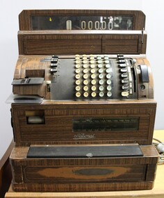
Functional object - National cash register used in the J.Mann & Sons General Store in Wodonga
The National cash register was used in the J. Mann & Sons General Store in High St., Wodonga, Victoria, and is part of the 'Mann' collection in the Wodonga Historical Society. J. Mann and Sons was first established as a farm produce store in 1921. The range of products was extended in the 1930s and included groceries and hardware, as well as the first petrol bowser in Wodonga outside the store. After WWII, the premises were extended and the range of products continued to increase. In the 1960s the Mann Family opened a new supermarket in Wodonga, in addition to the hardware business, providing steel, plumbing and industrial supplies, and they employed over 100 people at one stage. With changes in the retail industry, the Mann Family sold the main hardware business to Bunnings and the produce business to the Kelly brothers in 2006. The National cash register has local significance due to its use in the J. Mann & Sons General Store in High St, Wodonga and the association with the Mann family. National cash register used in the J. Mann & Sons General Store in High St., Wodonga, Victoria. It has a metal exterior with faux wood grain and there is a grey electrical cable attached to the proper left side."National" "U 5044298 / CL6136 16R&S10" on a small rectangular metal plate on the front of the cash register.cash register, national cash register, mann, high street wodonga, local business, commerce, general stores, j. mann & sons -
 Wodonga & District Historical Society Inc
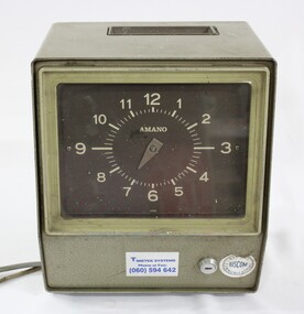
Functional object - Amano Time Clock used in the J. Mann & Sons General Store in Wodonga, c. 1960s
Part of the 'Mann' collection, used for time keeping by employees in the J. Mann & Sons General Store in Wodonga High Street in the c 1960s. J. Mann and Sons was first established as a farm produce store in 1921. The range of products was extended in the 1930s and included groceries and hardware, as well as the first petrol bowser in Wodonga outside the store. After WWII, the premises were extended and the range of products continued to increase. In the 1960s the Mann Family opened a new supermarket in Wodonga, in addition to the hardware business, providing steel, plumbing and industrial supplies, and they employed over 100 people at one stage. With changes in the retail industry, the Mann Family sold the main hardware business to Bunnings and the produce business to the Kelly brothers in 2006. The Amano time clock has local significance due to its use in the J. Mann & Sons General Store in High St, Wodonga and the association with the prominent Mann family.Green metal electronic Amano time clock used by employees in the J. Mann & Sons General Store in Wodonga, with a brown clock face and light coloured numbers. Two labels on the lower part of the front surface with a horizontal lock between them, and a small metal plate on the proper left side with the model and serial numbers, plus "S 422" written in black marker below. Slot in the top surface of the time clock for the employees' time cards."AMANO" - on the clock face "TIMETEK SYSTEMS / Phone or Fax: / BU..NESS / BISCOM / COMMUNICATIONS" - on the lower front "Model 6733 Serial No 23229 / Volts /240 / Watts 5 / Hz 50 / AMANO CORPORATION / MADE IN JAPAN / S 422" - on the lower proper left sidemann, general store, wodonga, time clock, commerce, local business, high street, j. mann & sons -
 Wodonga & District Historical Society Inc
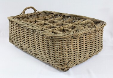
Functional object - Wicker Crate for Delivering Drinks - J. Mann & Sons General Store
The wicker crate for delivering drinks was used in the J. Mann & Sons General Store in High St., Wodonga and is Part of the 'Mann' collection in the Wodonga Historical Society. J. Mann and Sons was first established as a farm produce store in 1921. The range of products was extended in the 1930s and included groceries and hardware, as well as the first petrol bowser in Wodonga outside the store. After WWII, the premises were extended and the range of products continued to increase. In the 1960s the Mann Family opened a new supermarket in Wodonga, in addition to the hardware business, providing steel, plumbing and industrial supplies, and they employed over 100 people at one stage. With changes in the retail industry, the Mann Family sold the main hardware business to Bunnings and the produce business to the Kelly brothers in 2006. The wicker crate for delivering bottled drinks has local significance due to its use in the J. Mann & Sons General Store in High St, Wodonga and the association with the prominent Mann family in Wodonga.Rectangular wicker crate with 12 individual compartments and handles at each narrow end, used in the J. Mann & Sons General Store for delivering bottled drinks. Two wooden slats extending the length of the underside to provide structural support.drinks basket, mann, j. mann & sons, general store, high street, wodonga, commerce, local business -
 Wodonga & District Historical Society Inc
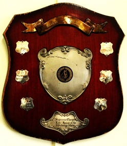
Award - Mann's of Wodonga Supreme Champion Led Horse Shield
In a "LED HORSE" category, the horse is presented bridled and unsaddled. The handler leads the horse in clockwise direction on the circle. The horse is required to walk and trot and stand to be judged. The judge looks for correct conformation of the horse as well as ahorse that is neatly presented and in good condition. Straight movement, correctness and quality of paces and obedience of the horse are also taken into consideration. This trophy was sponsored by Manns of Wodonga. The Mann family operated a major business in Wodonga for 85 years, beginning with a produce store in February 1921. It expanded to become one of Australia’s largest regional shopping centres, with a Supermarket, Hardware Store, Steel Store, Plumbing and Industrial supplies store, at one stage employing well over 100 people. The Mann Family sold the business in 2006.This item has local significance as it records winners in equestrian events at the Wodonga Show. The award was also presented by a prominent citizen of Wodonga.A wooden shield with metal plaques engraved with names and year of competition winners for the Supreme Champion Led horse at the Wodonga Show.On gold toned banner at top: "Manns of Wodonga" On bottom plate: Supreme Champion/ Led Horse of / the Wodonga Show" On smaller shields: "1976/MISS M McINTYRE/ GREEN VALLEY/CALYPSO", "1977 /MISS M McINTYRE/BIRRAHLEE LONICERA" , "1978/J. VINGE/ HILLINVIEW/BLACK PANTHER" , "1979/MRS A. WILKINSON/SWEET SUE"equestrian events wodonga show, wodonga show, supreme champion led horse, mann wodonga -
 Flagstaff Hill Maritime Museum and Village
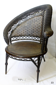
Furniture - Chair, 1855-1900
Heywood & Wakefield Furniture Co: The Heywood-Wakefield Company is an American furniture manufacturer established in 1897 that went on to become a major presence in the US. Its older products are considered collectibles and have been featured on television antique programs. The Heywood brothers established themselves in 1826, as furniture makers and the Wakefield Company began in 1855 as a separate company. Both firms produced wicker and rattan furniture, and as these products became increasingly popular towards the end of the century, they became serious rivals. In 1897 the companies merged as Heywood Brothers & Wakefield Company (this name was changed to Heywood-Wakefield Company in 1921), purchasing Washburn-Heywood Chair Company in 1916, Oregon Chair Company in 1920, and Lloyd Manufacturing Company in 1921. While its wooden furniture plant in Gardner, Massachusetts closed in 1979, a branch in Menominee, Michigan continued to manufacture metal outdoor seats, auditorium seats, and school furniture. The Heywood-Wakefield Company Complex in Gardner was added to the National Historic Register in 1983. The South Beach Furniture Company acquired the rights to the name in 1994 and reproduces its wooden furniture. Both founding companies produced wicker and rattan furniture in the late 19th century. The wicker styles drew on the Aesthetic Movement and Japanese influences simpler designs arose in the wake of the Arts and Crafts Movement. The merged entity stayed abreast of wicker furniture trends by hiring designers such as Paul Frankl and Donald Deskey during the 1920s. Its furniture was exhibited at the 1933 Century of Progress exhibition and the 1964 New York World's Fair. During the 1930s and 1940s, Heywood-Wakefield began producing furniture using sleek designs based on French Art Deco.The chair has social significance at a local level, because it illustrates the level of material support the Warrnambool community gave to Flagstaff Hill when the village and Museum was established. The wicker nursing chair is a fine example of late 19th century light weight domestic furniture that today are very collectible items and quite rare and valuable.Nurse wicker chair, wood, cane and rattan with round rushed seat. The one left arm being that to support the infant during feeding. 1870s-1890s. Believed to have been made by Heywood Brothers & Wakefield Company, USA. flagstaff hill, warrnambool, flagstaff hill maritime museum, shipwreck coast, great ocean road, 19th century furniture, rolled serpentine wicker work, cane armchair, classic wicker furniture, victorian style furniture, domestic furniture late 19th century, heywood-wakefield company, feeding chair, nursing chair, mother's chair, nursery furniture -
 Federation University Historical Collection
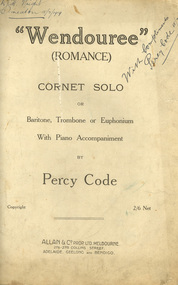
Booklet - Sheet Music, Allan & Company Pty Ltd, "Wendouree", Romance by Percy Code, 1919
This music was used by Frank Wright who had been tutored by Percy Code. Frank Wright won the Australian Open Cornet Championship using this music, and won the gold medal for the highest mark in the British Colonies. Percy Code was born in Melbourne on 03 July 1888. He started learning the violin and piano at the age of eight. Three years later his father, Edward, started tutoring him on the cornet. His first competition was in October 1902 in Ballarat's South Street Competitions. Percy Code was Musical Director of Ballarat City Brass Band from 1913 until 1921. He was Frank Wright's teacher. Code apparently lived in a large house just west of where St Peter's church (Ballarat) now stands. Percy Code toured the world as principal cornet with the 'Besses o' th' Barn Band.' He returned to Australia in 1912. Frank Wright at one stage rode his pushbike from Smeaton to Ballarat for lessons. Leaving Australia for America in March 1921 Percy Code obtained an appointment as trumpet soloist for the 70 piece San Francisco Symphony Orchestra. He returned home two years later and became bandmaster to the Prahran City Band in 1925. From 1938, as part of Australia's Sesqui Centenary celebrations, Percy Code conducted the Sydney Symphony Orchestra for the ABC orchestral concerts in Sydney Town Hall. His career with the ABC came to an end in late 1951 due to poor health. Percy Code died on 17 October 1953. From 'Legend in Brass' with additions from Bob Pattie of the Ballarat Brass Band.11071.1 Four cream pages containing handwritten title page in front, two sheet music pages inside and blank back cover. 11071.2 Eight cream pages containing front page typed title with handwritten text at top, Six pages of sheet music cream pages, with parts for piano and cornet, with black printed notes. A photograph of the composer Mr Percy Code is glued into the first page at the top left hand corner. The back cover page has advertisements for four music albums from Allan & Co. Prop. Ltd..1) Front page handwritten in blue pen and pencil. Hand written notations in pencil for cornet throughout sheet music pages. Frank Wright Smeaton 15 July 1919 in top right hand corner; Champion Bb cornet solo South Street 1919 in top left hand corner. Under title on front page: Handwritten notes in pencil giving results of competition and judge's comments. 2) Frank H. Wright Smeaton 15/7/1919 handwritten in top left hand corner. "With Compliments Percy Code 15/7/1919 written diagonally in blue pen in at right hand top.cornet, frank wright, allan & co., allans music, ballarat, south street, percy code, code, wright, sheet music, "wendouree", (romance), wendouree, romance, wendouree -
 Surrey Hills Historical Society Collection
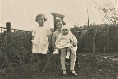
Photograph, Isabel and Beryl Mair with cousin Margaret Williamson, 1916
David Miller (Dave) Mair (1879-1938) married Lily Vipond Deakin (1890-1945) in 1910. They had 5 children: Geoffrey David (1913-1970), Beryl (1916-1976), Gwynneth (1917-1997), Isabel Lillian (1921-1997) and Shirley Inez (1928-1968). Personal communication from Laurie Newton, Beryl's daughter: Dave and Beryl initially lived in East Melbourne after they married. Geoffrey, Beryl and Gwynneth were born in East Melbourne. They subsequently moved to Louise Avenue, Mont Albert and Isabel may have been born while they were there. Later they purchased 20 Barton Street, Mont Albert. Shirley was born after they moved to Barton Street. The children attended Mont Albert Central School. Lily's sister Alice married Hector Williamson (1892-1981) in 1921. Hector was a civil servant and worked at the Melbourne Museum, where accommodation was provided. They had one daughter Margaret. Another sister Minnie (Min) married Hector's brother Charles (Charlie) Prosser Williamson (1893-1961). Charlie was an engineer and ran a hardware business in Whitehorse Road (near the tram terminus). They lived at 12 Barloa Road and had one son, Donald Williamson, born 1924. Donald (Service number VX146389) entered RMC on 28 February 1942 and graduated on 14 December 1943. He enlisted the following day as a Lieutenant with the 2/32 Infantry Battalion. He was mentioned in Despatches "for exceptional service in the field S.W.P. area". Promulgated in the Commonwealth of Australia Gazette 6 March 1947; was killed in action in Brunei on 3 July 1945. Williamson was buried in grave B.C.10 in Labuan War Cemetery, Borneo, Malaysia.This is part of a large donation related to the Deakin, Mair and Young families with connections to the Surrey Hills / Mont Albert area.A sepia coloured photo with a cream border of 2 girls in either a front or back garden. One is sitting on a cane chair and holding a young baby; the other is standing close by. The fence behind appears to be of constructed of posts with a metal horizontal support and wire mesh. REAR: In blue biro "Isabel Beryl / Margaret Williamson / (cousin) / Auntie Alice & Uncle Hec / her mother & father" The handwriting is believed to be that of Beryl Mair. margaret williamson, beryl mair, isabel mair, children -
 The 5th/6th Battalion Royal Victoria Regiment Historical Collection
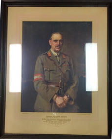
Print - Reproduction, framed, General Sir John Monash
Framed print of General Sir John Monash standing with hands held to his front in uniform against a dark background. Encased in a moulded timber frame and behind an off white backing board with fade red borders General Sir John Monash G.C.M.G, K.C.B, V.D, B.A, D.C.L, LL.D., D. Eng., M. Inst.C.E Grande Officier de l' Ordre de la Couronne and de Croix de Guerre(Belguim); Grande Officier de la Legion d'Honneur and de Croix de Guerre avec Palme ( France); Distinguished Service Medal ( USA) commanded 4th. Aust. Inf.Bde (15 Sept., '14- 9 July, '16), 3rd Aust Div (10 July, '16-31 May,'18) and Australian Army Corps (1 June-30 Nov.,'18); Director General Repatriation and Demobilisation ( 1 Dec.,'18-15 Nov., Nov.,'19). Laanding at Anzac - Sari Bair - Messines- Broodseinde - Passchendaele - Villers-Bretonneux -Hamel - Amiens - Mont St Quentin - Hargicourt - Hindenburg Line - Beaurevoir Line Chairman of the State Electricity Commission of Victoria 1921/1931 Member of Council of Defence , 1921/1931 1865-1931 sir john monash, john longstaff, 1919, ww1, first world war, great war -
 Orbost & District Historical Society
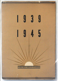
magazine, McLaren & Co Pty Ltd, 1939 1945, C1945
This book/magazine is a record of the company's tasks in WW11. It acknowledges the "debt owed to the armed forces involvement and role in defeating the enemy". The Australian operations of this company were originally founded by Hugh V. McKay in the 1890s. In 1906, H.V. McKay moved his manufacturing operations from Ballarat to Braybrook Junction (later Sunshine) on the western outskirts of Melbourne. In 1921 the company became H.V. McKay Pty Ltd. In 1930 it merged with the Australian operations of the Canadian agricultural implement and tractor manufacturer Massey Harris, to become H.V. McKay Massey Harris Pty Ltd. Throughout World War II H.V. McKay Massey Harris exported over 20,000 Sunshine drills, disc harrows and binders to England to facilitate the increase in food production. (ref Museum Victoria, Wickipedia)Inside this magazine is a photograph of a sprocket similar to that made by Orbost Motor Works during WW11. (Registration No 2001)A large stapled cardboard covered magazine with a tan coloured cover. On the front cover in dark brown print at the bottom is a rising sun with "H. V. McKay Massey Harris Pty Ltd Australia" underneath it. At the top in large font is 1939 1945. It contains coloured photographs and text. massey-harris -
 Flagstaff Hill Maritime Museum and Village
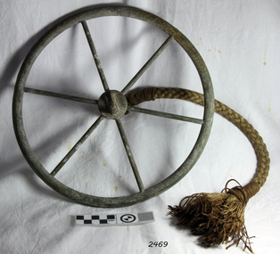
Tool - Ship Taffrail Log Flywheel, 1930+
The flywheel possibly belongs to a Walker's Cherub Mark III Ship-log taffrail, how the flywheel operates is a metal loop of the recording log would have been connected to the flywheel, so you could see if it was spinning properly. After the flywheel, is the rotor that was towed behind the ship and the revolutions of the rotor would register on the indicator, thus measuring the distance the vessel had travelled. Thomas Ferdinand Walker (1837–1921) first patented the Cherub log in 1878. It was one of the first logs in which the recorder was placed onboard a ship rather than being incorporated as part of the rotor. The Cherub Mark III series was produced from 1930 it came in two versions a thousand-mile which is quite rare and a five hundred-mile version.This ship log flywheel was invented and made by a significant marine instrument maker and innovator of machinery Thomas Walker. It demonstrates the huge leap taken to improve navigational accuracy at sea with an instrument that was in use for decades to measure the distance travelled at sea updated versions are in use today by mariners.Log Governor (or Fly-wheel) from a Ships Taffrail Log, metal wheel with 6 spokes, hub has rope attached for connecting to ships log. Boss the other side for attachment to the spinner.Noneflagstaff hill, warrnambool, shipwrecked-coast, flagstaff-hill, flagstaff-hill-maritime-museum, maritime-museum, shipwreck-coast, flagstaff-hill-maritime-village, log governor -
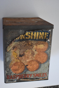 Warrnambool and District Historical Society Inc.
Biscuit Tin, Ballarat Products Limited (Sunshine Biscuit Co.), Mid 20th century
This tin came from the Sunshine Biscuit Factory in Ballarat. James Long established a confectionery business in Ballarat in 1854 and in 1921 it was known as the Sunshine Biscuit Company. In 1923 the factory was destroyed by fire and rebuilt. During World War Two 80% of the factory products went to the armed services. In 1947 the company was known as Ballarat Products Ltd and in 1962 it was called Sunshine Biscuits Ltd. In 1977 the factory was used to produce dry pet food (Friskies). The building was closed in 1991 and the site developed to include a supermarket, shops and housing. Up till about the late 1950s biscuits were mostly not packaged but sold loose by the pound in grocery stores from tins such as this. Broken biscuits were also sold at a cheaper price. Some biscuits were also sold at that time in smaller tins. This tin is of interest as an example of the tins from which biscuits were sold in the first half of the 20th century. It will be useful for display.This is a rectangular-shaped biscuit tin which is much rusted. The tin has a multi-coloured paper label that has been pasted around the sides. Much of this label has been torn away. The label shows images of biscuits. There is printing on the label and on the bottom of the tin. ‘Sunshine Raspberry Smiles’ ‘Ballarat Products Ltd.’ ‘This tin is not sold with the contents thereof but remains the property of Sunshine Biscuit Co Ballarat’ ‘Made in Australia 054’ sunshine biscuit factory, ballarat, history of warrnambool -
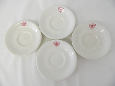 Kiewa Valley Historical Society
Saucer Ceramic, circa 1940's to 1950's
This item was used by the State Electricity Commission of Victoria in their mess rooms for their workers during the construction of the Kiewa Hydro Electricity Scheme. The imprint of the year "1921" was to identify the year that the SECV was formed and relieved the private VHEC (Victorian Hydro-Electric Company). As the scheme was of such a huge, isolated and time consuming nature the feeding of its workers was quite demanding of cutlery and crockery. The use of sturdy English cups and saucers was essential. The period of construction and the isolation of the Kiewa Valley area placed heavy demand for "solid" crockery that could wear abusive handling. This period in time was one when crockery, whether for domestic or commercial use, was imported from "mother" England. This scenario was more so for governmental bodies such as rail, jails and electricity providers than domestic users. The influx of cheaper Asian crockery had not yet begun.This type of crockery item was used by the thousands of SEC Victorian staff and construction workers involved in the building of the Kiewa Hydro Electricity Scheme, over the extensive period (1938 to 1961). This was a period when Government bodies and other semi- government organisations were still tied to the "establishments" of "mother" England. It was a period in Australia's development when the Asian influence was very weak and the established ties to England and Europe was still very strong. The majority of heavy equipment and machinery was either made in England or Europe. Local/European expertise in dam construction and water management in alpine terrain came from migrants or specially recruited English and Europe specialists. The quality of workmanship from big steel manufacturing plants in England and Europe could not be matched from anywhere else in the developed world.This item is a white ceramic State Electricity Commission Of Victoria saucer (tea /coffee). It is made in England and is of strong and durable ceramic. The bottom cup indent is for either tea or coffee cups of a similar ceramic structure. The 5mm thickness of the ceramic suggests this saucer belongs to a commercial kitchen environment and not domestic. The indent bottom of the saucer is 5mm deep with a side curvature ratio of 2:5. The ceramic is glazed to a commercial standard (worker's mess). See also KVHS 0128 (B to D)The seal of the State Electricity Commission Of Victoria is imprinted on the top inside rim within a curved scroll. Snuggled within the borders of the scroll is a banner with the five stars of the southern cross and an arm with a closed fist projecting from the top with five lightning bolts projecting outwards. On the underside "Vitrified sold by Cafe & Hotel Supplies Pty Ltd Dunn Bennett & Co. Ltd. Burslem Made in England"saucer, plate, secv, state electricity commission of victoria, crockery, mt beauty chalet, bogong mess hall -
 City of Moorabbin Historical Society (Operating the Box Cottage Museum)
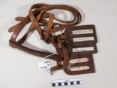
Leather, luggage straps and labels c1916, 20thC
Leather straps were commonly used to secure cases and other forms of luggage when traveling. The labels enabled easy identification when collecting luggage from transport carriages, coaches, buses and trains. 10th Field Company, Australian Engineers WW1 1914-18. The 10th Brigade was an infantry brigade of the Australian Army. Originally formed in 1912 as a Militia formation, the brigade was re-raised in 1916 as part of the expansion of the Australian Imperial Force following the end of the Gallipoli campaign. It subsequently saw service on the Western Front in France and Belgium during the First World War. After the war it was disbanded but was re-raised in 1921 as a part-time formation based in the state of Victoria. During the Second World War the brigade was used in a garrison role in Australia before being disbanded in 1942.These leather straps and labels were attached to the luggage of an Australian soldier during early 20th C who may have been a resident or relative of a resident in City of MoorabbinLeather luggage straps with metal buckles and 3 luggage address labels attached.Label 1 - L.D.McCallum Sgt / 10th Fd Coy AE Label 2 - Healesville Label 3 - Maryborough leather, straps, belts, luggage labels, tools, saddles, wallets, personal effects, horses, drays, world war 1 1914 -18, world war 2 1939-45, army, 1st aif, military, 10th field company australian engineers, western front, france, belgium, -
 St Kilda Historical Society
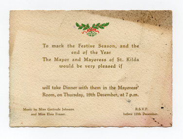
Ephemera - Invitation - mayoral dinner, To mark the Festive Season and the end of the Year, 1918 or 1929
Although the name of the Mayor and Mayoress, and the year of the invitation are not stated, the fact that music was provided by 'Miss Gertrude Emily Johnson' provides a possible clue as to the date. Gertrude Emily Johnson (1894-1973), coloratura soprano and theatre administrator, was born on 13 September 1894 at Prahran, Melbourne. She was a student of (Dame) Nellie Melba at the women's singing school that Melba founded at the Albert Street Conservatorium, East Melbourne (later the Melba Memorial Conservatorium). The date specified in the invitation, Thursday 19th December, indicates that the event was either in 1918 or 1929. As Gertrude Johnson moved to London in February 1921 and returned to Australia in 1935, when she retired from her singing career, it appears likely that the invitation to the mayoral dinner was for 19 December 1918. Elsie Fraser would have accompanied her on the piano.Cream coloured card printed in gold and with Christmas bells and holly in green and red, being an invitation for dinner with the Mayor and Mayoress of St KildaTo mark the Festive Season, and the end of the Year, the Mayor and Mayoress of St Kilda would be very pleased if ... will take Dinner with them in the Mayoress' Room, on Thursday, 19th December, at 7pm. Music by Miss Gertrude Johnson and Miss Elsie Fraser. RSVP before 12th December.gertrude johnson, elsie fraser, st kilda council, st kilda mayoral function -
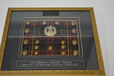 Wangaratta RSL Sub Branch
Framed buttons and badges
After the First World War the defence of the Australian mainland lay with the part-time soldiers of the Citizens Military Force (CMF), also known as the Militia. The Militia was organized to maintain the structure of the First AIF and kept the same numerical designations. The Militia units were distributed in the same areas the original AIF units were raised. Consequently, Militia units were also known by the name of their shire. Thus, the Victorian 37th Infantry Battalion was the "Hunt Regiment", while the 52nd Infantry Battalion was the "Gippsland Regiment". Both were raised in 1921 and linked in 1930, forming the 37th/52nd Infantry Battalion. In 1937 the battalion was separated but merged again in August 1942, after Japan's entry into the Second World War and the subsequent reorganisation of the Australian Army. carved gold coloured metal frame with green mount containing 3 silver and 2 green badges 8 large and 7 small gold coloured buttons on tartan cloth background.37th-52rd Australian Infantry Battalion Affilitated with The Queens "Own" Cameron Highlanders 37th/52nd australian infantry battalion, cameron highlanders -
 Bendigo Historical Society Inc.
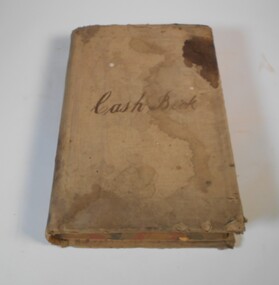
Financial record - Kelly and Allsop collection: cash book
1. Michael Peter Kelly (1853-1929) was born in Galway, Ireland and came to Australia in 1870. He was a director of many mines and was elected to the Bendigo Stock Exchange in 1882. At one point he was the chairman of the Exchange. He married Margaret Jane Carr in 1887 and they lived at "Norwood", Wills St., Bendigo. 2. Arthur Allsop (1856 - 1921) was a renowned athlete in many fields, including running, lacrosse, cricket, football and lawn bowls. He was an independent bookmaker and was elected to the Bendigo Stock Exchange in 1906. He was also a Past Grand Master of the MUIOOF lodge. After his time in Bendigo, and following the death of his wife in 1914, he moved to Melbourne and then Sydney where he died. For full biography see Item 6896.5Very large cash book for Kelly and Allsop stockbrokers. The book has 386 double pages, recording the daily cash movements. The book covers the period from September 1897 to December 1906. All pages are filled.Cash book on the front coverkelly and allsop, cash book, stockbrokers -
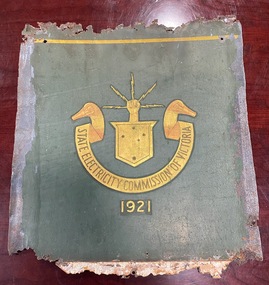 Ballarat Tramway Museum
Functional object - Tramcar component - Panel ex Geelong tramcar No. 2 with SECV logo
The penel was recovered by the restorer of MESCo/SECV Geelong tram No. 2 and provided information about the paint scheme and layout. The Geelong tramway system closed in March 1956, No. 2 making its last run in January 1956. The body was subsequently sold to Phil Shoppee, a farmer at Murradoc on the Bellarine Peninsula. The farmer had used the tram body as a feed store, with this part placed up against a water tank or similar. This prevented it from being painted over. The panel shows the methodology of securing it to the tram body and the location of the lining and the emblem. The SECV logo or emblem dates from the formation of the SECV in 1921. The panel dates from the 1950s, possibly from a repaint after the side entry gates on the car were replaced by hinged doors in the mid-1950s. See reference.Yields information about the location of the lining and logo on the tram body and colours. One of the few original SECV logos formed from gold leaf in the Museum's collection.Sheet steel - treated - SEC green paint with a gold leaf SECV logo or emblemtrams, tramways, geelong, tram 2, secv tramways, logos, secv, emblems -
 Kew Historical Society Inc
Photograph - Yarra Valley Floods: Kew East, 1916
Flooding of the Yarra Valley, including that section of the Yarra bordering Kew and Kew East in the north and west of the municipality, was a regular occurrence. Extreme flood events of the Yarra River are recorded to have occurred in 1891, 1901, 1916, 1923 and 1934. The Municipality of Kew's response to these floods was to enact planning decisions restricting residential development in flood prone areas following the floods of 1916, 1921 and 1934. While floods continued after the development of the Upper Yarra Reservoir (construction 1948-57), the regularity and extent of these inundations diminished. During the nineteenth century, the land abutting the south side of the Yarra in Kew was devoted to dairy farming. In the twentieth century, before and after the construction of the Eastern Freeway, much of this low-lying area was used as golf courses and public parks.One of a collection of photographs of flooding in the Kew section of the Yarra Valley which are in important research resource for the location and extent of flooding in the first half of the twentieth century. Flooding of the Yarra Valley at East Kew in 1916. The view is taken from the intersection of Kilby Road with what is believed to be Birdwood Street, looking across the flood waters to Ivanhoe. The extensive flooded area shown in the photograph would have included the Kew Golf Club. Verso: "Floods along Kilby Road / near Birdwood St? & Kilby Road / 1917? / 87yarra river, yarra valley, floods -- kew, kilby road -- kew (vic.), kew golf club -
 Kew Historical Society Inc
Photograph - Yarra Valley Floods: Kew East, 1916
Flooding of the Yarra Valley, including that section of the Yarra bordering Kew and Kew East in the north and west of the municipality, was a regular occurrence. Extreme flood events of the Yarra River are recorded to have occurred in 1891, 1901, 1916, 1923 and 1934. The Municipality of Kew's response to these floods was to enact planning decisions restricting residential development in flood prone areas following the floods of 1916, 1921 and 1934. While floods continued after the development of the Upper Yarra Reservoir (construction 1948-57), the regularity and extent of these inundations diminished. During the nineteenth century, the land abutting the south side of the Yarra in Kew was devoted to dairy farming. In the twentieth century, before and after the construction of the Eastern Freeway, much of this low-lying area was used as golf courses and public parks.One of a collection of photographs of flooding in the Kew section of the Yarra Valley which are in important research resource for the location and extent of flooding in the first half of the twentieth century. Flooding of the Yarra Valley at East Kew in 1916. The view is taken from a street (maybe Birdwood Avenue) intersecting with Kilby Road looking northeast across the flood waters to Ivanhoe and Heidelberg. The extensive flooded area shown in the photograph would have included remnant dairy farms and the Kew Golf Club. Verso: "Floods / Yarra River / East Kew / Kilby Road / 1917? / 87"yarra river, yarra valley, floods -- kew, kilby road -- kew (vic.), kew golf club -
 Kew Historical Society Inc
Photograph - Flooding of the Yarra Valley at Kew East, 1974
Flooding of the Yarra Valley, including that section of the Yarra bordering Kew and Kew East in the north and west of the municipality, was a regular occurrence. Extreme flood events of the Yarra River are recorded to have occurred in 1891, 1901, 1916, 1923 and 1934. The Municipality of Kew's response to these floods was to enact planning decisions restricting residential development in flood prone areas following the floods of 1916, 1921 and 1934. While floods continued after the development of the Upper Yarra Reservoir (construction 1948-57), the regularity and extent of these inundations diminished. During the nineteenth century, the land abutting the south side of the Yarra in Kew was devoted to dairy farming. In the twentieth century, before and after the construction of the Eastern Freeway, much of this low-lying area was used as golf courses and public parks.Late example of the capacity of the Yarra Valley at Kew to flood, even though drainage works and the Upper Yarra Reservoir had reduced their regularity.Original black and white print photograph of the low-lying land at East Kew under floodwater on 16 May 1974. The vantage point of the photographer is Lister Street. In the photo, the fences of the Kilby Farm can be seen. Flooding was caused by overflowing water in Glass' Creek and the River Yarra. Annotation verso: "Hay's Paddock op No.30 Lister Street / 16 May 1974 11.50am / R.L. 46.04"hays paddock, floods, yarra river, glass' creek, lister street -
 Kew Historical Society Inc
Photograph - Flooding of the Yarra Valley at Kew East, 1974
Flooding of the Yarra Valley, including that section of the Yarra bordering Kew and Kew East in the north and west of the municipality, was a regular occurrence. Extreme flood events of the Yarra River are recorded to have occurred in 1891, 1901, 1916, 1923 and 1934. The Municipality of Kew's response to these floods was to enact planning decisions restricting residential development in flood prone areas following the floods of 1916, 1921 and 1934. While floods continued after the development of the Upper Yarra Reservoir (construction 1948-57), the regularity and extent of these inundations diminished. During the nineteenth century, the land abutting the south side of the Yarra in Kew was devoted to dairy farming. In the twentieth century, before and after the construction of the Eastern Freeway, much of this low-lying area was used as golf courses and public parks.Late example of the capacity of the Yarra Valley at Kew to flood, even though drainage works and the Upper Yarra Reservoir had reduced their regularity.Original black and white print photograph of the low-lying land at East Kew under floodwater on 16 May 1974. The vantage point of the photographer is Lister Street. Flooding was caused by overflowing water in Glass' Creek and the River Yarra. Annotation verso: "Lister Street looking north / Flood level / 16 May 1974 11.30am / R.L. 46.04"hays paddock, floods, yarra river, glass' creek, lister street -
 Kew Historical Society Inc
Photograph - Flooding of the Yarra Valley at Kew East, 1974
Flooding of the Yarra Valley, including that section of the Yarra bordering Kew and Kew East in the north and west of the municipality, was a regular occurrence. Extreme flood events of the Yarra River are recorded to have occurred in 1891, 1901, 1916, 1923 and 1934. The Municipality of Kew's response to these floods was to enact planning decisions restricting residential development in flood prone areas following the floods of 1916, 1921 and 1934. While floods continued after the development of the Upper Yarra Reservoir (construction 1948-57), the regularity and extent of these inundations diminished. During the nineteenth century, the land abutting the south side of the Yarra in Kew was devoted to dairy farming. In the twentieth century, before and after the construction of the Eastern Freeway, much of this low-lying area was used as golf courses and public parks.Late example of the capacity of the Yarra Valley at Kew to flood, even though drainage works and the Upper Yarra Reservoir had reduced their regularity.Original black and white print photograph of Hay's Paddock under floodwater on 16 May 1974. The vantage point of the photographer is Keystone Crescent looking east. Flooding was caused by overflowing water in Glass' Creek and the River Yarra. Annotation verso: "Keystone Cr looking east / 16 May 1974 11.50am"hays paddock, floods, yarra river, glass' creek -
 Kew Historical Society Inc
Photograph - Flooding of the Yarra Valley at Kew East, 1974
Flooding of the Yarra Valley, including that section of the Yarra bordering Kew and Kew East in the north and west of the municipality, was a regular occurrence. Extreme flood events of the Yarra River are recorded to have occurred in 1891, 1901, 1916, 1923 and 1934. The Municipality of Kew's response to these floods was to enact planning decisions restricting residential development in flood prone areas following the floods of 1916, 1921 and 1934. While floods continued after the development of the Upper Yarra Reservoir (construction 1948-57), the regularity and extent of these inundations diminished. During the nineteenth century, the land abutting the south side of the Yarra in Kew was devoted to dairy farming. In the twentieth century, before and after the construction of the Eastern Freeway, much of this low-lying area was used as golf courses and public parks.Late example of the capacity of the Yarra Valley at Kew to flood, even though drainage works and the Upper Yarra Reservoir had reduced their regularity.Original black and white print photograph of the low-lying land at East Kew under floodwater on 16 May 1974. The vantage point of the photographer is Lister Street. Flooding was caused by overflowing water in Glass' Creek and the River Yarra. Annotation verso: "Lister St looking same as No.3 / 16 May 1974 11.30"floods, yarra river, glass' creek, lister street -
 Kew Historical Society Inc
Photograph - Flooding of the Yarra Valley at Kew East, 1974
Flooding of the Yarra Valley, including that section of the Yarra bordering Kew and Kew East in the north and west of the municipality, was a regular occurrence. Extreme flood events of the Yarra River are recorded to have occurred in 1891, 1901, 1916, 1923 and 1934. The Municipality of Kew's response to these floods was to enact planning decisions restricting residential development in flood prone areas following the floods of 1916, 1921 and 1934. While floods continued after the development of the Upper Yarra Reservoir (construction 1948-57), the regularity and extent of these inundations diminished. During the nineteenth century, the land abutting the south side of the Yarra in Kew was devoted to dairy farming. In the twentieth century, before and after the construction of the Eastern Freeway, much of this low-lying area was used as golf courses and public parks.Late example of the capacity of the Yarra Valley at Kew to flood, even though drainage works and the Upper Yarra Reservoir had reduced their regularity.Original black and white print photograph of the low-lying land at East Kew under floodwater on 16 May 1974. The vantage point of the photographer is at Willsmere Road. The road itself is underwater.Annotation verso: "Willsmere Rd / Same as No.7 / 16 May 1974 11.15am"floods, yarra river, willsmere road -
 Kew Historical Society Inc
Photograph - Flooding of the Yarra Valley at Kew East, 1974
Flooding of the Yarra Valley, including that section of the Yarra bordering Kew and Kew East in the north and west of the municipality, was a regular occurrence. Extreme flood events of the Yarra River are recorded to have occurred in 1891, 1901, 1916, 1923 and 1934. The Municipality of Kew's response to these floods was to enact planning decisions restricting residential development in flood prone areas following the floods of 1916, 1921 and 1934. While floods continued after the development of the Upper Yarra Reservoir (construction 1948-57), the regularity and extent of these inundations diminished. During the nineteenth century, the land abutting the south side of the Yarra in Kew was devoted to dairy farming. In the twentieth century, before and after the construction of the Eastern Freeway, much of this low-lying area was used as golf courses and public parks.Late example of the capacity of the Yarra Valley at Kew to flood, even though drainage works and the Upper Yarra Reservoir had reduced their regularity.Original black and white print photograph of the low-lying land at East Kew under floodwater on 16 May 1974. The photograph is of Hyde Park looking north-east.Annotation verso: "Hyde Park looking nth-east / Flood Level / 16 May 1974 11.15am / R.L. 46.61"floods, yarra river, hyde park -
 Kew Historical Society Inc
Photograph - Flooding of the Yarra Valley at Kew, 1974
Flooding of the Yarra Valley, including that section of the Yarra bordering Kew and Kew East in the north and west of the municipality, was a regular occurrence. Extreme flood events of the Yarra River are recorded to have occurred in 1891, 1901, 1916, 1923 and 1934. The Municipality of Kew's response to these floods was to enact planning decisions restricting residential development in flood prone areas following the floods of 1916, 1921 and 1934. While floods continued after the development of the Upper Yarra Reservoir (construction 1948-57), the regularity and extent of these inundations diminished. During the nineteenth century, the land abutting the south side of the Yarra in Kew was devoted to dairy farming. In the twentieth century, before and after the construction of the Eastern Freeway, much of this low-lying area was used as golf courses and public parks.Late example of the capacity of the Yarra Valley at Kew to flood, even though drainage works and the Upper Yarra Reservoir had reduced their regularity.Original black and white print photograph of the low-lying land at East Kew under floodwater on 16 May 1974. The photograph is taken from 43 Kellett Grove.Annotation verso: "Kellett Gve No.43 / Flood Level / 16 May 1974 11.40am"floods, yarra river, kellett grove -
 Surrey Hills Historical Society Collection
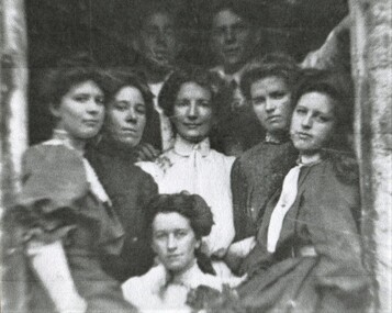
Photograph, Deakin family, c1905, 1905
Thomas Henry Deakin (1845-1915), born in Monmouthshire, Wales and his wife Janet (Jessie) Longmore (1851-1939), born in Morayshire, Scotland had 2 sons: John Henry (1879-1962) and William Andrew (1883-1939) and 4 surviving daughters. A fifth daughter Daisy Jessie was born in 1880 and died the same year at the age of 7 months. Elsie Longmore Deakin (1881-1969) was a nurse and remained single; Minnie Winifred (1886-1966) married Charles Williamson in 1923; Lily Vipond (1890-1943) married David Mair in 1910 and Jessie Alice, known as Alice, married Hector Williamson in 1921. Hector and Charles were brothers. Dave Mair was a very keen sportsman. This is part of a large donation of material from the Deakin, Mair and Young families. The Deakin, Mair and Young families had many connections with Mont Albert and Surrey Hills.A black & white photocopy of 6 young women and 2 young men who are casually grouped standing in what appears to be a doorway.On rear in grey lead pencil: "Deakin family 1905? / Front left Minnie / Centre Lily Vipond / Right Alicedeakin family, lily vipond deakin, minnie winifred deakin, minnie deakin, lily deakin,jessie alice deakin, alice deakin -
 Mentone Grammar School
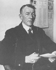
J Allan Anderson - one of the founders of Mentone Grammar School
J Allan Anderson graduated from the University of Melbourne in 1902. The following year he joined a law practice in the Victorian country centre of Stawell, where he met and married Ethel M. Allingham. Moving to East Kew, Melbourne, in 1917, where his son attended Trinity Grammar School. By March 1921 the family had exchanged their annual summer holidays at Mentone for permanent residence when they moved into Captain Dawson's former home, 'Riviera' off Mentone Parade. Disappointed with standards at this son's new local school and now living in a fast-growing town and district, in 1922, on a train journey to his office in the City, 46-year-old solicitor J.A. Anderson came up with the idea to form a new grammar school for boys in Mentone.