Showing 2474 items matching " township"
-
 Bendigo Historical Society Inc.
Booklet - Out & About around Bendigo
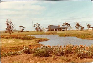
BHS CollectionBooklet of 95 pages. Red and yellow front covers with colour and B&W photos. Brief descriptions of townships around and north of Bendigo illustrated with B&W photos plus a map on page 5. Insert of sketch map of Kamarooka Forest and bird guide to forest. Edited by Jean and Ken Arnold. Published by Crown Castleton Publishers, Bendigo and printed by Centre State Printing, Maryborough, Victoria. 'M & J Qualtrough' sticker on title pagebendigo, townships -
 Daylesford & District Historical Society
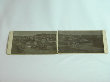
Photograph Daylesford Panorama, J. J. Crawford, Western Avenue to Wombat Hill woman and two girls c1900, Circa 1900
Early panorama of Daylesford circa 1900 with views of Wombat Hill from Western Avenue. Taken by J. J. Crawford of Mitiamo late resident of Daylesford.A unique early view of Daylesford showing large areas of vacant land pre modern development.2 B&W photos forming panorama of Daylesford township, looking South East to Wombat Hill & beyond with many buildings clearly visible. 3 women/girls in foreground. Circa 1900. Mounted on 2 pieces of cardboard, stuck together by sewing red fabrick onto mounting boards. Taken at western Avenue by J. J. Crawford of Mitiamo Victoria photographic studio a late resident of Daylesford. J.J. Crawford Mitiamo (Stamp) Donated to Daylesford & District Historical Society by (J.J. Crawford Mitiamo) (late of Daylesford) D13wombat hill, town views, clothing -
 Glenelg Shire Council Cultural Collection
Mixed media - Framed Art Work, Wallace, Carmel et al, Lagoon Page 3, 2004
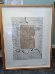
© Anna Lanyon , Carmel Wallace 2004. Apart from any fair dealing for the purposes of private study, research, criticism or review permitted under the Copyright Act, no text, image or part thereof may be reproduced, stored in a retrieval system, or transmitted in any form, without prior written permission from the authors.This suite of etchings explores the natural and social history of Fawthrop Lagoon, an ancient intertidal lagoon that lies at the heart of Portland on the far south-west coast of Victoria, Australia. The work records and interprets essential moments in the life of the lagoon, the plants, birds, insects, water-creatures and humans who have lived and continue to live around its shores. White card backing with white torn looking inner frame. Centre is print of an extract taken from a survey record of the Fawthrop Lagoon Portland listing the name of the reserve, Allotment number, section number, Township, and Municipality. Markings and dates have been written in. Around the outside of the centre image is hand written wording in fine black ink and a map of the town of Portland also in black ink.4/30 Lagoon, Page 3 Carmel Wallacefawthrop lagoon, portland, victoria, australia, plants, birds, insects, water, creatures, humans -
 Orbost & District Historical Society
black and white photograph, c1920-1954
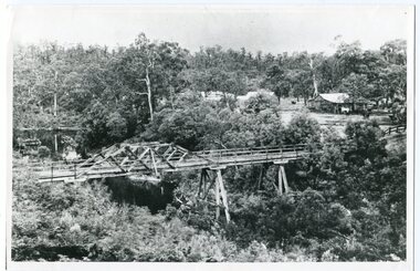
This is a copy of "THE BRIDGE AT BOGGY CREEK, NOWA NOWA, LAKE TYERS." which is a Rose Stereograph Co postcard. Boggy Creek Bridge was built in 1916 as part of the Bairnsdale to Orbost extension to the main Gippsland Railway, and is situated in the middle of the township of Nowa Nowa, crossing a steep-sided and well-timbered creek-valley. This section of the line closed in 1987. This bridge plays a major part in the identity and history of the town of Nowa Nowa, This item is associated with the East Gippsland Railway.A large black / white photograph of a large wooden bridge across a creek. There is a house and outbuildings in the background on the right. It is in a bush setting. on back - "Boggy Creek bridge - Nowa Nowa 1887 LaTrobe Collection"boggy-creek-bridge east-gippsland-railway -
 Warrnambool and District Historical Society Inc.
Book, Boy's own sea stories, Early 20th century
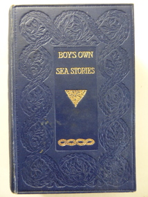
This book of sea stories belonged to C. Simpson of ‘Elm Bank’, Wangoom. Charles Simpson was a farmer at Wangoom in the 1860s. The township of Wangoom is about ten kilometres from Warrnambool. Charles Simpson was the brother of George Simpson of Nullawarre and William Simpson who had a drapery store in Warrnambool. The owner of the book would be a descendant of one of these early settlers. This book is of interest as it belonged to a member of the Simpson families, several of whom were early settlers in the Warrnambool district. This is a hard cover book of 424 pages. The cover is dark blue with gold lettering and gold scroll work. The book has a preface, 42 chapters of sea stories and, at the back of the book, several pages of advertisements for other books published by Ward, Lock and Co. There are many black and white sketches scattered throughout the text. The inscriptions are handwritten in black ink. ‘C. Simpson, Elm Bank, Wangoom’ (3 entries) simpson families of 19th century, warrnambool and district -
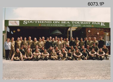 Bendigo Military Museum
Photograph - Group Photos of Lithographic Squadron, Army Survey Regiment, c1990s
These three photographs of Lithographic Squadron were taken in the 1990s. Photos .2P and .3P were taken at the Army Survey Regiment, Fortuna, Bendigo. .1P was taken as the background sign indicates, at the Southend on Sea Tourist Park, close to the township of Millicent in South Australia. Lithographic Squadron was in this location probably as part of Regimental or Adventurous Training in 1992.This is a set of photographs of Lithographic Squadron, Army Survey Regiment, Bendigo c1990s. The photographs were printed on photographic paper and are part of the Army Survey Regiment’s Collection. The photographs were scanned at 300 dpi. .1) - Photo, colour, 1992, Lithographic Squadron .2) - Photo, colour, 1991, Lithographic Squadron .3) - Photo, colour, Sep 1993, Lithographic Squadron.1P and .2P - annotated on back with date .3P – annotated on front with dateroyal australian survey corps, rasvy, army survey regiment, army svy regt, fortuna, asr, litho -
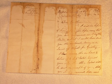 Mortlake and District Historical Society
Letter for payment of account Mortlake Mill, March 7 1864
This letter was sent by a customer D. Menzies at Skipton to the Mortlake Mill, detailing an unusual payment method for the processing of his wheat into flour. David Menzies was a Scots farmer who lived in Skipton c. 1860's on a bend in the Mount Emu Creek. He helped establish the local school and a lane in the township bears his name. The letter illustrates the nature of commerce and the difficulties of communication and life generally in the country at the time. The bluestone Mortlake Mill built in 1856, has been a prominent landmark in Mortlake for over 150 years. It played a significant role in the commercial life of the town and was initially a wind-mill to process district grain for sale. The goldrush at Ararat 100 km. away led to a temporarily increased population and demand for foodstuffs. In 1857 the Mill was sold to Aikman, Hamilton and Geddes who converted it to steampower and later built the prominent chimney, which is on the Heritage Register as part of the National Estate. D. Menzies at Skipton lived at least 85 km away - his wheat which urgently needed milling, faced a slow and arduous journey by bullock dray. After the demise of the Ararat goldfields and the decline in population (as well as the district soils proving unsuitable for sustained wheat cultivation), the operation of the Mill declined too and the proprietors increased their involvement in other activities - supply of building materials, timber felling and sawmills. Despite the apparent difficulties of conducting business in the 1850's, it is notable that commerce thrived at that time in country districts, as an examination of Mill accounts and records show.Handwritten letter dated 1864 (water-stained)Skipton March 7 1864 [to] Messrs. Hamilton & Co. Mortlake. Dear Gentlemen, I was in hope of hearing from you before now that you had commenced working the Mill, & that I could have sent you the enclosed money [for a] load of wheat for Gristing. Please receive the enclosed 2 halves of 2 [two] 5 [pound sign] notes forwarded to your account. the other halves will be sent on receipt of your stating you having received those notes sent. As I am out of flour be so good as say how soon I may send a load of wheat. In haste I am Gentlemen Yours truly D. Menziesmortlake mill grain wheat hamilton geddes aikman laang dixie menzies skipton -
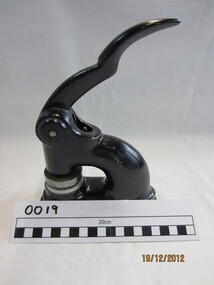
Donald History and Natural History Group operating the Donald Court House Museum
Weighing Scales
These scales were used by Georgie Ah Ling, who operated a market garden on the edge of the township of Donald for over 70 years. The scales were located in a shed next to his hut located along the Jeffcott Road opposite the Donald Racecourse. He used these scales to weigh produce before delivering it around the town by horse and cart. Black spray painted weighing scales body, 5 weights of different sizes and repainted silver plate. One 4 lbs, two 1 lbs, one 8 oz., and one 4 oz. weightScales marked “TO WEIGH 28 lb”. 4 lbs weight marked “J & J Whitehouse.TIPTON. 4 lbs”. 1 lb. weight marked “W & T AVERY.LTD.BRIM 1 lbs”scales, georgie ah ling, market garden, donald, hut, -
 Wannon Water
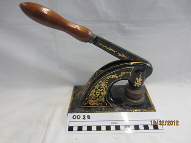
Cast iron seal embossing press, Excello, Seal
Heywood Waterworks Trust was constituted on 20 November 1962 upon application by Councillors of the Shire of Portland to construct, manage and maintain the works for the supply of water to the township of Heywood. The Trust was abolished on 1 July 1984 under the Water and Sewerage (Restructuring) Act 1983 when it amalgamated with the Heywood Sewerage Authority to form Heywood Water BoardA cast iron seal press, . This was used by Heywood Waterworks Trust to emboss agreements and official documents. Die is still attached to the press. It reads: Heywood Waterworks Trust 1963Small metal machine painted black and mounted onto a black rubber base. Two dies are attached with the seal of Heywood Waterworks Trust. Paper is placed between the dies, the handle depressed and the seal embossed on the paper under pressure as a blind (inkless) embossing. The seal consists of two circles with the wording "Heywood Waterworks Trust".Heywood Waterworks Trust 1963/ Excello / Reg Trade Mark/ Seal Press/ Pat NO 420419/Size No 2/Inscription on rubber base: "EXCELLO SEAL PRESS" / REGD TRADE MARK / 1. PATENT ROLLER BEARING HANDLE PAT. NO. 420419 / 2. DURABLE PLASTIC COUNTER / 3. RUBBER DESK PROTECTOR / STANDARD RUBBER TYPE CO. LTD. / TOKYO JAPAN"heywood, public administration, water supply, amalgamations -
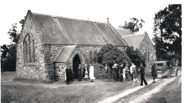 Hume City Civic Collection
Photograph, c1930s
St Mary's Anglican Church was originally built on land in Oaklands Road. It was licensed in 1859 by Bishop Perry, the first Anglican bishop of Melbourne. In the late 1960s the church was dismantled and rebuilt on its present site at Bulla, adjacent to the former Council Chambers. it was shifted to the township of Bulla because the building was under the direct path of a proposed future flightpath.vintage cars, churches, st. mary's anglican church - bulla, george evans collection -
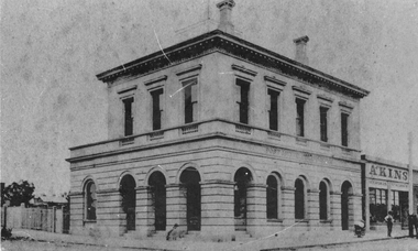 Stawell Historical Society Inc
Photograph, Stawell Post Office Cnr Wimmera and Main Streets 1875
Stawell Post office built in March 1875 replacing the 1860 weather board building in the early Township of Stawell. The stucco exterior was described as modern Italian, and the building had excellent proportions. Special reference was made to the use of slate from Great Western. The foundations are of solid granite. The difference in this photograph to 85.01 would be approximately 100 years. Stawell Post Office possibly before 1880's on Corner of Wimmera and Main Street. Man on right of photograph standing in front of Akins Seed and Stationers Store near telegraph pole and horse. stawell -
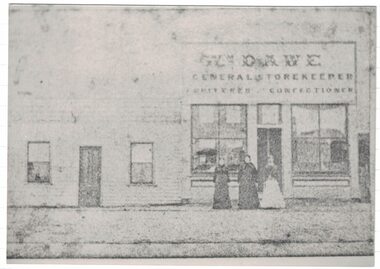 Linton and District Historical Society Inc
Photograph, Dawe's Store
The Dawe family shop is thought to have been in Sussex Street/Skipton Road, opposite Wishart's forge. W. Dawe is shown on the Township of Linton plan as the owner of Allotment 4, Section 1A. Municipal directories show "William Dawe, Fruiterer" in the 1880s, and from the 1890s "Thomas Dawe, Fruiterer". (Thomas was William Dawe's son.)A black and white copy of an original faded Photostat which shows three women standing in front of a building "Wm. Dawe General Storekeeper Fruiterer Confectioner".william dawe, shops, general store, sussex street, robert s. nelson (jnr) -
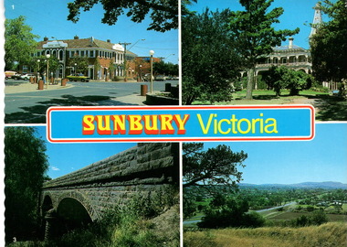 Sunbury Family History and Heritage Society Inc.
Postcard, Newcolourvue Productions Pty.Ltd, Sunbury Victoria, c1970s
The four photographs on the post card are well-known places in the town. They are the 1930s Royal Hotel building which was build on the same site of the original building on the corner of Evans and Brook Streets, Rupertswood Mansion, built 1874-45, the historic bluestone road bridge over Jacksons Creek and a view of the township in the 1970s taken from Francis Boulevard.The four views of Sunbury give an overview of the township in the 1970s before the increased development took place from the 1980s onwards.A coloured collection of four non-digital photographs of places in Sunbury in post card format. The edges of the post card are rippled. the back of the card gives details of the places as well as the maker.Sunbury Victoriaroyal hotel, rupertswood mansion, bluestone road bridge, sunbury, post cards -
![The Old Crossing-Place at Fernshawe / [by] Nicholas Caire, circa 1876](/media/collectors/550653872162f11fb04854aa/items/577b49a5d0cdd10948c74db4/item-media/577b4a0bd0cdd10948c78ebb/item-fit-380x285.jpg) Kew Historical Society Inc
Kew Historical Society IncPhotograph, Anglo-Australasian Photographic Company, The Old Crossing-Place at Fernshawe, c. 1876
Nicholas Caire was born on Guernsey in the Channel Islands in 1837. He arrived in Adelaide with his parents in about 1860. In 1867, following photographic journeys in Gippsland, he opened a studio in Adelaide. From 1870 to 1876 he lived and worked in Talbot in Central Victoria. In 1876 he purchased T. F. Chuck's studios in the Royal Arcade Melbourne. In 1885, following the introduction of dry plate photography, he began a series of landscape series, which were commercially successful. As a photographer, he travelled extensively through Victoria, photographing places few of his contemporaries had previously seen. He died in 1918. Reference: Jack Cato, 'Caire, Nicholas John (1837–1918)', Australian Dictionary of Biography.An original, rare photograph from the series 'Views of Victoria: General Series' by the photographer, Nicholas Caire (1837-1918). The series of 60 photographs that comprise the series was issued c. 1876 and reinforced a neo-Romantic view of the Australian landscape to which a growing nationalist movement would respond. Nicholas Caire was active as a photographer in Australia from 1858 until his death in 1918. His vision of the Australian bush and pioneer life had a counterpart in the works of Henry Lawson and other nationalist poets, authors and painters.Albumen silver photograph mounted on boardInscription on reverse: ‘In the distance among the foliage can be seen the New Bridge across the River Watt. Previous to its erection, the only means of crossing over to the township was across the fallen trees, which are of prodigious dimensions. The River, as may be seen, is very rapid, and, though shallow, it contains a great quantity of fish of a somewhat moderate size.’nicholas caire (1837-1918), landscape photography -
 Warrnambool and District Historical Society Inc.
Audio - Audio tapes, Shire Centenary meeting 1963, Circa 1963
The Warrnambool Shire commenced in 1863 and was 613 square miles in area and had a population of about 8000. It was divided into three ridings each with three councillors. Its industries were dairying, general farming, cheese and butter making, wool growing, sheep and cattle raising. There are more than 20 parishes and more than 29 small townships in the area The industries, agriculture, and people of the Warrnambool Shire provided substantial support to the city of Warrnambool over a long period of time. Three audio reel to reel tapes two in green and white boxesShire Centenary meeting 1963 tape1, 2, 3. depth. Two tapes stored in grey and white cardboard box, Irish recording tape, a product of AMPEXwarrnambool, warrnambool shire council, warrnambool shire centenary -
 Greensborough Historical Society
Postcards (framed), Greensborough Historical Society, Greensborough Historical Society Postcards. Series Two, 01/10/2012
Set of 6 postcards produced for sale by Greensborough Historical Society. Postcards Frame 1, top to bottom: Fallen Soldier's Memorial, Main Street 1923; Greensborough Park Tea Rooms 1920s;Greensborough Railway Station 1920s. Frame 2, top to bottom: Stubley Motors 1930s; Greensborough Township early 1900s; Main Street Greensborough 1956.6 black and white postcards in 2 black timber frames, under glass.greensborough historical society, main street greensborough, greensborough station, stubley motors -
 Victorian Interpretive Projects Inc.
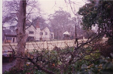
Photograph - Colour, Clare Gervasoni, Wanda Inn, Hepburn Springs, c1995, c1995
Wanda Inn was a highly regarded tea room during the 1920s and 1930s, when many people traveled to Hepburn Springs for their Honeymoon. It was destroyed by fire, along with Bellinzona Guest House, in November 2003. It was the second time Bellinzona had been destroyed by fire, the first time was in 1906 when a fire wiped out most of the township of Hepburn Springs.A colour digital image showing a picket fence, and a house in the background. The house is taken from Seventh Street and shows 'Wanda Inn' from 'Actea', (Church Avenue, Hepburn Springs) during a light snow fall. Wanda Inn was destroyed by fire in November 2003.hepburn springs, wanda inn, guest house, tea room. -
Tatura Irrigation & Wartime Camps Museum
Booklet, Dhurringile Mansion
Tells of James Winter building Dhurringile mansion, and life as it was in the surrounding townships. The mansion was completed in 1877. The name "Dhurringile"was taken from an Aboriginal word meaning "crouching emu". History of the mansion - including a home for German internees (Aug. 1941 - July 1945) a training farm for British orphans ( 1947 - 1965) and is now a minimum security prison (1965 -)17 pages of photocopy material, with B/W photos, printed on A4 paper. Held together by a stapler. Painting of the original mansion on front page.dhurringile, toolamba, james winter -
 Hume City Civic Collection
Photograph, c 1978
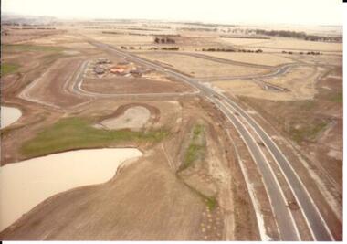
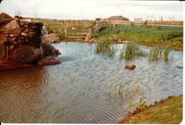
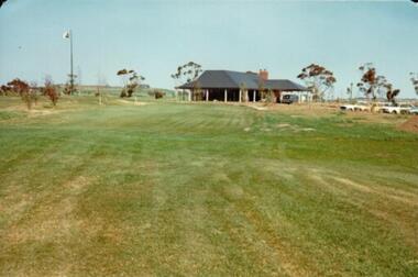
On 4th August 1978 the construction of the Goonawarra Estate commenced. The estate was formerly known as the Goonawarra Farm and overlooked the Sunbury Township and the Jacksons Creek Valley. Plans for the development included a golf course, houses and community and recreational facilities. The golf course opened in 1980 and the housing construction continued throughout the last two decades of the twentieth century and into the twenty first century.A coloured aerial photograph of a display village area under construction. Two lakes are on the LHS of the photograph and Francis Boulevard is in the foreground and the middle distance.goonawarra golf club, goonawarra farm, goonawarra housing estate, housing developments, sharkey, robert b., kilkenny homes, australian ideas homes pty.ltd., glamor homes, craftsmen homes., villa bella homes, george evans collection -
 Hume City Civic Collection
Photograph, c 1978
On 4th August 1978 the construction of the Goonawarra Estate commenced. The estate was formerly known as the Goonawarra Farm and overlooked the Sunbury Township and the Jacksons Creek Valley. Plans for the development included a golf course, houses and community and recreational facilities. The golf course opened in 1980 and the housing construction continued throughout the last two decades of the twentieth century and into the twenty first century.A coloured photograph of the reflecting pool at the entrance of the Goonawarra Golf Club. The surrounding area has been landscaped and a display home is in the distance.goonawarra golf club, goonawarra farm, goonawarra housing estate, housing developments, sharkey, robert b., kilkenny homes, australian ideas homes pty.ltd., glamor homes, craftsmen homes., villa bella homes, george evans collection -
 Hume City Civic Collection
Photograph, c 1978
On 4th August 1978 the construction of the Goonawarra Estate commenced. The estate was formerly known as the Goonawarra Farm and overlooked the Sunbury Township and the Jacksons Creek Valley. Plans for the development included a golf course, houses and community and recreational facilities. The golf course opened in 1980 and the housing construction continued throughout the last two decades of the twentieth century and into the twenty first century.A coloured photograph of the clubhouse at the Goonawarra Golf Course taken from the 10th fairway. Parked cars are visible on the RHS of the photograpg and there is a row of gum trees behind the clubhouse.goonawarra golf club, goonawarra farm, goonawarra housing estate, housing developments, sharkey, robert b., kilkenny homes, australian ideas homes pty.ltd., glamor homes, craftsmen homes., villa bella homes, george evans collection -
 Hume City Civic Collection
Photograph, c 1978
On 4th August 1978 the construction of the Goonawarra Estate commenced. The estate was formerly known as the Goonawarra Farm and overlooked the Sunbury Township and the Jacksons Creek Valley. Plans for the development included a golf course, houses and community and recreational facilities. The golf course opened in 1980 and the housing construction continued throughout the last two decades of the twentieth century and into the twenty first century.A coloured photograph of the clubhouse at Goonawarra Golf Course as seen from the 10th green. A small white van is parked ouitside the building. There is a line of trees behind the clubhouse.goonawarra golf club, goonawarra farm, goonawarra housing estate, housing developments, sharkey, robert b., kilkenny homes, australian ideas homes pty.ltd., glamor homes, craftsmen homes., villa bella homes, george evans collection -
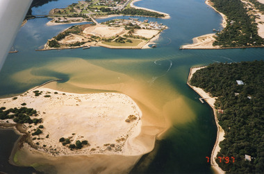 Lakes Entrance Historical Society
Photograph - Lakes Entrance, 1997
Date made 7 July 1997Colour photograph being an aerial view of the western end of Cunninghame Arm, showing the entrance between the hummocks, Bullock Island, entrance to North Arm, Snake Island surrounded by sand build-up. Lakes Entrance Victoriatopography, waterways, aerial photograph, boats and boating, township, islands -
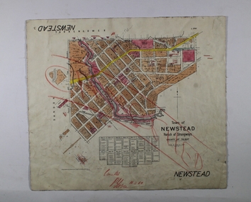 Bendigo Historical Society Inc.
Map - NEWSTEAD, 1/11/1939
Map: Town of Newstead, Parish of Strangways, County of Talbotmap, talbot, township, newstead, parish of strangways, county of talbot -
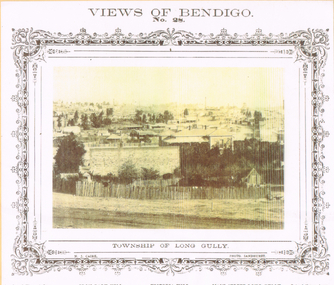 Bendigo Historical Society Inc.
Photograph - LONG GULLY HISTORY GROUP COLLECTION: TOWNSHIP OF LONG GULLY
BHS CollectionYellow tone photo of the Township of Long Gully. At the top is Views of Bendigo No. 28. There is a decorative frame around the photo. The photo has tall chimneys in the background. Iron Bark Hill and Victoria Hill are mentioned. There are houses in the centre and in the foreground is a rough picket fence. It is a N J Caire Photo Sandhurst and a Carey & Wenhorn's Print. Forbes & Holmes, Agents. The photo is mounted on a yellow card which is mounted on a purple card and laminated.bendigo, history, long gully history group, the long gully history group - township of long gully, views of bendigo no 28, casey & wenburn's print, iron bark hill, victoria hill, forbes & holmes, n j caire -
 Kiewa Valley Historical Society
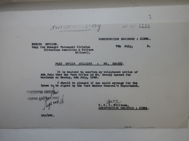
Papers - Mt Beauty Post Office Building
Mt Beauty was built by the SECV during the construction of the KHES. The Mt Beauty Post Office was opened on 4th July 1949The Mt Beauty Post Office is part of Mt Beauty's history. It is still located in the same place and now also sells gifts for the tourists, stationary and clothing.Photocopy of letter re Post Office Building - Mt Beauty advising that the Post Office at My Beauty opened for business on Monday, 4th July, 1949. Also photocopies of 4 official SECV photos - 1. The Mt Beauty township Jan. 1948 2. Exterior of the New Post Office Mt Beauty dated July 1949 and 3. Interior of the New Post Office Mt Beauty dated July 1949mt beauty post office -
 Bendigo Historical Society Inc.
Newspaper - MINING REPORTS - NOTICE OF APPLICATION FOR A MINING LEASE
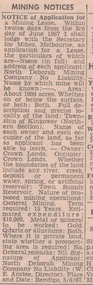
Notice of Application for a Mining Lease from the Bendigo Advertiser 8/6/1967. Proposed lease is for about 1000 acres in the Township of Kingower (Nrthern Section). Owner/occupier - Crown Land, so far as the applicant has been able to learn. Term required 15 years. Applicant was North Deborah Mining Company No Liability (W. E. Anstee, Director). Place and date: Bendigo, 5/6/67.newspaper, bendigo advertiser, mining reports, notice of application for a mining lease, north deborah mining company no liability, w e anstee -
 Ararat & District Historical Society (operating the Langi Morgala Museum)
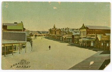
Postcard, Barkly Street Ararat
Barkly Street is the main road into the business district of Ararat and has developed significantly since this image was taken. The postcard helps define the township in its early stages of colonialisation and reflects on the style of early architecture. The image is a photographic representation of wide streets, assorted businesses and buildings with a bicyclist and horse-drawn carriage in the background. The vantage point seems to be the balcony of Leopolds hotel. This early 1900s streetscape assists in the understanding of our township's development over the decades, both socially and architecturally.Small, landscape orientation rigid postcard, colourised, featuring Barkly Street in Ararat, circa 1900s. Notable features are the Turf Hotel sign and the lettering 'Yankee Doodle' on a building wall.Front: "Barkly Street Ararat". barkly street, ararat, 1900s, buildings, streetscape, architecture, postcard, colourised, turf hotel, leopolds hotel -
 Wannon Water
Cast Iron Seal Embossing Press, Seal
Mortlake Waterworks Trust – 18 May 1915 to 1 July 1984 Mortlake Waterworks Trust was constituted on 18 May 1915 following application by the Shire of Mortlake to carry out works for the supply of water to the township of Mortlake. The Trust was abolished on 1 July 1984 under the Water and Sewerage Authorities (Restructuring) Act 1983 when authority was transferred to the Mortlake Water Board. A cast iron seal press. This was used by Mortlake Waterworks Trust to emboss agreements and official documents. Die is still attached to the press. It reads: Mortlake Waterworks Trust 1915. Small metal machine painted black , decorated gold . Dies are attached with the seal of Mortlake Waterworks Trust . Paper is placed between the dies, the handle depressed and the seal embossed on the paper under pressure as a blind (inkless) embossing. The seal consists of two circles with the wording "Mortlake Waterworks Trust 1915". Mortlake Waterworks Trust 1915mortlake, public administration, water supply, amalgamations -
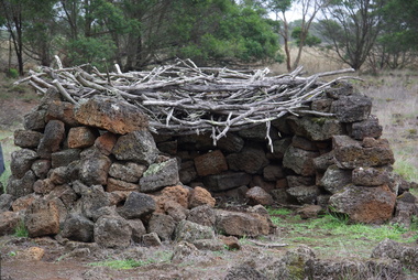 Ballarat Heritage Services
Photograph - Colour, Aboriginal Rock Hut recreations at Tyrendarra, 2016, 16/04/2016
The Budj Bim National Heritage Landscape - Tyrendarra Area on the Australian National Heritage List lies on the Tyrendarra lava flow between the Fitzroy River and Darlot Creek close to the township. The Budj Bim Cultural Landscape was ascribed on the UNESCO World Heritage List on 06 July 2019 (AEST). These photographs were taken during a guided tour with Gunditjmara guide Dennis Rose.Remains of stone shelters built and used by the Gunditj Mirring people.rock shelter, aboriginal, aborigines, tyrendarra, winda mara, rock hut, gunditjmara, unesco world heritage