Showing 3069 items matching "scales"
-
 Northern District School of Nursing. Managed by Bendigo Historical Society Inc.
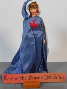
Education kit - St Johns Ambulance Brigade Miniature Doll, Nursing Though the Ages
St John Ambulance Brigade in 1099 the Order of St John of Jerusalem began. Both men and women nursed on a large scale. Both the Knights and Ladies were pledged to the service on mankind. Ther Emblem the eight pointed white cross is still worn by members of the St John Ambulance Brigade. Miniature 30cm doll dresses on blue gown and long matching blue cape. Red insignia front of dress.Dame of Order of St Johnnursing history, nursing uniforms, northern district school of nursing, miniature dopll -
 Moorabbin Air Museum
Machine - De Havilland Ghost Mark 105
Historical Details: . Description: The de Havilland Ghost (originally Halford H-2) was the de Havilland Engine Company's second turbojet engine design to enter production and the world's first gas turbine engine to enter airline (BOAC) service. A scaled-up development of the Goblin, the Gh. Level of Importance: 649440 -
 Melbourne Tram Museum
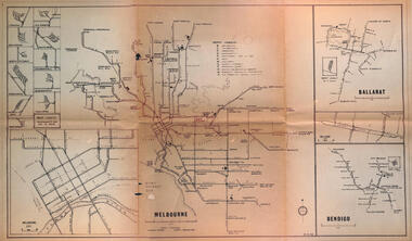
Map - Melbourne - Ballarat - Bendigo Tramways, 23-9-1969
Provides a detailed map of Melbourne, Ballarat and Bendigo tram lines - dated 23-9-1969. Shows street names, depot locations, depot layouts, track details including an insert for Sturt St Ballarat and destination locations. Provides a scale for each system. Not known who prepared the drawing.Yields information about the three operable Victorian systems at the date of preparation.Printed - dyeline? map on a folded sheet of papermap, melbourne, ballarat, bendigo, tramways, diagram -
 Bendigo Military Museum
Administrative record - International Map of the World (IMW) 1:1 Million Scale - H Ureta, Circa 1964, MR H Ereta, Post 1964
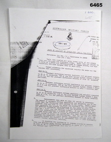
This document records the history of the International Map of the World (IMW) at 1:1Million Scale. Mr H. Ereta, Chief of the Cartographic Section of the United Nations Department of Economic Development and Social Affairs gave a lecture on the IMW and described the history and development of the map series in post 1964. This document is a copy of that lecture. 7 x Foolscap pages of typed text, stapled and two hole punched, Paper is dis-coloured.royal australian survey corps, rasvy, fortuna, army survey regiment, army svy regt, asr, imw -
 Bendigo Historical Society Inc.
Tool - BILL ASHMAN COLLECTION: SCALEBUOY SAMPLE CASE
Leather display case holding scalebuoys belonged to Bill Ashman, who was a salesperson for the Abbott company. A Scalebuoy is a handheld water treatment device, invented by Hartley Abbott and patented under the name of the Bendigo Electronic Company, designed to prevent scale buildup in water vessels and boilers by supposedly "softening" the water. Brown leather case with 2 keys containing 4 scalebuoys of various types and sizes held in a blue velvet holder & a pocket in lid holding 9 publications by W.N.Abbott on the uses of Scalebuoys along with 2 letters attesting to the success of Scalebuoys.scalebuoy, w. abbott -
Moorabbin Air Museum
Document (Item) - Turana - Australia'S Naval Target Aircraft
Description: Seven photos showing Ikara missile on nozzle alignment rig in test, show Woomera Rocket Range SA. Rocket motor nozzle had to be correct angle to body. Last photo is Ikara missile in launcher. Significance: M2 was first full scale pre production missile. Level of Importance: . -
Moorabbin Air Museum
Functional Object - Martin Mariner Wing Section (1)
Historical Details: . Description: In 1937, Martin produced a quarter-scale flying model of a new twin-engined patrol bomber (PB) and a prototype of this experimental flying-boat was completed in February 1939, as the XPBM-1. Twenty production PBM-1s were delivered to the US Navy in 1940-4. Level of Importance: -
Moorabbin Air Museum
Functional Object - Martin Mariner Wing Section (2)
Historical Details: . Description: In 1937, Martin produced a quarter-scale flying model of a new twin-engined patrol bomber (PB) and a prototype of this experimental flying-boat was completed in February 1939, as the XPBM-1. Twenty production PBM-1s were delivered to the US Navy in 1940-4. Level of Importance: -
Moorabbin Air Museum
Functional Object - Martin Mariner Fin
Historical Details: . Description: In 1937, Martin produced a quarter-scale flying model of a new twin-engined patrol bomber (PB) and a prototype of this experimental flying-boat was completed in February 1939, as the XPBM-1. Twenty production PBM-1s were delivered to the US Navy in 1940-4. Level of Importance: -
 Bendigo Military Museum
Administrative record - AHQ Survey Regiment - Tests on stability of duplicate Aerial Photography negatives 1959, AHQ Survey Regiment, 8 Dec 1959
Tests on the stability of Duplicated Aerial Photography negatives. Tests were carried out using 3 x units of 2 x models from both original and duplicate films. These were all brought to a scale of 1;25,000 and horizontalized on common points and approximately 250 spot heights read on each unit.1 x A4 poorly photocopied Report. Typed text and incompleteroyal australian survey corps, rasvy, fortuna, army survey regiment, army svy regt, asr -
 Flagstaff Hill Maritime Museum and Village
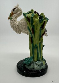
Decorative object - Minton Majolica model of a White Stork, 2001
Royal Doulton as part of the Minton Miniature series produced this stork model in 2001. A limited edition of 1,793 pieces were made, and this stork is number 118. The stork is a scaled down model of the original life-size piece first produced by John Henk, c. 1870, as a walking stick and umbrella stand. A rare miniature stork demonstrates the artistry and skill required to produce Majolica ware during the 19th century and the present.A miniature white stork standing on one leg atop a rocky mound, an eel clasped in its beak, a frog beneath its foot, the stand formed by tall bullrushes & water-lily pads.Inscribed at the base Minton founded 1793, artist mark: 6, made in Englandminton & co., majolica, miniature model, flagstaff hill maritime museum, stoke upon trent, john henk, staffordshire -
 The Beechworth Burke Museum
Geological specimen - Chalcopyrite
This specimen originated from Mount Lyell on the west coast of Tasmania, where a large group of open cut and underground copper-silver-gold mines began operating in 1883. Between 1893-1994, the Mt Lyell Mining and Railway Company were responsible for operations. The Mt Lyell copper-gold mines produce some excellent crystallised specimens of chalcopyrite and other minerals. The deposits are generally considered to be of Cambrian volcanic origin, but there are indications of Devonian granitic influence on the ores, plus local remobilisation during Devonian deformation. Over 120 million tonnes of ore was produced from several workings, including the main Prince Lyell mine and the North Lyell mine, which was also of great importance. The Mount Lyell mines have a long history of human and environmental disasters, including the 1912 North Lyell fire that killed 42 miners, and two separate incidents in 2013 in which three people lost their lives. The environmental impacts from this complex of mines are extensive, with waste tailings and heavy metal contamination flowing directly into the King and Queen River catchments. In 1954, the eminent Australian historian, Geoffrey Blainey, published 'The Peaks of Lyell' which delves into the history of the 1912 North Mount Lyell Disaster.Chalcopyrite does not contain the most copper in its structure relative to other minerals, but it is the most important copper ore since it can be found in many localities and occurs in a variety of ore types. The brassy-yellow colours in Chalcopyrite mean it is often confused with pyrites and gold, leading to use of the term, "fool's gold." Chalcopyrite has been the primary ore of copper since smelting began five thousand years ago. This specimen is part of a larger collection of geological and mineral specimens collected from around Australia (and some parts of the world) and donated to the Burke Museum between 1868-1880. A large percentage of these specimens were collected in Victoria as part of the Geological Survey of Victoria that begun in 1852 (in response to the Gold Rush) to study and map the geology of Victoria. Collecting geological specimens was an important part of mapping and understanding the scientific makeup of the earth. Many of these specimens were sent to research and collecting organisations across Australia, including the Burke Museum, to educate and encourage further study.This hand sized solid mineral specimen has shades of brass-yellow with spots of iridescent green-black tarnish. Chalcopyrite is a copper iron sulphide mineral and a major ore of copper common in sulphide veins and disseminated in igneous rocks. Chalcopyrite has a hardness of 3.5-4 on the Mohs Scale. It is a member of the tetragonal crystal system and has metallic lustre and opaque transparency.burke museum, beechworth, indigo shire, beechworth museum, geology, geological specimen, chalcopyrite, copper pyrites, copper mining, tasmanian geology, mount lyell, mount lyell mines, fools gold, mohs scale, crystals, minerals, historical geological collection, victorian geological survey, a.r.c selwyn, gold rush, van diemans land -
 Bendigo Military Museum
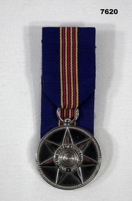
Medal - ANNIVERSARY OF FEDERATION MEDAL 2001
This medal is a full scale replica . It has a mounting ring at the top. Attached to that is a coloured ribbon. The ribbon's main colour is blue. It has 4 yellow vertical, 4 maroon vertical and 6 vertical stripes. The front of the medal shows a raised 7 pointed star with a circle in the centre. The words "Anniversary of Federation 1901-2001". The reverse side is covered by the glued on ribbon. medal, federation australia, 100 anniversary -
 Warrnambool and District Historical Society Inc.
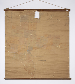
Map - Soldier Settlement Map, Soldier Settlement Commission, Tarrone Estate Alex Boyd, 1940s
This is a map of the Tarrone Soldier Settlement land divisions probably produced by the Soldier Settlement Commission. The map is incomplete with lots 48,49 and 50 missing. The Soldier Settlement Commission purchased 23,373 acres of Tarrone Station from the Boyd brothers in 1947 and the sub divided lots were occupied by soldier settlers commencing in 1949. Tarrone Station was established in 1840 by Doctors Kilgour and Bernard and the Boyd brothers secured the free hold in the 1890s and retained it until 1947. The map hung for many years in the Warrong school near Hawkesdale.This map is of considerable interest as an original item from the establishment of the Tarrone Soldier Settlement..The map is made of brown cloth and creased. The edges are tattered and there is a piece missing at the top. It is a map of allotments, hand drawn and with faded colours in red, blue and yellow. The names of localities and land holders are hand written in ink and chalk. The map is contained within two pieces of wood at the bottom and the top. There are two screws and a cord to hang on a wall. A scale of measurement is shown under the map. tarrone soldiers settlement, boyd brothers tarrone -
 Wycheproof & District Historical Society Inc.
Bunguluke Map, Bunguluke District In 1923, 27.2.1923
By 1881 Bunguluke was a small settlement as recorded, December 5, in the Charlton "Mercury". It reports that in that year Draper's Store, Hotel and Post Office and residence at Bunguluke North was totally destroyed by fire. For years now there has been little sign of community life with houses few and far between and acreages have gone into larger holdings. The map references land blocks and owners for that era.This important map shows the local land ownership and local features that existed in 1923. This is a photocopied black and white map of Bunguluke in the County of Kara Kara, Number L5149. Marked - Photo Lithographed by W.J. Butson 27.2.1923. The details include numbers of allotments, property owners, roads, rivers. The boundaries marked are the Parish of Jeruk, Parish of Wycheproof, Parish of Cooroopajerrup. Wycheproof township location is shown with the Scale of Chains. Bunguluke maps for other years are also in the collection.map, bunguluke, jeruk, wycheproof, cooroopajerrup -
 Federation University Historical Collection
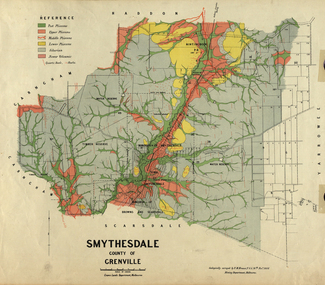
Map, Smythesdale, County of Grenville, 1888, 1889
The map maker, Ferdinand M. Krause, was a professor at the Ballarat School of Mines. This land was printed form the Crown Lands Department, Melbourne. Coloured map of the County of Grenville. The edge has been taped. The scale is 40 chains to 1 inch. The map is accompanied with a foolscap sheet printed by the Mines Department in 1898. It is a Report on the Parish of Smythesdale by F.M. Krause and includes information on the water reserve, worked quartz veins, Watson's Hill, Surface Hill and Sugarloaf Hill, Haddon, Trunk Lead and the Crucible Shaft. smythesdale, krause, f.m. krause, ferdinand krause, nitingbool, watson's hill, surface hill, sugarloaf hill, haddon -
Bendigo Historical Society Inc.
Map - CAMPBELL COLLECTION: BENDIGO AND DISTRICT MAPS
Map. Ascot Unit, scale 20 chains to an inch, arrow pointing to magnetic north, road to Fosterville to the East, Huntly 3/4 mile to the West, road to Epsom 3/4 mile and road to Bendigo 4 1/2 miles south west on map, also on page is the Northern Railway (Bendigo to Echuca) line. (number 355 in map cupboard 1)map, bendigo, country lands -
 Bendigo Historical Society Inc.
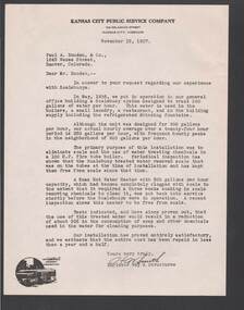
Document - BILL ASHMAN COLLECTION: CORRESPONDENCE
Five copies of a letter from ? Smith, Engineer Way & Structures, of the Kansas City Public Service Company to Paul A. Douden & Co., dated November 15, 1937. He tells of their experiences with Scalebuoys. He mentions reduction of scale and about a 30% reduction in the consumption of soap and the chemicals used in the water for cleaning purposes. In the bottom left corner is a small picture of a bus and a tram.sciences, instruments - general, scalebuoy, bill ashman collection - correspondence, kansas city public service company, paul a douden & co, ? smith -
 Bendigo Historical Society Inc.
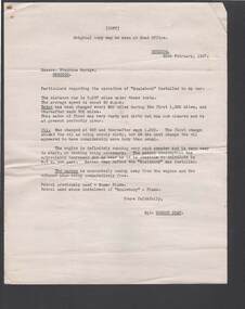
Document - BILL ASHMAN COLLECTION: CORRESPONDENCE
Copy of a letter, dated 20 February, 1937, to Stephens Garage from Gordon Gray. He details the operation of his car after the installation of Scale Buoy. He mentions Water, Oil and petrol consumption. Also mentioned is carbon and exhaust. He also mentions that he used Super Plume Petrol and since the installation of 'Scalebuoy' he then used Plume Petrol.sciences, instruments - general, scalebuoy, bill ashman collection - correspondence, stephens garage, super plume petrol, plume petrol, gordon gray -
 Bendigo Historical Society Inc.
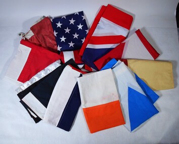
Textile - Flags
The Red Ribbon Agitation took place in Sandhurst in 1853 when the miners protested against the Licence fee imposed by the Government.Replicas of various flags used during the Red Ribbon Agitation (1853) re-enactments. There are flags of Scotland, Ireland, France, Germany, Canada, Switzerland, USA, Union Jack and two St Piran's Flag of Cornwall. The Red Ribbon replica flag has four segments: Gold Scales, Emu/Kangaroo, Pick/Shovel and Gold Cradle and a Roman bundle of sticks.flags, red ribbon agitation -
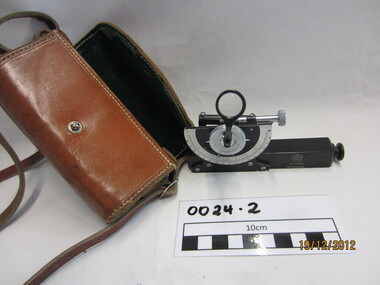 Wannon Water
Clinometre / Abney Level, E. R. Watts & Son, Clinometre
Abney Level / Clinometer is an accurate surveying tool used to measure degrees, percent of grade and topographic elevation. Used for surveying pipe lines.Instrument which consists of a fixed sighting tube, a movable spirit level connected to a pointing arm which turns and pivots. Adjustment knob/screw on top turns to rotate the compass indicator and bubble level. Arched scale graduated 0 to 90 degrees in both directions. Clinometer is housed in a brown leather case with a long leather strap for carrying around the neck.Watts London / No 70131 / Made in England -
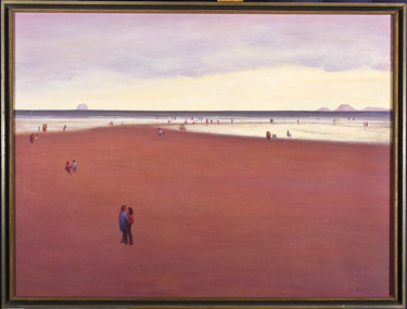 Nillumbik Shire Council
Painting: David ARMFIELD (b.1923 Melb AUS - d. 2010 Melb AUS), David Armfield, Untitled (Beach), c. 1975
David Armfield studied at the National Gallery School in the 1940s and turned to full time painting in 1965. RMIT printamking. He has won several art awards, including the Ramsay Prize - NGV School, the Redcliffe and in 1980 the Eltham Prize. Armfield is represented in the National Gallery collection, Art Gallery of NSW, Tasmanian Art Gallery, several regional art galleries across Australia as well as private collections. David Armfield first came to Eltham in the late 1903s on painting trips and used to camp on the banks of the Diamond Creed. He returned to Eltham in 1957 with his wife Joan who has subsequently become one of the district's potters, and built a mud brick house and studio in John Street on land adjoining Peter Glass. He has painted many landscapes in the district including intimate studies of the bush floor and the aftermath of bush fires.'Untitled' by David Armfield an oil on canvas painting depicts sand, sea, distant mountains and various figures scattered about in a typical Armfield landscape. The figures tend to be annonymous, sometimes included more to establish the scale than for a narrative purpose. The figures are well clothed and it could be assumed that it is not a hot summer's day. Depth is established by changing of colours and diminishing the size of the figures.david armfield, beach, eltham, nillumbik shire council -
 Mont De Lancey
Book, Union Tune Book, Unknown
An introduction to singing prepared with a view to assist those who wish to acquire a sufficient knowledge of the science to sing the praises of God correctly; and also to encourage the cultivation of vocal music in schools. It is of use for beginners.A very damaged antique brown and black covered introduction to singing music book. The title page is missing. The spine has four double gold bands with the title printed in gold lettering. It has 319 songs or hymns included as well as Preliminary remarks addressed to learners, musical characters, intervals, time, diatonic scale, major and minor modes or keys and transposition.non-fictionAn introduction to singing prepared with a view to assist those who wish to acquire a sufficient knowledge of the science to sing the praises of God correctly; and also to encourage the cultivation of vocal music in schools. It is of use for beginners.music books, singing books, singing -
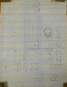 Bendigo Historical Society Inc.
Plan - MARKS COLLECTION: PLAN EXTRA BOILER LANSELL'S 180 MINE
Engineering drawings for the (written on bottom of plan) 'No 2-arrangement extra boiler for Lansells Proprietary little 180 Mine Bendigo Plan shows chimney - side elevation, measurements of chimney, flue, boiler (and existing boiler, existing loco boiler) On bottom of plan: Scale 1/4 inch = 1 foot. Hargreaves & Daggar, Consulting Engineers, Victoria Chambers, Bendigo.mining, equipment, lansell's little 180 mine -
 Bendigo Historical Society Inc.
Document - MARKS COLLECTION: SECTION OF MAIN CHANNEL
Plan drawn on waxed type paper, fragile. Written in centre of map 'Section on Centre of Main Channel, Scale horizontal 2 chs, vertical 10ft., to an inch'. Plan shows Melbourne Road on top section. Written in red ink '5,000,000 galls in 24 hours = 3472.2 gals per minute'. Plan located in documents from George Lansell auction.bendigo, mining, water channel section -
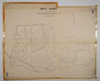 Bendigo Historical Society Inc.
Map - CAMPBELL COLLECTION: BENDIGO AND DISTRICT MAPS
Map. Rifle Range, Parishes of Wellsford and Sandhurst. Scale 20 chains to 1 inch. Total area in plan is 5916 acres. Wallan and Bendigo Railway to Axedale Township and station 8 miles, to Longlea Railway Station 2 1/2 - 3 miles. Rifle Range. Compiled in W.P.B. from Assessment and Parish Plans, by H.A.D. 8-7-29H.A.D.(Darby).map, bendigo, allotments, bendigo rifle range, sandhurst parish, wellsford parish -
Federation University Historical Collection
Book, W. Abbott, Practical Geometry and Engineering Graphics: A Textbook for Engineering Students, 1944
... scales ...Green hard cover book of 316 pagesnon-fictionengineeing, rex hollioake, m.f. murray, geometry, drawing, scales, moving mechanism, velocity, acceleration, solids, projection -
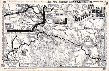 Marysville & District Historical Society
Ephemera (Item) - Pocket card map, Broadbent's Official Road Guides Company, Broadbent's Map No. 163 Marysville & District, 1950s
A pocket card map of Marysville and the district. Drawn map of Marysville and the district. Has a legend, scale and a town map of Marysville. Gives an address for Broadbent's Publishing Office of 475 Collins St Melbourne and a Melbourne telephone number - MR 2021. Reverse has advertisements for Barton's Store and Marylands Guest House in Marysville.A pocket card map of Marysville and the district. Gives information about Marysville and the district. Broadbent's was a prolific publisher of maps. marysville, victoria, maps, broadbent's, barton's store, marylands guest house -
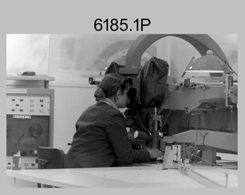 Bendigo Military Museum
Photograph - Capturing Topographic Features with a Wild B8 – Army Survey Regiment, Fortuna, Bendigo, c1980
These four photographs of SPR Santina (Argetto) Straube capturing topographic features – plotting with a Wild B8 stereo plotter were most likely taken in c1980. Introduced in 1966, the Wild B8 stereo plotter was used for plotting topographic detail and contours. These analogue machines were manually controlled by adjusting the control knobs for the orientation of the 3D image. The B8s used a nine-inch square photo image on a film or glass diapositive which allowed highly accurate extraction of map features. At first, plotting by B8 and B9 equipment was undertaken at the aerial photography scale of 1:80,000 in pencil onto a controlled plotting sheet. Sheets were then inked up and reduced photographically to the 1: 100,000 publication scale for scribe impression production. In these photos SPR Santina (Argetto) Straube was plotting with a pencil or ink pen mounted at the far end of the pantograph arm. The plotting procedure was upgraded to direct plotting in ink with photographic reduction to publication scale. In 1975 four B8s were upgraded with tri-axis locaters as part of the Input Sub-system to enable digital extraction to AUTOMAP 1’s topographic database. When AUTOMAP 2 was introduced in 1982 these B8s were upgraded, and additional machines added to expand the Army Survey Regiment’s digital capture capability. This is a set of four photographs of a technician capturing topographic Features with a Wild B8 stereo plotter in Air Survey Squadron – Army Survey Regiment, Fortuna, Bendigo. 1980. The photographs were on 35mm negative film and were scanned at 96 dpi. They are part of the Army Survey Regiment’s Collection. .1) to .4) Photo, black & white, c1980. SPR Santina (Argetto) Straube operating a Wild B8 stereo plotter..1P to .4P – no annotations.royal australian survey corps, rasvy, army survey regiment, army svy regt, fortuna, asr, air survey, photogrammetry -
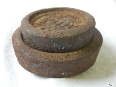 Flagstaff Hill Maritime Museum and Village
Equipment - Weight
The disc-shaped design of these 1LB and 2 LB metal weights enables them to be stacked one on top of the other. The weights are used with a balance scale to accurately weigh the mass of items such as grain, sugar, meat or potatoes. They could have been used in retail or wholesale businesses like a general store or a grain merchant’s premises. The user would place either one or both of these weights on one side of a balance scale. Goods would then be placed onto the other side of the scale until the beam between both sides of the scale was level, showing that the weight of the goods was as heavy as the weight or weights on the other side. These two weights are marked in Imperial units. An Imperial Standard 1LB is equal to 453.592grams. The British Weights and Measures Act of 1824 defined official standards for weights and measurements. This ensured that uniform measurements would be used for trade throughout the Empire. Towns and districts would have an official set of Imperial Standard Weights and Measures. Inspectors periodically used this official set to check the accuracy of traders’ own weights and measures. There would be penalties such as fines or imprisonment for people who broke these laws. The State of Victoria had its own Weight and Measures Act in 1862 and a decade later the inspectors in local councils used their local set of weights and measures to test the local businesses measuring equipment. In the nineteenth century the Victorian Customs Department carried out this role but this was handed over to the Melbourne Observatory at the beginning of the twentieth century. The Measures Branch then followed on with this task from the 1940s until 1995. Australia began converting to the metric system in the 1960s, beginning with its money. The conversion from imperial to metric units of measurement in Australia took place from 1970 and was completed in 1988 when metric units became the only legal unit of measurement. Imperial Standard weights; set of two disc-shaped weights designed to stack one upon the other. Inscriptions are marked in relief. "IMPERIAL STANDARD 1LB" [weight 1], "IMPERIAL STANDARD 2LB" [weight 2]warrnambool, shipwrecked-coast, flagstaff-hill, flagstaff-hill-maritime-museum, maritime-museum, shipwreck-coast, flagstaff-hill-maritime-village, shipwrecked-artefact, wieght, weights and measures, imperial standard weight