Showing 1504 items
matching building works
-
 Kew Historical Society Inc
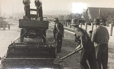
Photograph, City of Kew, Public Works, Road Construction, c.1920s
An original photograph donated to the Kew Historical Society by the City's Engineering Department before the amalgamation of Kew into the City of Boroondara in 1994.While not all of the photographs are of Studley Park, Kew or East Kew, each photo provides a fine snapshot of the work of local government engineering departments of the period. They reveal they types of labour conducted, the techniques used and the equipment and machinery in the possession of the local government authority. Public works. A close-up photograph of a grader being pulled by a truck. road construction building, city of kew, city of kew (engineering department), bituminising, grader -
 Kew Historical Society Inc
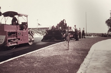
Photograph, Public Works, Road Construction, 1950s
An original photograph donated to the Kew Historical Society by the City's Engineering Department before the amalgamation of Kew into the City of Boroondara in 1994.While not all of the photographs are of Studley Park, Kew or East Kew, each photo provides a fine snapshot of the work of local government engineering departments of the period. They reveal they types of labour conducted, the techniques used and the equipment and machinery in the possession of the local government authority. Public works. Road making in the 1950s using a steam roller and a mechanical grader. Inscription on reverse: "Road making." city of kew (engineering department), road construction building, road maintenance -
 Kew Historical Society Inc
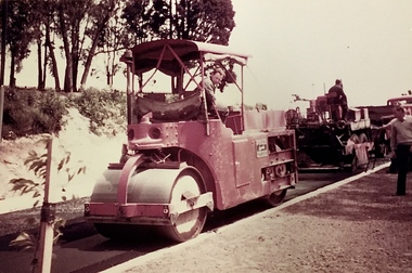
Photograph, Public Works, Road Construction, 1950s
An original photograph donated to the Kew Historical Society by the City's Engineering Department before the amalgamation of Kew into the City of Boroondara in 1994.While not all of the photographs are of Studley Park, Kew or East Kew, each photo provides a fine snapshot of the work of local government engineering departments of the period. They reveal they types of labour conducted, the techniques used and the equipment and machinery in the possession of the local government authority.Public works. Roadmaking in the 1950s using a steam roller. Inscription on reverse: "Road making. Date?" city of kew (engineering department), road construction building -
 RMIT GSBL Justice Smith Collection
Book, Fricke, Graham L, Tales from the courts, 1999
ISBN: 0734400063trials -- victoria, judges -- victoria, judicial process -- victoria -- popular works, judges -- australia -- victoria, judicial process -- australia -- victoria -- popular works, trials -- australia -- victoria -
 Kew Historical Society Inc
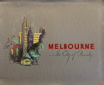
Booklet, Melbourne ... The City of Beauty, 1930s
Pictorial tourist folio of the City of Melbourne including black and white and colour photographsCover shows Collins Street with tram, Town Hall and Manchester Unity building. [24] p. : all ill. (some col.) ; 22 x 27 cmnon-fictionPictorial tourist folio of the City of Melbourne including black and white and colour photographsmelbourne (vic.) -- pictorial works, christian-washfold collection -
 Kew Historical Society Inc
Map, Department of Lands & Survey, Map of Melbourne & Suburbs, 1899
The Melbourne & Metropolitan Board of Works was established in 1891 to oversee the introduction of a sewerage and water reticulation system in Melbourne and its suburbs. This complementary map was produced by the Department of Crown Lands & Survey [Victoria] in the same decade showing the distribution of water in Melbourne for use by fire brigades. While by 1910, there were 123,227 connections to Melbourne's water supply system, it is unclear in this 1899 map whether water was supplied to all built structures in the defined areas or only to fire hydrants and stand pipes, as we know that the first connection of a building to the sewerage system in Kew only occurred in 1904.Map accompanying report on fire protection of Melbourne showing those areas supplied with water in colour.water reticulation -- melbourne (vic.), department of lands & survey -- historic maps, fire brigades -- melbourne (vic.), cartography -
 Kew Historical Society Inc
Map, MMBW, River Yarra Beautification Schemes, c.1913
The Melbourne and Metropolitan Board of Works (MMBW) was established by an act of the Victorian Parliament in 1890 to prepare for and to implement a sewerage and water reticulation system across what was then inner Melbourne, its surrounding and middle distance suburbs, including Kew. The MMBW was disbanded in 1991.The map collection of the Kew Historical Society has at its core the historic maps assembled and originally stored in the City Engineer's Department of the City of Kew. These include maps in a number of scales. The vast majority of maps were produced by the MMBW in the first two decades of the twentieth century, and are solid working maps, backed by linen for durability. These maps are historically significant to Kew, the City of Boroondara and to the history of the development of state utilities in Victoria. A number of the Kew maps have additional details added by former municipal officers, including the levels reached by various floods. As these were working documents, information was added to them long after the period of their initial production and distribution.Map of the City of Kew showing part of the River Yarra Beautification Schemes. The map shows development to date and the flood levels reached in 1923 and 1924. This map may have been adapted from an earlier map, as most development in central Kew and Studley Park had occurred by this date yet numerous streets are not represented. Public buildings and institutions are clearly represented and named on the map as are significant public transport infrastructure (eg the Outer Circle railway).MELBOURNE AND METROPOLITAN BOARD OF WORKS / RIVER YARRA BEAUTIFICATION SCHEMES / SCHEME / SCALE 10 CHAINS TO AN INCHmelbourne & metropolitan board of works, mmbw maps, mmbw plans, city of kew, flood levels -- kew (vic.), cartography -
 Kew Historical Society Inc
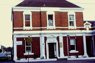
Slide - Kew Police Station, High Street, 1976
Colour transparency (slide) created in June 1976 during a tour by the Junior National Trust, which was led by members of Kew Historical Society. The collection of 21 slides reveals that the tour covered all parts of Kew, but focused understandably on heritage buildings and sites.Image of an historic place in Kew that can be dated to an exact time and place. The images, albeit amateurish in composition, frequently reveal aspects of important buildings and sites that have changed over time.35mm colour transparency of the former Kew Police Station (closed 2002) in High Street, Kew. The original structure was built as a house for the resident police sergeant and his family. Offices and a cell block were located at the rear of this building. The Queen Anne revival style employed by the Department of Public Works architects, favoured the use of red brick highlighted by stucco. The painted white stucco is not the original colour. The building is part of a suite of public offices opened in 1888.public offices -- kew (vic.), police stations -- kew (vic.) -
 Kew Historical Society Inc
Photograph - High Street, Kew, 1960-65
The borders of the main components of Kew and Kew East have not always conformed to current boundaries. In the past this photograph has been labelled as East Kew, whereas for most of the twentieth century the site has been within Kew's borders. The purpose of the photograph is unrecorded yet it has value in that it shows those businesses who occupied this site in Kew during the early 1960s.This small photograph is significant as it shows the location of and building used by WD Vaughan, former Mayor of Kew who was a successful newspaper proprietor in Melbourne.Small polaroid colour positive of High Street in Kew, probably in the 1960s. From left we can see the brick viaduct covering the tracks of what was once the Outer Circle Railway. Behind this brick wall, Dunnings Timber Yard was situated. At the end of the walls of the viaduct there is an entrance to a walkway [now the Anniversary Trail], which once provided access to Windsor Avenue, and also to the East Kew Station (now demolished and part of the Outer Circle Railway Reserve). On the other side of this walkway is a cream brick building (demolished) occupied at this time by WD Vaughan Pty Ltd, printer and publisher of the Kew Advertiser (newspaper). Stretching behind the brick facade is an extensive building that must have housed the printing works. Beside Vaughan's, there is a large building (demolished) housing at that time an estate agent named AJ Kennedy. This area is now separated by kerbing.High St East Kew / Corner of Harp Rd. / Looking South -
 Kew Historical Society Inc
Photograph - Denmark Street, Kew, 1972
The Engineer's Department of the former City of Kew had an extensive collection of photograph of sites in Kew requiring documentation to inform public works. It also kept images of engineering practice in other parts of Melbourne, and overseas, that could be used as models for local activity. Many of these photographs (and plans) were donated to our collection in the 1980s. A number of the photographs are annotated, either on the image itself or on the reverse.This photograph, and others sourced from the City Engineer's Department of the former City of Kew, qualifies as an important record of local streets, public works, street beautification, and engineering techniques of the period. Original black and white photographic positive of automobiles and buildings in Denmark Street, Kew, immediately before the road enters Kew Junction. On the left is McKeon Motors and a retailer of Insulwool, while in the distance is the pharmacy on the corner of High Street and Princess Street (later demolished during the widening of Kew Junction). Notable are the bluestone guttering and what appears to be vacant land on the apex of the triangle of land bounded by High Street South, Denmark Street and Barkers Road. This site was the original location of O'Shaughnessy's 'Kew Hotel', and after the destruction by fire of the latter, the location of a service station. [It is now the site of the Cresco Reserve].Annotation verso: "Indicating the existence of a vehicular entrance at Denmark St abuttal of No.188 High St prior to reconstruction of channeling &c 1972."denmark street -- kew (vic.), kew junction, luestone gutters, mckeon motors, insulwool -
 Kew Historical Society Inc
Photograph - Kew Main Drain, 1984
... of Works in building the Kew Main Drain, before its reconstruction ...'Kew, Kew East, Balwyn & Balwyn North are located approximately 7km north east of Melbourne. Four main stormwater drains service the area flowing from south to north. Three of the drains: Deepdene Drain; Balwyn Drain & Glass Creek converge in Kew East just west of Burke Road at Kew High School before discharging into the Yarra River. The fourth drain, Kew Main Drain connects directly with the Yarra River to the West of Glass Creek.' The Kew Main Drain is a barrel drain that was created in the 1930s, and follows the route of the former Connor's Creek from the vicinity of Genazzano FCJ College to the Yarra River in East KewImportant and verifiable evidence of the construction methods used by the Melbourne & Metropolitan Board of Works in building the Kew Main Drain, before its reconstruction in c.1985.Original print colour positive photograph of the Kew Main Drain, provided on 14/12.84 to the Chief Engineer of the City of Kew, Ian Poulter, by the Supervising Engineer (Works), Southern and Eastern Drainage, Melbourne & Metropolitan Board of Works. The record includes an image of the reverse as well as the donation document from the MMBW."A84/1855-9 / 750mm council drain looking D/S [down stream] and across Parkhill Road. To be replaced with 1200 mm R.C.P. [reinforced concrete pipe] as part of MMBW Kew Main Drain reconstruction works"kew main drain, stormwater drains -- kew (vic.), connor's creek -- kew (vic.) -
 Kew Historical Society Inc
Photograph - Kew Main Drain, 1984
... of Works in building the Kew Main Drain, before its reconstruction ...'Kew, Kew East, Balwyn & Balwyn North are located approximately 7km north east of Melbourne. Four main stormwater drains service the area flowing from south to north. Three of the drains: Deepdene Drain; Balwyn Drain & Glass Creek converge in Kew East just west of Burke Road at Kew High School before discharging into the Yarra River. The fourth drain, Kew Main Drain connects directly with the Yarra River to the West of Glass Creek.' The Kew Main Drain is a barrel drain that was created in the 1930s, and follows the route of the former Connor's Creek from the vicinity of Genazzano FCJ College to the Yarra River in East KewImportant and verifiable evidence of the construction methods used by the Melbourne & Metropolitan Board of Works in building the Kew Main Drain, before its reconstruction in c.1985.Original print colour positive photograph of the Kew Main Drain, provided on 14/12.84 to the Chief Engineer of the City of Kew, Ian Poulter, by the Supervising Engineer (Works), Southern and Eastern Drainage, Melbourne & Metropolitan Board of Works. The record includes an image of the reverse as well as the donation document from the MMBW."A84/1855-10 / 750mm council drain looking U/S [up stream] from Parkhill Road, Kew."kew main drain, stormwater drains -- kew (vic.), connor's creek -- kew (vic.) -
Kew Historical Society Inc
Book, Oxford University Press, Early Melbourne Architecture 1840 to 1888, 1966
... -- pictorial works melbourne (vic.) -- buildings structures etc ...184p. : chiefly ill. ; 24cm. non-fictionbuildings of historical importance -- architectural features -- melbourne 1840-1888 --illustrations, architecture -- victoria -- melbourne -- pictorial works, melbourne (vic.) -- buildings, structures etc. -- pictorial works -
 Queen Victoria Women's Centre
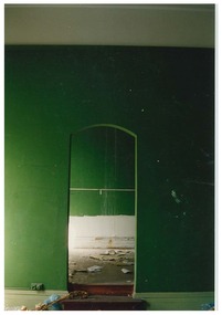
Photograph, c.1995
Colour photograph. Ground floor before demolition works and restoration. Green archway door leading into a green room. historic buildings, cultural structures and establishments -
 Queen Victoria Women's Centre
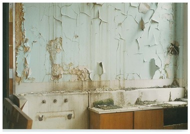
Photograph, c.1995
Colour photograph. Ground floor before demolition works and restoration. Counter top and pealing blue wall paint. cultural structures and establishments, historic buildings -
 Queen Victoria Women's Centre
Photograph, c.1995/1996
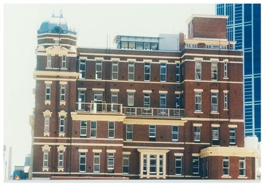
Colour photograph. The eastern exterior views of the QVWC during renovations facing west. Taken before or during restoration works.historic buildings, cultural structures and establishments, building construction -
 Queen Victoria Women's Centre
Photograph, c.1995/1996
Colour photograph. Taken from level four foyer into the Victoria room south and towards Lonsdale street during restoration works inspection.building construction, historic buildings -
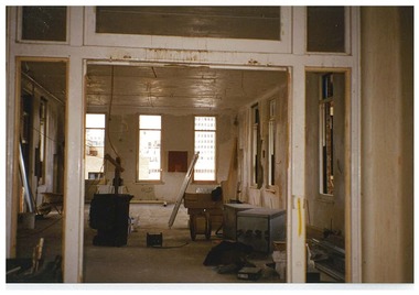
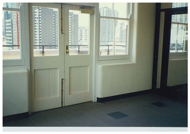
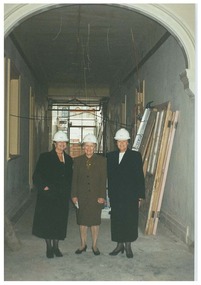 Queen Victoria Women's Centre
Photograph, c.1995
Ground floor corridor duing restoration works. Three women stand under the arch in white hard hats during a tour of the building. Left to right: Architect Yvonne von Hartel, Minister for Women's Affairs Jan Wade, and Minister for the Arts Lorraine Elliot.historic buildings, official events, parliamentary representatives, architects -
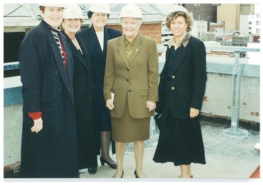 Queen Victoria Women's Centre
Photograph, c.1995
Colour photograph. Rooftop during restoration works. Five women standing by the south east turret in white hard hats during a tour of the building. Left to right: Chair Janet England, Minister for the Arts Lorraine Elliot, Architect Yvonne von Hartel, Minister for Women's Affairs Jan Wade, General Manager Glenys Sharma. official events, historic buildings, parliamentary representatives, architects, building construction -
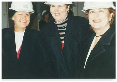 Queen Victoria Women's Centre
Photograph, c.1995
Colour photograph. Possibly in the ground floor corridor during restoration works. Three women facing the camera in white hard hats. Left to right: Architect Yvonne von Hartel, Chair Janet England, Minister for the Arts Lorraine Elliot. parliamentary representatives, historic buildings, building construction, architects -
 Queen Victoria Women's Centre
Photograph, c.February 1997
This angle is no longer possible due to the QV Melbourne buildings that were erected in 2000Colour photograph. Eastern side of the QVWC building's eastern side after restoration works has been completed. building construction, historic buildings, cultural structures and establishments -
 Queen Victoria Women's Centre
Photograph, c.February 1997
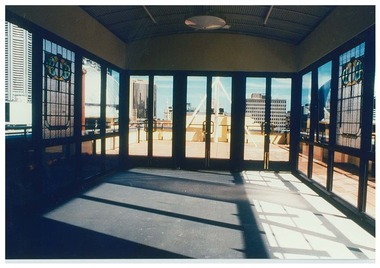
Colour photograph. From level five atrium after completion of renovation works. Taken from the north of the Atrium facing south over Lonsdale street. historic buildings, cultural structures and establishments -
 Queen Victoria Women's Centre
Photograph, c. February 1997
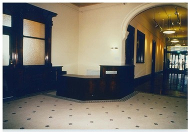
Colour photograph. Ground floor of QVWC building, facing north west towards the reception desk and down the corridor towards the northern foyer, stairwell and lifts. Two people in background in north foyer. Taken after restoration works had been completed. historic buildings, cultural structures and establishments -
 Queen Victoria Women's Centre
Photograph, c.1997
Colour photograph. Interior of level 5 atrium after renovations works have been competed. Taken facing south west. There is a room divider in the foreground, left of frame. Stained glass window seen in background. historic buildings, cultural structures and establishments, christmas, official events -
 Queen Victoria Women's Centre
Photograph, c.1998
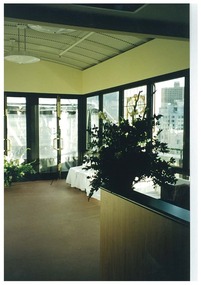
Colour photograph. Interior of level five foyer. Facing east. White painted double doors lead to exterior rooftop garden. Taken after restoration works have been completedhistoric buildings, cultural structures and establishments -
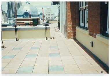 Queen Victoria Women's Centre
Photograph, c.1997
Colour photograph. Roof top exterior, taken on the eastern side towards the south of the building. South eastern turret in frame. Taken after restoration works had been completedhistoric buildings, cultural structures and establishments -
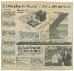 Queen Victoria Women's Centre
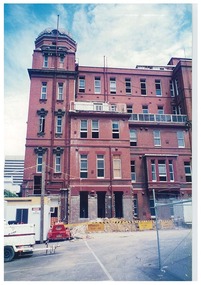
Newspaper clipping, Wayne Taylor, $600m plan for Queen Victoria site unveiled, 21 February 2001
Unveiling of the QV plans by Groconnewspaper clipping from The Age. Graphic representing the works to be done on the QV block between Swanston street and Russell street. Black and white photo at the bottom of page of Premier Steve Bracks with director of Grocon, Daniel Grollo after the plans for QV were announced. building construction, historic building, civic centres, town planning -
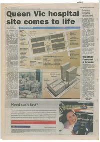 Queen Victoria Women's Centre
Newspaper excerpt, Queen Vic hospital site comes to life, 24 August 2003
newspaper articles Sunday Herald Sun page 28. colour photograph of the construction works bottom left of article's images. Graphic images of the the construction works and what would be included in the centre.town planning, historic building, retail trade, restaurants, construction and demolition workers -
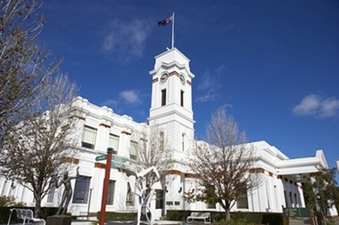 Glen Eira City Council History and Heritage Collection
Photograph - Building, Glen Eira Town Hall, 1884
Originally known as Caulfield Shire Hall, the original 1884 building was designed by Shire surveyor Sydney Smith. In 1931 the Caulfield Town Hall, as it was then known, was remodelled to include the main hall and foyer and a Neo-Grecian portico with Corinthian Order columns. Major works completed since 1945 include Caulfield Arts Complex (opened 20 August 1988), Caulfield Library (opened 4 December 1993) and the award-winning Caulfield Municipal Offices extension which opened on 24 February 1991. The building is listed as No. H0106 in the GECC Heritage Overlay Schedule. The site also includes a Significant Tree (H&H Register No. 034). Brick exterior of two storey building painted white and featuring pillared portico entrance and solid glass doors on Glen Eira road facing north. On the eastern side of the portico is a two storey clock tower with clock surmounted by a flagpole and flag. Some of the eastern section of the building is original with various alterations over the years. The award winning service centre and offices in the westerly aspect of the town hall were extended on to the original buliding in 2000.building, town hall, council, local government, caulfield, glen eira, moorabbin, sydney smith -
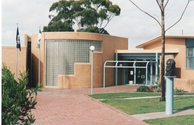 Sunbury Family History and Heritage Society Inc.
Photograph, c1985
The photograph shows the extensions that were built on to the former Shire of Bulla offices in the mid 1980s. The building with the curved wall and glass tiles was where the Shire of Bulla held their council meetings. The Victorian state flag and the Shire of Bulla flags are hoisted on the poles and the bust of George Evans, an early European settler in the district is on the RHS of the image. The extensions completed in the 1980s to the former Shire of Bulla offices were the last major works to be undertaken on the building before Bulla Shire became part of Hume City Council in 1994.A coloured photograph of a brick paved path leading to a cream brick community building with two flags hoisted on flagpoles near the entrance . The bust of a man is visible on the RHS of the image. shire of bulla, council offices, shire of bulla council offices., george evans