Showing 3069 items matching "scales"
-
 Flagstaff Hill Maritime Museum and Village
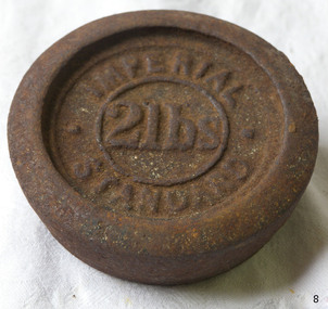
Equipment - Weight
The disc-shaped design of this 2 LB metal weight enables it to be stacked on top of another similarly shaped weight. The weight is used with a balance scale to accurately weigh the mass of items such as grain, sugar, meat or potatoes. It could have been used in retail or wholesale businesses like a general store or a grain merchant’s premises. The user would place the weight on one side of a balance scale. Goods would then be placed onto the other side of the scale until the beam between both sides of the scale was level, showing that the weight of the goods was as heavy as the weight on the other side. This weight is marked in Imperial units. An Imperial Standard 1LB, or one pound, is equal to 453.592grams. The British Weights and Measures Act of 1824 defined official standards for weights and measurements. This ensured that uniform measurements would be used for trade throughout the Empire. Towns and districts would have an official set of Imperial Standard Weights and Measures. Inspectors periodically used this official set to check the accuracy of traders’ own weights and measures. There would be penalties such as fines or imprisonment for people who broke these laws. The State of Victoria had its own Weight and Measures Act in 1862 and a decade later the inspectors in local councils used their local set of weights and measures to test the local businesses measuring equipment. In the nineteenth century the Victorian Customs Department carried out this role but this was handed over to the Melbourne Observatory at the beginning of the twentieth century. The Measures Branch then followed on with this task from the 1940s until 1995. Australia began converting to the metric system in the 1960s, beginning with its money. The conversion from imperial to metric units of measurement in Australia took place from 1970 and was completed in 1988 when metric units became the only legal unit of measurement.Weight; 2 lbs. Metal disc designed for stacking. Inscription marked in relief. Imperial Standard weight, 2 pounds weight."IMPERIAL STANDARD", "2lbs"flagstaff hill, warrnambool, shipwrecked coast, flagstaff hill maritime museum, maritime museum, shipwreck coast, flagstaff hill maritime village, great ocean road, standard measure, imperial standard, weight, 2lb weight, imperial standard weight -
 City of Moorabbin Historical Society (Operating the Box Cottage Museum)
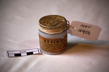
Manufactured Glass, jar 'Resinol' ointment, mid 20th C
Resinol is used to treat several different types of skin ailments. Resinol was developed by Dr. Merville Hamilton Carter (1857-1939) in his private practice as treatment for his patients in Baltimore, Maryland during the late 19th century. In 1895, Carter, along with his brother Allan L. Carter and his cousin Henry Stier Dulaney founded the Resinol Chemical Company and began to mass-produce the ointment and other medical products. After over forty years of selling Resinol, the company had John H. Buffham & Co. as an outlet in Great Britain and was a successful global distributor. Henry LeRoy Carter Sr., the son of Dr. Carter, began running the company after the deaths of his father and other staff members. The company's sales began to decline in the 1940s, and after the death of Henry LeRoy Carter Sr. in 1951, his son Henry LeRoy Carter Jr. took the place of his father and grandfather as president of the Resinol Chemical Company. At that time, the company focused more on soap manufacturing, but continued to sell Resinol. For the rest of the 20th century, Resinol's popularity continued to dwindle. It was purchased by ResiCal Inc. in 2002.A clear glass jar with a metal screw top containing 'Resinol' antipruritic and sedative ointment. Lid : ‘RESINOL’ / ( Ungt Resinol) / ANTIPURITIC AND / LOCAL SEDATIVE / A Soothing Preparation THAT PROMOTES HEALING/ OF SKIN IRRITATIONS/ Prepared Only By/ RESINOL CHEMICAL CO. / BALTIMORE MO / USA.. Jar : THIS IS REAL RESINOL/ Beware of substitutions……….. / RESINOL/ For relief of Itching, Chafing, Dandruff Scales, /…………/ Chemically Pure………….pharmacy, medicines, thars ointment, thar chemical company, hospitals, nursing, containers, moorabbin, bentleigh, cheltenham, melbourne, baltimore usa, resinol chemical company, skin diseases, maryland usa, carter merville hamilton, buffham company england -
 Federation University Historical Collection
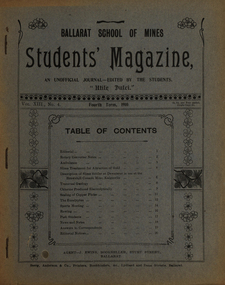
Magazine - Booklet, Ballarat School of Mines, Student Magazine, Fourth Term, 1910, 1910
Table of Contents: Editorial, Rotary converter notes, Ambulance, Slime treatment for attraction of gold, Description of slime settler or dewaterer in use at the Brownhill Consols mine Kalgoorlie, Transvaal geology, Chlorine produced electrolytically, Scaling of copper plates, The eucalyptus, Sports meeting, Rowing, Past students, News and notes, Answers to correspondents, Editorial notices. Images.Magazine of 24 pages. Page 17 lists the whereabout of past Ballarat School of MInes students: J.R. Booth, W.t. Lakeland, Lewis Westcottm Leo M. Seward, Reginald Williamson, Stanley White, Clyde Allan, Charles Lamb, W.E. Eyres, Virgil Tucker, H. Hawkesworth, H.J. Saw, Fred G. Brisnden, C. Stevenson, Fred Treloar, J. Peart, E.M. Weston, Dick Galloway, H.B. Bennetts, G.R. Curry, H. Meadows, Eric Bieske, Cliff Garrard, Phil Brown, Lindsay D. Cameron, Phil Brown,, W.P. Avery, J. Foster, J. Bickett, F.H. Inglis, G. Devenport, t. lennon, h. wilkins, g.h. reid, c. hesselman, E. Fraser, Reginald Callister, F. Bicknell, Leslie Blick, W.T. Sayer, W.F. Hall, O.e. Jaeger, W. Gelard, P.C. Downes, G. Sides, F. Bruce, Frank Bruce.rotary converter, ambulance, slime treatment for attraction of gold, slime settler or dewaterer, brownhill consols mine kalgoorlie, transval geology, chlorine produced electrolytically, scaling of copper plates, eucalyptus, alumni, rollo e. huntley, j.r. booth, w. t. lakeland, lewis westcott, leo m. seward, reginald williamson, stanley white, clyde allan, charles laird, w. e. eyers, virgil tucker, h. hawkesworth, h. j. saw, fred g. brinsden, c. stevenson, fred treloar, j. peart, e. m. weston, dick galloway, h. b. bennetts, g. r. curry, h. meadows, will watson, don cameron, eric bieske, cliff garrard, lindsay d. cameron, phil brown, w. p avery, j. foster, james bickett, f. h. inglis, g. davenport, l. c. courbould, t. lennon, h. wilkins, g. h. reid, c. hesselmann, e. fraser, reginald callister, f. bicknell, leslie blick, w. t. sayer, h. f. hall, o. e. jaeger, w. geldard, p. c. downes, g. sides, f. bruce, e. c. hurdsfield, william baragwanath, r. i. moore, j. l. sampson, h. conran, w. gelard, frederick j. martell, h. cornell, g.c. klug, great fingall consolidated ltd, transvaal geology, eucalyptus gum tree, w.t. lakeland, lewis westcottm leo m. seward, charles lamb, w.e. eyres, h.j. saw, fred g. brisnden, e.m. weston, h.b. bennetts, g.r. curry, w.p. avery, j. bickett, f.h. inglis, g. devenport, g.h. reid, c. hesselman, w.t. sayer, w.f. hall, o.e. jaeger, p.c. downes, frank bruce., mt morgan, kalgoorlie, mt elliott copper mine, ballarat city baths, r.b. young -
 Federation University Historical Collection
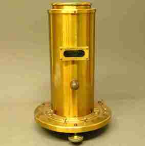
Scientific Instrument, The Cambridge and Paul Instrument Co. Ltd, Galvonometer
A type of instrument used in the 1900s to measure very low currents by sending beams of light to the mirror and reflecting this back onto a wall using the mirror as an amplifier. Small currents in V/A can display a displacement of a few inches on the wall. This instrument has to be balanced, hence the air bubble level and adjustable feet. The meter was scaled in degrees. Galvonometer with all brass body shell removable for initital adjustments. Two observation ports. Base with levelling feet.scientific instrument, galvonometer -
 Clunes Museum
Document
The model was returned to Clunes for the 150th Gold Celebrations and installed at the Clunes Primary School for the duration of the celebrations. It has been returned to Melbourne Museum and is stored in their archive. It was build by Carl Nordstrom, Artisan, who built the model in 1858. It took six months to complete at a cost of 215 Pounds. Built on a scale of 3/8 inch to 1 foot.5 x A4 pages containing the history and description and key to the model of the Port Phillip gold mine provided by the curator of the Melbourne Museum.Nilport phillip mine, 1858, nordstrom, scale model -
 Melbourne Tram Museum
Map, Melbourne cable tram system, 1971?
Map showing the Melbourne cable tram system, with a list of opening and closing dates for the various lines, opened by the Melbourne Tramways Trust. Shows engine houses and car houses (or depots), location names, railways, and a scale. Includes notes on other dates tracks were changed and the Northcote to Clifton Hill line. No marks as to who prepared the map.Yields information about the Melbourne Cable Tram system.Foolscap sheet - Map - Melbourne cable tram system showing tracks, car houses and engine houses.Has a date stamp 22 Apr 1971 in bottom right hand corner.tramways, cable trams, trams, map, melbourne tramways trust, mtt, engine houses, depots, car houses -
 Ballarat Tramway Museum
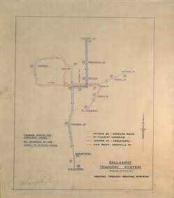
Drawing - Proposed Fares, State Electricity Commission of Victoria (SECV), "Ballaarat Tramway System", 1949
The plan prepared by the SECV shows proposed fares, an increase of 1d on existing fares, and the through routing of tram services. Scale of 40 chains to 1". Alligns with August 1949 Fare By-Law - see item 3111. See also the pdf file "Ballarat Tramway Fares Changes SEC Era", by Warren Doubleday, 03-09-2006.Demonstrates aspects of the way the SEC prepared plans showing tram and ticketing arrangements.Plan titled "Ballaarat Tramway System" - multi-coloured on paper with pencil notations.tramways, ballarat, secv rules, by-laws, tickets, fares -
 Bendigo Military Museum
Document - Australian School of Military Survey - Stereotemplets Precis, School of Military Survey, Balcombe, Unknown
A 6 x page foolscap sized precis, two hole punched and stapled produced by the Australian School of Military Survey discusses using Stereo templet triangulation of aerial photography to establish extra supplementary horizontal control positions. Triangulation using Stereo Templates is a method of achieving the horizontal scale solutions required for photogrammetric mapping procedures.A 6 x page foolscap sized precis, two hole punched and stapled. The precis does not have a protective coverNo "61" on the top LH Cornerroyal australian survey corps, rasvy, fortuna, army survey regiment, army svy regt, asr, sms -
Frankston RSL Sub Branch
Memorabilia - Level, Abney
Square gunsight telescope.An Abney level and clinometer, is an instrument used in surveying which consists of a fixed sighting tube, a movable spirit level that is connected to a pointing arm, and a protractor scale. An internal mirror allows the user to see the bubble in the level while sighting a distant target. It can be used as a hand-held instrument or mounted on a Jacob's staff for more precise measurement, and it is small enough to carry in a coat pocket -
 Bendigo Military Museum
Accessory - PROTRACTOR
Item in the collection re Craig Triffett. Refer Cat No 5997.5 for his service details.1. This is a clear piece of flexible plastic. It has 180 degree arc markings on it. The reference line is at the bottom. Internal rings have numbers marked on them, i.e. 1,2,3,4,5. The outside ring has graduations in 1*. At the bottom are words "Observers Location - Grid", and "Altitude". Scale 1:50000 Army Form B 6716 (1971). 2. Similar to above, but slightly cropped. No explanatory notes.artillery, plotting, protractor, -
 Warrnambool and District Historical Society Inc.
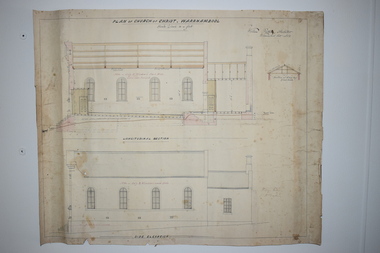
Document, Plan of Church of Christ Warrnambool, 1883
These plans have been drawn up in 1883 by the Warrnambool architect, William Patterson. They show six sections of plans for the erection of a Church of Christ at 12 Spence Street Warrnambool. The mason was William Kellas and the builder was Harold Dawkins. Church of Christ adherents began meeting in Warrnambool in 1875 and bought land in Spence Street in 1877. The church was opened in 1885 with visiting pastors until a resident minister, A. J. Fisher, was appointed in 1915. This church was closed early in the 21st century when a new church, Gateway Church of Christ, was opened in Ragland Parade in Warrnambool. These plans are of great interest as original ones of the Church of Christ In Spence Street Warrnambool. The plans have come from the present-day Warrnambool Church of Christ. The building still exists but is no longer is use as a church. These are two sheets of cream-coloured thick paper with scaled drawings of plan sections of the Church of Christ in Warrnambool. The drawings are in black ink with some sections coloured in. Both pages have a black line margin drawn around the edges. The pages are torn at the edges in several places and the sheets are much stained. The sheets have been reinforced at the back (left side) with thick brown paper.‘Plan of Christ Church Warrnambool’plans church of christ warrnambool, william kellas, harold dawkins warrnambool -
Ringwood and District Historical Society
Map, Government Printer, Melbourne, Ringwood Zone Ordinance Survey Map, 1935
Ordinance survey map glued to cheesecloth, of Ringwood zone - Commonwealth topographical map dated 1.8.35, scale 1:63,360. Information correct up to June 1922. "Ringwood 81" printed on the reverse side.; Envelope and note from donor of item, with return letter of appreciation from Ringwood & District Historical Society dated 20-May-2005. +Additional Keywords: Reid, Don -
Bendigo Historical Society Inc.
Map - CAMPBELL COLLECTION: BENDIGO AND DISTRICT MAPS
Map. Eaglehawk, Parishes of Huntly and Nerring. Scale 20 chains to 1 inch. Total area 6211 acres, Bottom left is Eaglehawk Kerang Railway line. IN PENCIL Euc areas 1974, Laurie C.Raynor Comp 13,14,15. J & T Pierce 1,9,8. The use of sticky tape on joins. Sand heaps from Moon Mine. (number 369 in map cupboard 1)map, bendigo, allotments -
 Bendigo Historical Society Inc.
Document - BILL ASHMAN COLLECTION: CORRESPONDENCE
Notes from C & H Ltd., dated Sept 16, 1937 titled 'Scale Buoys'. Typed on paper with printed letterhead of W. H. Cunningham and Hill, Limited. Notes are a review of results since W. H. Cunningham and Hill, Limited, Wholesale Plumbing and Heating Specialists were handed a patented article, told what it would do, how to apply it, and started out to prove it.sciences, instruments - general, scalebuoy, bill ashman collection - correspondence, w h cunningham and hill limited, dr blackhurst, the scalebuoy company -
Bendigo Historical Society Inc.
Map - CAMPBELL COLLECTION: BENDIGO AND DISTRICT MAPS, 21-8-1972
Map. Shire of Strathfieldsaye Locality Plan. Scale 1 inch=1 mile. Drawn by M.Higgs 21-8-1972, Shire of Huntly, Shire of McIvor, City of Bendigo, Shire of Marong, Shire of Maldon, Shire of Metcalfe, Lake Eppalock, Axedale Township, Strathfieldsaye Township, Melbourne to Bendigo Railway Line, Big Hill Tunnel, Mt.Herbert 1596. (number 398 in map cupboard 1)M.Higgs 21-8-1972map, bendigo, locality plan -
The Ed Muirhead Physics Museum
Diapason normal Tuning Forks. Set of 13 in wooden case
Set of 13 tuning forks tuned to each semitone of the musical scale, based on C4=256 Hertz (A4=435 Hertz); each with spherical brass knob on end; all enclosed in a hinged wooden case. Wooden clamp for forks included in the box. Performance certificate available. 53.1=box 53.2=wooden forks clamp 53.3-53-15 =13 tuning forks.Engraved plaque inside box: International Stimmunt ut 3-517,304v? 1a 3-870v?; C1-258,652 Schwingungen a1-435 Schwingungen. Inscribed on top of box Max Kohl Chemnitz 1/5 Label on side of box:Tuning forks. On each tuning fork size is identified as MK inscribed. -
 Bendigo Historical Society Inc.
Tool - DONEY COLLECTION: BEAM BALANCE SCALES CONTAINED IN TIMBER / GLASS CASE
Beam balance in timber glass case brass and metal beam balance in fair condition crystal pivots, with three leg levelling legs and small string plumb bob to establish initial balancing of the scales balance arms have removable glass concave infills, to measure powders Possible handmade glass case with double glass doors right hand side glass panel cracked -
Bendigo Historical Society Inc.
Document - Application for a Building Permit, 1959
Parry CollectionApplication for a Building Permit for 26 Raglan Street Bendigo 1. Application for Permit to the City of Bendigo by Mr J Parry 3 Yandoit St Bendigo for a cement shed as detailed. The receipt is attached for 10 shillings. 2. Hand Drawn plan of the laundry (Shed) proposed for Mr J Oudijn, scale 1/4 inch = 1 foot, signed and stamped by the City of Bendigo.history, bendigo, j s parry collection, city of bendigo building permit -
 Bendigo Historical Society Inc.
Functional object - Gold weighing scales
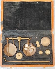
Small gold balance scales in wooden case. The case is inlaid with black velvet cloth with spaces for the balance and weights. There are 2 gm weights, one 5 one 10 gm and a 2 oz in their spaces in the case. There is also one penny weight, a two penny and a 200mg. Completing the set seven differently shaped weights that are too worn out to be identified. Aileen and John Ellison Collection.gold balance, goldfields -
 University of Melbourne, Burnley Campus Archives
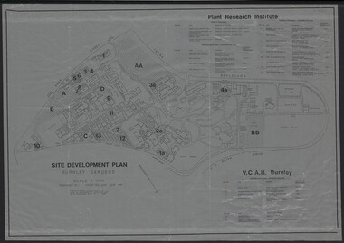
Plan, Site Development Plan - Burnley Gardens, 1988-1989
Used by Honours student, Linda Hipwell in 1999.(1) Site development plan prepared by Steve Mullany June 1989. Scale 1:1000. Photogrammetric plot prepared for the VCAH by Stereometric Services from aerial photography taken 10.07.1988. Plant Research Institute, proposed major buildings 1989-99. Includes legend. (2) 1 tracing paper copy, 3 paper copies, 1 enlargement (some slight variations). plant research, linda hipwell, vcah, students -
Federation University Historical Collection
Map - Map - Geological, Geological Survey of Victoria - Ballarat, 09/1858
Coloured Geological Map of Ballarat, edged with masking tape. The map show alluvial silt, gold drift, geological orders, volcanic, and gold workings. Scale is 8 chains to an inch. WGS 84 Centroid: 37 degrees 33 feet 33 inches south 143 degrees 52 feet 02 inches east W.E. extent: 5km NS extent: 3 kmballarat, ballaarat, geology, goldfield, phillips, j. phillips, mining, alfred selwyn, ferguson and mitchell -
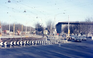 Melbourne Tram Museum
Photograph - Two colour slides - St Kilda Road Trackworks, 1-8-1970
Set of two colour slides showing the intersection of St Kilda Road, City Road and Sturt St. City Road at the start of work to lower City Road under St Kilda Road. The tracks along Sturt St had been diverted by Nolan St (now Southbank Blvd). The photo shows that only one of the tracks had been brought into use, the other still under construction. Photography by Warren Doubleday.Yields information on the start of the works to lower City Road under St Kilda Road 1-8-1970Set of two Anscochrome colour slides, of trackwork to place City Road under St Kilda Road. .1 - SW6 959 on St.-Kilda Rd deviation - shows the Arts Centre and the scale of the deviation. The former tracks into City Road and Sturt St can be seen in the foreground. .2 - SW6 878 - shows the Arts Centre, YMCA building the intersection with City Road and Sturt StHas photographers slide numbers on each slide.st kilda rd, trackworks, city rd, sturt st, sw6 class, tram 959, tram 878, tramways, track -
University of Melbourne, Burnley Campus Archives
Plan, Yates Landscape Details - Mr & Mrs Yates, 1993
Plans by John Patrick Pty. Ltd. (1) Tracing paper plan, Yates Landscape Details DRG No P9235-L3. Drawn by M.P. 12.1.93. (2) Tracing paper plan, Irrigation Plan DRG No P9235-L3. Scale 1:100. Drawn by M.P. 20.8.93. (3) Tracing paper plan, Yates Planting and Layout DRG No 9235-L1. Drawn by M.P. 6.1.93.john patrick pty. ltd., hawthorn, yates, landscape design -
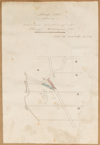
![Map, [Plan for road to give J. Allan access to permanent water at Coimadai] circa 1870s](/media/collectors/5e461d8021ea67224c82f2a1/items/67735190d671e67dd573a84c/item-media/6773533dd671e67dd573cd90/item-fit-380x285.jpg) Bacchus Marsh & District Historical Society
Bacchus Marsh & District Historical SocietyMap, [Plan for road to give J. Allan access to permanent water at Coimadai] circa 1870s
The date of this map or plan is uncertain but it appears to be from the early to mid 1870s. One of the landholders identified on the plan, James Allan of Coimadai died suddenly on the 9th July, 1874 (see Bacchus Marsh Express, 11 July, 1874, page. 3). There are mentions of an Allans Road at Coimadai in the Bacchus Marsh Express between 1887 and 1942.Single page map showing an excision of land belonging to Charles Ross which was selected to construct a road to give another landholder, J. Allan access to permanent water. Scale 1 chain to 1 inch. Part of a set of maps which are pasted into a bound volume containing 76 maps or plans in total. High resolution digital image stored on BMDHS computer network. Plan showing Excisions from Ross's selection and 1 chain road thro' the said selection in Coimadai to give J. Allan access to permanent water. Alistair ?? Shire Eng? 6?/5/7?coimadai victoria maps, coimadai roads and streets -
 Bacchus Marsh & District Historical Society
Map, Rough plan showing proposed deviation of road through McKenzie's Flat
The date of this map or plan is uncertain. McKenzie's Flat is a bushland picnic area on the Lerderderg River in the Lerderderg State Park close to Bacchus Marsh. Single page map showing a proposed deviation of the road near the McKenzie's Flat area close to Bacchus Marsh. The proposed deviation is shaded in pink, The existing road section to be replaced is shaded in blue. No scale is indicated. Part of a set of maps which are pasted into a bound volume containing 76 maps or plans in total. High resolution digital image stored on BMDHS computer network. mckenzies flat bacchus marsh, bacchus marsh roads and streets -
 Bendigo Military Museum
photograph - Royal Australian Survey Corps Aero-triangulation Equipment, 1936 to 1952
Although it’s unknown when these two photos were taken, the South African Pattern Mk IV Slotted Template Machine was in service from 1936 to 1952. The machine was used to cut slots and holes in an acetate film medium. This template was then used to fit several runs of aerial photography to ground control points at a desired scale with a substitution of the templates in the assembly. Radial slots on the templates from central holes representing the photograph’s principal point (centre) were placed over hollow metal studs mounted over control points on the scaled base sheet. The studs represented the intersection of radial lines through common points of detail of overlapping photos. A pricker was used to transfer from the photo-points to the templates. The slotted template methodology was later used as an essential aero-triangulation exercise in advance courses conducted at the School of Military Survey.These three photographs are of a slotted template machine used in aero-triangulation. The first two photographs were printed on photographic paper and are part of the Army Survey Regiment’s Collection. The photographs were scanned at 300 dpi. The third photograph was captured from a collection using a smart phone. .1) and .2) - Photo, black & white, 1936-1952. South African Pattern Mk IV Slotted Template Machine. .3) - Photo, black & white, 1936-1952. WO2 Bob Pratt operating the Slotted Template Machine. .1 and .2 –annotated on back “Slotted Template” .3P - annotated on front “COMPILATION SECTION SLOTTED TEMPLATE MACHINE WO2 BOB PRATT”royal australian survey corps, rasvy, army survey regiment, army svy regt, fortuna, asr, air survey, aerotrig -
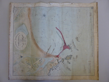 Warrnambool and District Historical Society Inc.
Map, Warrnambool Harbour 1879, 1879
This map shows the plans by eminent harbour engineer, Sir John Coode in 1879. Construction of the breakwater commenced in 1884 and was completed in 1890. Coode first visited Australia in 1872 when he commenced work with the Melbourne Harbour Trust to report on ways to improve Melbourne Port. He is considered one of the most eminent harbour engineers of the 19th century. His original plans for Warrnambool were revised because of cost but then subsequently found to be inadequate and later extended. This was not successful either and the harbour continues to have silting problems to this day. The Warrnambool Breakwater is of historical importance to Victoria and as this map depicts the original plans, it too has great historical significance. It is also significant with its association with Sir John Coode, who was one of the most important port engineers of the 19th century. He worked to improve ports along the Victorian coast including Portland, Geelong, Port Fairy and Lakes Entrance. While this map demonstrates the engineering skills of the era, it also reflects the limitations when natural elements are involved. Its Historical importance also lies in the depiction of items on the map which relate to Warrnambool’s early history. Paper on linen map coloured, and depicting the harbour area of Warrnambool with the proposed breakwater plan in red. It has Victorian Harbours information in oval at top of map. It shows depths of some areas.In oval at top, “Victorian Harbours Warrnambool plan to accompany Sir John Coode report dated 28th Feb 1879. Drawing No 2. Scale 500 feet to 1 inch at bottom centre. Sir John Coode signature in bottom left corner. A 33 A on bottom left reversesir john goode, warrnambool harbour map, warrnambool harbour map 1879, port of warrnambool map 1879 -
 Kiewa Valley Historical Society
Meter Millivolt, after 1950
This milli-volt meter was manufactured after 1950 and used by the SEC Vic (Kiewa Hydro Electricity Scheme) from that date until late 1900's. It was used to measure very small voltages associated with the operation of the various Hydro Generators. The readings were able to be shown by the resistor in use in the current circuit. During this time period, high quality testing instruments were either sourced from Europe or England.This milli-volt meter is very significant to the Kiewa Valley as it was used by those electrical technicians, who were part of the Kiewa Hydro Scheme. An "off spin" from the Scheme was the beginning of an explosion in "human" resources into the Kiewa Valley. This influx of population transformed the region from that of a basically quiet rural region to one which evolved into both industrial and larger residential community. This evolution in the Kiewa Valley created a change, not only in the "physical" landscape(better roads and infrastructure), but also the socio-economic growth within the Valley allowing other "tourist" based industries to expand within the valley and Alpine areas.This millivolts DC meter was used in the 1950's. It is contained in a wooden box and has two coloured (red/black, positive and negative) screw tight knobs which have bake-lite connections. It also has a covered (black tin) view meter marked from zero to 10 millivolts. Underneath this and within a round bake-lite is a small adjustment screw. The top of the box is fastened onto the main structure by six brass screws. The back of the structure is fastened by eight brass screws and there are four small bake-lite rest knobs.On the face of the millivolt compartment , and at the top "TO BE USED WITH DIAL HORIZONTAL TEMP. COEF. +- .08 % PER oC. Underneath the scale "MILLIVOLTS D.C. F.G." (LEAD RESIS. .05 OHMS)" underneath and to the left "MADE IN ENGLAND BY" "EVERSHED & VIGNOLES Ltd" and to the right "No. 857842" underneath Regd. TRADE MARK MEGGERkiewa valley tourism, victorian alps, alternate energy supplies, alpine population growth -
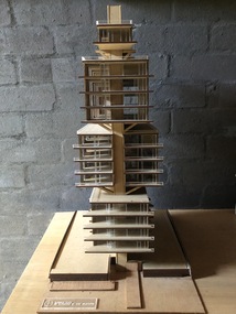 Robin Boyd Foundation
Decorative object - Model of Carnich Towers, 2017
This scale model is an unbuilt Boyd design for a project names Carnich Towers on 60 Clarendon St, East Melbourne. Boyd's perspective drawings from the late 1960's show the influence of Japanese Metabolist thinking in his late work. This model was created for the House of Ideas exhibition, made by a University of Melbourne, Melbourne School of Design, Masters student.Model of Boyd designed Clarendon St Flats, East Melbourne 1969-1971 (unbuilt)robin boyd -
Port Fairy Historical Society Museum and Archives
Photograph
Cowton and Bland were brothers in law and began their partnership in 1847 in an import/export business similar to that of Rutledge and Co., although a lot smaller in scale. Later, the partnership acquired other land on the river front in Gipps Street where they had a wharf and bonded stores . The partnership lasted until 1864. Both men had been sea captains.No other photograph is known to exist of the half round store that is shown here Black and white photograph of bullock team with wagon in Bank Streettransport, rail, road, cowton and bland, import, export