Showing 3069 items matching "scales"
-
 Ballarat Heritage Services
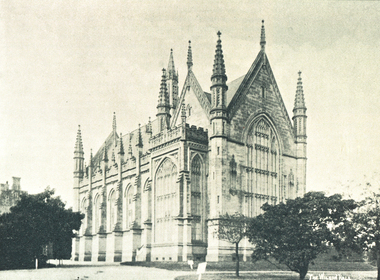
Image, Wilson Hall, Melbourne University
The first Wilson Hall was the gift of Sir Samuel Wilson, who offered the University £30,000 in 1874 for this purpose. Building strated in 1878 and the hall was opened in 1882. It was designed in the Perpendicular Gothic style by Joseph Reed, constructed in stone and built on a very generous scale. In 1952 Wilson Hall was damage by fire, and a new hall was built on the site. The original Wilson Hall was destroyed by fired. Black and white photograph of Wilson Hall, a building in University of Melbourne. It was built in 1890 by Fincham & Hobday. wilson hall, university of melbourne -
 Expression Australia
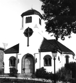
Photograph, Church for the Deaf and Dumb - Jolimont Square, East Melbourne
The Adult Deaf and Dumb Society of Victoria had long wanted its own place of Worship which was realised when this Church built specifically for the Deaf was completed in the Grounds of Jolimont Square, East Melbourne in 1930. This interdenominational chapel was designed by architects Gawler and Drummond for the Society and completed in 1930 in an unusual Romanesque style, although on a much reduced scale from the original design.These photographs are significant as this Church was the first in Australia built speciffically to accommodate the requirement of the Deaf community.16cmHx27cmW and 21cmHx19cmWchurch, jolimont square -
 Tarnagulla History Archive
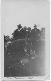
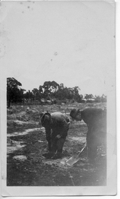
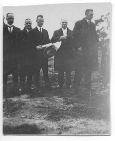
Photograph: Planting ceremony to commence Pine Plantation, Tarnagulla, June 1925
From tarnagulla.org by David Gordon: "The plantation is bounded by King, Gladstone and Welsh Streets and on the east by the drainage channel. It was planted up and opened in June 1925. It is located on the massive sand heap of R.W.Hammond's quartz crushing battery, and the plantation served to enhance the appearance of a large-scale mining precinct which was by 1925 seen as an eyesore from the bygone mining days". Donald Clark Collection. A monochrome photograph of a group of men in suits and hats planting seedlings as part of a planting ceremony to commence the Pine Plantation, Tarnagulla.tarnagulla, trees, mining, pine plantation, the pines, landmarks, children -
 Tarnagulla History Archive
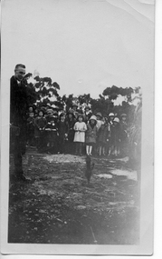
Photograph: Children at planting ceremony to commence Pine Plantation, Tarnagulla, June 1925
From tarnagulla.org by David Gordon: "The plantation is bounded by King, Gladstone and Welsh Streets and on the east by the drainage channel. It was planted up and opened in June 1925. It is located on the massive sand heap of R.W.Hammond's quartz crushing battery, and the plantation served to enhance the appearance of a large-scale mining precinct which was by 1925 seen as an eyesore from the bygone mining days". Donald Clark Collection. A monochrome photograph of a group of children observing a ceremony to commence the Pine Plantation, Tarnagulla.tarnagulla, trees, mining, pine plantation, the pines, landmarks, children -
 Tarnagulla History Archive
Photograph: Planting ceremony to commence Pine Plantation, Tarnagulla, June 1925
From tarnagulla.org by David Gordon: "The plantation is bounded by King, Gladstone and Welsh Streets and on the east by the drainage channel. It was planted up and opened in June 1925. It is located on the massive sand heap of R.W.Hammond's quartz crushing battery, and the plantation served to enhance the appearance of a large-scale mining precinct which was by 1925 seen as an eyesore from the bygone mining days". Donald Clark Collection. A monochrome photograph of two men planting seedlings during a ceremony to commence the Pine Plantation, Tarnagulla.tarnagulla, trees, mining, pine plantation, the pines, landmarks -
 Tarnagulla History Archive
Photograph: Planting ceremony to commence Pine Plantation, Tarnagulla, June 1925
From tarnagulla.org by David Gordon: "The plantation is bounded by King, Gladstone and Welsh Streets and on the east by the drainage channel. It was planted up and opened in June 1925. It is located on the massive sand heap of R.W.Hammond's quartz crushing battery, and the plantation served to enhance the appearance of a large-scale mining precinct which was by 1925 seen as an eyesore from the bygone mining days". Donald Clark Collection. A monochrome photograph of a group of men during a ceremony to commence the Pine Plantation, Tarnagulla. Handwritten inscription on reverse names subjects as (L-R) 'Dad (Foth) on left hand side' and 'Mr [Owen] Jones, Chairman of Forest Commission Vict., Mr Johns District Schools Inspector, Mr McRae Chief Inspector of Forestry of Education Department'.tarnagulla, trees, mining, pine plantation, the pines, landmarks, forestry commission, owen jones, fotheringham -
 Bendigo Military Museum
Administrative record - Army Survey Regiment - PNG JOG After Action Report Cartographic Sqn March 1982, DR Bowen, US Major, OC Carto Sqn, 22 Mar 1982
The Royal Australian Survey Corps produced complete coverage of Papua New Guinea of Joint Operations Graphics (JOG) at 1:250,000 scale. JOG were produced in two versions JOG Ground in metres and JOG Air in feet. This report estimates the amount of manpower required to complete the last 30 x JOG and JOGA as at 22 March 1982 by Cartographic Squadron.A4 typed 4 x page report stapled top LHSroyal australian survey corps, rasvy, fortuna, army survey regiment, army svy regt, asr, png -
 Ithacan Historical Society
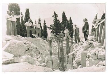
Photograph, Earthquakes: Rebuilding Church of Taxiarchon, Ithaca, 1953
The earthquake in 1953 which reached 7.2 on the Richter Scale caused extensive damage and devastation across the island of Ithaca. Entire villages were totally destroyed and a committee was formed to rebuild the beautiful Church of Taxiarchon which is located on top of Monastery Hill and overlooks the village of Platrithia. It was totally destroyed in the earthquake but is now considered to be one of the most beautiful churches in the Ephtanese group of islands.A black and white photograph of seven men standing around a work site and discussing aspects of a project. A trench with upright steel bars are in the middle of the construction work with soil and rubble heaped on either side. A stamp in Greek is on the back of the photograph. Translation is as follows: Committee rebuilding the Sacred Holy Church of Taxiarchon. Platrithia, Ithaca. earthquakes, church of taxiarchon -
 Bendigo Historical Society Inc.
Document - MISS G ALICE JONES COLLECTION: ACCOUNT
Bendigo Amalgamated Gold Fields Ltd. To Miss G. Alice Jones. Re You V Geo Lakey - County court Summons £59.18.3. Scale C, Sale to Ennor. To Osgood, Land Tax, You V Brauman C. C. S. No. 27 (Special) Scale D £137.1.7, You V Brauman C.C.S. No. 38 (Ordinary), You V Brauman C.C.S. 1924 No. 43 (Special) £137.1.7., Clarence Freeholds-Sale to Bowden, Sea Co. Machinery & Freehold land, Land transferred from New Vic. Catherine Co., re Koch's Pioneer G.M. Co. N.L. transfer of G.M. Lease No 9791 Bendigo, re North Ulster G.M. Co. N.L. transfer of G.M Lease No. 9789 Bendigo. Details of costs and dates varying from June 28, 1923, to March 30, 1925.Also dated 3/6/25 and Pd 30/7/25.the miss g. alice jones collection - account, bendigo amalgamated goldfields ltd, geo lakey, mr stanfield, mr jn smalley, mr thomson, mr crow, mr ennor, osgood, mylon, mrs murdock, constable thomson, brauman, mr miller, melbourne sun, clarence freeholds, j h curnow & son, gazette, sea co, mr legge, mr skews, h m legge & co, new vic catherine co, koch's pioneer g m co nl, north ulster g m co nl, g m lease no 9789 bendigo -
 Bendigo Historical Society Inc.
Photograph - 1853 Bendigo Goldfields Petition, abt 1990-2019
The Red Ribbon Movement of 1853 represented a significant series of events in the history of Bendigo. During that year there was much agitation on the Bendigo gold fields, particularly during July and August of 1853, directed against the payment of what the miners called a tax - a licence fee of thirty shillings ($3) a month for the right to search for gold on what was declared Crown land. They had to pay the licence whether they found gold or not. The miners, or diggers as they were called, also resented the means used by the authorities at the time to collect the gold licence - through so-called 'digger hunts'. The miners were expected to carry their licences with them, and the police, who were often untrained, used harsh methods to check these licences. In Bendigo, the miners took to wearing a red ribbon ‘as a symbol of their protest against the licence. Red was a very common colour in items such as shirts, so was readily available. Shopkeepers too tied red ribbons to their premises as a sign of support for the miners. It should be remembered at that time virtually everyone was a miner. The diggers also had their own banner, designed by William Dexter, a china painter from Devon. This flag showed the pick, shovel and cradle representing labour, the scales representing justice, the Roman bundle of sticks meaning unity and the kangaroo and emu of Australia Many thousands of Bendigo miners signed a petition to La Trobe, the Governor of Victoria, protesting against the licence fee. When the Governor rejected the petition, thousands of diggers marched in peaceful protest. Miners from White Hills, Eaglehawk, Golden Square, Kangaroo Flat as well as from Bendigo Flat, converged on what is now Pall Mall and View Point, surrounding the ~government camp on Camp Hill. The camp had been reinforced with soldiers of the 40 Regiment, as the Government feared bloodshed. The miners then gathered on the hill behind View Point to hear from their leaders - among them George Thomson, Captain Harrison, Captain Brown and W.D.C. Denovan. They resolved to pay a token fee often shillings ($1) for the September licence, whenthey met with Commissioners Panton and Wright on Camp Hill. Although Wright and Panton were sympathetic to the miners, the offer was rejected, but no licence fees were collected for September. Thus a possible bloody conflict was averted by the common sense shown by the miners' leaders and the commissioners. It was a truly democratic protest against arbitrary government and preceded the Eureka Stockade Incident by over a year. Bendigo Historical Society Committee on a Tram, two photos, one of five people standing behind a display cabinet, and the second one a Banner stretched across the tram. On the rear of the photo is "L-R Jim Evans, Terry Davidson, Ron Monro." Second from left is Jim Evans (President) and fourth from the left is Terry Davidson, with extreme right, Ron Munro (Vice President). In the cabinet is the 1853 Bendigo Goldfields Petition (Red Ribbon Rebellion) The society holds the petition in digital form. The diggers had their own banner, designed by William Dexter, a china painter from Devon. This flag showed the pick, shovel and cradle representing labour, the scales representing justice, the Roman bundle of sticks meaning unity and the kangaroo and emu of Australia history, bendigo, tram, 1853 bendigo goldfields petition, red ribbon rebellions -
 Warrnambool RSL Sub Branch
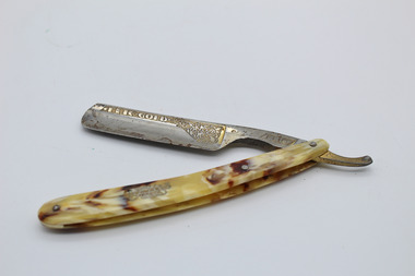
Cut Throat or Straight Razor, Max Voos, Germany, 1930's-1940's
Curved Acrylic (probably) or tortortoise shell handled cutthroat/straight razor with steel blade. Two handle pieces known as 'scales'. Blade hinged through handle with rivet at one end. Thumb notch as part of blade continues past hinge. Two more rivets attach two pieces of handle together; 1st rivet with spacer 4cm from hinge rivet, 2nd rivet at opposite end to hinge. Handle:Gold decorative writing-Flic R with 'REGD' enclosed below on one side approx 9 cm from hinge. 2nd side no inscriptions. Blade: Side 1- FLIC enclosed in rectangular parrallelagram next to hinge. Etched 'gold' decoration and inscription along back edge. Inscription reads 'FLIC GOLD'. Blade: Side 2- Near Hinge- MADE IN GERMANY FROM BEST FLIC SILVER STEEL. Blade: Back edge- Serrations for 5cm from hinge. -
 Bendigo Historical Society Inc.
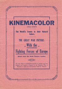
Document - LYDIA CHANCELLOR COLLECTION: 'THE GREAT WAR PICTURE WITH THE FIGHTING FORCES OF EUROPE
A pink programme with black print. On the front are the words ' KINEMACOLOR (urban patents) The World's Events in their Natural Colours. The Great War Picture: With the Fighting Forces of Europe. Direct from the Scale Theatre, London. The Sole Rights for KINEMACOLOR for Australia and New Zealand were secured in England by the Proprietor, Wm. J. Shephard, to whom all communications should be addressed. Mitchell & Casey, General Printers, 25 Tattersall's Lane Melbourne.program, theatre, war, lydia chancellor, collection, w.w. i, event, program, theatre, the great war, war -
 Bendigo Historical Society Inc.
Map - DEVONSHIRE GROUP OF MINES
Small map of Devonshire group of mines, Bendigo. Scale 8 chains to 1 Inch. Issued by M. P. Kelly sharebroker, Bendigo. Showing Hercules and Energetic, Pearl, New Victoria Catherine,, New St Mungo, xtended south devonshire, South Devonshire, United Devonshire,duchess of Edinburgh, Phoenix, South st Mungo, Lady Barkly, St. Mungo, Sadowa, Ellenborough, Williams' United, Catherine Reef United.bendigo, mining, devonshire mine -
Clunes Museum
Book, Percy, John, Percy's Metallurgy - Iron & Steel, 1894
Dowlais is a former Iron/steel making and coal mining town in Wales, United Kingdom.1 Hardcover book light brown embossed cover, gold lettering on spine, 1864, subject matter, the art of extracting metals from their ores and adapting them to various purposes of manufacture. With illustrations, chiefly from original drawings, carefully laid down to scale. .2 Newspaper Article "Dr. Percy on Iron and Steel" published in The Times Tuesday, May 17, 1864 .3 Plan for Dowlais New Mills Gold Lettering on spine: "Percy's Metallurgy Iron & Steel London John Murray Faded Maroon stamp page 2 - Clunes School of Mines No. 24 16 Jun 93metallurgy, mining -
 Ballarat Tramway Museum
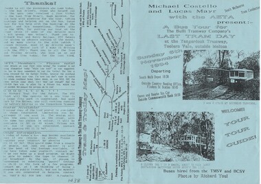
Ephemera - Tour Notes, Michael Costello, "Last tram day at the Yangardook Tramway", Nov. 1994
Single sheet of A4 blue paper, printed on both sides, folded in half to form the notes for a bus tour to the "The Bulli Tramway Company's Last Tram Day at the Yangardook Tramway, Toolern Vale", outside Melton on Sunday 6 November 1994. Gives details of the tramway, the tramcars (large scale models), track, map, details of vehicles, operators and last tram details. Operated in conjunction with the Australian Electric Traction Association.model tramways, closure, toolern vale, yangardook tramway -
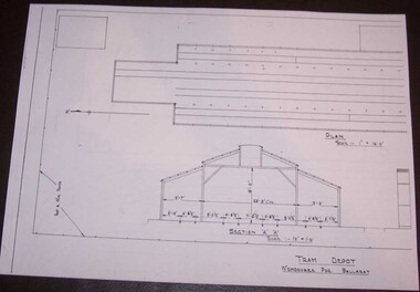 Ballarat Tramway Museum
Document - Photocopy, Alan Bradley, "Tram Depot / Wendouree Pde. Ballarat", 2000
Set of four A3 size photocopies of a drawing BA-T11-8574 held by the Public Records Office Victoria of the Ballarat SEC Tramway Depot, dated c1936. Drawn at a scale of 1" = 16', shows building layout, track layout, overall dimensions, fence types and gates. A front elevation showing the new facade and an internal elevation (drawn at 1/8" = 1'). Drawings copied by Alan Bradley for archives and research.trams, tramways, ballarat, sec, depot, drawings -
 Bendigo Historical Society Inc.
Document - RED RIBBON COLLECTION: DOCUMENT RED RIBBON MOVEMENT 1853
Typed account of the Red Ribbon Movement of 1853. It mentions the resentment of the miners paying thirty shillings a month (whether they found gold or not) for a licence to dig for gold, why they started wearing a red ribbon, their banner with the pick, shovel and cradle representing labour, the scales representing justice, the Roman bundle of sticks meaning unity and the kangaroo and emu of Australia. They had a meeting and due to common sense on both sides a conflict was averted.event, red ribbon movement 1853, william dexter, derby china factory, la trobe, 40th regiment, george thomson, captain harrison, captain brown, dr jones, w d c denovan, commissioner panton, commissioner wright, bendigo art gallery, bendigo trades hall, eureka stockade incident -
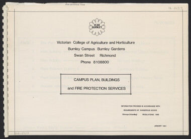 University of Melbourne, Burnley Campus Archives
Plan, Campus Plan, Buildings and Fire Protection Services
site plan, buildings, administration building, plant science laboratories, quad, library, student amenities building, engineering, urban horticulture, nursery -
 Woodend RSL
Map, Afghanistan South Western Oruzgan Helmad and Kandahar Province’s July 2009, September 2009
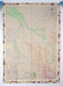
Map was used by Alan Mitchell-Lapin during patrols with Commando Regiment. Alan Mitchell-Lapin is a resident of Woodend.Alan Mitchell-Lappin is a member of the Woodend RSL who served with the Commandos in Afghanistan. Alan was awarded a Commendation for Gallantry for his service in Afghanistan. The map was utilised by Alan during his patrols.Patrol map for South Western Orguzgan Helmand and Kandahar Province’s. Scale 1:200,000. Produced by Australian Government Department of Defence Intelligence and Security. Table top right -Military Legend. Tables middle right - Language distribution, and translation glossary. Table bottom right hand corner - Topograhic Legend. Table centre bottom - Grid magnetic Diagrams. Table top left corner - Tarwin Kowt weather infromation.Produced by the Defence Imagery and Geospatial Organisation, Geospatial Analysis Centre, September 2009. Restricted at time of issue.afghanistan, map, orguzgan, helmand, kandahar, operation slipper, mitchell-lapin, 2009, digo 0098-0910, commando, special forces -
![Map, Plan of Subdivision [Allotments along Lerderderg, George and McFarland Streets]](/media/collectors/5e461d8021ea67224c82f2a1/items/675d7243165f146b8adfc656/item-media/675d72d7165f146b8adfc859/item-fit-380x285.jpg) Bacchus Marsh & District Historical Society
Bacchus Marsh & District Historical SocietyMap, Plan of Subdivision [Allotments along Lerderderg, George and McFarland Streets]
This map shows allotments of land on the northern side of Lerderderg Street from Gisborne Road through to the approximate site of the present day Bacchus Marsh Primary School. There are also allotments shown on the southern side of McFarland Street between George Street and Gisborne Road. Larger allotments of land are shown extending northwards towards Masons Lane. Inscribed at the top of the map are the words, 'Plan of Subdivision of Cr Pors (Crown Portions) 12 & 13 & Allotments 1,2,3,4, Block 3, Parish of Korkuperrimul, County of Bourke'. The date of the map has not been established but the absence of the Bacchus Marsh Primary School on the map suggests it may have been produced prior to 1865 when the primary school was built in Lerderderg Street.Single page map showing house block size land allotments in the Lerderderg, George Street and McFarland Street area of Bacchus Marsh with larger allotments north of this area towards Masons Lane also shown. Scale 150 feet to 1 inch. Part of a set of maps which are pasted into a bound volume containing 76 maps or plans in total. High resolution digital image stored on BMDHS computer network. bacchus marsh victoria maps, lerderderg street land allotments, mcfarland street land allotments -
University of Melbourne, Burnley Campus Archives
Plan, A. Lucy, Burnley Gardens Site Works, 1958
Plan showing layout of Gardens bound by Swan St and the Yarra Boulevard. Buildings shown include Fernery, Silo, Residence, Glasshouses, Manure Bins, Store, Milking Sheds, Admin. Building, Laying Sheds, Breeder Shed, Chicken Run, Potting Shed and Plant Research Lab. Also showing proposed paths and kerbing. Public Works Dept., Chief Engineer's Dept. drawn by A. Lucy. Scale 1 in:40 ftsheds, glasshouses, buildings, a. lucy, burnley gardens -
 Melbourne Athenaeum Archives
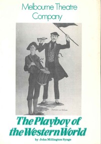
Theatre Program, The Playboy of the Western World (play) by John Millington Synge, performed by the Melbourne Theatre Company at the Athenaeum Theatre commencing 25 July 1978, 1978
John Millington Synge's plays were produced by the Irish National Theatre Society in 1905. Program notes reveal that the first performances "were the focus of some of the bitterest scenes ever witnessed in a theatre. Audience unrest ... grew to full-scale riots, and Yeats claimed that by the end of the week's run 70 police were keeping order inside the theatre, while 500 patrolled the streets outside".Unruly gatherings have been witnessed in the Athenaeum Theatre and Collins Street, such as in 1843, a year after the building was completed: "The first election for the Melbourne seat in 1843 turned into a sectarian battle between a Catholic and a Presbyterian candidate." Supporters of the losing candidate "massed outside the Mechanics Institution where the official declaration of the poll was to occur, and tried to storm the building. The police arrived and did disperse them but only to send them on a rampage throughout the town, ...("Building a Free Australia : Places of Democracy" by John Hirst, 2009)Paper program; coloured cover; 16 p. includes articles about the play and the actors.melbourne theatre company, the playboy of the western world, john millington synge, athenaeum theatre, katy wild, riots -
 Wangaratta RSL Sub Branch
Print - Framed Print
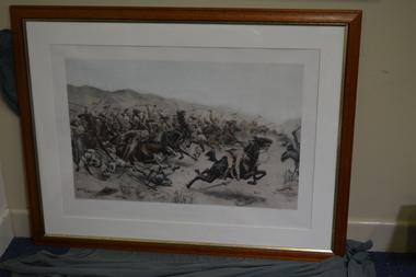
The charge of the 21st Lancers in September 1898 was one of the last full-scale cavalry charges of the British Army. The battle took place 6.4 km. (four miles) outside Omdurman, just north of Khartoum and marked the culmination of Major-General Sir Horatio Herbert (later Field Marshal, 1st Earl) Kitchener's campaign for the re-conquest of the Sudan, the 2nd Sudan War (1896-1898).At the Battle of Omdurman (2 September 1898), an army commanded by the British General Sir Herbert Kitchener defeated the army of Abdullah al-Taashi, the successor to the self-proclaimed Mahdi, Muhammad Ahmad. Kitchener was seeking revenge for the 1885 death of General Gordon. It was a demonstration of the superiority of a highly disciplined army equipped with modern rifles, machine guns, and artillery over a force twice their size armed with older weapons, and marked the success of British efforts to re-conquer the Sudan. Timber framed print depicting mounted soldiers in battleOmdurman Charge of 21st Lancers21st lancers, omdurman, sudan -
 Bendigo Military Museum
Photograph - Photogrammetric Equipment – Army Survey Regiment, Fortuna, Bendigo, c1960s to c1980s
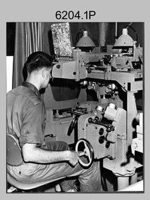
This is a set of eight photographs of technicians operating photogrammetric equipment in Air Survey Squadron, Army Survey Regiment, Fortuna, Bendigo. c1960s to c1980s. The Wild A9 Stereocomparator and Wild B9 stereo plotter were introduced in 1962. The Wild B8 stereo plotter was introduced in 1966. Technicians used the Wild A9 Stereocomparator to accurately measure between pass, tie, and survey control points on aerial photographs. The Wild B9 and B8s were used for plotting topographic detail and contours. These analogue machines were manually controlled by adjusting the control knobs for the orientation of the 3D image. The B9s used a four and a half square, and the B8s used a nine-inch square photo image on a film or glass diapositive which allowed highly accurate extraction of map features. At first, plotting with B8 and B9 stereo plotters was undertaken at the aerial photography scale of 1:80,000 in pencil onto a controlled plotting sheet. Sheets were then inked up and reduced photographically to the 1: 100,000 publication scale for scribe impression production. In the early days topographic detail and contours were plotted with a pencil or ink pen mounted at the far end of the pantograph arm. The plotting procedure was upgraded to direct plotting in ink with photographic reduction to publication scale. In 1975 four B8s were upgraded with tri-axis locaters as part of the Input Sub-system to enable digital extraction to AUTOMAP 1’s topographic database. When AUTOMAP 2 was introduced in 1982 these B8s were upgraded, and additional machines added to expand the Army Survey Regiment’s digital capture capability. This is a set of eight photographs of technicians operating photogrammetric equipment in Air Survey Squadron, Army Survey Regiment, Fortuna, Bendigo. c1960s to c1980s. Black and white and colour photos are on photographic paper and scanned at 300 dpi. .1) - Photo, black & white, c1965. Unidentified technician operating a Wild A9 Stereocomparator. .2) - Photo, black & white, c1965. Unidentified technician operating a Wild B9 stereo plotter. .3) - Photo, black & white, c1967. L to R: Unidentified technician, SPR Ken Jeffery operating a Wild B9 stereo plotter. .4) - Photo, colour, c1974. Unidentified technician, operating a Wild B8 stereo plotter. .5) - Photo, black & white, c1974. Unidentified technician operating a Wild B8 stereo plotter. .6) to .7) - Photo, black & white, c1979. Unidentified technicians operating a Wild B8 stereo plotter. .8) - Photo, black & white, c1985. Unidentified technician in AUTOMAP 2 operating a Wild B8 stereo plotter..1P, .2P, .4P, .5P, .7P – no annotations. .3P – annotated ‘Standing - , Seated SPR Ken Jefferies (sic). .6P – annotated with date ‘1979’ .8P – annotated ‘AUTOMAP 2’royal australian survey corps, rasvy, army survey regiment, army svy regt, fortuna, asr, air survey, photogrammetry -
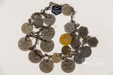 Eltham District Historical Society Inc
Chain with medallions, 1963-1981
More information on this object can be found in Eltham District Historical Society Newsletter No 184 January 2009 and the book "Shoestring" by Joy Jobbins (2007)Chain containing 20 engraved medallions recording names of Etham omelette Joust Champions 1963-1981Engravings on each medallion: Gordon Adams March 1963, Derek Scales March 1964, Bob Gillies Oct 1964, Alan Martin, March 1965, Al Travis March 1968, Graham W, March 1969, Bruce Martin, April 1971, J Jacka, 1978, Rob Robertson 1980 and more. medalions, eltham omelette joust -
 Warrnambool and District Historical Society Inc.
Map, Plans (5) showing Subdivisions of Warrnambool, 1989
These plans have been drawn by Steve Hester for the Warrnambool City Council to illustrate the allotments in Warrnambool concerned with the subdivisions of 1989. The streets have not been named but there is an indication of the area with the identification of known buildings (eg Hospital) and the plan numbers of each allotment is clearly marked. These numbers corresponded to the plan numbers registered in card files and ledgers in the Warrnambool City Council offices. The scale of the plans was 1 to 5000. These plans are of considerable interest because they show Warrnambool street subdivisions of 1989 in illustrative form. They show how information was collated in the late 1980s before the widespread use of computer digital means to describe and store information.These are five hand-drawn sheets showing plans of sub-divisions in Warrnambool streets in 1989 (Warrnambool City Council material). The plans are multi-coloured (crayons) and show allotments with plan numbers. The first plan has much of the material torn off but the location is known to be in the Russells Creek area. Some of the green tape around the edges is missing. Plans two to five are almost intact and are bound with green tape. Plan Two- Industrial Estate of West Warrnambool; Plan Three – Hospital/Merrivale/ Lake Pertobe areas; Plan Four – North Warrnambool, Wollaston/Brierly areas; Plan Five – Flaxman Street area. ‘Subdivision Plan, Reference Guide, Steve Hester, Oct. 1989’. warrnambool street subdivisions, steve hester, history -
Eltham District Historical Society Inc
Document - Folder, Simon Marston
Simon Marston, Eltham veterinarian, went to India as a volunteer for Vet Charity and funded by the Brigitte Bardot Foundation, on the first large-scale dog desexing program; working from three large tents, the team also vaccinated dogs against rabies. Contents Newspaper article: "Vets give rabies the bite in India," Diamond Valley Leader, 20 April 2005, Simon Marston's experience as a volunteer in India.Newspaper clippings, A4 photocopies, etcsimon marston, vet charity, brigitte bardot foundation -
 Bendigo Historical Society Inc.
Newspaper - Lydia Chancellor collection: Bendigo's St. Paul's bells
The 8 diatonic scales bells were cast in London and arrived in Bendigo in 1873, being rung for the first time at Easter 1876. However due to the unsafe nature of the bell tower the bells could only be chimed rather than rung from 1880. In 1963 they were returned to London for recasting and on their return they were installed at a lower level of the bell tower. They were rededicated by the Bishop of Bendigo in 1964Yellow folder titled: Bendigo's St. Paul's bells. Inside many newspaper articles relating to the bells of St. Paul's cathedral in Bendigo.bendigo churches, st. paul's, bells -
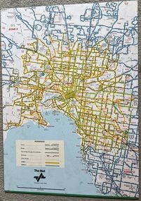 Melbourne Tram Museum
Map, The Met, "Tram and bus Routes showing destination numbers", June 1992
Titled "Tram Routes showing destination numbers". Map dated June 1992 and has been printed with The Met logo. Shows routes with route numbers, names of main destinations, roads, railway stations and rail lines, rivers, scales and Zones. Does not have the CBD insert. Same size as that of item 1099, a 1972 version. Type of map that was placed on the rear of the driver's doors of a W Class tramcar.Demonstrates a The Met produced map used in trramcars.Full colour map or poster printed on paper trimmed from original map and mounted on cardboard.Has some pen marks in the bottom left hand corner.trams, tramways, map, routes, the met -
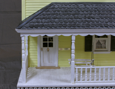 Whitehorse Historical Society Inc.
Mixed media - Doll House Verandah, Yvonne Fitzmaurice, Doll House Veranda, 1974
Hand-made child's doll's house. Built by Mrs Yvonne Fitzmaurice and finished in 1979. This house was built as a 1:12 scale and is a model of a Californian house called Peppercorn farm. House was built by Yvonne and her family and took a period of three years. A lot of the furniture is handmade and the rest is collected from various shops. Catalogued books, manuals, repair kits etc used when building the house.The white painted verandah has a brass plate beside the door with the name Susan Fitzmaurice. In front of the door is a door mat and the veranda has a white hanging seat and a timber flower box with flowers."Susan Fitzmaurice" name on front of building. Date on plaque on top of front wall. Contents: - flower box with flowers, wooden swing, door mat.