Showing 2558 items
matching aerial
-
 Eltham District Historical Society Inc
Photograph - Aerial Photograph, Landata, Research, Vic, Feb. 1956
Centred on present day Thompson Crescent, Research bounded by Maroondah Aqueduct to north, Thompson Crescent and Nyora Road to south, Bells Hill Road to east and Eucalyptus Road to west Historic Aerial Imagery Source: Landata.vic.gov.au Aerial Photo Details: Project No :250 Project : MELBOURNE OUTER SUBURBS PROJECT Run : 19 Frame : 6 Date : 02/1956 Film Type : B/W Camera : EAG9 Flying Height : 10000 Scale : 12000 Film Number : 1176 GDA2020 : 37°42'38"S, 145°11'02"E MGA2020 : 339927, 5824736 (55) Melways : 22 H4 (ed. 42)aerial photo, 1956-02, neil webster collection, bells hill road, eltham, eucalyptus road, maroondah aqueduct, melway 22h4, nyora road, research (vic.), thompson crescent -
 Eltham District Historical Society Inc
Photograph - Aerial Photograph, Landata, Research, Vic, Apr. 1963
Centred on present day Thompson Crescent and Nicholson Close, Research bounded by Maroondah Aqueduct to north, Nyora Road to south, Eltham College to east and Eltham Gateway Hotel to west. Historic Aerial Imagery Source: Landata.vic.gov.au Aerial Photo Details: Project No :486 Project : MELBOURNE (1963) PROJECT Run : 5 Frame : 61 Date : 04/1963 Film Type : B/W Camera : RC8 Flying Height : 5100 Scale : 9600 Film Number : 1805 GDA2020 : 37°42'24"S, 145°10'06"E MGA2020 : 338528, 5825143 (55) Melways : 22 D3 (ed. 42)aerial photo, neil webster collection, eltham, 1963-04, eltham college, eltham gateway hotel and conference centre, maroondah aqueduct, melway 22d3, nicholson close, nyora road, research (vic.), thompson crescent -
 Eltham District Historical Society Inc
Photograph - Aerial Photograph, Landata, Eltham, Vic, Apr. 1963
Centred on present day John Street, Eltham between Main and Bible streets bounded by Elsa Court to north, Main Road Bridge to south, Wattle Grove to east and Bolton Street to west. Historic Aerial Imagery Source: Landata.vic.gov.au Aerial Photo Details: Project No :486 Project : MELBOURNE (1963) PROJECT Run : 6 Frame : 123 Date : 04/1963 Film Type : B/W Camera : RC8 Flying Height : 5100 Scale : 9600 Film Number : 1805 GDA2020 : 37°43'12"S, 145°08'54"E MGA2020 : 336800, 5823623 (55) Melways : 21 J6 (ed. 42)aerial photo, neil webster collection, 1963-04, bolton steet, elsa court, eltham, john street, main road, main road bridge, melway 21j6, wattle grove -
 Eltham District Historical Society Inc
Photograph - Aerial Photograph, Landata, Eltham, Vic, Apr. 1963
Centred on present day Eltham Ridge, Bolton Street, Eltham bounded by Elsa Court to north, Main Road to south, Bible Street to east and Reichelt Avenue and Rattray Road to west. Historic Aerial Imagery Source: Landata.vic.gov.au Aerial Photo Details: Project No :486 Project : MELBOURNE (1963) PROJECT Run : 6 Frame : 124 Date : 04/1963 Film Type : B/W Camera : RC8 Flying Height : 5100 Scale : 9600 Film Number : 1805 GDA2020 : 37°43'12"S, 145°08'16"E MGA2020 : 335876, 5823604 (55) Melways : 21 G6 (ed. 42)aerial photo, neil webster collection, 1963-04, bible street, bolton street, eltham, eltham ridge, main road, montmorency, rattray road, reichelt avenue -
 Eltham District Historical Society Inc
Photograph - Aerial Photograph, Landata, Eltham, Vic, Apr. 1963
Centred on present day Griffith Park Road, Eltham bounded by Mount Pleasant Road to north, Yarra River and Templestowe to south, Main Road at Reynolds Road to east and Falkiner Street to west. Historic Aerial Imagery Source: Landata.vic.gov.au Aerial Photo Details: Project No :486 Project : MELBOURNE (1963) PROJECT Run : 7 Frame : 233 Date : 04/1963 Film Type : B/W Camera : RC8 Flying Height : 5100 Scale : 9600 Film Number : 1805 GDA2020 : 37°44'04"S, 145°09'10"E MGA2020 : 337237, 5822053 (55) Melways : 22 A10 (ed. 42)aerial photo, neil webster collection, 1963-04, eltham, falkiner street, griffith park road, melway 22a10, mount pleasant road, reynolds road, templestowe, yarra river -
 Eltham District Historical Society Inc
Photograph - Aerial Photograph, Landata, Eltham, Vic, Apr. 1972
Centred on present day Zig Zag Road near Coolabah Drive, Eltham bounded by Allendale Road to north, Park West Road to south, Parsons Road to east and Banks Road to west. Historic Aerial Imagery Source: Landata.vic.gov.au Aerial Photo Details: Project No :985 Project : MELBOURNE 1972 Run : 26 Frame : 191 Date : 04/1972 Film Type : B/W Camera : RC10 Flying Height : 5700 Scale : 9600 Film Number : 2636 GDA2020 : 37°41'56"S, 145°09'26"E MGA2020 : 337533, 5826000 (55) Melways : 22 A1 (ed. 42)aerial photo, neil webster collection, 1972-04, allendale road, eltham, eltham north, zig zag road, banks road, coolabah drive, melway 22a1, park west road, parsons road -
 Eltham District Historical Society Inc
Photograph - Aerial Photograph, Landata, Eltham, Vic, Apr. 1972
Centred on present day Parsons Road, Eltham bounded by Allendale Road to north, Frank Street to south, Research Shops and Raglan Road to east and Zig Zag Road to west. Historic Aerial Imagery Source: Landata.vic.gov.au Aerial Photo Details: Project No :985 Project : MELBOURNE 1972 Run : 26 Frame : 192 Date : 04/1972 Film Type : B/W Camera : RC10 Flying Height : 5700 Scale : 9600 Film Number : 2636 GDA2020 : 37°42'00"S, 145°09'59"E MGA2020 : 338360, 5825897 (55) Melways : 22 D1 (ed. 42)aerial photo, neil webster collection, 1972-04, allendale road, eltham, zig zag road, frank street, melway 22d1, parsons road, raglan road, research (vic.), research shops, eltham barrel -
 Eltham District Historical Society Inc
Photograph - Aerial Photograph, Landata, Eltham, Vic, Apr. 1972
Centred on present day Woodridge Estate, Eltham bounded by Park Road to north, Mount Pleasant Road to south, Stokes Orchard Estate to east and Eltham Railway Station to west. Historic Aerial Imagery Source: Landata.vic.gov.au Aerial Photo Details: Project No :985 Project : MELBOURNE 1972 Run : 27 Frame : 46 Date : 04/1972 Film Type : B/W Camera : RC10 Flying Height : 5700 Scale : 9600 Film Number : 2636 GDA2020 : 37°42'49"S, 145°09'46"E MGA2020 : 338053, 5824365 (55) Melways : 22 C5 (ed. 42)aerial photo, neil webster collection, 1972-04, eltham, eltham railway station, melway 22c5, mount pleasant road, park road, stokes orchard estate, woodridge estate -
 Eltham District Historical Society Inc
Photograph - Aerial Photograph, Landata, Eltham, Vic, Apr. 1972
Centred on present day Main Road at Pryor Street, Eltham bounded by Park West Road to north, Napoleon Street to south, Woodridge Estate to east and Ryans Road to west. Historic Aerial Imagery Source: Landata.vic.gov.au Aerial Photo Details: Project No :985 Project : MELBOURNE 1972 Run : 27 Frame : 47 Date : 04/1972 Film Type : B/W Camera : RC10 Flying Height : 5700 Scale : 9600 Film Number : 2636 GDA2020 : 37°42'45"S, 145°09'12"E MGA2020 : 337223, 5824470 (55) Melways : 22 A4 (ed. 42)aerial photo, neil webster collection, 1972-04, eltham, eltham railway station, woodridge estate, eltham shops, main road, melway 22a4, napoleon street, park west road, pryor street, ryans road -
 Eltham District Historical Society Inc
Photograph - Aerial Photograph, Landata, Eltham, Vic, Apr. 1972
Centred on present day Dalton Street at Mount Pleasant Road, Eltham bounded by Arthur Street to north, Yarra River and Kent Hughes Road to south, Eucalyptus Road to east and Susan Street to west. Historic Aerial Imagery Source: Landata.vic.gov.au Aerial Photo Details: Project No :985 Project : MELBOURNE 1972 Run : 28 Frame : 208 Date : 04/1972 Film Type : B/W Camera : RC10 Flying Height : 5700 Scale : 9600 Film Number : 2635 GDA2020 : 37°43'29"S, 145°08'54"E MGA2020 : 336816, 5823118 (55) Melways : 21 J8 (ed. 42)aerial photo, neil webster collection, 1972-04, eltham, arthur street, dalton street, eucalyptus road, kent hughes road, melway 21j8, mount pleasant road, susan street, yarra river -
 City of Kingston
Photograph - Colour, 29 January 1993
Bonbeach is a small beachside suburb located between Chelsea and Carrum. The station was opened in 1926 and was the last to be established in the group from Aspendale to Carrum. Urban growth began after World War II. State primary and high schools were opened in 1958 on land in Breeze Street that was once occupied by The Australian Glass Manufacturers. Immediately east of the school sites is the Patterson River Golf Club. The Bonbeach sports reserve has five ovals and is home to the Bonbeach football and baseball clubs. The suburb borders the Edithvale-Seaford Wetlands which is the remnant site of the Carrum Carrum swamp, once the home of the Bunurong people.Bonbeach was originally a seaside destination for holidaymakers and the housing comprised of holiday homes and gradually more permanent residents. It was not until 1926 that Bonbeach had its own railway station. From 1906 until the late 1940s sand was quarried on the east side of the railway line and used in the manufacture of glass. The Australian Glass Manufacturers sold this land in residential blocks and Bonbeach's permanent population spread from the coastal strip across to the other side of the railway line. Laminated colour aerial photograph of the suburb of Bonbeach and also the southern section of neighbouring Chelsea within the City of Kingston. The extent of this 1993 aerial image includes: Top left - Maury Road at the south end of the Chelsea shopping Centre; Top right - Scotch Parade Chelsea Bottom left - Monica Avenue in Bonbeach; Bottom right - Patterson River Golf Club. Landmarks include St Joseph's Church and Primary School, Chelsea Primary School, Bonbeach Station, Bonbeach Fotball Club sports playing fields and Bonbeach Life Saving Club. The Edithvale Wetlands is featured prominently to the right-hand side of the image. Black typed writing on white adhesive label: No. 6662 Black typed writing on white adhesive label: 26E/6662, 29/1/93, 4.25 pm Black typed writing on white adhesive label: 29-1-93 Black typed writing on white adhesive label: P000109 Circular yellow adhesive sticker bonbeach, chelsea -
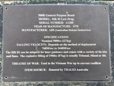 Bendigo Military Museum
Weapon - BOMB, AERIAL 500 LB, Australian Defence Industries, C.1970
This item is situated in the Gardens of the Bendigo District RSL Sub Branch Inc Havilah Road. Refer photo .1) for the details re manufacture and history/use..1) Plaque on metal stand, black with white text re details of a 500 Lb Bomb. .2) Weapon, 500 lb General Purpose Aerial Bomb, cylindrical shape, nose cone tapers to a point, tail tapers to near point with 4 fins attached. bdrslinc, smirsl, brsl, 500, bomb -
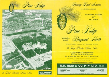 Ringwood and District Historical Society
Flyer, Land Auction Sale Brochure, Pine Lodge, Ringwood North, Victoria - 1977
Refer also to Reg. No. 5172 for Pine Lodge Land Auction 3rd release, 1978.Yellow double-sided real estate auction notice with green print showing aerial photograph and map of subdivision layout and summary of local features and services for Pine Lodge, Kalinda Road, Ringwood North. Auction date, Saturday, 4th June, 1977, at 2:30pm.Subdivision plan includes Parkgate Drive, Wood-Church Close, and Pensby Court. (Agent) N.R. Reid & Co. Pty. Ltd., Safeway Centre, Boronia Road, Boronia (Phone) 762 1022, 450 Little Collins Street, Melbourne (Phone) 67 1746, and 207 Stud Road, Wantirna South (Phone) 231 2277. -
Southern Sherbrooke Historical Society Inc.
Map, Dept of land s & Survey, Dandenong Ranges Area Sheet 28, Jan-56
Owned by David Walker, previously of Menzies Creek. Given by him to Rex Breen in 2001 for donation to society.Aerial survey map of parts of Gembrook, Monbulk and Naree Worran parishes (Victoria). Scale: 10 chains to 1 inch, contour interval 20 feet. Shows Menzies Creek and parts of Kallista, Clematis, Selby and Belgrave South. Ringwood D2C or 849D2C, Zone 7"16563" in pen on top left corner of reverse. -
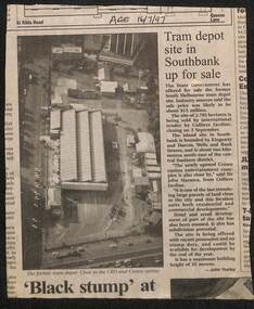 Melbourne Tram Museum
Newspaper, The Age, "Tram depot site in Southbank up for sale", 16/07/1997 12:00:00 AM
Newspaper clipping, The Age 16/7/1997, titled "Tram depot site in Southbank up for sale", advising the depot site would be sold by Colliers Jardine. Gives details of the site and has an aerial photo. Quotes John Marasco of Colliers. Written by John Hurley.trams, tramways, sale of land, south melbourne depot, southbank depot, tram depot -
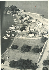 Lakes Entrance Historical Society
Photograph, Shaving Point Metung Victoria, 1960
Black and white aerial photograph of village of Metung showing hotel and main wharf and private jetties on Bay side, and beach on Lake King side with road to Shaving Point Metung Victoria. Also a black and white photograph of Village Store Metung Victoria 1930 cwaterways -
 Port Melbourne Historical & Preservation Society
Photograph - Aerial view Centenary Bridge, Swallow St, forecourt Station Pier, Railyards
While there are many vehicles and pedestrians on the bridge and on Swallow Street, there is no action on the pier. Circa 1940Aerial view of Centenary Bridge, Swallow Street and Railyards. Circa 1940. Taken at same time as catalogue 5001 but with less view of Station Pier. An event of some sort had been on as there are many pedestrians and vehicles on Centenary Bridge and Swallow St, but it appears the pier was not the focus.piers and wharves, railyards, swallow street -
 Greensborough Historical Society
Folder, Banyule City Council, Main Street Greensborough, 2007-2011
Folder of coloured photographs of Main Street Greensborough, plus one aerial photograph of the area bounded by Grimshaw, Flintoff, Para and Main Streets and one of Grimshaw Street between Henry and Main Streets. Greensborough Shopping Centre prior to the construction of WatermarcGreen plastic folder of coloured photographic prints of Main Street Greensborough.main street greensborough, banyule city council, watermarc -
 Magnet Galleries Melbourne Inc
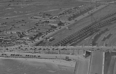
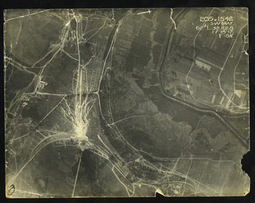
exlosion in aerial photo, dargo-104.tif
The First World War saw the widespread adoption of aerial photography to record vital tactical information, such as troop movements, gun emplacements and topography. Here an exploding ammunition dump near Bray in France is sending fireworks several thousand feet into the sky.In the top right of the frame there are some coordinates.bray, france, aerial view, ww1, world war 1, 1917 -
 Greensborough Historical Society
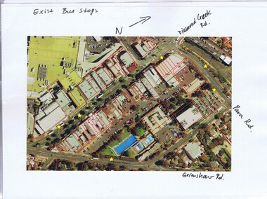
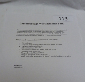
Work on paper - Folder of Documents, Ian Bryant, War Memorial Park Greensborough, 2011_
Folder of documents about War Memorial Park Greensborough including aerial photographs and title documents (collected by Ian Bryant) and other information on War Memorial Park bordered by McDowell Street, Ester Street, Henry Street and Vermont Parade Greensborough.Folder of documents - 2 ring binder and A4 printed pages in plastic pockets.greensborough war memorial park, public space, war memorials, ian bryant, parks banyule -
 Eltham District Historical Society Inc
Photograph - Aerial Photograph, Landata, Eltham, Vic, Jan. 1951
Centred on Allison Crecent Reserve, Sherbrook Road and Scenic Crescent, Eltham bounded by Allendale Road to north, Dudley Street to south, Zig Zag Road to east and St Helena Road to west. Historic Aerial Imagery Source: Landata.vic.gov.au Aerial Photo Details: Project No :65 Project : MELBOURNE AND METROPOLITAN PROJECT NO. 2 Run : 7 Frame : 10 Date : 01/1951 Film Type : B/W Camera : EAG9 Flying Height : 12200 Scale : 12000 Film Number : 1419 GDA2020 : 37°42'14"S, 145°08'36"E MGA2020 : 336339, 5825416 (55) Melways : 21 H2 (ed. 42)Historical aerial photos and photo maps provide viusal evidence of the chronology of changes to the built landscape of the district and assist in dating other imagesaerial photo, 1951-01, eltham, neil webster collection, allendale road, allison crecent reserve, dudley street, melway 21h2, scenic crescent, sherbrook road, st helena road, zig zag road -
 Eltham District Historical Society Inc
Photograph - Aerial Photograph, Landata, Montmorency, Feb. 1956
Centred on present day Grand Boulevard and Olympic Way, Montmorency bounded by Diamond Street to north, Old Eltham Road and Eltham Lower Park to south, Bible Street to east and Para Road to west. Historic Aerial Imagery Source: Landata.vic.gov.au Aerial Photo Details: Project No :250 Project : MELBOURNE OUTER SUBURBS PROJECT Run : 17 Frame : 115 Date : 02/1956 Film Type : B/W Camera : EAG9 Flying Height : 10000 Scale : 12000 Film Number : 1176 GDA2020 : 37°43'24"S, 145°07'55"E MGA2020 : 335375, 5823236 (55) Melways : 21 F7 (ed. 42)aerial photo, 1956-02, neil webster collection, eltham, main road, montmorency, bible street, diamond street, eltham lower park, grand boulevard, melway 21f7, old eltham road, olympic way, para road -
 Eltham District Historical Society Inc
Photograph - Aerial Photograph, Landata, Eltham, Feb. 1956
Centred on present day Mount Plaeasant Road near Dalton Street, Eltham bounded by Luck Street to north, Eltham Lower Park to south, Reynolds Road to east and Central Park to west Historic Aerial Imagery Source: Landata.vic.gov.au Aerial Photo Details: Project No :250 Project : MELBOURNE OUTER SUBURBS PROJECT Run : 18 Frame : 93 Date : 02/1956 Film Type : B/W Camera : EAG9 Flying Height : 10000 Scale : 12000 Film Number : 1176 GDA2020 : 37°43'02"S, 145°09'38"E MGA2020 : 337871, 5823961 (55) Melways : 22 B6 (ed. 42)aerial photo, 1956-02, neil webster collection, eltham, central park, eltham lower park, luck street, melway 22b6, nyora road, reynolds road, dalton street, mount pleasant road -
 Eltham District Historical Society Inc
Photograph - Aerial Photograph, Landata, Eltham, Vic, Feb. 1956
Centred on present day Parsons Avenue at Leane Drive near the Maroondah Aqueduct, Eltham bounded by Lorimer Road to north, Thompson Crescent and Norman Road to south, Bells Hill Road to east and Parsons Road to west Historic Aerial Imagery Source: Landata.vic.gov.au Aerial Photo Details: Project No :250 Project : MELBOURNE OUTER SUBURBS PROJECT Run : 19 Frame : 5 Date : 02/1956 Film Type : B/W Camera : EAG9 Flying Height : 10000 Scale : 12000 Film Number : 1176 GDA2020 : 37°42'04"S, 145°11'09"E MGA2020 : 340064, 5825786 (55) Melways : 22 H1 (ed. 42)aerial photo, 1956-02, neil webster collection, allendale road, bells hill road, eltham, leane drive, lorimer road, maroondah aqueduct, melway 22h1, norman road, parsons road, research (vic.), thompson crescent -
 Eltham District Historical Society Inc
Photograph - Aerial Photograph, Landata, Eltham, Vic, Apr. 1963
Centred on present day Zig Zag Road and Main Road, Eltham bounded by Maroondah Aqueduct to north, Thompson Crescent and Arthur Street to south, Parsons Road to east and Glen Park Road and Banks Road to west. Historic Aerial Imagery Source: Landata.vic.gov.au Aerial Photo Details: Project No :486 Project : MELBOURNE (1963) PROJECT Run : 5 Frame : 59 Date : 04/1963 Film Type : B/W Camera : RC8 Flying Height : 5100 Scale : 9600 Film Number : 1805 GDA2020 : 37°42'24"S, 145°08'52"E MGA2020 : 336716, 5825114 (55) Melways : 21 J3 (ed. 42)aerial photo, neil webster collection, eltham, 1963-04, arthur street, banks road, glen park road, maroondah aqueduct, melway 21j3, parsons road -
 Eltham District Historical Society Inc
Photograph - Aerial Photograph, Landata, Eltham, Vic, Apr. 1963
Centred on present day Floriston Grove, Eltham bounded by Maroondah Aqueduct to north, Thompson Crescent and Diosma Road to south, Research Shops to east and Glen Park Road and Park West Road to west. Historic Aerial Imagery Source: Landata.vic.gov.au Aerial Photo Details: Project No :486 Project : MELBOURNE (1963) PROJECT Run : 5 Frame : 60 Date : 04/1963 Film Type : B/W Camera : RC8 Flying Height : 5100 Scale : 9600 Film Number : 1805 GDA2020 : 37°42'24"S, 145°09'29"E MGA2020 : 337622, 5825128 (55) Melways : 22 B3 (ed. 42)aerial photo, neil webster collection, eltham, 1963-04, diosma road, floriston grove, maroondah aqueduct, melway 22b3, park west road, research (vic.), research shops -
 Eltham District Historical Society Inc
Photograph - Aerial Photograph, Landata, Lower Plenty, Vic, Apr. 1963
Centred on present day Old Eltham Road near Araluen Centre, Lower Plenty bounded by Cromwell Street to north, Yarra River to south, Main Road at Mount Pleasant Road to east and Panorama Avenue to west. Historic Aerial Imagery Source: Landata.vic.gov.au Aerial Photo Details: Project No :486 Project : MELBOURNE (1963) PROJECT Run : 7 Frame : 231 Date : 04/1963 Film Type : B/W Camera : RC8 Flying Height : 5100 Scale : 9600 Film Number : 1805 GDA2020 : 37°44'03"S, 145°07'56"E MGA2020 : 335420, 5822027 (55) Melways : 21 F10 (ed. 42)aerial photo, neil webster collection, 1963-04, araluen, cromwell street, eltham, lower plenty, main road, melway 21f10, mount pleasant road, old eltham road, panorama avenue, yarra river -
 Eltham District Historical Society Inc
Photograph - Aerial Photograph, Landata, Eltham, Vic, Apr. 1963
Centred on present day Eltham Lower Park bounded by Brougham Street to north, Yarra River and Fitzsimons Lane Bridge to south, Main Road at Kent Hughes Road to east and Bolton Street to west. Historic Aerial Imagery Source: Landata.vic.gov.au Aerial Photo Details: Project No :486 Project : MELBOURNE (1963) PROJECT Run : 7 Frame : 232 Date : 04/1963 Film Type : B/W Camera : RC8 Flying Height : 5100 Scale : 9600 Film Number : 1805 GDA2020 : 37°44'03"S, 145°08'33"E MGA2020 : 336329, 5822040 (55) Melways : 21 H10 (ed. 42)aerial photo, neil webster collection, 1963-04, bolton steet, brougham steet, eltham, eltham lower park, fitzsimons lane bridge, kent hughes road, melway 21h10, yarra river -
 Eltham District Historical Society Inc
Photograph - Aerial Photograph, Landata, Eltham North, Vic, Apr. 1972
Centred on present day Eltham North reserve near Eltham North Primary School, Eltham North bounded by Allendale Road to north, Bellevue Road to south, Zig Zag Road and Beard Street to east and Ryans Road to west. Historic Aerial Imagery Source: Landata.vic.gov.au Aerial Photo Details: Project No :985 Project : MELBOURNE 1972 Run : 26 Frame : 190 Date : 04/1972 Film Type : B/W Camera : RC10 Flying Height : 5700 Scale : 9600 Film Number : 2636 GDA2020 : 37°41'52"S, 145°08'52"E MGA2020 : 336705, 5826102 (55) Melways : 11 J12 (ed. 42)aerial photo, neil webster collection, 1972-04, allendale road, beard street, bellevue road, eltham, eltham north, eltham north reserve, melway 11j12, ryans road, zig zag road, eltham north primary school -
 Eltham District Historical Society Inc
Photograph - Aerial Photograph, Landata, Research, Vic, Apr. 1972
Centred on present day Main Road, Research near Maroondah Aqueduct and Eltham College bounded by Allendale Road to north, Research-Warrandyte Road to south, Swipers Gully Training Restaurant to east and Reynolds Road to west. Historic Aerial Imagery Source: Landata.vic.gov.au Aerial Photo Details: Project No :985 Project : MELBOURNE 1972 Run : 26 Frame : 194 Date : 04/1972 Film Type : B/W Camera : RC10 Flying Height : 5700 Scale : 9600 Film Number : 2636 GDA2020 : 37°42'07"S, 145°11'07"E MGA2020 : 340015, 5825692 (55) Melways : 22 H1 (ed. 42)aerial photo, neil webster collection, 1972-04, allendale road, eltham college, main road, maroondah aqueduct, melway 22h1, research (vic.), research-warrandyte road, reynolds road, swiper's gully