Showing 2047 items matching "piers"
-
 Glenelg Shire Council Cultural Collection
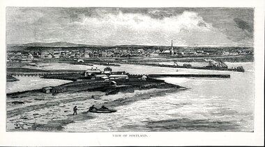
Artwork, other - Illustration Portland Barton's Beach, n.d
Illustration. Taken and cut from a book. Black and White rectangle image on off white paper. Portland from Barton's Beach, looking north west. Panoramic view in background of Portland's town with original buildings. All Saints Catholic Church with spire recognisable. Pier in the Middle right with various structures and a docked ship with sails. Bottom left 3 people launching two canoes at the beach. Wattle Creek or Salt Creek with bridge structure on the middle left. Front: 'VIEW OF PORTLAND' - printed, bottom frame. Signature 2cm in from the left corner of the frame 'CALVERT. SS'portland, bartons beach, portland bay -
 Port Melbourne Historical & Preservation Society
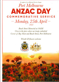
Programme, Port Melbourne Anzac Day Commemorative Service 2022, 25 Apr 2022
Distributed during the Beach Street, Port Melbourne service Monday 25 Feb 2022.The four page program has a white cover with the image of a field of poppies across the lower section. It was produced in support of our Returned Services League for the Port Melbourne Anzac Day Commemorative Service held on Monday 25 April 2022 at 10.00 am at the Beach Street Memorial.the information "Close to the piers where our troops embarked Corner of Bay & Beach Street, Port Melbourne. Wreath & flowers welcome" is inscribed on the cover while inside has the Order of Service.anzac day, rsl, returned services league -
 Orbost & District Historical Society
black and white photographs, 1934
These photographs were taken just after the McKillop's Bridge was completed after the flood damage. The current McKillop’s Bridge was built by the Country Roads Board in two stages between 1931-36, during which its height was raised after the original bridge superstructure was washed away in record floods of January 1934, prior to its original official opening. In its reconstructed form the original concrete abutments were turned into additional piers and the welded-steel trusses were cantilevered back over them to meet the new higher road approaches. It is sited at McKillops Crossing, named after pioneer overlanding squatter George McKillop who crossed here in 1835. This was a stock crossing place for almost a century before the bridge was constructed. (info. from Victoria Heritage Register)This is a pictorial record of the history of McKillop's Bridge, in itself of historical significance for its association with Victoria's long and important pastoral history, its technicl significance and aesthetic significance.Three black / white photographs. 3133.1 shows the approach to a washed away bridge. 3133.2 is of a bridge over a river with men clearing debris. 3133.3 is a close-up showing the wreckage of the bridge.mckillop's-bridge snowy-river flood-damage-1934 -
 Port Melbourne Historical & Preservation Society
Container - Royal Humane Society certificate holder, 1889 - 1900
Archibald Ernest SWANNIE was awarded two Royal Humane Society bronze medals (case numbers 1817 and 1880) for rescuing two people from drowning on separate occasions, at Railway Pier, Port Melbourne and at Queensbridge (city). Medal awarded to Archibald Ernest Swannie 13.02.1899 . Bar awarded 25.12.1899. The RHS awards a bronze medal for the first award and then adds a bronze bar to that medal as the second award. The first saving occurred on 13 February 1899 and the award ceremony occurred on 19 April 1899. The second saving occurred on 25 December 1899 and the ceremony was 20 June 1900 (case number 1880 Cat Nos .03.and .05 relate to this case) A E SWANNIE lived in Gladstone Place Montague ; played 46 games with PMFC and was a member of the 1901 Premiership team.Black leather certificate holders (rolled) with gold lettering "RHS of Australasia"awards and presentations, piers and wharves - railway pier, sport - australian rules football, royal humane society of australasia, archibald ernest swannie -
Port Melbourne Historical & Preservation Society
Award - Humane Society Bronze Medal, 1889 - 1900
Archibald Ernest SWANNIE was awarded two Royal Historical Society bronze medals (case numbers 1817 and 1880) for rescuing two people from drowning on separate occasions, at Railway Pier, Port Melbourne and at Queensbridge (city). Medal awarded to Archibald Ernest Swannie 13.02.1899 . Bar awarded 25.12.1899. The RHS awards a bronze medal for the first award and then adds a bronze bar to that medal as the second award. The first saving occurred on 13 February 1899 and the award ceremony occurred on 19 April 1899. The second saving occurred on 25 December 1899 and the ceremony was 20 June 1900 (case number 1880 Cat Nos .03.and .05 relate to this case) A E SWANNIE lived in Gladstone Place Montague ; played 46 games with PMFC and was a member of the 1901 Premiership team.Royal Humane Society Bronze medal and bar attached to navy corded ribbon and bronze pinawards and presentations, piers and wharves - railway pier, sport - australian rules football, royal humane society of australasia, archibald ernest swannie -
Port Melbourne Historical & Preservation Society
Container - Navy leather case, 1889 - 1900
Archibald Ernest SWANNIE was awarded two Royal Historical Society bronze medals (case numbers 1817 and 1880) for rescuing two people from drowning on separate occasions, at Railway Pier, Port Melbourne and at Queensbridge (city). Medal awarded to Archibald Ernest Swannie 13.02.1899 . Bar awarded 25.12.1899. The RHS awards a bronze medal for the first award and then adds a bronze bar to that medal as the second award. The first saving occurred on 13 February 1899 and the award ceremony occurred on 19 April 1899. The second saving occurred on 25 December 1899 and the ceremony was 20 June 1900 (case number 1880 Cat Nos .03.and .05 relate to this case) A E SWANNIE lived in Gladstone Place Montague ; played 46 games with PMFC and was a member of the 1901 Premiership team.Navy leather case with navy silk padded lining, containing Medal (.01), gold lettering on lidawards and presentations, piers and wharves - railway pier, sport - australian rules football, royal humane society of australasia, archibald ernest swannie -
Port Melbourne Historical & Preservation Society
Certificate - Royal Humane Society, 1889 - 1900
Archibald Ernest SWANNIE was awarded two Royal Humane Society bronze medals (case numbers 1817 and 1880) for rescuing two people from drowning on separate occasions, at Railway Pier, Port Melbourne and at Queensbridge (city). Medal awarded to Archibald Ernest Swannie 13.02.1899 . Bar awarded 25.12.1899. The RHS awards a bronze medal for the first award and then adds a bronze bar to that medal as the second award. The first saving occurred on 13 February 1899 and the award ceremony occurred on 19 April 1899. The second saving occurred on 25 December 1899 and the ceremony was 20 June 1900 (case number 1880 Cat Nos .03.and .05 relate to this case) A E SWANNIE lived in Gladstone Place Montague ; played 46 games with PMFC and was a member of the 1901 Premiership team.Royal Humane Society Certificate for the award ceremony on 20 June 1900awards and presentations, piers and wharves - railway pier, sport - australian rules football, royal humane society of australasia, archibald ernest swannie -
Port Melbourne Historical & Preservation Society
Newspaper - The Argus articles re Archibald Ernest SWANNIE, 1889 - 1900
Archibald Ernest SWANNIE was awarded two Royal Humane Society bronze medals (case numbers 1817 and 1880) for rescuing two people from drowning on separate occasions, at Railway Pier, Port Melbourne and at Queensbridge (city). Medal awarded to Archibald Ernest Swannie 13.02.1899 . Bar awarded 25.12.1899. The RHS awards a bronze medal for the first award and then adds a bronze bar to that medal as the second award. The first saving occurred on 13 February 1899 and the award ceremony occurred on 19 April 1899. The second saving occurred on 25 December 1899 and the ceremony was 20 June 1900 (case number 1880 Cat Nos .03.and .05 relate to this case) A E SWANNIE lived in Gladstone Place Montague ; played 46 games with PMFC and was a member of the 1901 Premiership team.Articles from 'The Argus" concerning the award ceremonies for Archibald Ernest SWANNIEawards and presentations, piers and wharves - railway pier, sport - australian rules football, royal humane society of australasia, archibald ernest swannie -
 Ballarat Tramway Museum
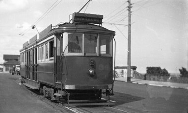
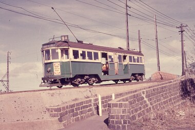
Photograph - Digital image of Geelong tram No. 2 at the Wharf terminus, c1920
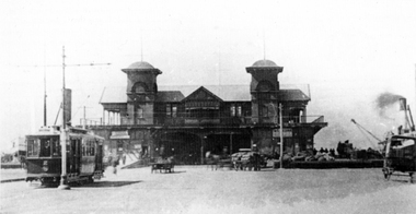
The photograph shows Geelong No. 2, built by Duncan and Fraser of Adelaide in 1911 in its as-built configuration, c1920 at the Wharf terminus, known as the Moorabool Street Pier. The tram line was opened in 1912 and closed in 1940 when the track in Corio St was extended to the Beach terminus. There are a number of horse-drawn vehicles in the view with goods being loaded or unloaded on the ship moored on the right. The tramway was operated by the Melbourne Electric Supply Co. (MESCo). The photograph from the collection of Ken Magor was published in the Sydney Tramway Museum's magazine Trolley Wire in April 1981. The photo caption advises - "The steamship to the right is the Edina, a veteran Port Phillip steamer which was launched in 1854 and was not broken up until 1957." This tram is part of the collection at the Ballarat Tramway Museum.Yields information about Geelong No.2 and the Wharf terminus.Digital image of Geelong tram No. 2 at the Wharf terminus c1920. geelong, wharf, mesco, moorabool st pier, edina, tram 2 -
 Bayside Gallery - Bayside City Council Art & Heritage Collection
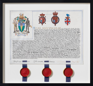
Document - Certificate, College of Arms, City of Brighton Coat of Arms, 1970
The Coat of Arms, represents Brighton City Council's "growing awareness of the importance of formality and correct symbolism in local government". It replaced the council's crest of a pier and yachting scene and was used as council's seal, and emblem on its flag and letterhead. The new Coat of Arms, drawn up by the College of Arms in England, depicts the progression from a seaside gardening community to a modern residential city. The prominent forms are on the shield-like coat of arms include waves and a Lymphad (a ship, symbolic of the sea); a market gardener; an aboriginal man; two horns plenty with abundant fruit and vegetables (the wealth and plenty) and Elster Creek. It is underscored by the motto 'By their fruits, ye shall know them'. Brighton was first incorporated as a borough on 18 January 1859, it became a town on 18 March 1887 and was proclaimed a city on 12 March 1919.Ink and gouache on parchment with wax seals. Allocates a Coat of Arms to the City of Brighton, by the College of Arms in London on 08/09/1970. The Coat of Arms is located on the upper left quadrant and has the following parts: the crest, the wreath, the helmet and mantle, the shield, the supporters, the compartment and the motto. The crest is two cornucopias with fruits and vegetables, above which sits a seagull. The mantle above the helmet is in green and gold. The shield is also green and gold with a lymphad (ship), and blue and white waves, representing the sea. The market gardener, holding a hoe, and Aboriginal figure, bearing a boomerang, support the shield and stand upon the compartment which is soil with a representation of Elster Creek. A ribbon below contains the motto in 'FRUCTU NOSCITUR'. The certificate text explains the origins of Brighton and the parts of the coat of arms. At the bottom of the folded parchment are three signatures and titles, below which three red wax seals in gold tin containers hang from blue ribbons.coat of arms, certificate, city of brighton, college of arms, market gardener, aboriginal, wax seal, elster creek, lymphad, fructu noscitur, letters patent, armorial bearings, heraldry, seal -
 Melton City Libraries
Photograph, Melton Railway Bridge, c.1884
"The Melton Viaduct, opened in 1886, is of State heritage significance as a very large and visually distinctive wrought iron, lattice girder trestle bridge over the Werribee River (now Melton Reservoir). It comprises 18.3 and 9.1 metre spans, in a generally alternate arrangement, of total length 375 metres, and standing 38 metres over the Werribee River. Wrought iron small section iron was used to build tension trussed trestle legs, which supported four lines of rivetted wrought-iron deck-type double lattice trusses. It has bluestone abutments and pier bases of coursed rock-faced bluestone with drafted margins. The larger half-piers, now usually submerged in the Melton Reservoir have sharp tapered cutwaters and curved coping at the tops. While designed to carry two rail tracks it has only ever been used as a single track line. Despite several alterations to its deck structure, it remains an outstanding example of a lighter structural design employing open metal trestle supports and metal truss girders. The direct Melbourne to Ballarat railway link of which the Melton viaduct was the major engineering work contributed significantly to the history and development of Victoria. This new link reflected Ballarat’s diversifying economy as well as the commercial and political influence of the metropolis. Construction of the bridge, and the associated large workers camp, were extensively photographed, documenting an important episode in local history. The railway enabled the development of new industries in the Melton area, notably the timber industry and a chaff industry of national importance, greatly facilitated the later transition of the Shire from a pastoral to a farming economy, and struck a major blow to Melton township’s era as a wayside town servicing Ballarat road (especially coach) traffic". Melton Railway Bridge being built across the Werribee Rivertransport -
 Phillip Island and District Historical Society Inc.
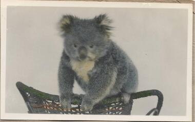
Photographs, 11/1946
Part of a collection of photographs donated by Julie Barnett. Photographs taken whilst Julie's In-law's were on their honeymoon in November 1946.229-32. Black & White photograph of a koala sitting on the back of a wicker chair. 229-33 to 229-37. Black & White photographs of a koala in a tree. 229-38 to 229-40. Black & White photographs Broadwater Guesthouse in Cowes. 229-40 shows a cat in the garden. 229-41. Black & White photograph of the beach at Cowes taken from Broadwater. 229-42. Black & White photograph of the Cowes Pier in the background. 229-43. Black & White photograph of The Nobbies, Phillip Island.wildlife - koala, koalas, broadwater guest house, broadwater guest house cowes, guesthouses cowes phillip island, cowes beach, cowes beach phillip island, cowes jetty, cowes pier phillip island, the nobbies, the nobbies phillip island, julie barnett -
 Phillip Island and District Historical Society Inc.
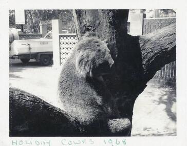
Photographs, 1968 to 1995
A collection of photographs left by an anonymous donor under the Museum door in Cowes, Phillip Island.236-01. Black & White photograph of a koala in low down in the fork of a tree, possibly the Main Street in Cowes. 236-02, 03 & 04. Colour photographs of motor bikes arriving on Phillip Island for the Super Bikes held in November 1995. Taken near the Rhyll turn off from Phillip Island Tourist Road. 236-05. Colour photograph taken from the Cowes Pier looking towards Cowes beach. Band Rotunda obscured in left hand side. Taken 1985236-01 On front: Holiday Cowes 1968. On back: Main Street, Cowes. 236-02 to 04. On back: Super Bike Arrivals & Crowd Nov 95. 236-05 On back: Cowes 1985.wildlife - koalas, motorbikes, superbikes phillip island, cowes beach phillip island -
Port Melbourne Historical & Preservation Society
Plan, "State Bank of Victoria - Proposed dwelling Fishermans Bend"
Plans were brought to us for copying 19.05.2011 by CBA employee Steve Tserkezidis, who has access to old State Bank records. Borrowed for scanning by Gavin Rowson who put them on CD and returned 07.06.2011From series of State Bankhouse plans and elevations of types 1 - 8. A1 copies (.01) 1937 (stamp). (.02) 1928. (.03) 1937. (.04) 1937. (.05) no date. (.06) 1928. (.07) 1937. (.08) 1938. From plans accompanying bank House plans .01 to .08; (.09) MMBW plan showing bank properties (.10) Bank house plan: sections through walls. (.11) "Fishermans bend group" plan of properties (.12) Bank House plan of Pier Foundationgarden city, built environment - domestic, state savings bank of victoria, bank houses -
Port Melbourne Historical & Preservation Society
Photograph - COR/BP tank farm clean-up, Alison Kelly, Aug 1990
Shot when Alision Kelly was caretaker at the nearby 'Mission Art Centre' and displayed there and at the Port Melbourne LibraryFour colour photos of bulldozer working on clean up process on site of former COR/BP tank farm - view to south. Archivally mounted on vertical strip of white card and enclosed in mylar. Photos all looking south; views of equipment scooping out hydro-carbons, soil from pit filled with ground water; top to bottom: Williamstown and Webb Dock in background; white Toyota EAY-921 right foreground; close up; close up; Princes Pier in left backgroundInk on back: 'A. Kelly 645 2324'town planning - proposals shelved - bayside, environment, alison kelly -
Port Melbourne Historical & Preservation Society
Photograph - Relating to Michael McDONOUGH, former Hall Keeper, Port Melbourne Town Hall, 1934 - 1951
Black and white photocopies, A4 laminated .01 - Mrs Mary McDONOUGH and Mr Michael McDONOUGH of 151 Heath Street, standing beside wire gate .02 - Group aboard a steamer at Station Pier Port Melbourne on 14 August 1934. Mr Michael McDONOUGH is identified .03 Death notice for Mr Michael McDONOUGH aged 83. From "The Record" 21/4/1951 which noted that he had been the Hall Keeper at Port Melbourne Town Hall for 38 years.local government - city of port melbourne, local government - town of port melbourne, port melbourne town hall, michael mcdonough, mary mcdonough, heath street, hall keeper -
 Ballarat Tramway Museum
Photograph - B&W print of donated negative, Ron E. Fluck, 7/04/1950 12:00:00 AM
Black and white print of a donated negative. Print made 8/1998. Photo of Victorian Railway tram No.34 at the Brighton Beach terminus. Tram has the destination of "St Kilda Rly Stn". In the overhead can be seen the pan for assisting the driver to put the rear pole onto the wire. Also in the background of the photo is a stone wall of the railway tunnel under the road that served the Brighton Beach Pier. Photo taken 7-4-1950. See Victorian Railways to '62, pages 47 and 49 re railway tunnel.tramways, trams, brighton beach, vr, railway tunnel, tram 34 -
 Bayside Gallery - Bayside City Council Art & Heritage Collection
Map, Department of Crown Lands and Survey, Melbourne and Suburbs, City of Sandringham, 1917-1926
map, plan, foreshores, sndringham, hampton, beaumaris, cheltenham, department of lands and survey, cartographic material, borough of sandringham, moorabbin, black rock, street map, city of sandringham -
 Melbourne Tram Museum
Letter, Australian Electric Traction Association (AETA), "Transporting Melbourne", 4/12/1996 12:00:00 AM
Letter - 8 A4 pages stapled in top left hand corner - AETA to "Transporting Melbourne", Ministry of Transport, dated 4-12-1996 forward comments or making a submission regarding the proposed framework. Endorse the concept, backlog in Melbourne public transport, railway electrification, tramway and light rail extensions; East Malvern Station, Box Hill, Station Pier, Westfield Shopping centre, Highpoint West, South bank Route and other suggestions made regarding re-routing of trams services.trams, tramways, aeta, submissions, new tramway, melbourne, public transport, box hill -
 Melbourne Tram Museum
Slide - Set of 4, Keith Caldwell, 16/03/1966 12:00:00 AM
Set of four Perutz colour slides, grey plastic mount, photo by Keith Caldwell of trams using the single track bridge over the Epping Rail line, (the hump), Preston Workshops - Miller St. .1 - W3 663, Route 9A, Northcote via St Georges Rd. .2 - W2 455 eastbound. showing special - route 11 .3 - W5 749 - as for .1 .4 - W5 - can't read the number. shows the bridge pier prior to be reinforced and the train tracks. 16/3/1966In ink "Bourke 14.3.66" and a purple date stamp.trams, tramways, miller st, the hump, w3 class, w2 class, w5 class, bridges, preston workshops, northcote, route 9a, tram 663, tram 355, tram 749 -
 Orbost & District Historical Society
black and white photograph, mid 1930s
This is a photograph of McKillop's Bridge probably taken just after its rebuilding. The current McKillop’s Bridge was built by the Country Roads Board in two stages between 1931-36, during which its height was raised after the original bridge superstructure was washed away in record floods of January 1934, prior to its original official opening. In its reconstructed form the original concrete abutments were turned into additional piers and the welded-steel trusses were cantilevered back over them to meet the new higher road approaches. "McKillops Bridge was Heritage listed due to its social and technological significance – the steel trusses' arc-welded construction technique was a pretty big deal in the 1930s. It was once an important route for cattlemen, who used the ford across the Snowy in the years preceding the bridge's existence"This is a pictorial record of McKillop's Bridge just after its construction.A black / white photograph of a wooden bridge across a river. At the bottom right is a man with his back to the camera. He is looking at flood debris on the bank. At the bottom left are two men near a pylon.on back - McKillops Bridgebridge-mckillop's snowy-river-bridge -
 Flagstaff Hill Maritime Museum and Village
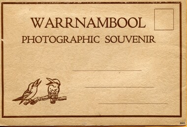
Postcard - Postcard Folder, scenes, Valentine & Sons Co. Publishing Ltd, Warrnambool Photographic Souvenir, Early-to-mod 20th century
This postcard folder is one of three in a set of postcards that were published in Victoria, Australia, and collected together. The Valentine Publishing Co. Pty. Ltd. produced this folder. Valentine and Sons was a printing and photography business based in Dundee, Scotland, and in Canada. In the early 1900s, at the height of the postcard craze, the firm published large numbers of postcards in the U.K., Canada, U.S., Australia and South Africa. From around 1900 or earlier, the firm bought many lithographic images for its postcards from local and national photographers who sold publishing rights to Valentines, and the business was famous for publishing photographs of popular sites worldwide. Postcard titles in this folder include many of those in the Rose postcard folders plus the following titles that are not duplicated. . Municipal Buildings and Post Office . Soldiers’ Memorial . Hopkins River . The Cliffs at Shelly Beach . The Road to Sandy Beach . The Breakwater and Pier This Valentine postcard folder was produced in Australia. It includes pictures from the early-to-mid 20th century. It is one of three in a set, with images of the same locations as other images in our collection but at different periods in time. Each postcard records a moment in history and is significant as a way to compare and show the changes in the local environment and community, building a story of the local history. The images record changes in the coastline, land, bay, buildings and other structures, roads, transportation and even the fashions of the times.Postcard folder, Valentine Publishing, cream cover. One of a set of three displaying images of Warrnambool and district around the mid-20th century. Print on the front and back covers is in brown ink. The front has an image of two laughing kookaburras on a branch, three address lines and an outline for a postage stamp. The back cover has the publisher’s details and a line for a return address. The cover opens like a book, and then the double-sided, Z-folded page of photographs drops downward. Titles are printed below each of the fifteen black and white photographs inside. The folder is secured on the back cover by placing a tab into a slot. The folder was produced by The Valentine Publishing Co. Pty. Ltd. Melbourne“WARRNAMBOOL / PHOTOGRAPHIC SOUVENIR” Symbol: [Two facing kookaburras standing on a branch with beaks open] “Published by The Valentine Publishing Co. Pty. Ltd. Melbourne” flagstaff hill maritime museum and village, great ocean road, shipwreck coast, warrnambool, flagstaff hill, flagstaff hill maritime museum, flagstaff hill maritime village, warramble, postcard, postcard folder, warrnambool scenes, picturesque views of warrnambool, picturesque views of warramble, lady bay, port of warrnambool, breakwater, warrnambool breakwater, viaduct, merri river footbridge, merri river suspension bridge, suspension footbridge, merri river mouth, hopkins river mouth, proudfoot's, fanny nelson, nelson's boatsheds, nelson's boathouse, boathouse, hopkins river boathouses, flett's boathouse, flett, george rose, image of a rose, rose series, rose stereograph co, rose stereographic company, lighograph, armadale victoria, lady bay beach, beach scene, lower light, concrete footbridge, 1922 footbridge, viaduct road, rose postcard, new concrete bridge, 1945, 1890, 1922, small footbridge, 1872 footbridge, 1872, merri river estuary, stingray bay, postcards, concertina fold, z fold, shipwrecked coast, maritime museum, souvenir, warrnambool local scenes, photography, local history, tourism, photographs, visitors, travel, scenes, mid-20th century, 1940s, 1950s, z-fold, 1880s, collection, correspondence, valentine publishing co. pty. ltd melbourne, valentine publishing co. pty. ltd sydney, municipal buildings and post office, soldiers’ memorial, hopkins river, the cliffs at shelly beach, the road to sandy beach, the breakwater and pier -
 Orbost & District Historical Society
black and white photograph, July 1922
A new bridge over the Snowy River at Orbost was opened for traffic on June 20th 1922. It was designed for future joint use by road and railway traffic, but it was only used for road traffic. During the last few years the condition of an old suspension bridge [the 1893 bridge] which was the only vehicular crossing between the town of Orbost and the railway station, caused much concern. The structure was of timber, except for the wire suspension cables of its central span of about 100 feet. A design was prepared in 1914 for a permanent bridge with five spans of 85 feet composed of plate girders on concrete piers. With great increase in the price of steel work during the war, the cost of this design became prohibitive, and the need for a new structure becoming urgent, alternative proposals were investigated. As a result the present design was adopted as providing a sem-permanent bridge at moderate cost. The new bridge spans the river about 160 feet upstream from the old bridge on a slight skew, the piers being at an angle of 80 degrees with the centre line of the bridge. It has a camber of about 2 feet 5 inches in its total length of 527 feet. ( information from Newsletter March 2014 - Lois Crisp) The photograph shows Mrs James Cameron cutting the ribbon at the opening of the Orbost Pile Bridge in 1922. This second bridge, was built by the Victorian Railways and the Country Roads Board. Constructed at a cost of 35,000 pounds and used second-hand girders from the Flinders Street- Spencer Street viaduct. On July 4 1922 it was officially opened by Mrs James Cameron. Unfortunately, her husband, who had long championed the building of the bridge so that it would be ready for the railway to continue to the border, was too ill to attend the ceremony. In fact, James Cameron died on July 13 after a long and severe illness (ref. S.R.M. 20.7.1922). There is a section of this ribbon in the collection - Registration No. 366. This is a pictorial record of a significant event in Orbost's history.A black / white photograph of a pile bridge with a suspension bridge behind it. There are many people standing on the bridge.on back - "Opening of Pile Bridge - 1922"snowy-river-bridge ceremonies cameron-mrs -
 Phillip Island and District Historical Society Inc.
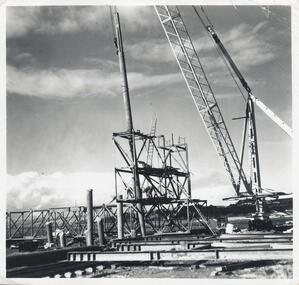
Photographs, Phillip Island 2nd Bridge Construction, 1966 - 1969
22 of a collection of 70 Black & White photographs taken during the construction of the second Phillip Island Bridge from San Remo to Newhaven by Country Roads Board and Shire of Bass. Contractor John Holland & Co. Pty. Ltd.14 Black & White photographs of the construction of the second Phillip Island Bridge in 1966 - 1969. 351-09: Pile driving on Newhaven abutment. 351-10 & 11: Concrete beams. 351-12: Pile driver. 351-13 & 14: Machinery. 351-15: Dismantled section of cylinder. 351-16 & 17: Coffer dam and pier construction. 351-18: Man up on scaffold. 351-19 & 20: Construction work. 351-21: Two workmen and man leaning on section of handrail exposed to weather. 352-22: View of construction work.Descriptions as above on some. Plus the following Numbering: 351-09: CRB NEG 67-274C. 351-10: CRB NEG 67-542. 351-11: CRB NEG 67-654F. 351-12: CRB NEG 66-605. 351-13: CRB NEG 66-601. 351-14: CRB NEG 68-752B. 351-15: CRB NEG 67-936. 351-16: CRB NEG 67-937A. 351-17: CRB NEG 67-937B. 351-18: CRB NEG 67-1156D. 351-19: CRB NEG 67-1156B. 351-20: CRB NEG 66-1026E. 351-21: CRB NEG 67-940. 351-22: CRB NEG 67-1218Bphillip island bridge construction, 2nd phillip island bridge construction, country roads board, shire of bass, sasha stark -
Glenelg Shire Council Cultural Collection
Photograph - Sheet of 10 contact prints - Various Portland historic buildings and landmarks, c. 1970
Sheet of 10 contact prints of rephotographed photographs. Identifying numbers 5715a, b, c, d, e, f, g, h, i, j (a) Portland form Battery Point (b) Henty Beach, looking south (c) Palmer Street Primary School, No. 489 (d) Guardian Office, Bentinck Street (e) Railway Station Harbour Baths Bentinck Street (f) Jane Henty - wife of Stephen (g) bullock dray, bush (h) Ocean Pier (i) Bentinck Street Percy Street (j) Henty BeachFront: (a) Portland from Battery Point. - The Rose Series (c) .... School, Portland Vic. - Toys Photo (d) Bentinck Street The Guardian Office Portland. - Magnus Photo (e) Railway Harbour & Jetty (f) Price $3.70 (i) Bentinck Street Percy Street The Harbour and Town of Portland (j) Henty Beach, Portland -
Port Melbourne Historical & Preservation Society
Plan - CD-ROM, "State Bank of Victoria - Proposed dwelling Fishermans Bend"
Plans were brought to us by CBA employee Steve Tserkezidis CD with items below. From series of State Bankhouse plans and elevations of types 1 - 8. A1 copies (.01) 1937 (stamp). (.02) 1928. (.03) 1937. (.04) 1937. (.05) no date. (.06) 1928. (.07) 1937. (.08) 1938. From plans accompanying bank House plans .01 to .08; (.09) MMBW plan showing bank properties (.10) Bank house plan: sections through walls. (.11) "Fishermans bend group" plan of properties (.12) Bank House plan of Pier Foundationgarden city, built environment - domestic, state savings bank of victoria, bank houses -
 Port Melbourne Historical & Preservation Society
Photograph - Relating to Ed Whiting, 1930s
See 1833.02 for more information about Little Bay St. Ed WHITING lived in Dow St Port Melbourne in 1930s (A PMHPS Member in 2000s). Photos copied by Ed WHITING for PMHPS include Violet JOHNSON (now WOODS) as a little girl and later as a young woman. Shows 1930s Port Melbourne life.Note that .01, .02, .05 are in hard copy and a copy of all six is on database Black and white photos (copies) from the 1930s .01 - Ed WHITING and friend Ron .02 - Ed WHITING and three friends at BP filling station on Beach St near Princes Pier .03 - Ed WHITING and two friends in Port Melbourne lane.(database) .04 - Violet JOHNSON and friends, Port Melbourne backyard area (database) .05 - Violet JOHNSON and friend on Little Bay St .06 - Violet JOHNSON with pretend gun (database)families, domestic life, built environment - domestic, engineering - roads streets lanes and footpaths, edwin whiting, violet johnson, violet woods johnson -
Melbourne Tram Museum
Newspaper, Docklands News, “New late-night trams for La Trobe St”, Feb 2019
Newspaper clippings titled: “New late-night trams for La Trobe St” - Docklands News, February 2019, Issue 149. New tram timetable for Route 30 from January 1 2019. Tram services will run from St Vincent's Plaza to Central Pier until 1am on Fridays and Saturdays, and until midnight from Sundays to Thursdays. Previously there were no weekend services on route and weekday services finished at 6pm. Minister for Public Transport, Melissa Horne, said government making it easier to catch public transport.trams, tramways, route 30, docklands, la trobe st -
 Bayside Gallery - Bayside City Council Art & Heritage Collection
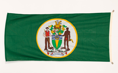
Flag, Evan Evans, City of Brighton flag
The coat of arms on this flag were granted by the British College of Arms in 1970 and represented Brighton City Council's "growing awareness of the importance of formality and correct symbolism in local government". It replaced the council's crest of a pier and yachting scene and was used as council's seal, emblem on its flag and letterhead. The new Coat of Arms, drawn up by the College of Arms in England, depicts the progression from a seaside gardening community to a modern residential city. The prominent forms are on the shield-like coat of arms include waves and a Lymphad (a ship, symbolic of the sea); a market gardener; an aboriginal man; two horns of plenty with abundant fruit and vegetables (the wealth and plenty) and Elster Creek (now Elster Canal). It is underscored by the motto "By their fruits, ye shall know them". Brighton was first incorporated as a borough on 18 January 1859, it became a town on 18 March 1887 and was proclaimed a city on 12 March 1919.Green flag with circular City of Brighton Coat of Arms in the centre. The central circle is white with a yellow edge, with a polychrome coat of arms featuring: the crest which is two cornucopia with fruits and vegetables, above sits a seagull. The mantle above the helmet is in green and gold. The shield is also green and gold with a lymphad (ship) and blue and white waves. The market gardener, holding a hoe, and Aboriginal figure, bearing a boomerang, support the shield and stand upon the compartment which is soil with a representation of Elster creek. A ribbon below contains the motto in blue 'FRUCTU NOSCITUR'.flag, brighton, city of brighton, coat of arms, college of arms, market gardener, aboriginal, elster creek, lymphad, fructu noscitur, armorial bearings, heraldry, cornucopia, by their fruits ye shall know them, motto -
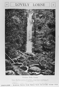 Lorne Historical Society
Pamphlet - Tourist Brochure, Lovely Lorne
The Victorian Railways promoted tourist destinations around Victoria. A folded paper tourist brochure about Lorne The front cover is a coloured painting of Lorne from above the Erskine River towards the main beach. , on the back is a black and white sketch tourist map of the roads, tracks and beauty spots. Inside the first fold are 6 black and white photographs, Cumberland River, Mt St George, Phantom Falls, Cumberland Cliffs, Teddy’s Lookout, leafy walk towards the pier. Inside contains written descriptions of the highlights of Lorne and six black and white photographs, four general views of Lorne, Lover’s Walk, Erskine Falls . souvenirs, victorian railways, publicity